Ticker for August 19, 2025
MESONET TICKER ... MESONET TICKER ... MESONET TICKER ... MESONET TICKER ...
August 19, 2025 August 19, 2025 August 19, 2025 August 19, 2025
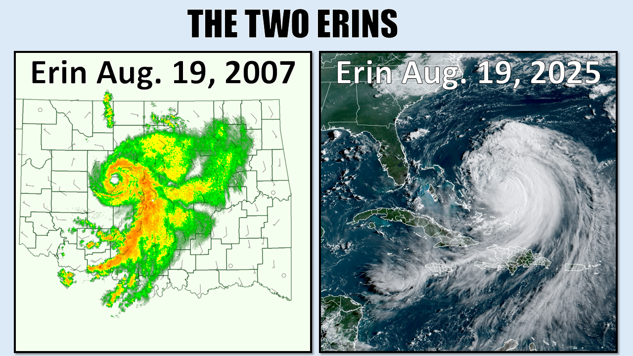
Erins for everybody
Much like Gary Busey with too much coffee, the Ticker is off today, but I thought
I'd give a quick Tick Tocking about Oklahoma's foray into Tropical disasters
(other than that shirt you wore for Hawaiian Day at work last year...you know who
you are) from 18 years ago, overnight on Aug. 18 into the 19th.
What happened? Oh, just one of the rare instances in recorded history when a
decaying tropical system reintensified over land, in defiance of the physics
and thermodynamics of how such things work with hurricanes and tropical storms
and tropical depressions and whatnot. And it happened right over the State of
Oklahoma, creating one of the worst flooding disasters the state has seen in
the last few decades.
We certainly weren't dealing with a full-fledged hurricane like the current Erin,
which has been up to a Cat-5 monster and forecast to mirror the East Coast of
the U.S., but ours was bad enough nevertheless.
Here's what we wrote back in the fall of 2007 for our Fall Seasonal Summary
series at the time. It might be a bit dated, but still some good info in there.
Let's take a trip back 18 years...
-------------------------------------------------------------------------------
Tropical Depression Erin unexpectedly reintensified during the overnight hours
of August 18-19, 2007, over western Oklahoma. The resulting heavy rains,
tornadic activity, and severe winds caused widespread damage to parts of the
state, and the human tragedy of Tropical Storm Erin continued for several days
after the event. Seven people drowned in floodwaters, including five victims
who were recovered from their vehicles. Other occupants of stranded vehicles
were rescued, including two persons who were lifted to safety by the Oklahoma
Highway Patrol on live national television. Six rural electric cooperatives
sustained over $860,000 in damages due to straight-line winds.
The Uniqueness of Erin
Although Oklahoma’s southern border is 300 miles inland from the Gulf of Mexico,
tropical cyclones originating in both the Atlantic and Pacific Oceans impact
the local weather from time to time. The most common consequences of
landfalling tropical systems on Oklahoma are heavy rains and associated inland
flooding, often as the system or its remnants interact with a stalled frontal
system. For example, Tropical Storm Dean formed in the northwest Gulf of Mexico
in August 1995 and, with an overland path similar to that of Erin, interacted
with a stationary front to produce 16 inches of rainfall across Oklahoma and
major flooding along much of the Cimarron, Washita, Arkansas, and Salt Fork of
the Arkansas Rivers.
Only four recorded tropical cyclones maintained tropical storm strength as far
inland as Oklahoma, including the Galveston Hurricane of 1900 and Hurricane
Carla in 1961. The Galveston Hurricane, estimated as Category-4 at landfall,
delivered winds as high as 70 mph and dumped flooding rains across the
pre-statehood Indian Territory. Likewise, Hurricane Carla (also Category-4)
struck the Texas Gulf Coast in September 1961; it maintained tropical storm
strength across Oklahoma, and rained up to nine inches when it interacted with
a stationary front.
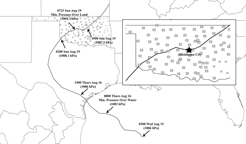
Erin's redevelopment was unique for the following reasons: (1) its location
more than 300 miles within inland; (2) its inland intensification produced
greater sustained wind observations and lower central pressure values than when
it was over open water; and (3) the redevelopment occurred over a region
equipped with a dense observing system, such as the Oklahoma Mesonet.
The Rise and Fall of Erin
Erin's life-cycle began as Atlantic Tropical Depression Five, which organized
in the south-central Gulf of Mexico and moved generally northwestward. The
depression was upgraded by NOAA’s Tropical Prediction Center to Tropical Storm
Erin at 10:30 a.m. on August 15. Erin spent less than 24 hours as a named storm
in the Gulf, and given that its organization was unimpressive throughout its
time over water, it never threatened to achieve hurricane status.
At 11:00 p.m. on August 18, Oklahoma Mesonet wind sensors detected Erin's
circulation in southwestern Oklahoma. The first indication of Erin's
intensification to tropical storm criteria was a series of 1-minute wind speeds
that exceeded 39 mph between 11:15-11:40 p.m. at the Medicine Park Mesonet
site. The longest duration of these stronger winds was four minutes. The Fort
Cobb Mesonet site recorded tropical storm strength winds during most of the
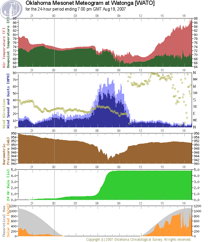
period from 12:15-12:40 a.m. According to Oklahoma Mesonet observations, the
storm reached its greatest intensity near Watonga between 1:00-4:00 a.m. When
the circulation's center passed just south of Watonga, the station recorded the
event's peak sustained wind of 58 mph.
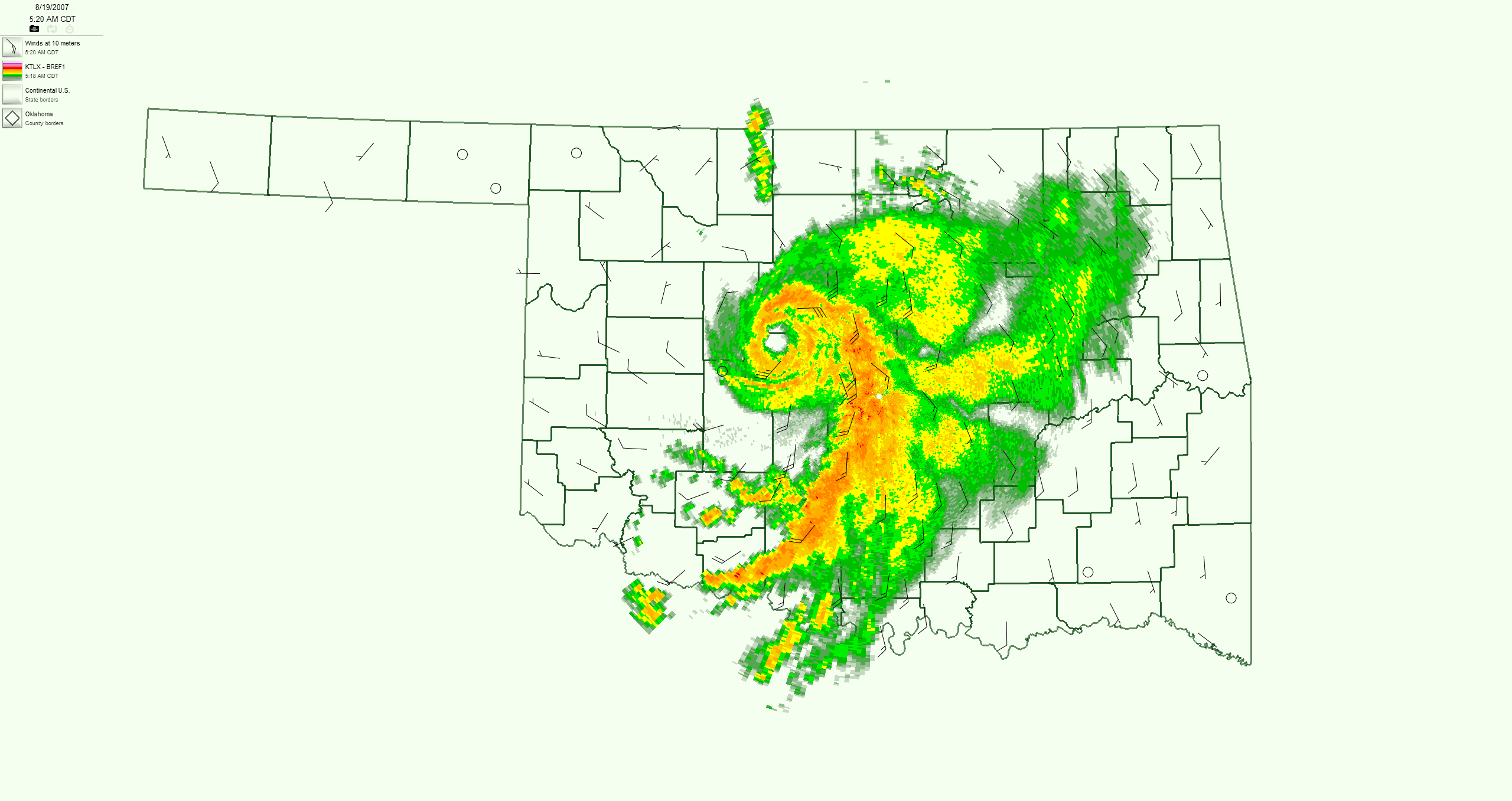
At 4:50 a.m., radar displayed the first appearance of an eye west of Geary.
Additionally, spiral bands typical of tropical cyclones formed to the east and
south of the eye. During the following 30-minute period, convective elements
developed and weakened during the eye formation, and by 5:50 a.m., the eye wall
was nine miles wide and centered just north of Calumet. During the next two
hours, the eye fluctuated in diameter from 3-15 miles as convection pulsed
within the surrounding eye wall. By 7:00 a.m., Erin's circulation had
intensified significantly across west central Oklahoma and moved into central
Oklahoma. At 9:50 a.m., the eye tracked over Oklahoma City and began to
dissipate. The eye expanded in size while convection on the western side of the
eye wall diminished. The intense convective cells associated with Erin
propagated eastward into eastern Oklahoma and Arkansas while the general
circulation translated to the northeast and began a more classic transition
from a tropical to an extra-tropical system. By 7:00 p.m. the vortex had moved
into southeast Kansas.
Erin’s Impacts
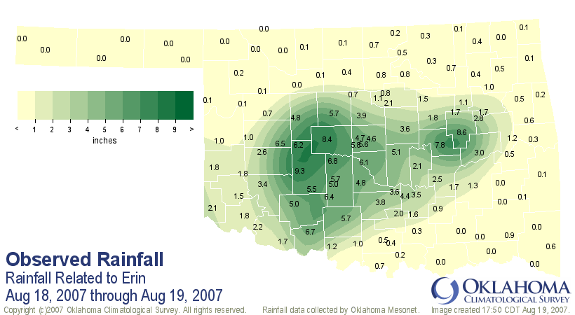
Erin produced prolific rainfall over Oklahoma and rainfall amounts exceeded
existing records for several time scales. The storm's greatest rainfall totals
were observed in west central Oklahoma, where the Watonga NWS cooperative
observer and Fort Cobb Mesonet site both reported daily rainfall of 9.1 inches
and 9.0 inches on August 19, respectively. The value at Watonga exceeded the
100-year rainfall event. At the Fort Cobb Mesonet site, 9.3 inches was observed
during the 24-hour period ending 8:00 a.m. on August 19, eclipsing the 100-year
event for that duration. The vast majority of that total (9.1 inches) fell
during 12 hours, which was nearly a 500-year event. The Fort Cobb rainfall of
7.4 inches during a 3-hour period easily exceeded the estimated 100-yearr event
for that location and duration, and was comparable to the 500-year magnitude as
well.
Gary McManus
State Climatologist
Oklahoma Mesonet
Oklahoma Climatological Survey
gmcmanus@ou.edu
August 19 in Mesonet History
| Record | Value | Station | Year |
|---|---|---|---|
| Maximum Temperature | 111°F | GRA2 | 2024 |
| Minimum Temperature | 51°F | ELRE | 2015 |
| Maximum Rainfall | 8.55 inches | OKMU | 2007 |
Mesonet records begin in 1994.
Search by Date
If you're a bit off, don't worry, because just like horseshoes, “almost” counts on the Ticker website!