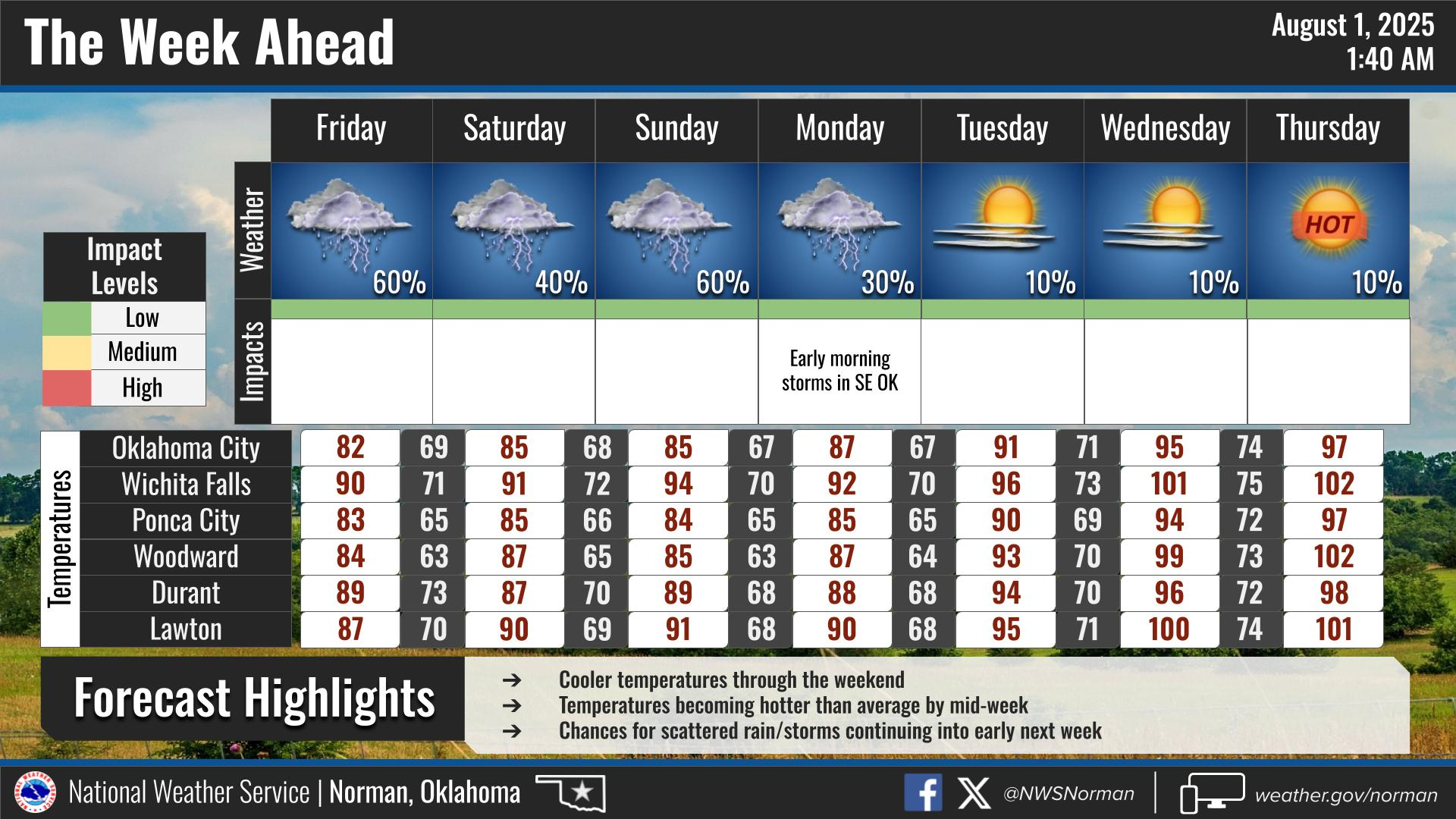
Ticker for August 1, 2025
MESONET TICKER ... MESONET TICKER ... MESONET TICKER ... MESONET TICKER ...
August 1, 2025 August 1, 2025 August 1, 2025 August 1, 2025
Goodbye July Brick Road
Now I KNOW there ain't nobody out there reading today. You're all out buying
those clothes for tax-free weekend...and most of ya don't even have school kids
to buy for! But that's okay.
It's a bit of a foe pa...feux pah...mistake to send out the July summary press
release on a Friday, but we're trying to bury the CPC August drought outlook
that shows drought coming BACK into SW and Central OK through the end of this
month (scroll to the press release below for that ugly image).
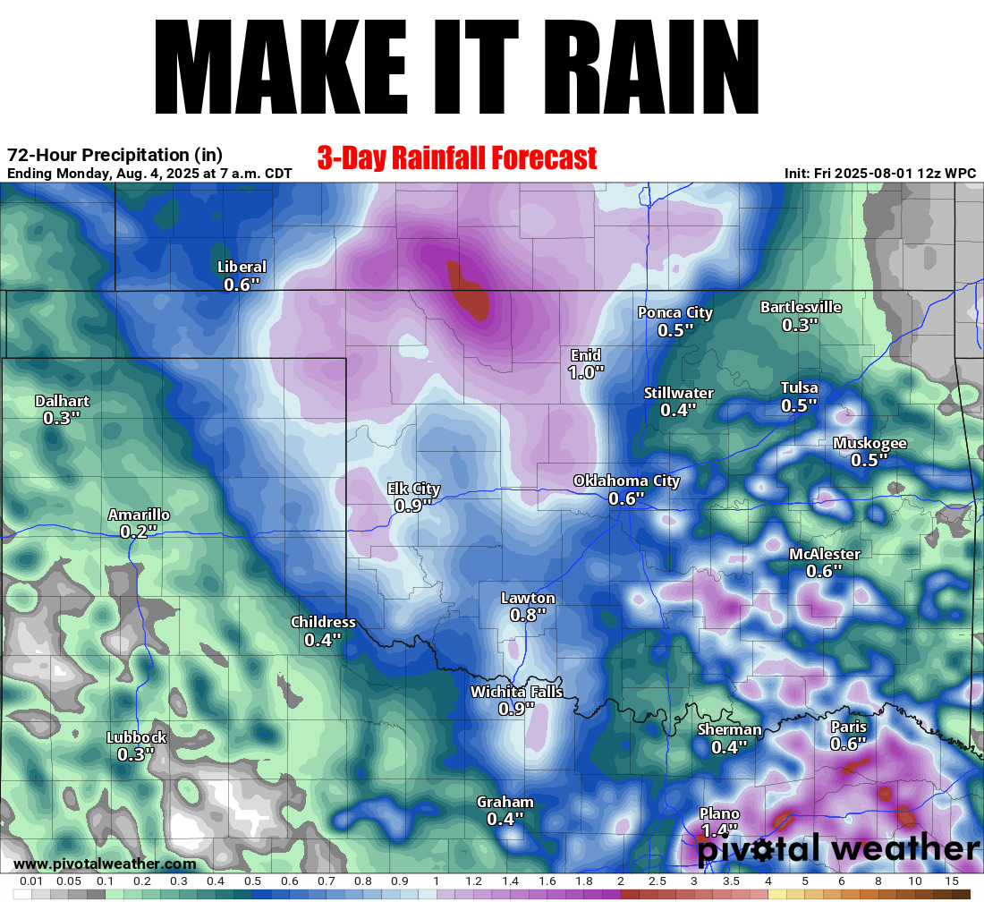
And if that happens, I promise there'll be shenanigans. So we need that rainfall
shown on the top graphic. Rain? Heck, it's raining right now, for crying out
loud!
And it did indeed escalate quickly.
So for now, let's just enjoy the mild, rainy weekend.
And then...possible shenanigans.
---------------------------------------------------------------------------------
Summer Reclaims Headlines During July
Aug. 1, 2025
After months dominated by rain and severe weather, summer finally reclaimed the
spotlight in Oklahoma during July. The state’s wet streak ended, replaced by
rising heat and drying conditions. A lone tornado touchdown near Vance AFB
extended the tornado streak to five consecutive months, bringing the 2025 total
through July to 88. Sweltering July heat held off for much of the month but
surged during the final two weeks—only to be abruptly cut short by an unusually
strong cold front on July 31. The combination of warming temperatures and
dwindling rainfall brought a return of those unwelcome shades on the U.S.
Drought Monitor map, signaling the reemergence of drought concerns.
Summer Weather Returns
Oklahoma enjoyed a mild and wet first half of summer through mid-July. Just
four triple-digit temperatures had been recorded across the Oklahoma Mesonet’s
120 sites through July 18. However, recent rains often pushed heat index values
above the 100-degree mark in many areas. A good old-fashioned Oklahoma heat wave
began on July 18, with triple-digit highs every day thereafter and heat index
values soaring into dangerous territory. The month ended with 254 triple-digit
temperatures recorded by the Mesonet, peaking at 106 degrees at Kingfisher on
July 30. Factoring in Oklahoma’s famous humidity, the Mesonet calculated 2,055
triple-digit heat index values during the month, including 876 that reached at
least 105 degrees. The highest heat index reading was 114 degrees at Cherokee
on July 21.
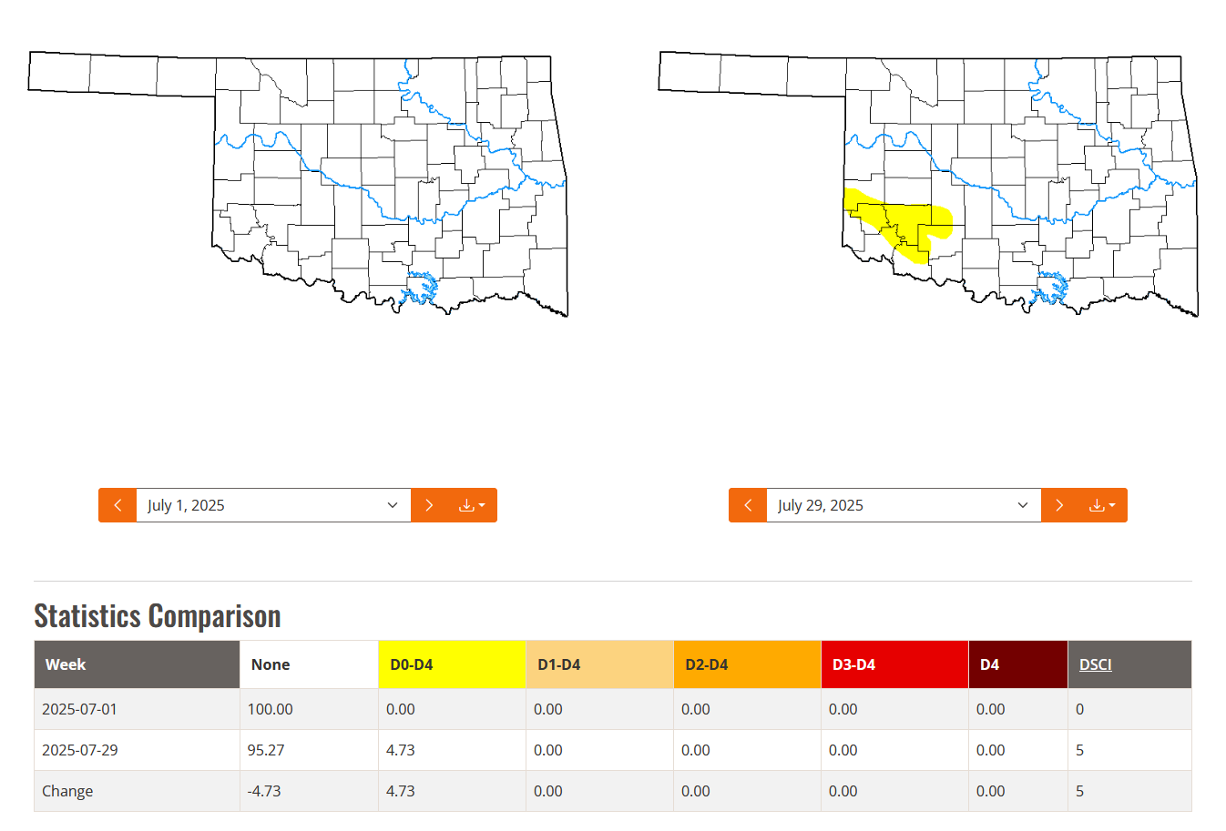
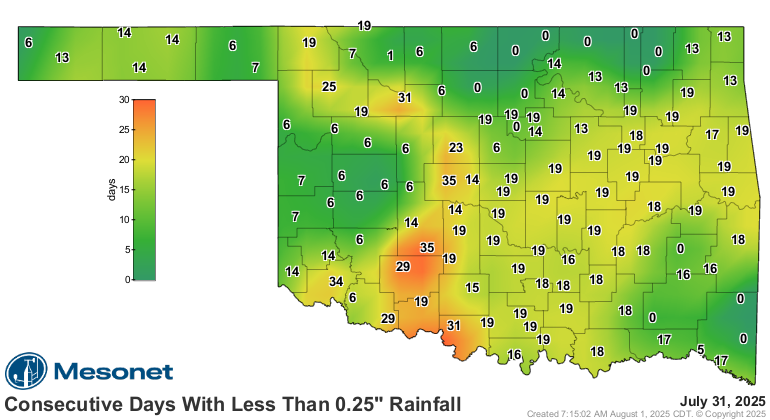
Drought Threatens Return During July
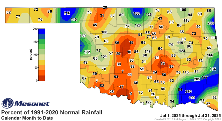
Drought, which had largely retreated from Oklahoma in June for the first time
in nearly six years, began creeping back during July. An area of abnormal
dryness (D0) was reintroduced in southwestern Oklahoma on the July 8 U.S.
Drought Monitor map, initially covering just 1.24% of the state. That coverage
grew to 4.73% by month’s end. The Oklahoma Mesonet reported it had been as long
as 35 days since parts of the southwest had received at least a quarter-inch of
rain in a day, with at least 19 dry days across a broad portion of the
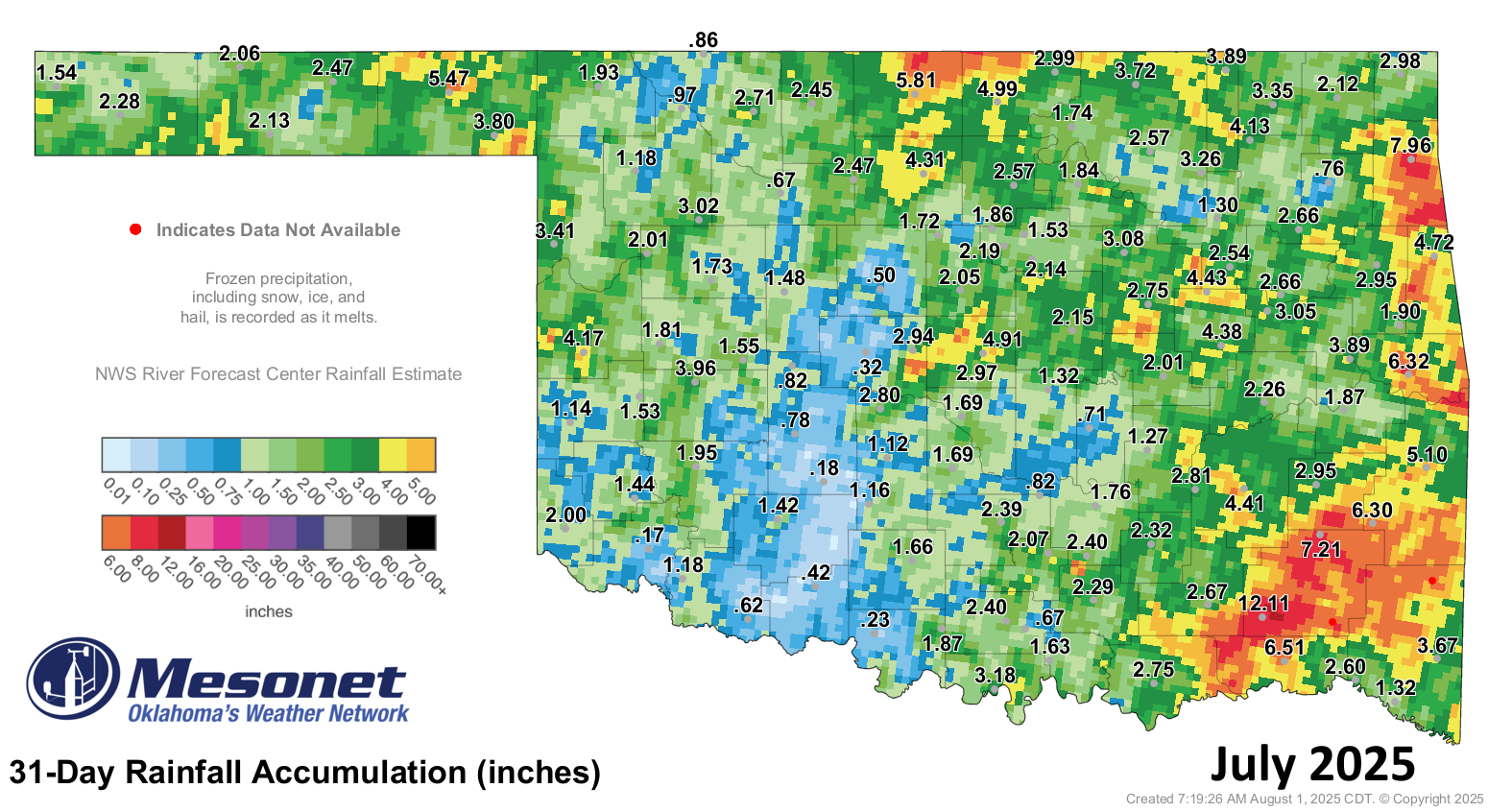
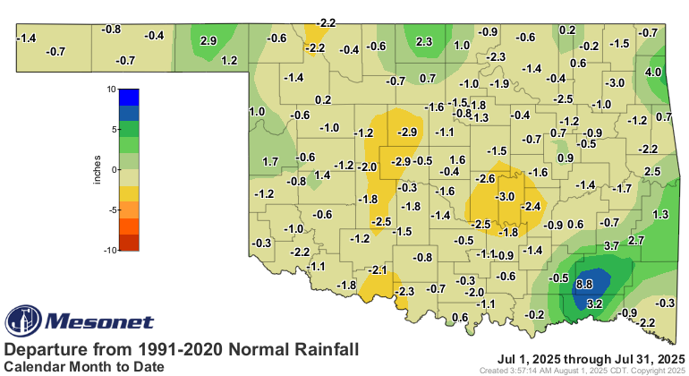
southeastern half of the state. Monthly rainfall deficits climbed to 1–3 inches
across the southeast and 1–2 inches in the northwest. The statewide average
precipitation finished at 2.64 inches—0.56 inches below normal—ranking as the
59th-driest July since records began in 1895. Forty-eight Mesonet sites
recorded less than 2 inches during the month, including 16 with less than an
inch. Antlers reported the highest July total with 12.11 inches.
2025 Tornado Count Creeps Up
There was only a single confirmed tornado in Oklahoma during July—right in line
with the long-term July average of 1.6—but it pushed the year-to-date total
well above the annual average of 59, reaching a preliminary count of 88 for the
first seven months of the year. The January–July average is 51. Of those 88
tornadoes, two were rated EF3 on the Enhanced Fujita Scale, with three rated
EF2, and 70 classified as either EF0 or EF1. Thirteen tornadoes were rated EFU,
indicating unknown intensity. No EF4 or EF5 “violent” tornadoes had been
confirmed in the state through the end of July 2025.
July by the Numbers
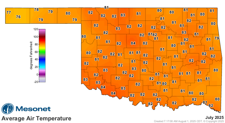
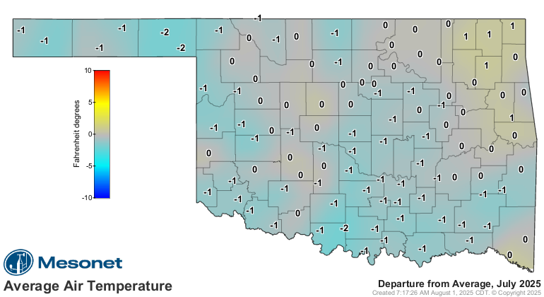
- Statewide average temperature: 81.7°F, or 0.2°F below normal — the 62nd-
warmest July since records began in 1895
- Temperature extremes: High of 106°F at Kingfisher on July 30; low of 58°F at
Eva on July 7, and again at three more sites on July 13; highest heat index,
114°F at Cherokee on July 21
- Warmest/Coolest locations: Highest monthly average temperature, 84.8°F at
Grandfield; lowest, 76.4°F at Boise City
- Statewide average precipitation: 2.64 inches, or 0.55 inches below normal —
the 59th-driest July on record
- Rainfall extremes: High of 12.11 inches at Antlers; low of 0.17 inches at
Altus
- Rainfall totals less than 2 inches: 48 instances recorded at the 120 Oklahoma
Mesonet sites, including 16 with less than an inch
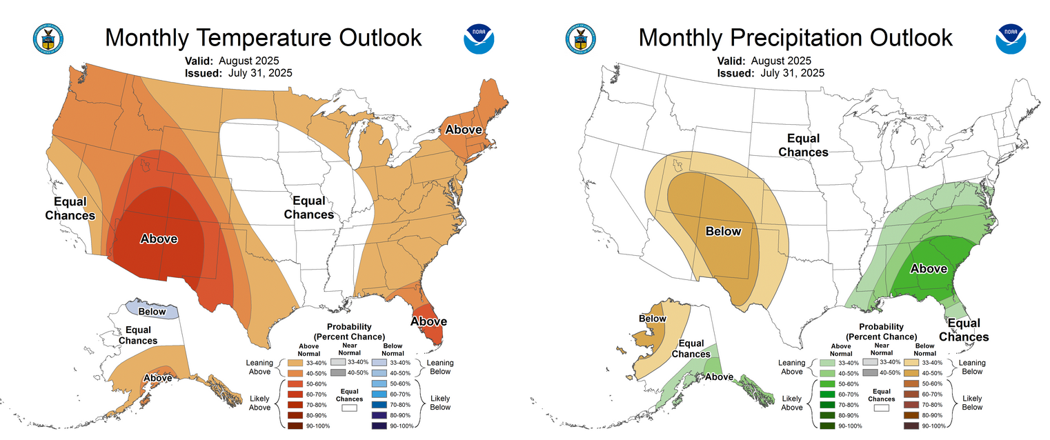
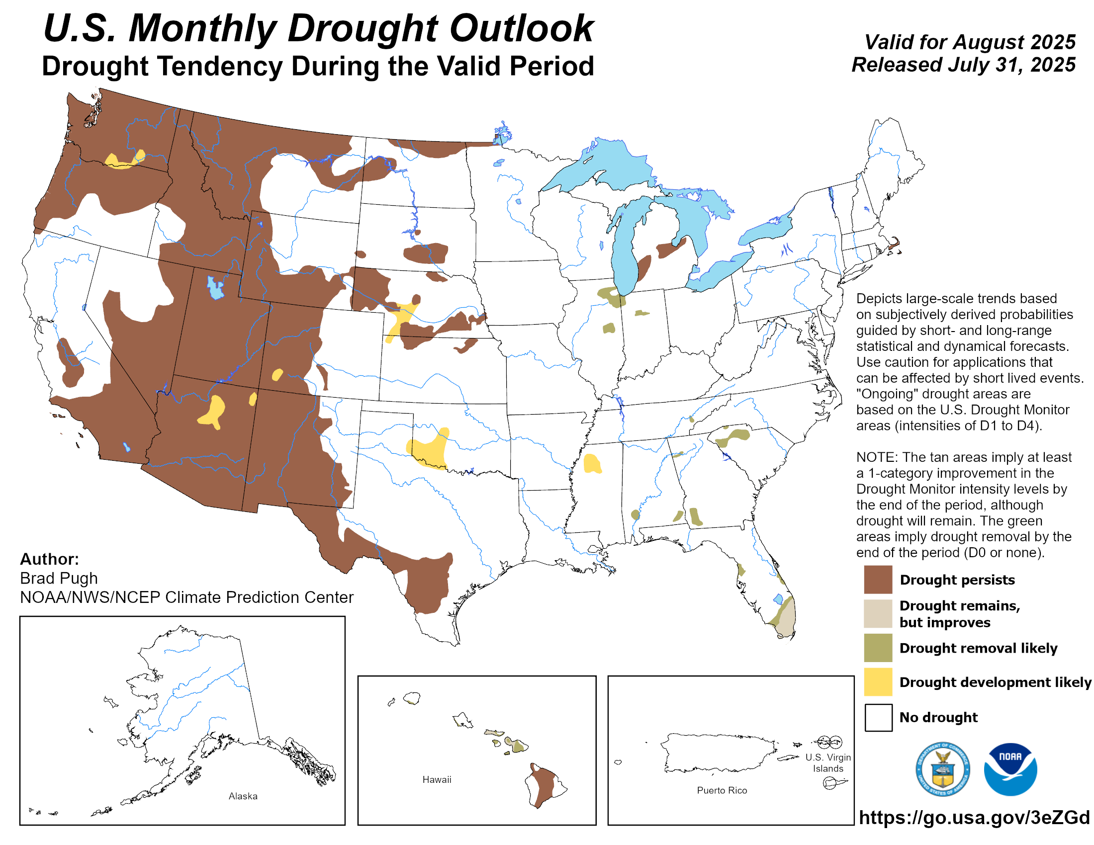
Drought Development Likely During August
The Climate Prediction Center’s (CPC) August outlook indicates increased odds
of above-normal temperatures and below-normal precipitation across the western
third of Oklahoma, with equal chances of above-, below-, or near-normal
conditions across the eastern two-thirds. The CPC’s August drought outlook
calls drought development “likely” across the southwest quarter of the state,
extending into the western edge of central Oklahoma.
###
Gary McManus
State Climatologist
Oklahoma Mesonet
Oklahoma Climate Survey
gmcmanus@ou.edu
August 1 in Mesonet History
| Record | Value | Station | Year |
|---|---|---|---|
| Maximum Temperature | 115°F | KIN2 | 2012 |
| Minimum Temperature | 53°F | KENT | 2018 |
| Maximum Rainfall | 5.04 inches | NOWA | 1995 |
Mesonet records begin in 1994.
Search by Date
If you're a bit off, don't worry, because just like horseshoes, “almost” counts on the Ticker website!