Ticker for February 11, 2025
MESONET TICKER ... MESONET TICKER ... MESONET TICKER ... MESONET TICKER ...
February 11, 2025 February 11, 2025 February 11, 2025 February 11, 2025
Danger zone
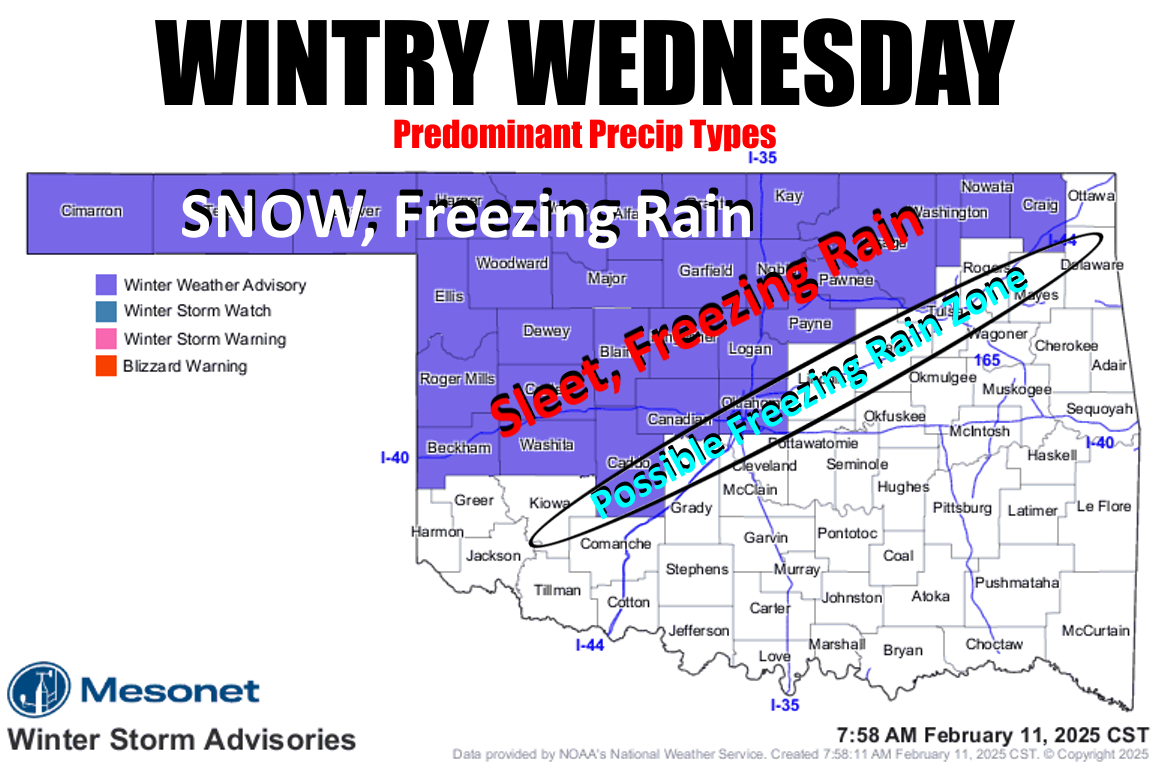
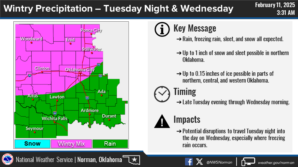
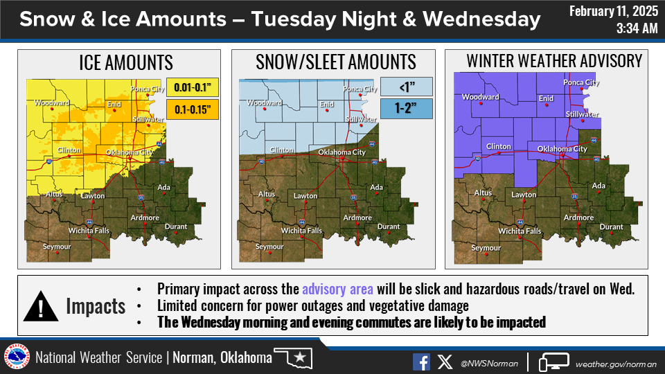
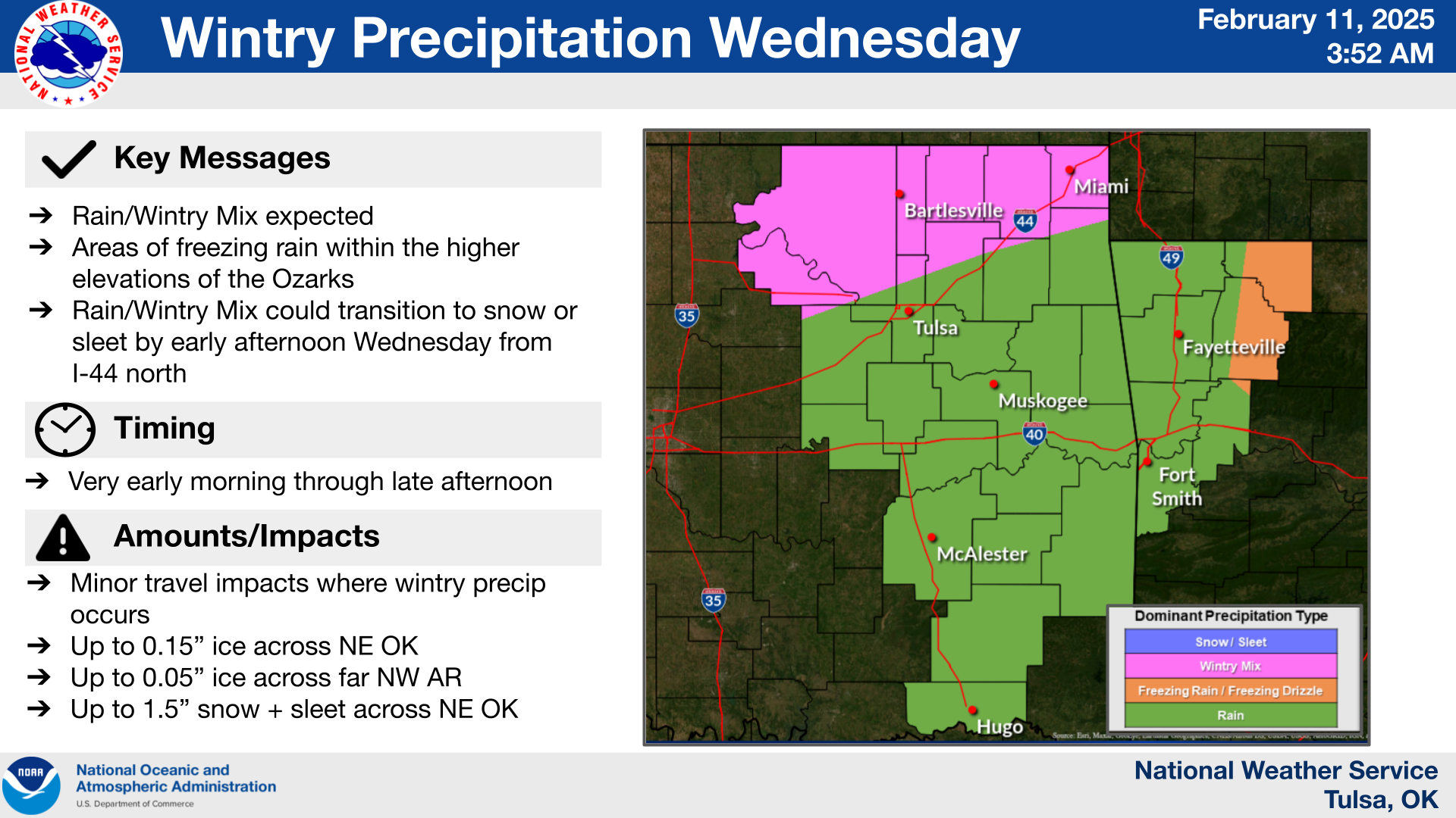
Still looking at a probable winter storm across the NW half of the state, with
snow, freezing rain, and sleet all being possible. Oh, and rain, too.
The latter is welcomed, much of the former is not. However, amounts have definitely
trended down in the last couple of days.
That's a double-edged rake, right (swords are dangerous)? Less moisture, less
impactful wintry weather. Less moisture, less drought (or dry spell) relief.
Know what else is impactful? Quicksand. Growing up in the 70s and 80s, I really
thought I'd run into more quicksand. Every other movie and TV show had somebody
getting stuck in quicksand.
Also, cursed idols. You know, little figurines that would bring you bad luck
in hilarious situations? Hey, I saw "Gilligan's Island" and "The Brady Bunch."
I KNOW what can happen!
But we've gotten off-track. Has the storm system? I'm a bit concerned about the
I-44 corridor maybe getting a bit of freezing rain tomorrow morning. That's why
I have it in the "possible" zone. It all depends on how far south that arctic
front can make it. Of course, I'd prefer it to stay IN the arctic, but Mother
Nature does these things to irritate me. At any rate, it's best to stay alert
over the next 24-30 hours as things unfold, because these arctic fronts have a
mind of their own.
Here are the latest takes from our NWS friends.
Here's a bit of that "uncertain" language from NWS Norman's forecast discussion
from overnight.
"The uncertainty remains the exact location of the surface
freezing line (32 deg F). The consensus among physics-based models
(both convective-allowing and parameterized) indicate the
freezing line will be near the I-44 corridor. However, the AI-
based models (i.e., GraphCast GFS and ECMWF-AIFS) are appreciably
colder with the freezing line 50 to 70 miles to the southeast of
the I-44 corridor. These models would be more with in line with
the 10th percentile of probabilistic National Blend of Models
(NBM) guidance. It is noteworthy that surface observations across
Kansas are colder than even 9 hour forecasts from the 00Z NAM. As
a result, the latest 06Z NAM has trended a touch colder. Given
these observations and the colder trend (and the fact colder air
often advances farther south than many models forecast), decided
to add Caddo, Canadian, and Oklahoma counties to the Winter
Weather Advisory as a colder trend would shift impacts farther
southeast. Also, we often see cold air funnel farther south, west
of I-35, and there`s a definite signal for that in various short
term models. Short-term observation trends will have to be
monitored today into this evening to see if the freezing line ends
up farther southeast."
You can track that freezing line across the state right here on the Oklahoma
Mesonet, every 5 minutes!
https://www.mesonet.org/weather/air-temperature/air-temperature?ref=1324
How about we move it north aways? Maybe 2000 miles or so?
All in due time.
Gary McManus
State Climatologist
Oklahoma Mesonet
Oklahoma Climate Survey
gmcmanus@ou.edu
February 11 in Mesonet History
| Record | Value | Station | Year |
|---|---|---|---|
| Maximum Temperature | 99°F | MANG | 2017 |
| Minimum Temperature | -6°F | PRYO | 2011 |
| Maximum Rainfall | 1.27 inches | VANO | 2008 |
Mesonet records begin in 1994.
Search by Date
If you're a bit off, don't worry, because just like horseshoes, “almost” counts on the Ticker website!