Ticker for February 10, 2025
MESONET TICKER ... MESONET TICKER ... MESONET TICKER ... MESONET TICKER ...
February 10, 2025 February 10, 2025 February 10, 2025 February 10, 2025
Vanilla please
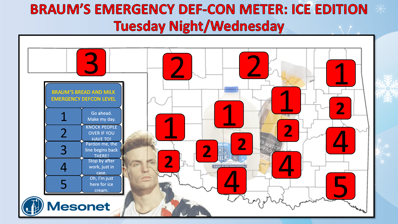
Here's a quick summary of today's Ticker, paraphrased from a million "Law and
Order: SVU" viewers: "WE DON'T MESS WITH ICE!"
Oklahoma ice forecasts...they're the 4-way stop of forecast model output. You
wait, you look, somebody else looks, they wait, somebody else looks at you, you
look at them, until eventually everybody's just looking at each other.
What, you want more roundabouts? Have you SEEN Okies maneuver a roundabout? It's
not a pretty sight.
Back to our 4-way stop...eventually, somebody has to go to get the ball rolling.
That's sort of still what we're seeing with the forecast model output, trying to
determine not only the surface temperature, which is key, but also that vertical
temperature profile, which is even keyer (work with me...words not good at).
This overused graphic on the Ticker tells the story of how that vertical
temperature profile run the Bartertown of winter precipitation type.
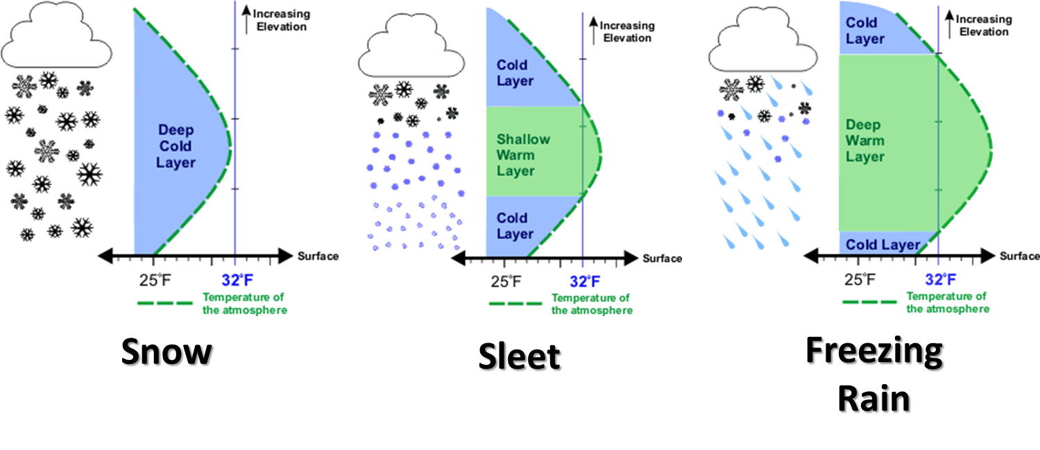
Someday we should update that graphic, just as soon as we figure out how to
break the law...of thermodynamics.
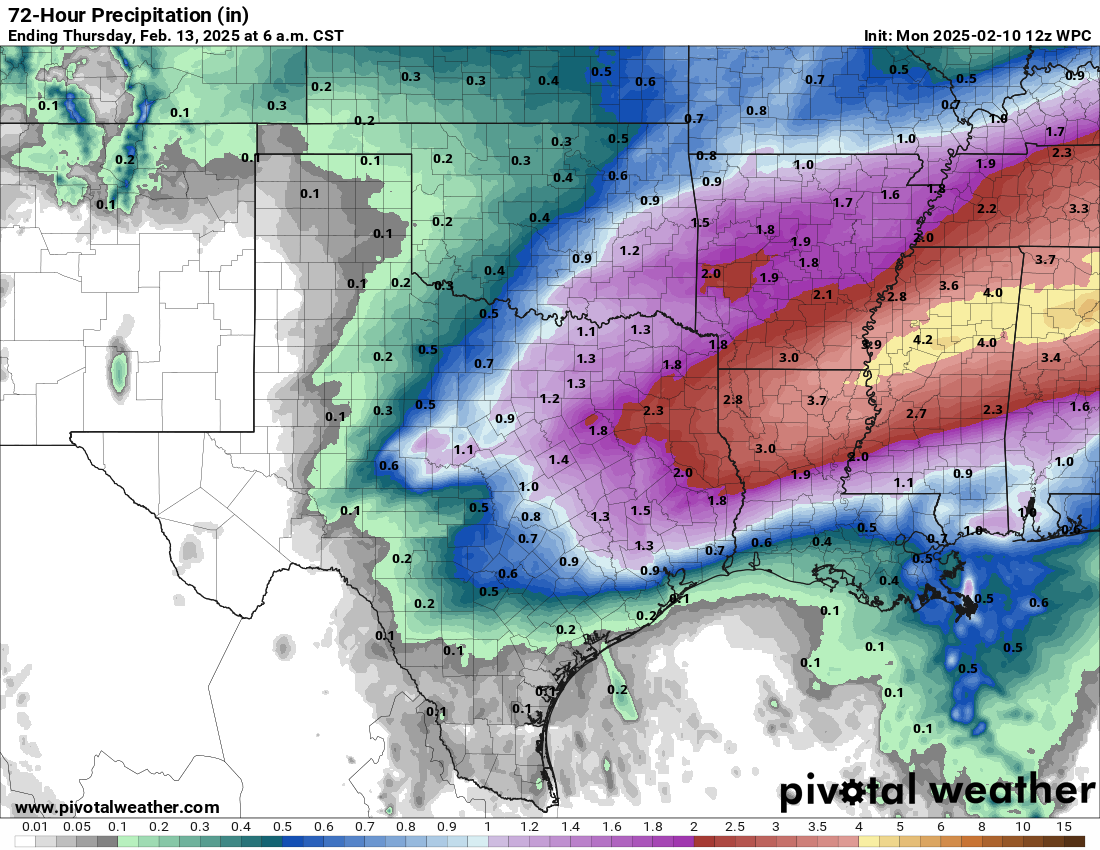
But where do those delineations occur? You get a deep warm layer above and a
shallow layer of freezing near the surface, you get freezing rain (much more
efficient at accumulating ice if you're closer to 28 as opposed to 31 or 32...
another key).
Shrink that warm layer above and expand the cold layer and any snow that formed
in the cold layer above will melt, as with the freezing rain scenario, but if
falls long enough in the freezing layer below to form a ball of ice...sleet.
Get rid of the warm layer above and any snow that forms stays as snow all the
way to the ground.
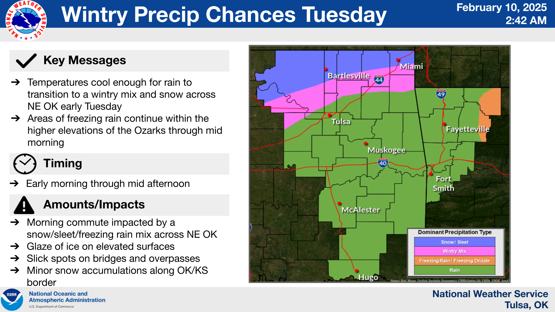
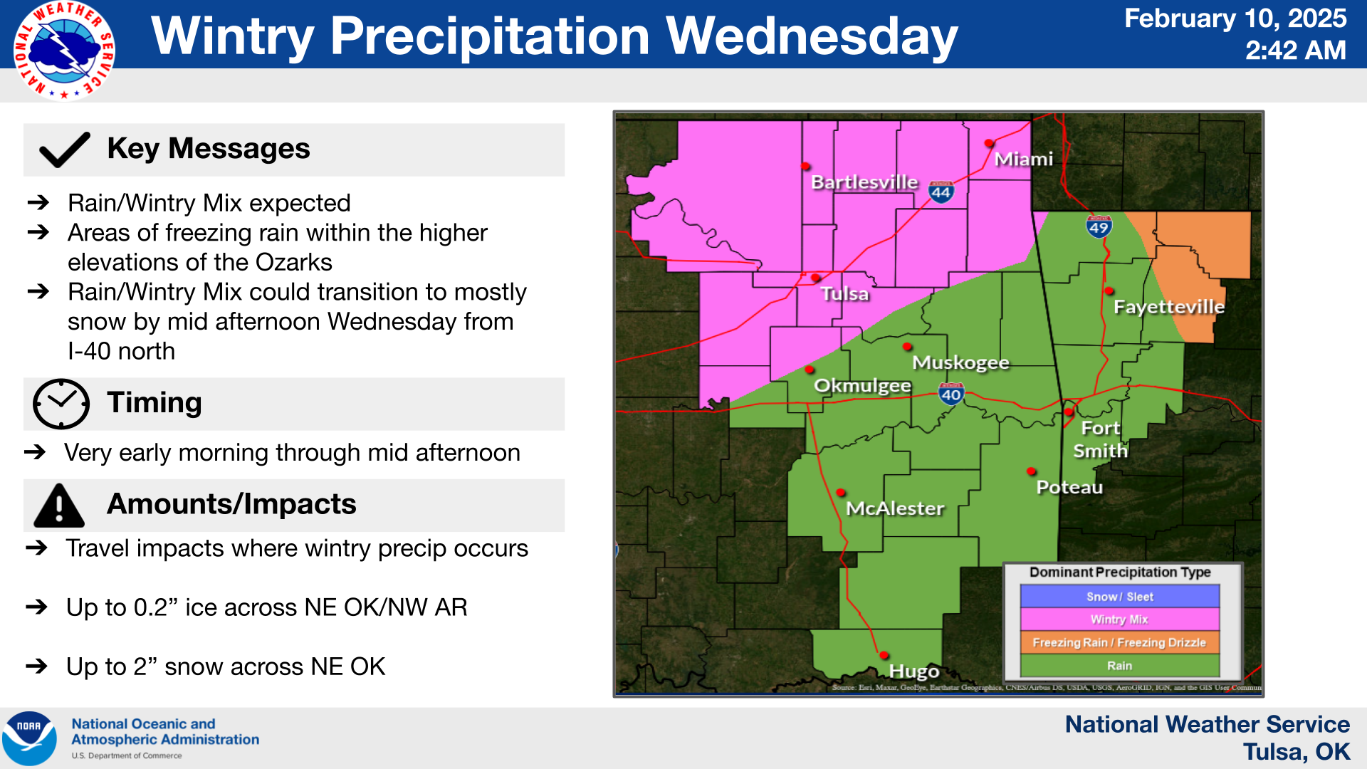
But we should see all three of those scenarios from left to right, north to
south (somewhere around the I-44 corridor, give or take 50 miles). More snow
up to the NW, maybe 2-3 inches, then some sleet, then a corridor of freezing
rain possible right along that I-44 corridor (again, fuzzy boundaries). The
worst possible scenario is ice, but even worser (Okie to English dictionary:
"more worse") is snow on top of ice. I did leave that NW corridor at a "2" on
the DEFCON scale because of that possibility, but all of this is still very
conditional on where those fine-line differences in temperature are in the
forecasts. The worst of it will be late Tuesday night into Wednesday afternoon,
especially that Wednesday morning right around rush hour.
Not as important in Gotebo as OKC and Tulsa, but still significant nonetheless
if you're out driving in it.
Here are the tales from the real experts.
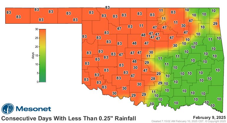
So that's a whole lot of uncertainty with a couple of days or so to go, but
that's winter forecasts for ya. What we do know is that we need moisture. Things
are getting desperate (when are they not?) in parts of the state as those numbers
on the consecutive days map continue to grow.
Keep up with the latest forecasts from your local NWS office and favorite media
source.
And get to Braum's sooner, rather than later!
Gary McManus
State Climatologist
Oklahoma Mesonet
Oklahoma Climate Survey
gmcmanus@ou.edu
February 10 in Mesonet History
| Record | Value | Station | Year |
|---|---|---|---|
| Maximum Temperature | 94°F | BEAV | 2017 |
| Minimum Temperature | -31°F | NOWA | 2011 |
| Maximum Rainfall | 2.81 inches | IDAB | 1998 |
Mesonet records begin in 1994.
Search by Date
If you're a bit off, don't worry, because just like horseshoes, “almost” counts on the Ticker website!