Ticker for December 5, 2022
MESONET TICKER ... MESONET TICKER ... MESONET TICKER ... MESONET TICKER ...
December 5, 2022 December 5, 2022 December 5, 2022 December 5, 2022
I'm dreaming? YOU'RE dreaming!
By my count, we're 20 days out from Christmas, or a Climatologist's Dozen. Sure, I
just made that up, but why should bakers have all the fun? And a Climatologist's
Dozen adds 8 days, because that's just how cool we are.
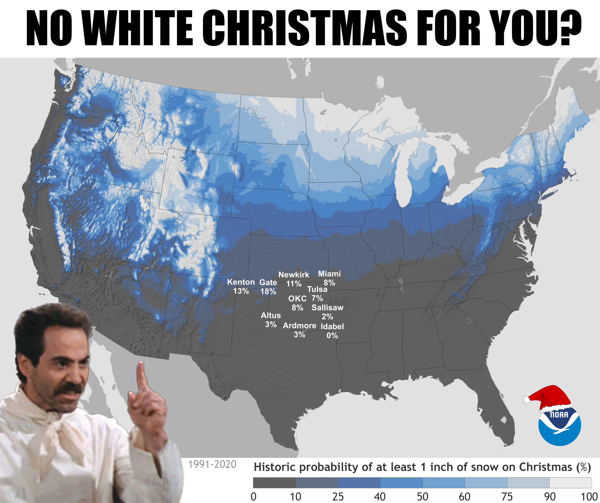
The map you see above is the percent chance that any location in the U.S. will see
at least an inch of snow on the ground on Christmas Day, based on the 1991-2020
normals from the National Centers for Environmental Information (NCEI). And it
tells us something we all knew already...most places in Oklahoma have what could
aptly be termed "negligible" odds for a white Christmas. Looks like Gate up in
far eastern Beaver County has about the best odds (again, based on data from
1991-2020) at 18%. If you're in Idabel?
Don't bother.
But wait, Idabelians (Idabelites??), this is just climatologically speaking! Right
now, if we were trying to forecast snowfall for the state, we'd stick to
climatology (which we're doing now). But soon, maybe in the next week or so, we
can switch over to fantasy-cast territory and start looking at what the medium-term
outlooks are putting out, and also the very fringes of the modeled output.
Right now, as far out as we can go (to about Christmas week) on that output on
our old friend the Fantasy-Cast giant GFS (American model), we see zilch for
not only Oklahoma, but most of the Southern U.S. Not a shocker there.

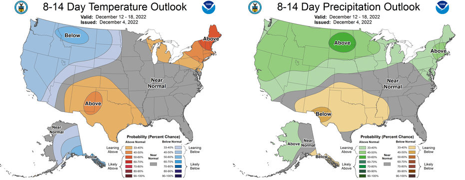
And the CPC 8-14 day outlooks aren't much help either.
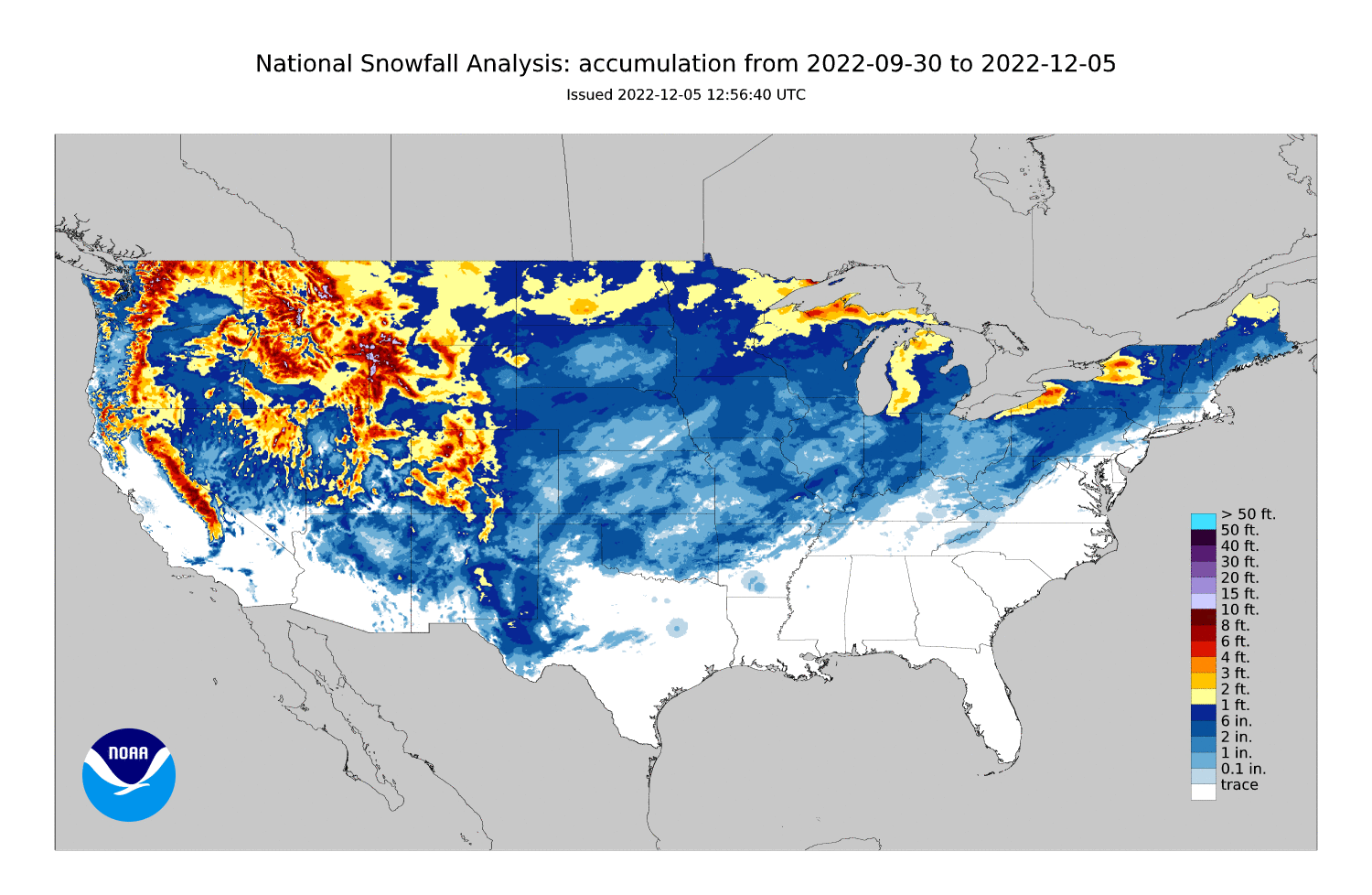
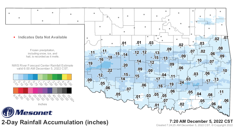
And while we're had a good dusting to more than 5 inches across much of the
state, that's also not a good indication of our chances on Christmas Day.
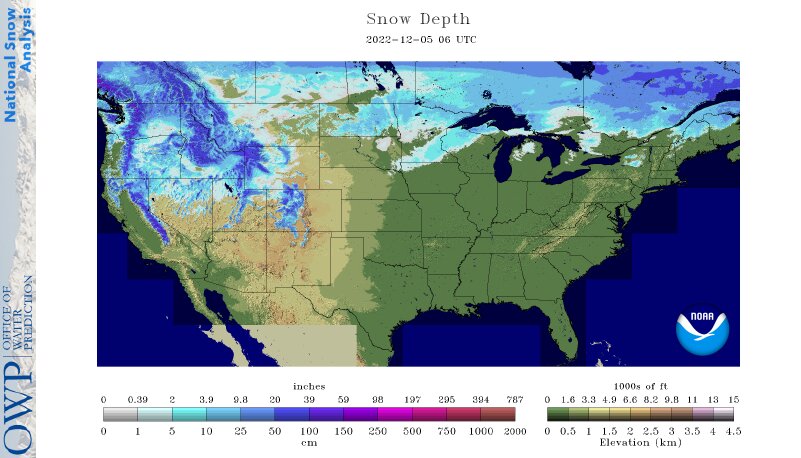
And if Christmas Day was TODAY, that'd be really really weird because today is
the 5th...but if we somehow moved Christmas Day to today, most of the country
would have what we normally get in Oklahoma...a yellow-ish brown Christmas.
So right now, based on climatology, you generally have a 5-10% chance across
the northern half of the state for a White Christmas (at least an inch of snow
on the ground). Lower than that across southern Oklahoma. Climatology rules our
forecasts (probably more apt to call it an "outlook"). Then, as we get withing
7-10 days, we can start to call it more of a weather forecast as the then-current
weather patterns start to take over.
If you want to check out the odds closest to you, have some fun here with
NCEI's interactive White Christmas odds map.
https://tinyurl.com/53vtc4pr
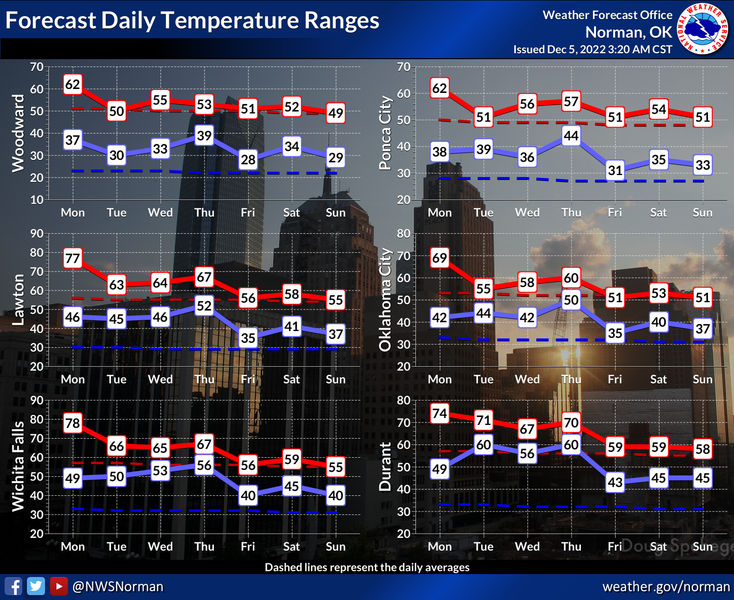
So how about our current weather? Well, up and down like a roller coaster, and
as I said back last week...consistently inconsistent enough to be boring,
because we're just oscillating back and forth before and after cold fronts
around 50 degrees or so (i.e., 45 degrees one day, 60 another day, back to 45
again, back to 60 again). Now that's over-simplified, but you're reading the
King of Simple! So expect some warmth today, then a cold front, then some rain,
then another cold front, then warmth again, then some more rain on the weekend,
etc. etc. We can't seem to match up the really cold air with the moisture to
give us something a bit more memorable other than cold rain (which is welcome
nonetheless). Heavy rains are possible across SE OK.
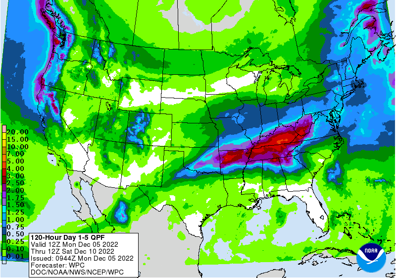
We've had a decent dose over the weekend across southern OK.
By the way, for today's highs, add a couple of climatologist's dozens to
those high temperatures.

Final Note: I purposefully didn't mention the Christmas Eve blizzard of 2009
until now...didn't want to lump that in with the climatological odds. Yeah
I remember it...I WUZ THERE!
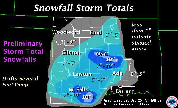
Sometimes the fun is in overdoing it, right? You can read NWS Norman's summary
of that Weather-Outside-Was-Frightful time here:
https://www.weather.gov/oun/events-20091224
Gary McManus
State Climatologist
Oklahoma Mesonet
Oklahoma Climatological Survey
gmcmanus@mesonet.org
December 5 in Mesonet History
| Record | Value | Station | Year |
|---|---|---|---|
| Maximum Temperature | 84°F | MANG | 2021 |
| Minimum Temperature | 0°F | KENT | 2013 |
| Maximum Rainfall | 1.55″ | BIXB | 2021 |
Mesonet records begin in 1994.
Search by Date
If you're a bit off, don't worry, because just like horseshoes, “almost” counts on the Ticker website!