Ticker for September 16, 2022
MESONET TICKER ... MESONET TICKER ... MESONET TICKER ... MESONET TICKER ...
September 16, 2022 September 16, 2022 September 16, 2022 September 16, 2022
La NiNOOOOO!
Sorry so short today, but that's genetics for ya. Well, for me, and maybe also
for you. No hair jokes today, because my hair is a joke already.
So why bug you today? Well, I couldn't let you get off for the weekend until I
gave you the good (bad) news about our tropical friend, the El Nino/Southern
Oscillation. Let's call it ENSO for short. As you might have heard, we are
currently in La Nina conditions in the equatorial pacific, and those conditions
are expected to persist for at least through mid-winter, and possibly through
winter into early spring.
Why is it important? Well, as we've explained in the Ticker many times, La Nina
can be quite the jerk in how it influences our weather. In a nutshell, it CAN
bring us warmer and drier than normal weather for the cool season...think October
through April. It doesn't ALWAYS do that, but it certainly tilts the odds towards
those outcomes.

And for a bit more info on La Nina, so I don't redundantly repeat myself, or
say something I've already said twice (get it?), check out one of the many
Tickers I've written on the subject:
https://ticker.mesonet.org/select.php?mo=09&da=16&yr=2020
Those correlations are stronger to our south (enjoy, Texas!), but we get caught
up in that signal more often than not. We don't have much info to work on when
it comes to triple-dip la ninas. This is only the third time since accurate
records have been kept starting in 1950 that a third straight cool season with
la nina has occurred, and the first that hasn't followed a strong El Nino. The
previous two triple-dips occurred from the winter of 1973-74 to the winter of
1975-76, and another from 1998-99 through 2000-01.
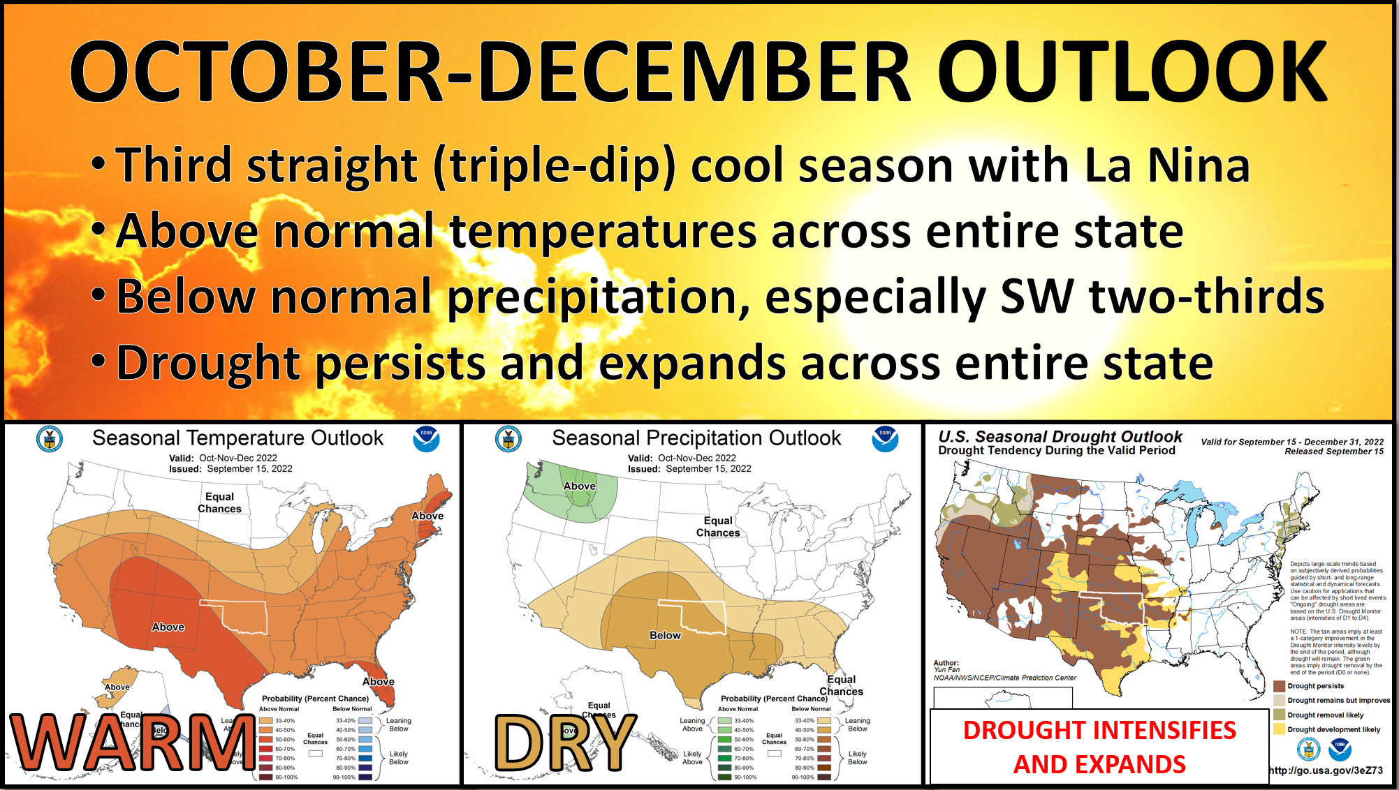
But we can also see the impacts of La Nina in October as well, in this 4-plot of
the October and then Oct-Dec outlooks.

Why do I suddenly have a craving for ice cream?
At any rate, the outlooks above show the result of the phenomenon, with
increased odds of above normal temperatures and below normal precipitation.
Now here's a caveat, and it's important: WENDY'S SHOULD NEVER HAVE REPLACED THE
VANILLA FROSTY WITH STRAWBERRY!
I mean, can't we have both? But here's an even more important caveat: JUST
BECAUSE THE ODDS ARE TILTED TOWARDS WARMER AND DRIER DOESN'T MEAN THE ODDS FOR
NEAR OR ABOVE NORMAL PRECIP AND BELOW NORMAL TEMPERATURES ARE ZERO!
They're just a bit lower. Yeah, sorry for shouting. And these outlooks show
the average outcome over the entire three-month period for broad areas. They
don't show the day to day weather, or for single locations. So like in past
La Ninas, we could AND WILL still see snow, ice, freezing weather, and all the
other glories Oklahoma weather has to offer.
So there you go. Now I wonder how much a triple-dip chocolate chip ice cream
cone is at Braum's?
Gary McManus
State Climatologist
Oklahoma Mesonet
Oklahoma Climatological Survey
gmcmanus@mesonet.org
September 16 in Mesonet History
| Record | Value | Station | Year |
|---|---|---|---|
| Maximum Temperature | 102°F | WALT | 1997 |
| Minimum Temperature | 37°F | KENT | 2012 |
| Maximum Rainfall | 3.52 inches | BURB | 2013 |
Mesonet records begin in 1994.
Search by Date
If you're a bit off, don't worry, because just like horseshoes, “almost” counts on the Ticker website!