Ticker for September 13, 2022
MESONET TICKER ... MESONET TICKER ... MESONET TICKER ... MESONET TICKER ...
September 13, 2022 September 13, 2022 September 13, 2022 September 13, 2022
Fall Wars

He who controls the pumpkin spice, controls the universe!
Yikes, what a faux pas...combining "Dune" nerd-itry with "Star Wars" nerd-itry.
Well, I didn't mention Star Wars there, so I guess I combined it with pumpkin
spice nerd-itry, which probably exceeds even "Star Trek" nerd-itry!
And oh by the way, "nerd-itry" isn't even a word...I invented it.
Now we settle into at least 9-10 days of hot, dry September weather, and we
really didn't need it either. The heat actually started yesterday. Now I'm gonna
anger some folks, but gain favor with others, in that I think the heat we had
yesterday was entirely pleasant. With the dry air, not only did it allow you to
cool off a bit more efficiently (latent heat stuff...I could tell ya but then I'd
have to bore ya), but as the sun went down the air was deliciously comfortable,
very reminiscent of the dry air in the High Plains in Buffalo (no, not THAT
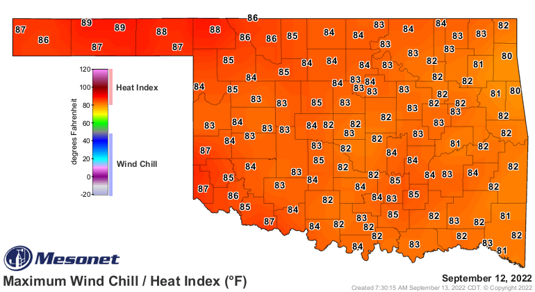
Buffalo...THAT Buffalo) that I grew up with. Notice the high temperatures
yesterday, for instance, and then look at how the maximum heat indexes were
several degrees cooler.

This is the way it's gonna be for awhile. It will feel blast furnace-like
over the next week, but that's much more doable than the pressure cooker heat
of our humid June, July, and most of August. Now there will be some moisture
return this weekend, possibly, and a slight chance of rain, but we're MOSTLY
gonna be just hot and dry.

Now here's where it gets interesting.
No, not my writing. HAHA! Good one.
(I heard that)!
No, the weather gets interesting, with the possibility of a chance in our
weather pattern next week. Some model output (some meteorologists call it
"THE DATA") shows a large upper-level trough moving over us from the Western
U.S. and a return to very fall-like conditions, AND RAIN. Other models show
persistent ridging and heat.
So until then, we'll let the models battle it out on the chances for a return
to fall next week. If not, we'll have to rely on the State Fair.
Let that simmer awhile.
Gary McManus
State Climatologist
Oklahoma Mesonet
Oklahoma Climatological Survey
gmcmanus@Mesonet.org
September 13 in Mesonet History
| Record | Value | Station | Year |
|---|---|---|---|
| Maximum Temperature | 109°F | WALT | 2011 |
| Minimum Temperature | 40°F | NEWK | 2014 |
| Maximum Rainfall | 5.53 inches | TULL | 1998 |
Mesonet records begin in 1994.
Search by Date
If you're a bit off, don't worry, because just like horseshoes, “almost” counts on the Ticker website!