Ticker for August 9, 2022
MESONET TICKER ... MESONET TICKER ... MESONET TICKER ... MESONET TICKER ...
August 9, 2022 August 9, 2022 August 9, 2022 August 9, 2022
Right turn, Clyde

The late 1970s was a grand time for movies. You had "Alien" in
1979, a breakthrough film in the realm of both horror and sci-fi, made even more
bold by having a woman in the lead role as heroine (other than the alien itself,
of course).
"Apocalypse Now" also came in 1979, the end to a remarkable decade for Francis
Ford Coppola in which he made both the seminal gangster masterpiece ("The
Godfather") and war film of the decade.
"Close Encounters of the Third Kind" came in 1977. Start with the tone.
(Pinkish-red) – D. Up a full tone. (Orange) – E. Down a major third. (Purple) – C.
Down an octave. (Yellow) – C (an octave lower). Up a perfect fifth. (White) – G.
Need I say more.
"Superman" (1978). "Halloween" (1978). "Kramer Vs. Kramer" (1979).
"Star Wars" (1977) -- The Granddaddy of them all. Deny it and be wrong!
And, oh yeah, a little masterpiece of a gem about a bare knuckled fighter who
roams the country picking up cash for underground fights in pursuit of his
white whale -- Tank Murdock, his elderly foul-mouthed Mom, his brother and
sidekick, Orville, AND AN ORANGUTAN CALLED CLYDE!!
"Everywhich Way But Loose." It was followed up in 1980 with an entertaining
but lesser sequel "Anywhich Way You Can," but as in most cases, the original
was the best.
What does this have to do with the weather? Well, nothing much, really, I just
wanted to talk about late 1970s movies. However, "right turn Clyde" is what
we MIGHT (and that's a big might, still firmly in fantasy-cast territory) be
seeing in our weather patterns. I know the above doesn't show any below normal
temperatures, but it would definitely be a start to shrink that heat dome
that has plagued us for most of the summer down to a more manageable level. It
puts us closer to the "near normal" odds category, which for later into August
is still hot, but it ain't HOT like the HOT we've been seeing.
Yeah, say "HOT" one more time, right?
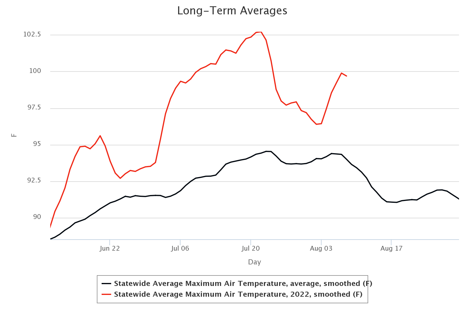
You can see from the graph there that highs in the mid- to late-August
time frame are still in the 90s according to the Mesonet's statewide
averages from 2007-2021 (black line), but what we've been seeing are temperatures
5-10 degrees above that consistently since June 10. So the trick is to get
rid of the heat dome (flatten it, move it west or east, anywhere but overhead)
to allow more powerful cold fronts to slip in and with them a chance of rain.
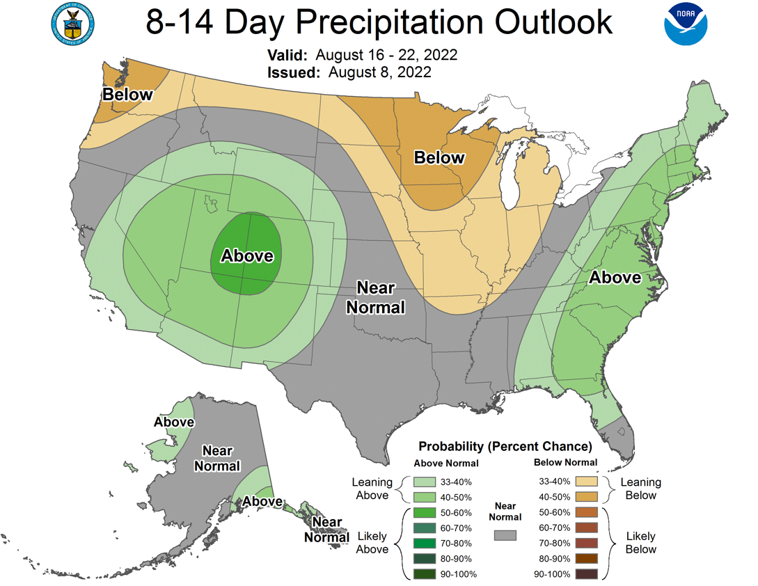
The rain outlook for that same time frame is also looking a bit better with
"near normal" odds again being prevalent next week. Again, at that point in
August we're not talking bigtime rains according to the Mesonet data, but it's
better than the below normal category.
Here is the kicker, though...it still has to happen. As of right now, at best,
it's fantasy-cast territory. But even a bit of hope is better than none. Until
then, we deal with the current DISAPPOINTING cold front and the bits of rain
it's dumping here and there.
My experience with this "cold" (lol) front? Frigging hot! More heat today with
highs approaching 100 and heat index values exceeding that.

HOWEVER, we will definitely take whatever rain this front gives us, even if it's
localized.
Now, who ate my %*#& oreos!
Gary McManus
State Climatologist
Oklahoma Mesonet
Oklahoma Climatological Survey
gmcmanus@mesonet.org
August 9 in Mesonet History
| Record | Value | Station | Year |
|---|---|---|---|
| Maximum Temperature | 112°F | WAUR | 2011 |
| Minimum Temperature | 53°F | EVAX | 2024 |
| Maximum Rainfall | 3.34 inches | PRYO | 2008 |
Mesonet records begin in 1994.
Search by Date
If you're a bit off, don't worry, because just like horseshoes, “almost” counts on the Ticker website!