Ticker for July 12, 2022
MESONET TICKER ... MESONET TICKER ... MESONET TICKER ... MESONET TICKER ...
July 12, 2022 July 12, 2022 July 12, 2022 July 12, 2022
BAH!
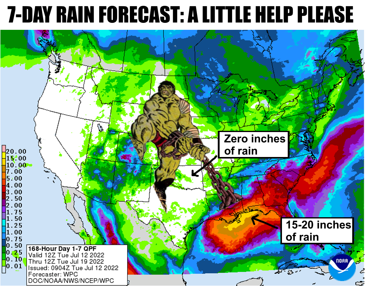
Now what good are these superheroes if they can't drag those big rains from a
few hundred miles away up into our area? Okay, maybe Hulk isn't a good one to
try that...not like you can drag clouds but you'd think at least Dr. Stra...wait,
I'm now being told that these "superheroes" aren't real, they're just CGI
generated characters in movies.
WHAT?
Sadly, it's true. We're left to the fickle nature of Mother, uhhhhhhhh, Nature,
when it comes to our weather. We have to rely on puny (BAH, HULK SMASH!! Whoa,
it's catchy) cool fronts in July to try and get some relief. It did actually
rain across NW OK last night and into this morning behind the front. No, it's
true.
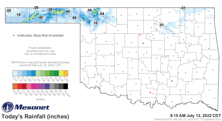
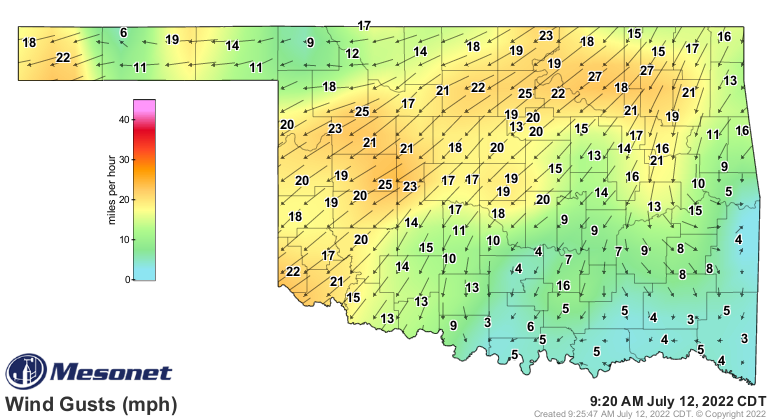
And yes, a front did actually move through overnight. Check out the winds for
proof, as well as the 24-hour temperature change.
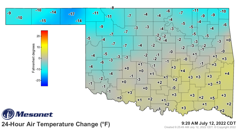
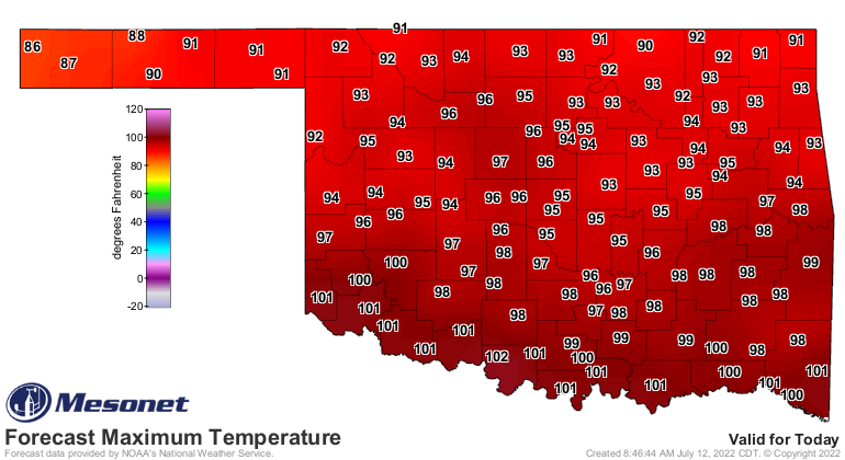
So for today, the cold front will actually keep things much below normal up
front, if things go according to plan. However, as you head south, things
get closer to normal, then above normal once again near the Red River. Then
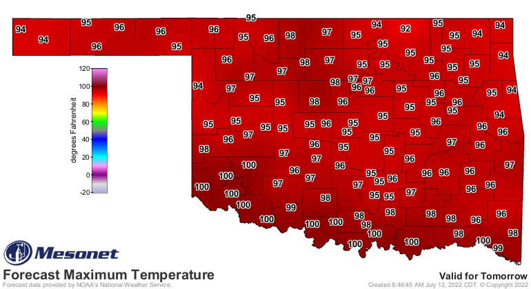
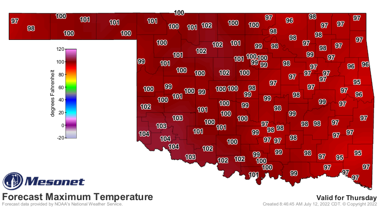
a little hotter tomorrow, then back to the fire on Thursday. Probably through
November. Just kidding. Maybe not. Maybe.
Now all this news comes off yesterday's jolting info that the previous 30 days
(June 11-July 10) were the driest such period in the last 100 years, at least
since 1921. Some folks were a bit aghast that we'd try to pass off this summer
as being drier than 2011 or 2012. Well, we're only talking a 30-day period out
of 3 months. Okay, for those summers, 6 months. But we have proof!
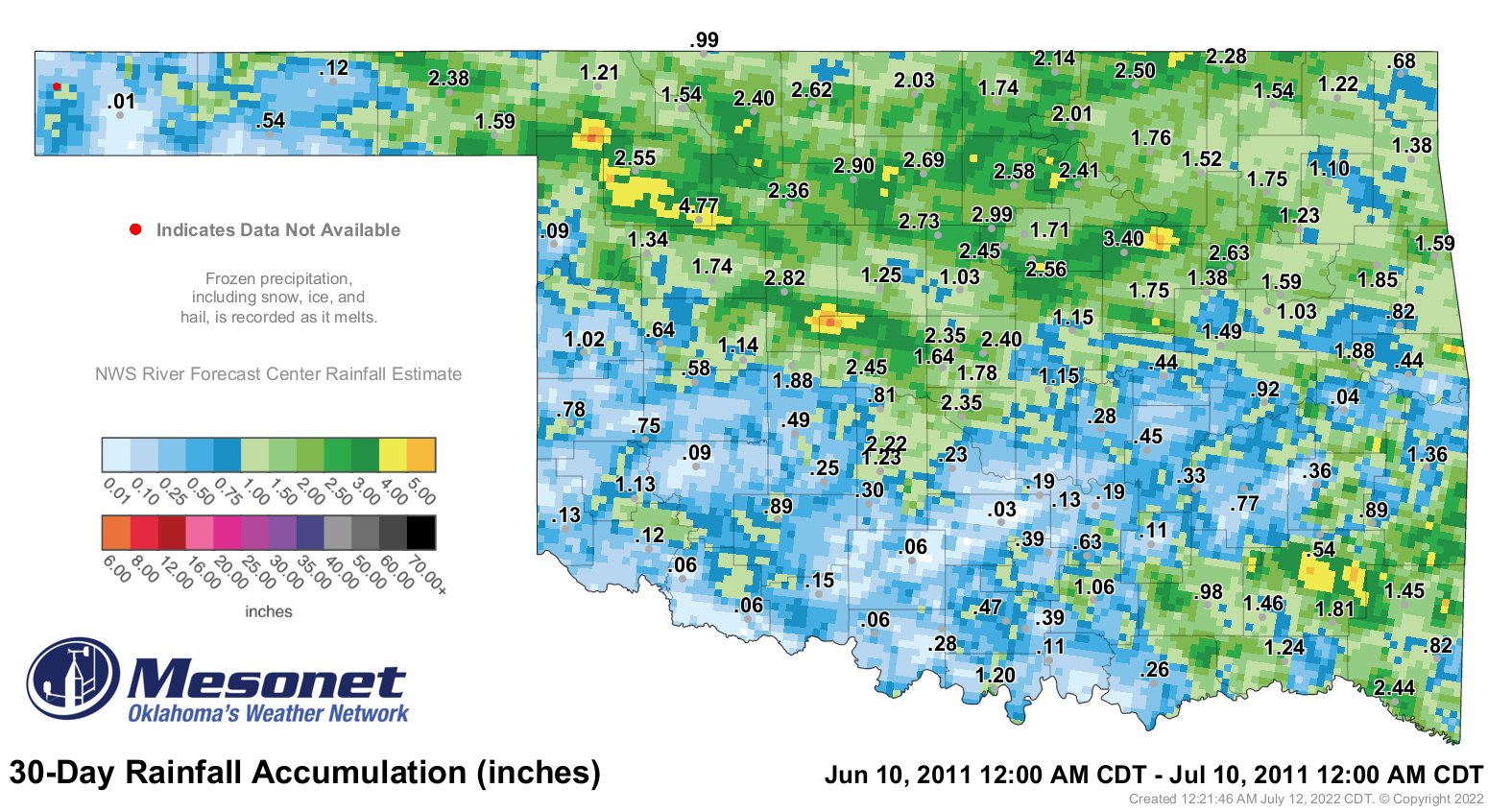
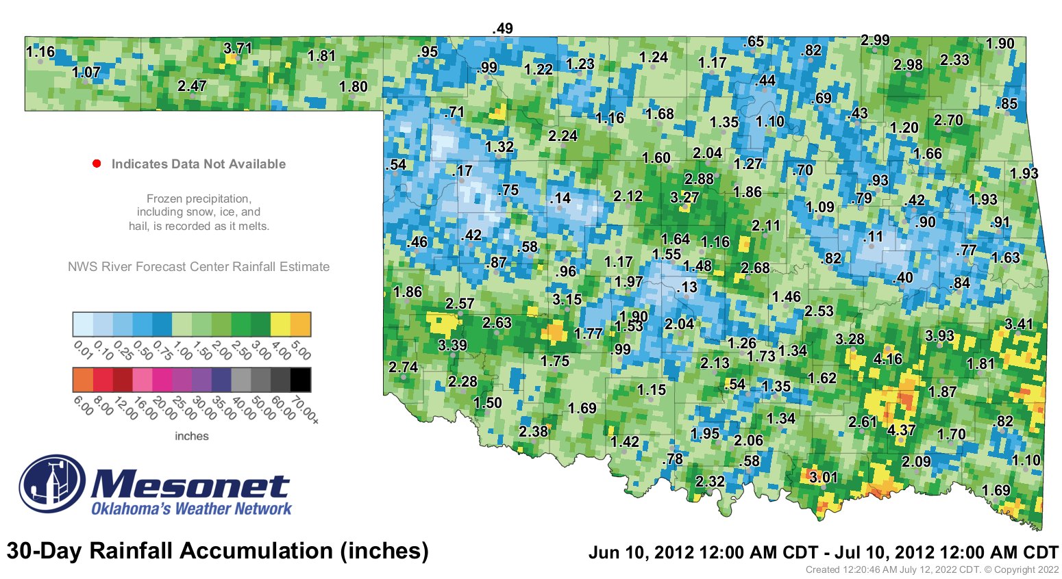
So even during the bigtime heat and drought of those two summers, it did actually
rain. This is where the temperatures come in; when they get that high, they
evaporation from so much heat can overwhelm any moisture that was received
over time. It's one of the reasons why winter's lower precip levels and summer's
higher precip levels are somewhat equal due to the temperature differences
between the two seasons. I've actually seen more soil moisture recharge with
much lower precip totals in the winter vs. much higher totals in the summer
due to the lack of evaporation and transpiration (from plants) during the cold
months.
I've also seen attack ships on fire off the shoulder of Orion. I watched C-beams
glitter in the dark near the Tannhäuser Gate. but that's a different story.
Speaking of fire, this is becoming something of a dangerous situation with our
much lower soil moisture levels, as our fire experts from Oklahoma State
tell us. Using the 16-inch plant available water data from the Mesonet as a
guide, we see that the risk for large fires--those greater than 1000 acres--is
now in the "EXTREME" category over much of the state. And "HIGH" for much of
the rest of it.

As the explainer says, "...given suitable fire weather conditions," there is a
lot of fuel out there just waiting for one of those days...one of those days
when the heat explodes and it's windy and those dewpoints plummet.
Oh, the fun things we have to look forward to if it doesn't rain soon! The heat,
the fire danger, the cracked ground, old men with white legs in shorts for
much longer.
Ahem.
Gary McManus
State Climatologist
Oklahoma Mesonet
Oklahoma Climatological Survey
gmcmanus@mesonet.org
July 12 in Mesonet History
| Record | Value | Station | Year |
|---|---|---|---|
| Maximum Temperature | 110°F | HOLL | 2001 |
| Minimum Temperature | 52°F | EVAX | 2021 |
| Maximum Rainfall | 4.44 inches | OKMU | 1996 |
Mesonet records begin in 1994.
Search by Date
If you're a bit off, don't worry, because just like horseshoes, “almost” counts on the Ticker website!