Ticker for April 12, 2022
MESONET TICKER ... MESONET TICKER ... MESONET TICKER ... MESONET TICKER ...
April 12, 2022 April 12, 2022 April 12, 2022 April 12, 2022
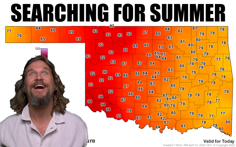
Turn it up to 100
(I'm gonna be honest here...I had a nicely written, concise Ticker almost
finished when I accidentally closed the tab on my browser...so this is the
Ticker you get instead).
Some would call that burying the lede. I know, I thought it was "lead" too, but
then again I aren't good at English. Most folks would have gone with the bigtime
fire danger we face today across the western half of the state. Others would go
with the severe weather threat across the eastern half, even though it is still
highly conditional. Not me! I go for the opposite of the old adage of "if it's
going to be cold, might as well snow." Well, if it's going to be hot (and
miserably windy), might as well hit our first 100 for the year! It's gonna be a
push to do it, but I'm betting in the face of some compressional heating in the
area of the dryline, we can do it. Here's the problem though...those high temps
are one of the very things creating a near-historic fire danger day.
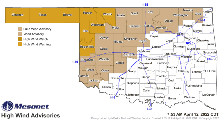
We'll see winds topping 60 mph across NW OK, and above 50 across much of the rest
of western OK. Humidity will drop to lip-cracking levels in the single digits.
I'm talking rock-hard booger values even Judge Smails' nephew Spalding couldn't
get at.
You don't get this high level of sophisticated scientific analysis anywhere else,
folks.
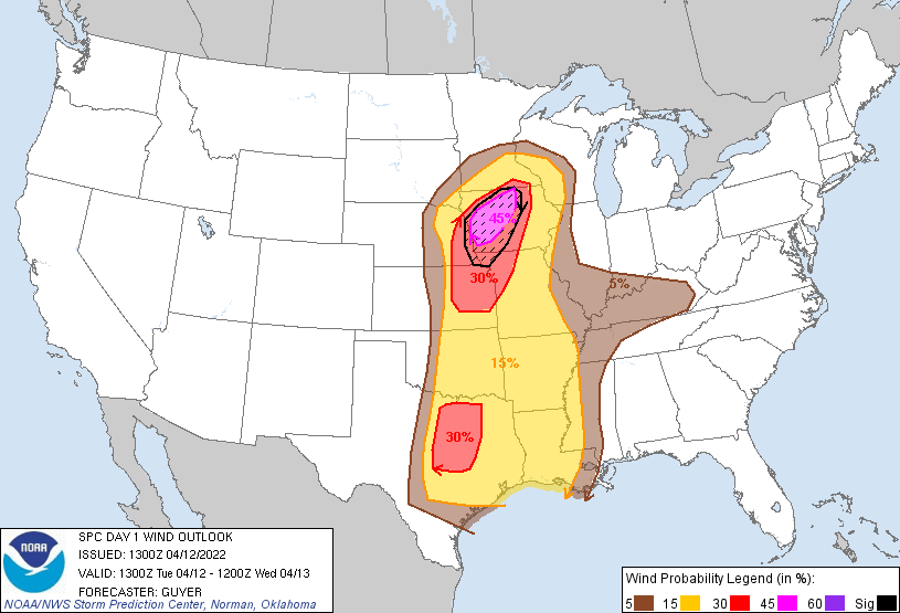
So we have high wind and red flag fire warnings for western OK, a 60% chance
of a significant wildfire outbreak across the NW, and I'm betting a lovely dust
storm across the entire area for later today.
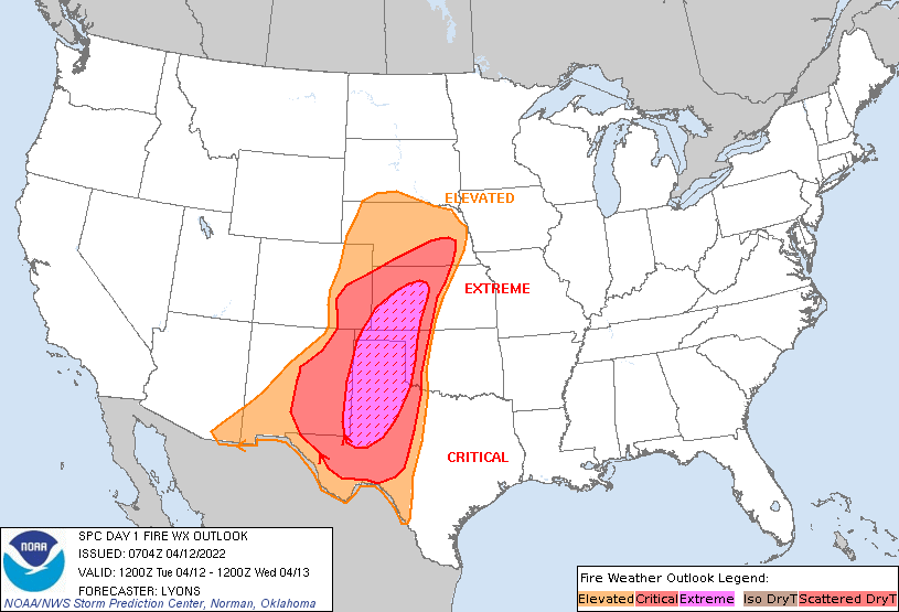
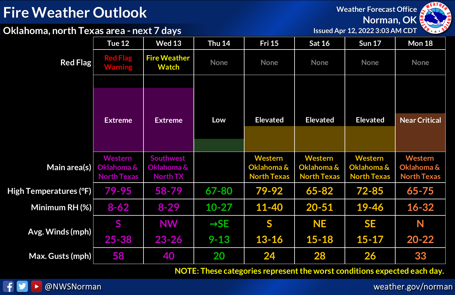

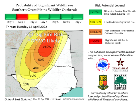
Here is again the rather ominous discussion from the OFS situation report (which
you can subscribe to here):
https://public.govdelivery.com/accounts/OKDAFF/subscriber/new?qsp=OKDAFF_1
"A potentially dangerous wildfire episode is expected over the southern
Great Plains today. Fuels and fire weather will support significant
wildfire occurrence (+5,000 acres) and wildfire outbreak potential.
In Oklahoma, the greatest concern is placed in northwestern Oklahoma and
eastern Oklahoma Panhandle where the strongest alignment in both fire
weather and fuels inputs will exist. Spatial concern will
be dependent upon placement of the dryline this afternoon where
temperatures will soar above normal, relative humidity values drop into
the low teens and southerly winds will be very strong. Rates of fire
spread on established fires will outpace suppression efforts during
peak burning conditions. An approaching cold front late this evening
into the overnight will have potential to blow out the eastern fire
flank and southern portions of going fires resulting in potential for
megafire occurrence (+100,000 acres). Burning conditions will persist
well into the evening and overnight hours, especially in northwestern
Oklahoma."
Well, that about covers the fire situation, seeing a potential for "megafire
occurrence!"
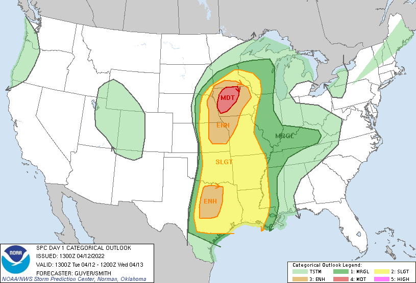
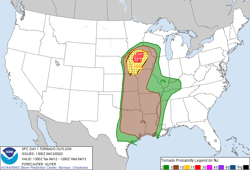
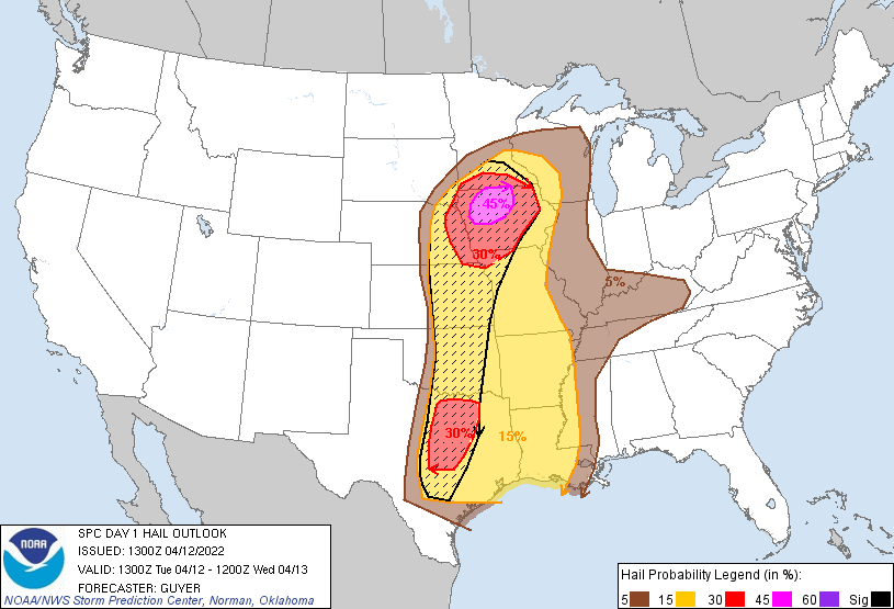
Now for the eastern half, we're just gonna drop in and see what condition out
conditional severe outbreak is in. Well, with a cap in place and a bit of
subsidence (sinking air) working for us (some would say against, I says for),
the chances for storms have dropped a bit. However, should a storm or two form,
they would likely go quickly severe with supercellular structure, and pose a
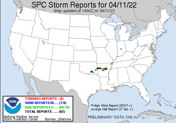
tornadic and very large hail threat. And this is exactly what occurred yesteray
down in SE OK where forecast models were poo-pooing storm development. A slew
of tornado warnings later and so much for the forecast models. Thank goodness
for the Storm Prediction Center and NWS offices for seeing the event's
possibility.
Yes, I'm very much saying this to alert you to the danger of letting your guard
down! It wouldn't shock me at all to see a storm or two go up along the dryline
and cause a bit of havoc. And if Mother Nature cries havoc, she WILL let slip
the dogs of war on us.
Caddyshack AND Shakespeare? I fear I've created something of a faux pas. Oh
well, here are the pertinent graphics from today's SPC outlooks. Don't be
complacent...these could change. Or nothing could happen at all.
The fuel will be there, with moisture surging back into the state on those
strong southerly winds.
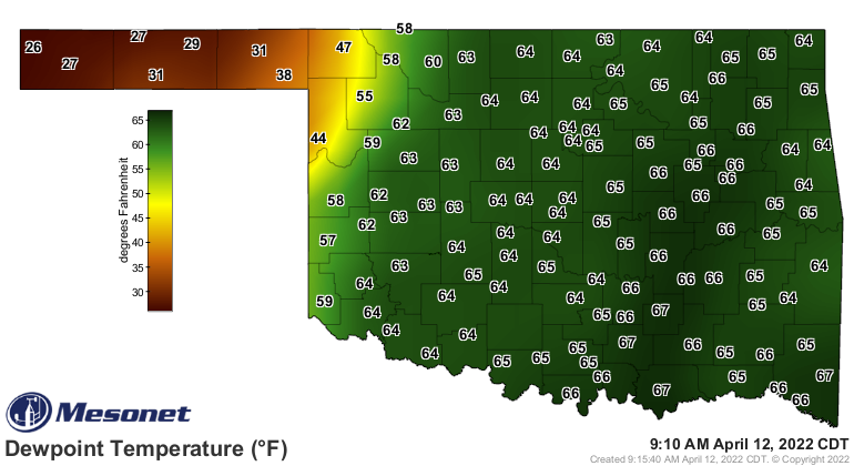
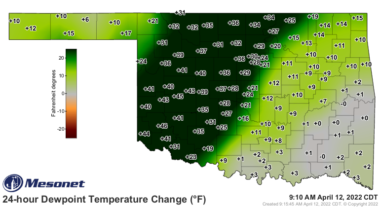
If only those dewpoints would stay that high across western Oklahoma. Sadly,
that won't be the case. So buckle up and stay safe today.
Gary McManus
State Climatologist
Oklahoma Mesonet
Oklahoma Climatological Survey
gmcmanus@mesonet.org
April 12 in Mesonet History
| Record | Value | Station | Year |
|---|---|---|---|
| Maximum Temperature | 102°F | MANG | 2018 |
| Minimum Temperature | 14°F | BOIS | 1997 |
| Maximum Rainfall | 3.14 inches | CHEY | 2015 |
Mesonet records begin in 1994.
Search by Date
If you're a bit off, don't worry, because just like horseshoes, “almost” counts on the Ticker website!