Ticker for November 8, 2021
MESONET TICKER ... MESONET TICKER ... MESONET TICKER ... MESONET TICKER ...
November 8, 2021 November 8, 2021 November 8, 2021 November 8, 2021
Be the freeze
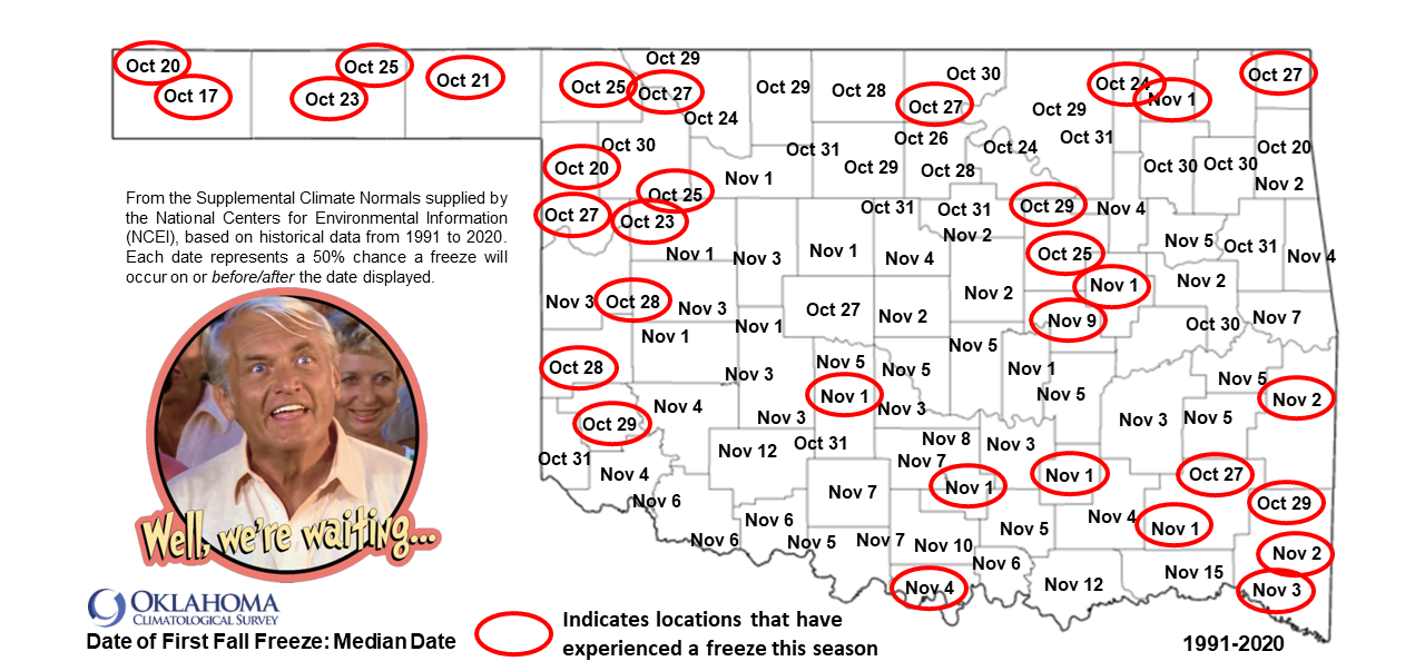
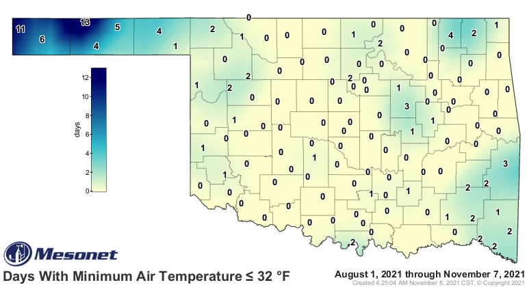
YOU'LL GET NO FREEZES AND LIKE IT! I would put fifty bucks on you getting a
freeze, but that'd lead to something gross. For the map above, there are gonna
be small geographical differences in some locations that might have already
froze, but I'm going by the Oklahoma Mesonet data as well as the NWS COOP data
(complicated by the fact that some Mesonet sites are also COOP sites, but that's
a story for another century). In other words, you might have had a freeze at your
house, but it might not be reflected on this map. Maybe you live in a low-lying
area. Maybe there isn't a station close to you. Maybe you left your freezer
door open?
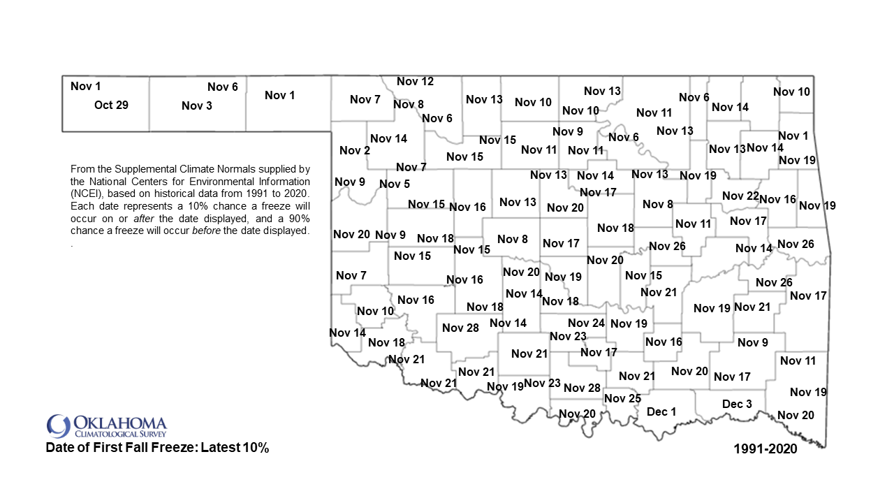
So for some folks, you've gone right past the average freeze data (actually the
MEDIAN freeze data based on the 1991-2020 data by NCEI) and will quickly be
approaching the quasi-latest freeze date, as represented here by the "latest 10%"
again based on the NCEI 1991-2020 normals data. That would mostly be across
northern OK, but there are other areas scattered about that are passed or near
their "latest" freeze date.
Good news for those gluttons for freezing weather punishment--the current warm
phase will soon pass with a cold front coming through the state on Wednesday.
We will have a front in the area today, but it's not THE cold front to cool
us down to where freezes start to scatter about all parts of the state...that's
the Wednesday front.
By Thursday morning into Friday, we'll see freezing temps again in parts of the
state, but even more so Saturday morning with another front.
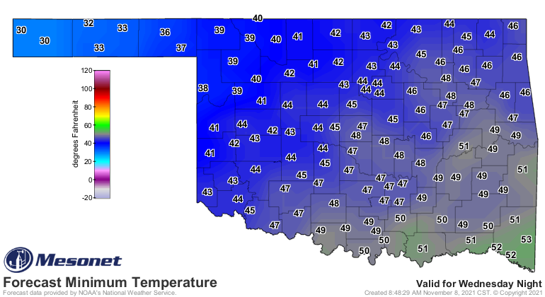
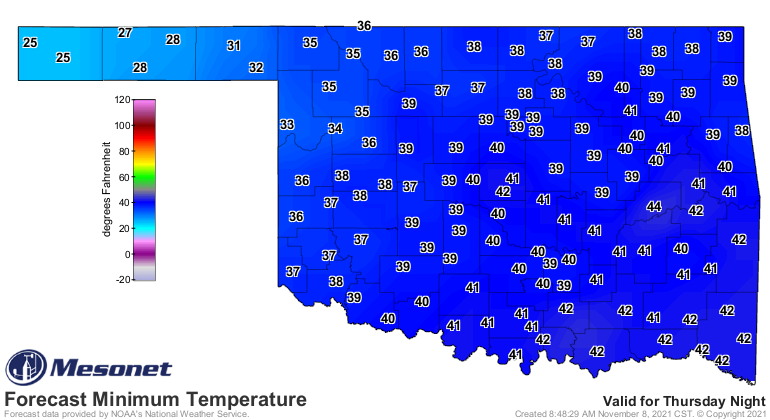
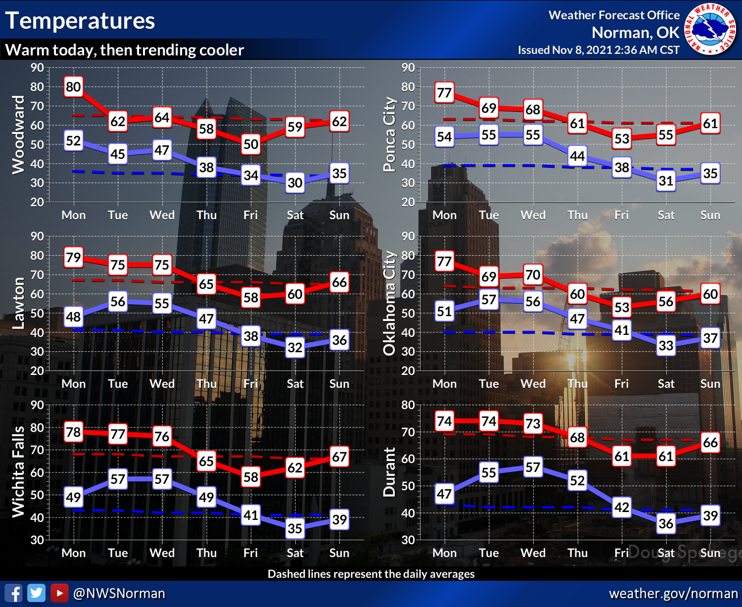
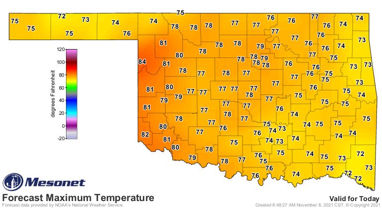
So a bit more seasonable, compared to what we saw the last couple of days (and
today) where they blasted away at record highs up in the Panhandle.
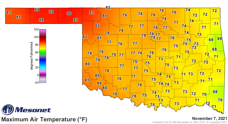
HOLY STEAMED MACKERAL BATMAN! Dang it, I never can spell mackeral. Or mackarel.
Dang it! Mackaral. Forget it, let's go with flounder.
HOLY FLOUNDER, BATMAN! Yeah, not the same oomph, but did you see Beaver hit
90 degrees yesterday? Goodness, what does that make Ward and Mrs. Cleaver? The
record high temp for Beaver on Nov. 7 was 88 degrees set back in 2009, so that
record fell, as did Hooker's 86 degrees from that year with 89 degrees
yesterday.
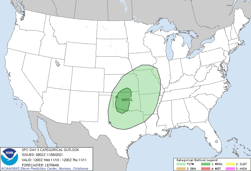
All that starts to go downhill after today, sadly, but at least we might see
a bit of moisture with that mid-week bit of weather change. Now there might also
be some inclement weather to go along with that, uhhhh, weather, but nothing
like we saw during October...a marginal risk of severe weather in the form of
some wind and hail.
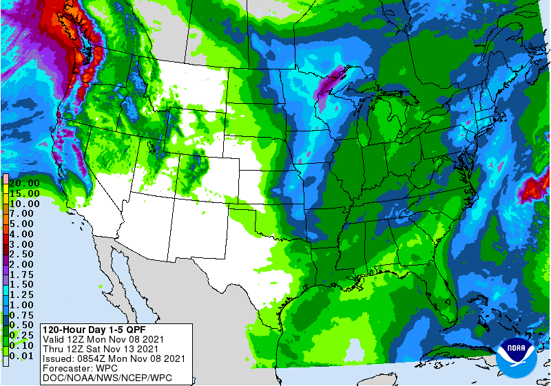
So at least the weather pattern will be active this week with a chance of
moisture...that is something we definitely need. Still no sign of a huge
outbreak of arctic air down our way. We might get a glancing blow from some
cold air that plunged into the the Southeast, but after that there is just a
hing of a big cold air outbreak Thanksgiving week, but that's in Fantasyland
forecast time...much could change before then. I know because that's also
where my full head of hair resides.
Gary McManus
State Climatologist
Oklahoma Mesonet
Oklahoma Climatological Survey
gmcmanus@mesonet.org
November 8 in Mesonet History
| Record | Value | Station | Year |
|---|---|---|---|
| Maximum Temperature | 92°F | FREE | 2006 |
| Minimum Temperature | 19°F | BOIS | 2000 |
| Maximum Rainfall | 3.96″ | TALI | 2011 |
Mesonet records begin in 1994.
Search by Date
If you're a bit off, don't worry, because just like horseshoes, “almost” counts on the Ticker website!