Ticker for October 21, 2021
MESONET TICKER ... MESONET TICKER ... MESONET TICKER ... MESONET TICKER ...
October 21, 2021 October 21, 2021 October 21, 2021 October 21, 2021
double-dipper
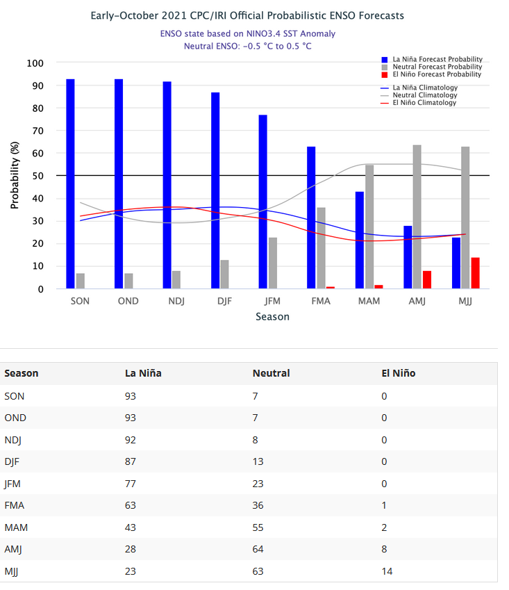
Yep, Mother Nature dipped her chip into La Nina last winter, took a bite...then
she dipped again! We have now entered into La Nina conditions in the equatorial
pacific ocean and atmosphere, and it's expected to last through the winter into
early spring of 2022. So the Climate Prediction Center has issued a La Nina
Advisory (up from the La Nina Watch previously) for that time frame. At it's peak,
a MODERATE strength La Nina is favored by the oddsmakers (i.e., the SST forecast
models and the forecasters who interpret them).
As we blabbed on and on about last year when we were faced with a possible
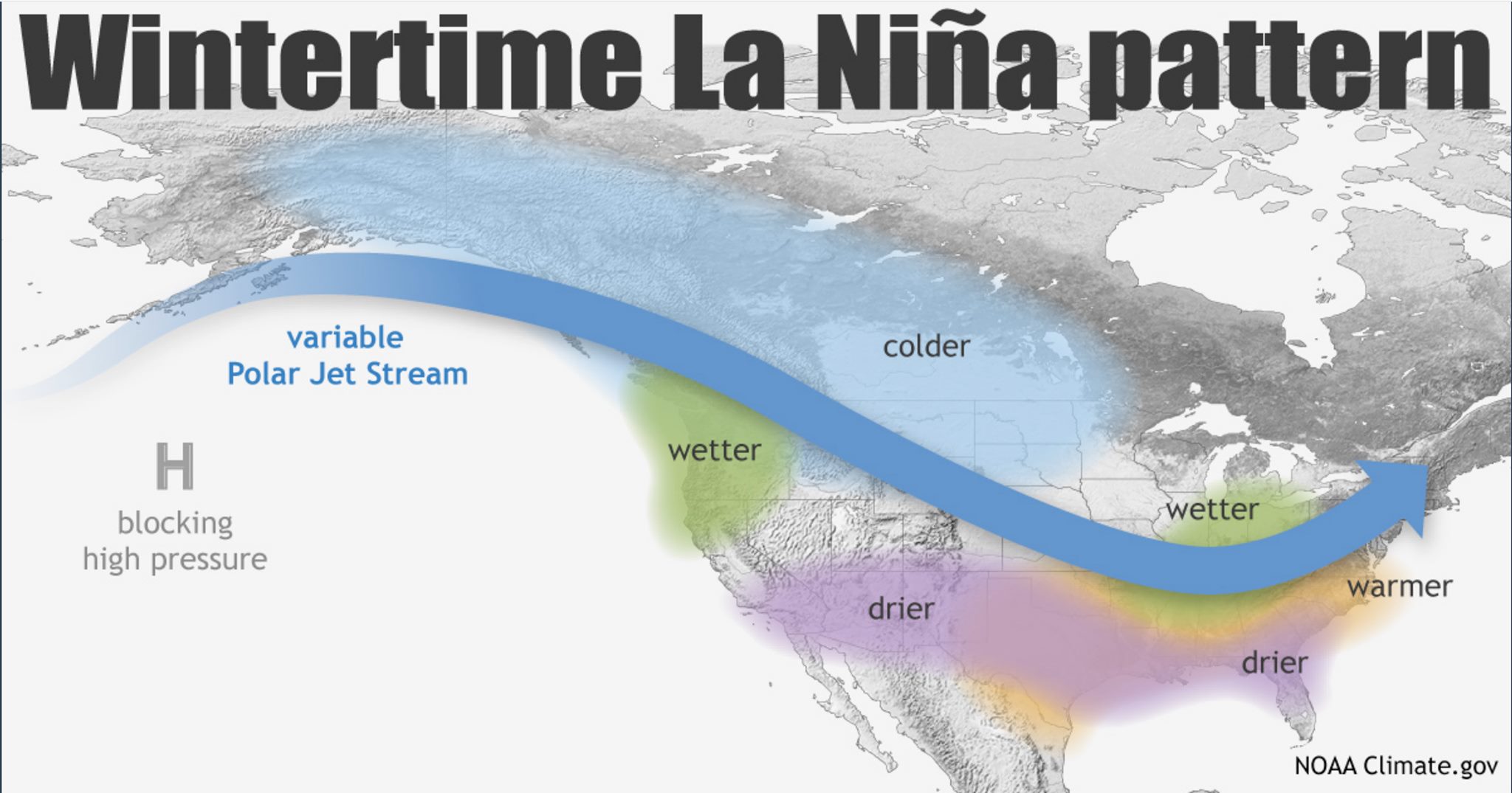
moderate strength La Nina ENSO event, that tends to bring the Southern Tier of the
U.S. (was I supposed to capitalize "Southern Tier?"...so let it be written, so let
it be done!) warmer and drier than normal weather through the cool season (say,
November-March/April'ish). This is not a definitive prediction, of course. As
we tried to stress last year (and in year's previous), this is what has occurred
ON AVERAGE OVER MANY SIMILAR EVENTS. So the odds are tilted in that direction,
but there are other influences that can overwhelm even a strong ENSO signal.
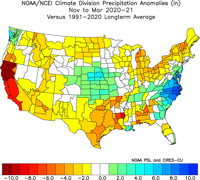
Lots of attention focused on how last year's La Nina didn't live up to its
billing, at least to a large degree. However, there was still a warm and dry
signal to be had for Oklahoma over that November-March time frame. You can see
the dry signal over the SE half of Oklahoma during last year's moderate La Nina
event.
Temperatures ended up on the warm side as well over that November-March time
frame, the 46th warmest such period since 1895 in Oklahoma. Now obviously the
DEEP FREEZEMAGEDDON EVENT OF FEBRUARY 2021 (trademarked title to some silly
fool of a State Climatologist in Oklahoma) dominated the winter headlines last
year, but again this is a cautionary tale of how seasonal forecasting works...
you can look towards the overall weather pattern on the long-term, but you
can't dig down into the details and forecast those extreme events, right? So
think of a football game where both teams slug it out defensively the entire
game but somewhere in there somebody gets a lucky block and goes 99 yards for a
TD. They win the game 7-0 in an obvious defensive struggle, but that extreme
event, the 99 yard TD, nevertheless wins the game. Yay team!
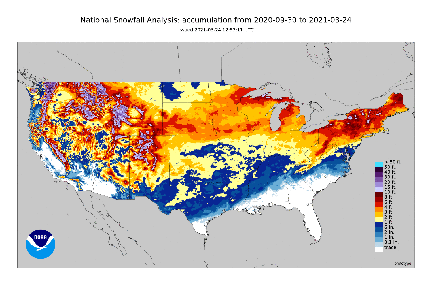
And what an extreme event that was, right? Remember the snow??
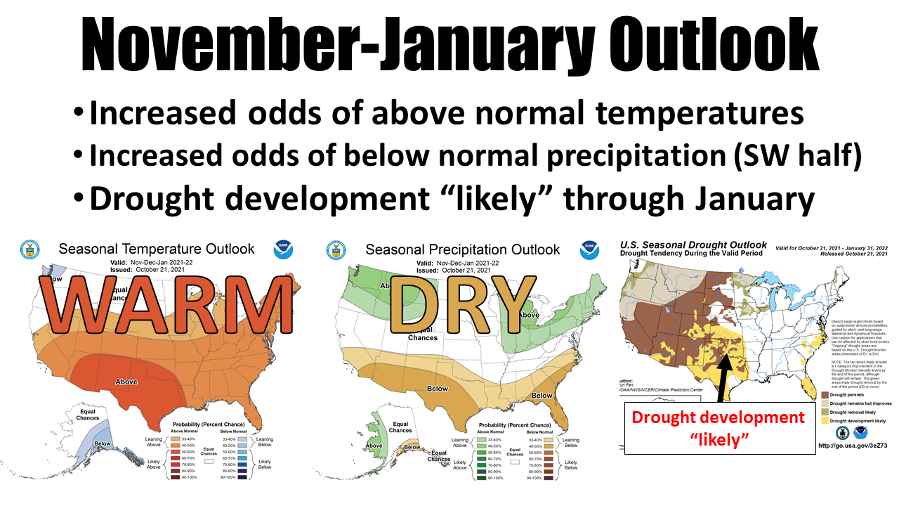
So we do see some influences on the November-January outlooks above from La Nina.
ONCE AGAIN, these impacts are simply what have been observed during La Nina
winters over many events, coupled with some model output. So what happened
during last year's La Nina, like the wetter than normal conditions over the
NW sections of the state for November-March, have no real bearing directly on
the current event, it just becomes part of the statistical averages of many
La Nina events.
I can say, however, that the weather (ON AVERAGE OVER SEVERAL EVENTS) has
tended to show a stronger drier than normal signal during the second year of
these double-dip events. Let me reiterate once again how averages work...they
point towards tilted odds favoring drier than normal conditions, but those
averages aren't pegged all the way to 100%. Meaning...there are some wet
events in there as well, of it would BE 100%, okay?
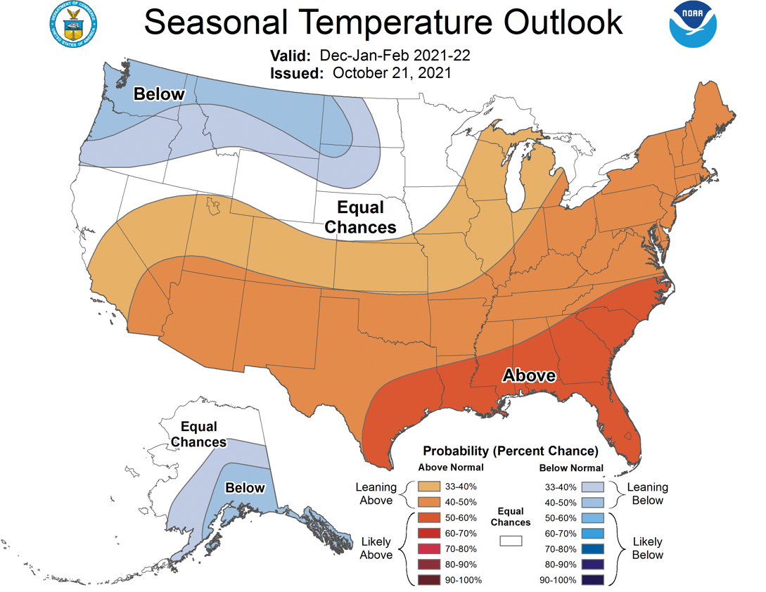
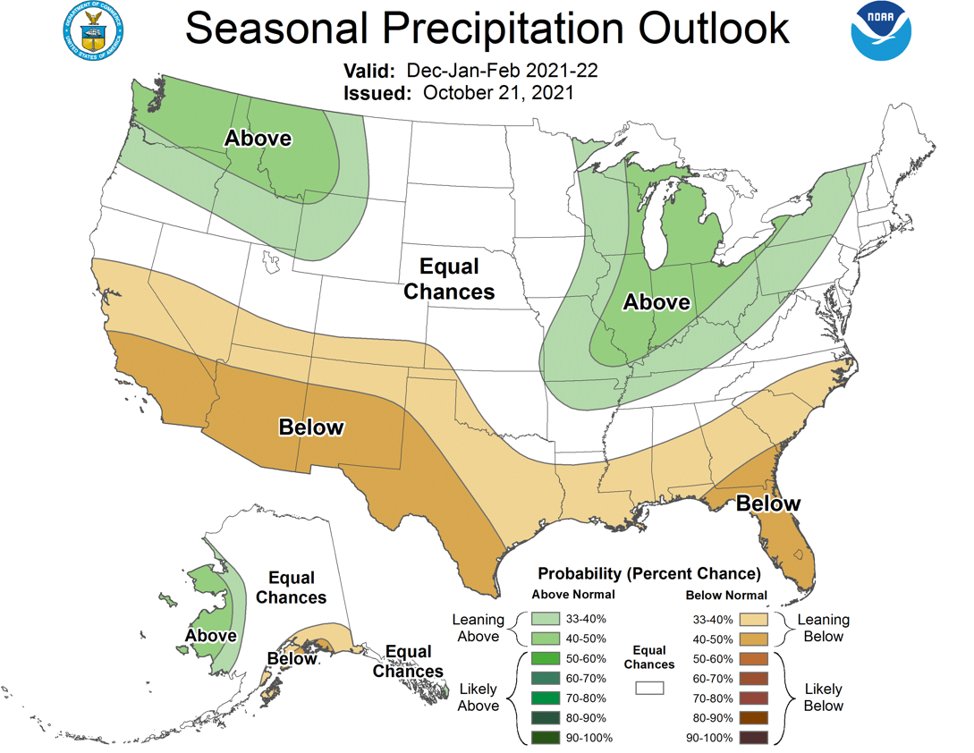
Now, on with the show this is it. We can also look at the "classic" winter
outlook from CPC--the climatological winter months of December-February. Those
show a bit more muted signal for drier than normal conditions across Oklahoma,
contained within far SW OK and the Panhandle. You can also see a bit of a
tongue of wetter than normal conditions edging down into far NE OK. This is
a classic La Nina signal with that dry area across the SW and Panhandle coupled
with that wet tongue extending down from the Great Lakes.
I know I've spent a ton talking about La Nina and averages and BBQ and
froglegs...well, maybe I was just thinking about those other things. But since
we just did all this last year, I'm gonna refer you to our big regurgitation
of all things La Nina from last year as well.
http://ticker.mesonet.org/select.php?mo=09&da=16&yr=2020
My point this year was to please understand that the presence of these ENSO
events like La Nina and El Nino do not guarantee these impacts...they merely
tilt the odds towards warm and dry, okay? That has what has occurred on average
the majority of the time over many events. Last year's La Nina never reached
"typical" status because the atmospheric coupling with the SSTs never came
fully around to creating the most typical impacts across the globe. It was
enough to qualify as an official La Nina event, but not quite enough to give
us what was forecast (outlooked?).
Now, speaking of drought (weren't we??), we have seen drought explode over the
last couple of months, but then we got a bit of a reprieve over the flash
drought conditions over the last couple of weeks with 3-4 rain events. And even
those events brought us a possible record number of October tornadoes, they
also brought us some pretty decent rains. HOWEVER, we still have drought
and abnormally dry conditions across the state due to the longer-term deficits.
Take a look at these 60-day rain stats and maps and you'll see that we're still
on the dry side over that flash drought period.
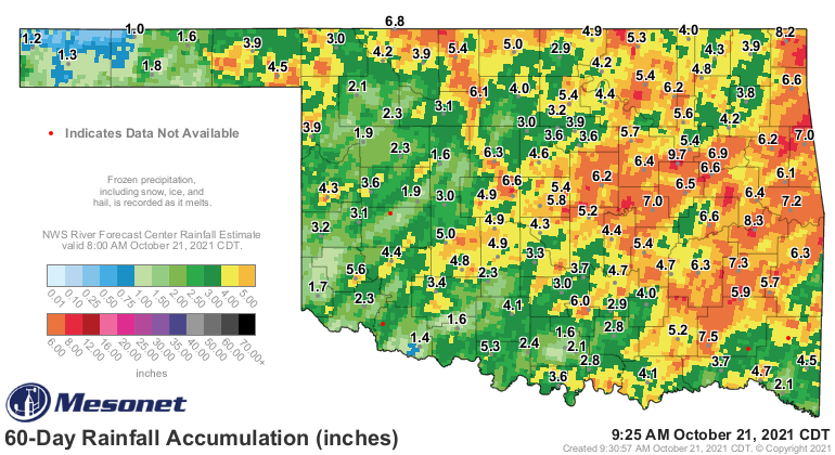
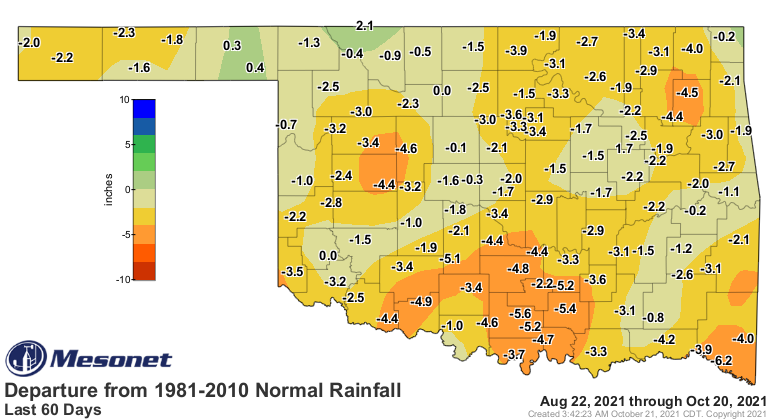
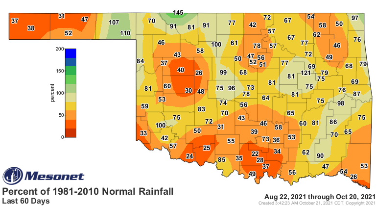
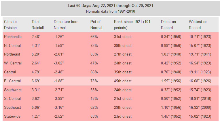
This is a lot like those seasonal outlooks...looks really dry on the longer-term,
but those extreme events still have an impact. So we alleviated some immediate
drought concerns, but we still have pressure due to those longer-term deficits.
Meaning, we could slip back into drought pretty quickly without more relief.
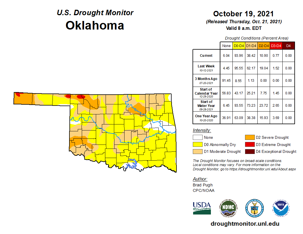
While only 38% of the state is considered in actual drought (D1-D4), 94% of the
state is considered to have AT LEAST abnormally dry conditions (D0-D4). In other
words, drought development is a concern until it rains some more. Luckily, we
do have some rain in the forecast over the next 7 days, first this weekend
and then early next week.
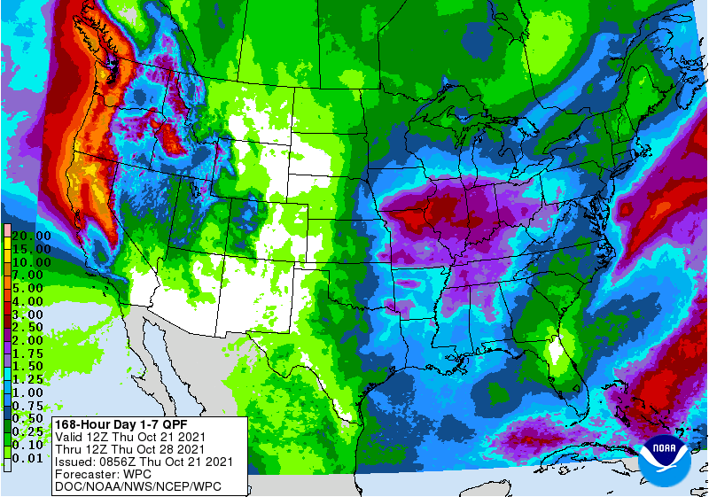
But in the medium-term, it looks again to remain on the dry and warm side.
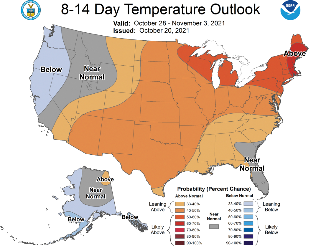
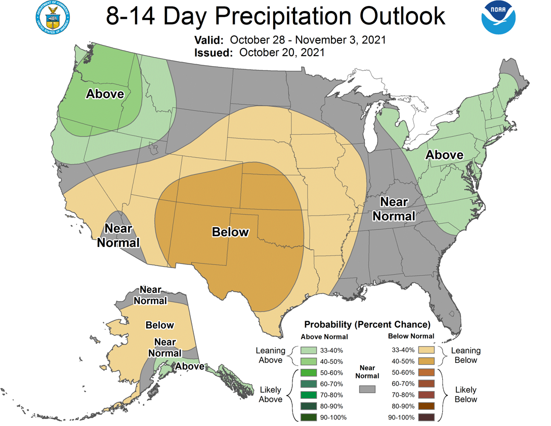
Now after that vomitus display of disparate climate and weather info, I fully
expect the coldest, snowiest, Joe Pesci-est winter on record.
Why Joe Pesci?
Why not?
Gary McManus
State Climatologist
Oklahoma Mesonet
Oklahoma Climatological Survey
gmcmanus@mesonet.org
October 21 in Mesonet History
| Record | Value | Station | Year |
|---|---|---|---|
| Maximum Temperature | 98°F | MANG | 2012 |
| Minimum Temperature | 23°F | KENT | 2019 |
| Maximum Rainfall | 5.60″ | ANTL | 1996 |
Mesonet records begin in 1994.
Search by Date
If you're a bit off, don't worry, because just like horseshoes, “almost” counts on the Ticker website!