Ticker for April 1, 2021
MESONET TICKER ... MESONET TICKER ... MESONET TICKER ... MESONET TICKER ...
April 1, 2021 April 1, 2021 April 1, 2021 April 1, 2021
Rabbit gravy
No fool here. I'm a fool 24-7, 365 days a year! HA! Nice try, though. Errr....
wait, never mind.
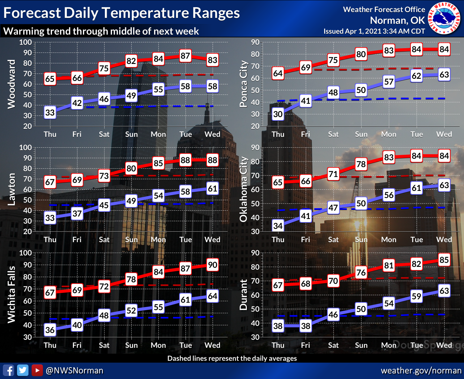
I could have led with last night's freeze instead of the Easter high temperature
forecast, but I'm so tired of cold weather, I just couldn't do it. But here is
the freeze info anyway. Most areas that froze didn't spend too long below
the 32-degree mark, but remember low lying areas (you know who you are) probably
dropped a bit lower and longer than some of the Mesonet sites.
I'll be darned (careful, this is a family Ticker) if that might have been the last
freeze much of the state sees this spring. I won't guarantee the same for summer,
it is Oklahoma, after all. But the forecast for tomorrow is all areas above
freezing, and the temperatures are expected to go up from there.
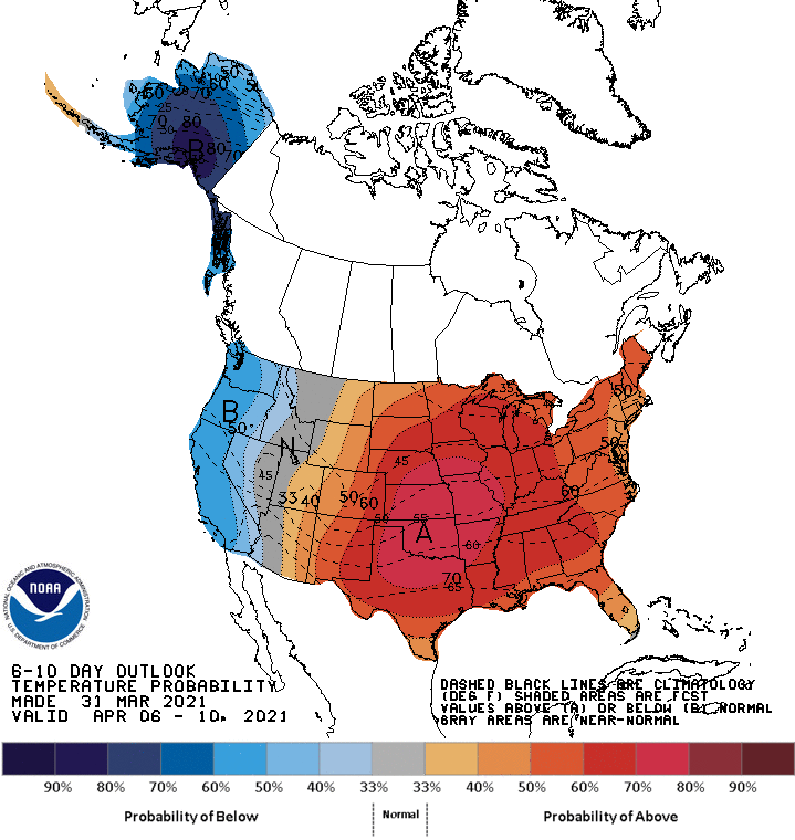
Not to say we might not suddenly see a below normal temperature outlook, but as
we go farther into spring, the odds increase that below normal temperatures
will stay above freezing.
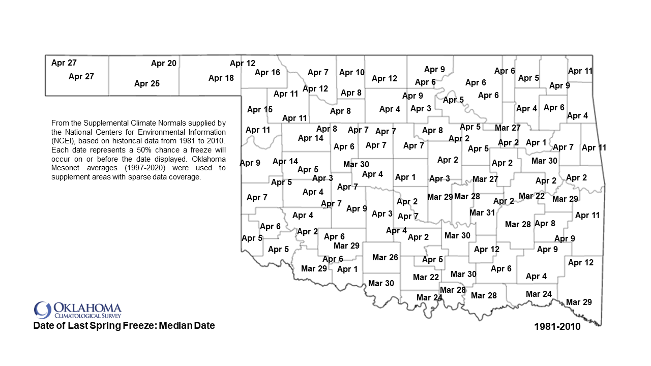
We're right on track for our average last freeze date across the southern half of
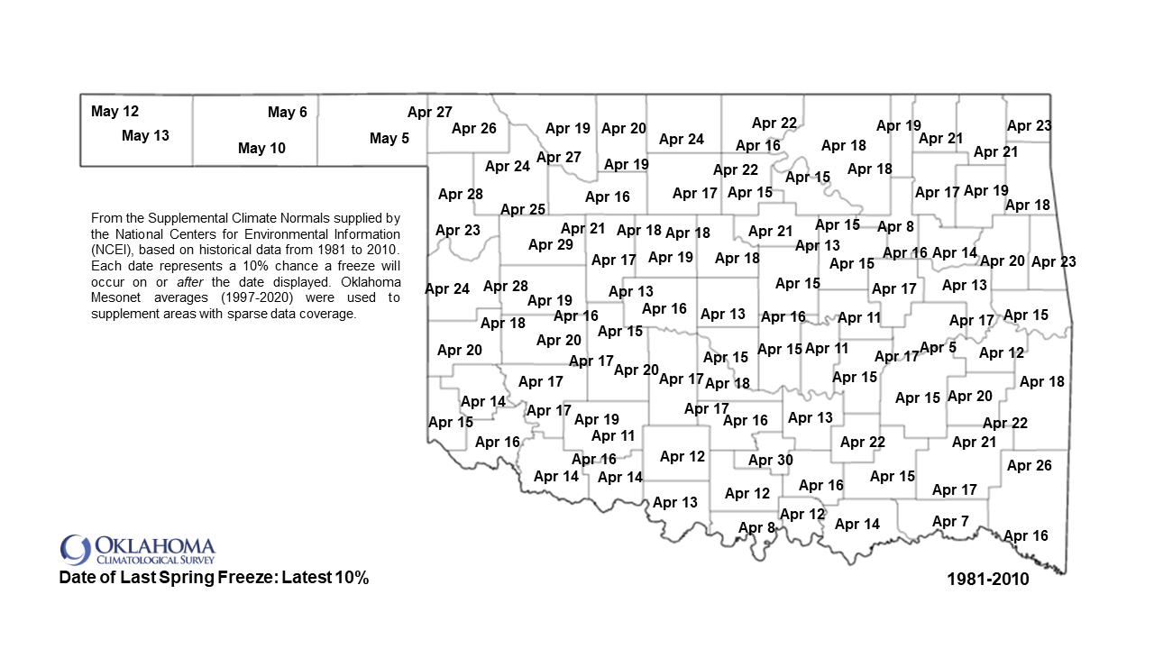
Oklahoma, so no shock if we don't see another. Now when we look at the latest
last freeze (on this map, the date at which there exists a 10% chance a freeze
will occur on or after the date displayed according to the 1981-2010 normals),
we can see that pushed out to the end of the month. We're at the tail extreme
edge of the probabilities for that, however, so it would still be a longshot.
For those with tender plants, a good stand of wheat, or just plain old cold
weather haters, we hope the first map holds true.
As we transition to a look back towards March, I'll just say it was a pleasure
to write this summary as compared to last month's Herculean effort. Biggest
news was the spring break craziness with a blizzard and tornado warnings, I
guess. And that's where I'll come in like a lamb and go out like a fool.
I mean a lion! Dang it.
-------------------------------------------------------------------------------
March Weather More Lamb Than Lion
April 1, 2021
The first month of spring greeted Oklahoma with warmer and more tranquil weather
than the historic cold and snowy February that preceded it. While March offered
up momentary glances of nearly every weather hazard in Oklahoma’s arsenal, the
month was most often quiet. By coincidence—although state lore will say it’s
the norm—the most active weather occurred during Oklahoma’s collectively shared
spring break. On March 16-17, local National Weather Service offices issued a
blizzard warning in the Panhandle, and severe thunderstorm and tornado watches
in the main body of the state. That storm system started with severe weather
across western Oklahoma the evening of the 16th, and transitioned to snow the
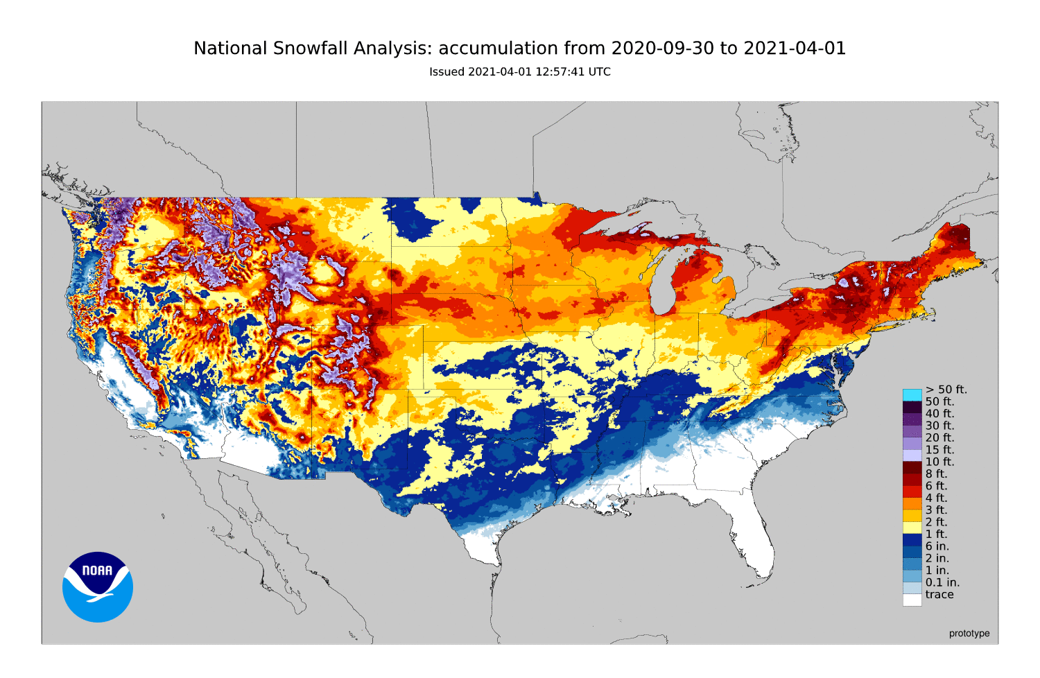
morning of the 17th. Snowfall of 3-4 inches was being driven by 40 mph winds to
create white-out conditions across far northwestern Oklahoma throughout the day
on the 17th while the severe weather was pushed east. The additional 3-4 inches
of snow across the northwest brought seasonal totals to more than 40 inches in
that region, with Arnett leading at 42.3 inches. Oklahoma City’s seasonal total
of 22.5 inches through March was just 2.7 inches behind its record tally of
25.2 inches from 1947-1948, and ranked sixth highest on record. Tulsa’s
seasonal total was 15.8 inches, its 17th highest on record and well behind
2010-2011’s 26.1 inches.
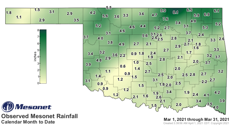
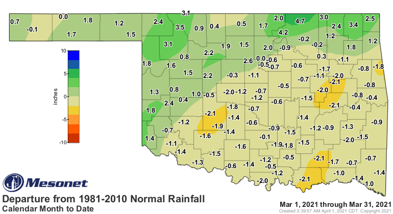
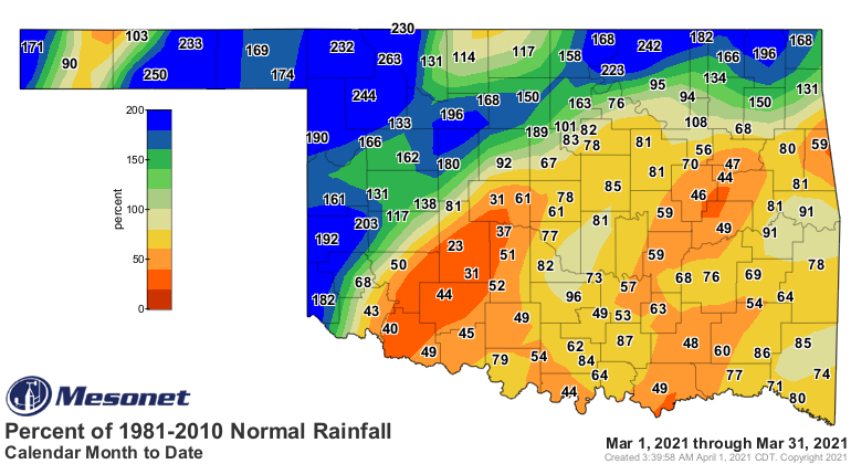
The statewide average precipitation total was 3.07 inches according to
preliminary data from the Oklahoma Mesonet, 0.03 inches above normal, to rank
as the 36th wettest March since records began in 1895. The northwestern half of
the state saw surpluses of 1-3 inches, while the southeast fell 1-2 inches
below normal. The moisture abundance was profound across parts of Oklahoma,
with the Panhandle, north central and west central sections each experiencing
one of their top 10 wettest Marches on record. The more robust totals came in
Osage County, where Foraker and Burbank tallied 8.06 inches and 7.59 inches,
respectively. Twenty-five of the 120 Oklahoma Mesonet sites recorded at least 4
inches of rain for the month. Thirty stations saw less than 2 inches, with Fort
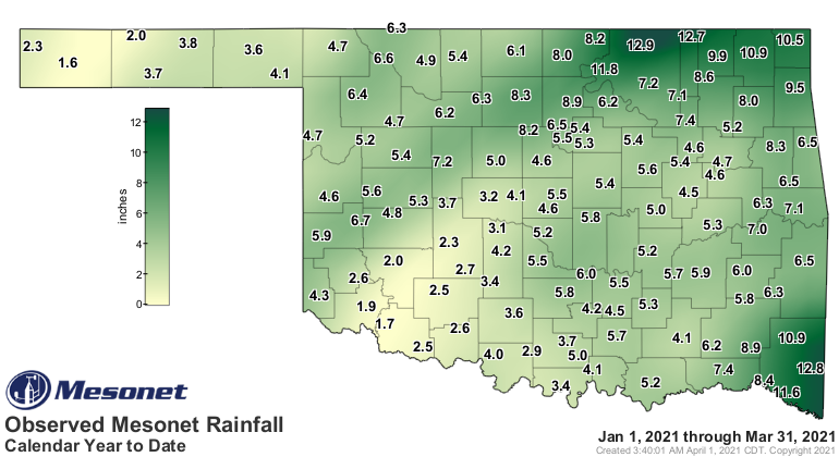
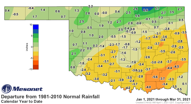
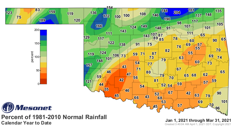
Cobb seeing the least at 0.64 inches. The first three months of the year ended
as the 51st wettest since 1895 with a statewide average of 6.2 inches, 0.23
inches below normal. The January-March moisture distribution was similar to
March’s pattern, with surpluses to the northwest and deficits to the southeast.
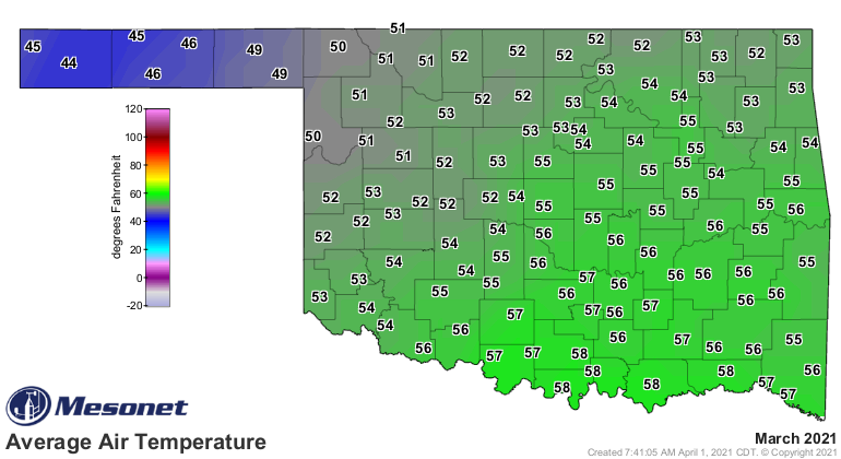
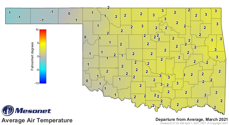
March was warm by any standard, but especially so following the historic cold
weather of the previous month. The statewide average temperature for the month
finished at 53.6 degrees, 3.2 degrees above normal, to rank as the 27th warmest
March on record. High temperatures rose into the 70s and 80s quite often, with
Beaver taking the top spot at 88 degrees on the 29th. Freezes were still common
through the month, especially across far northwestern Oklahoma. Kenton recorded
March’s lowest reading at 8 degrees on the month’s first day. The first three
months of 2021 ended at 41.9 degrees, 1.6 degrees below normal and ranked as
the 55th coolest January-March on record.
Drought continued to diminish in Oklahoma during March, dropping to an areal
coverage of 10.71 percent on the month’s final U. S. Drought Monitor map.
Drought was nearly eliminated across southwestern Oklahoma, although a newer
area of drought was attempting to intensify and spread across south central
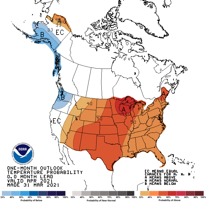
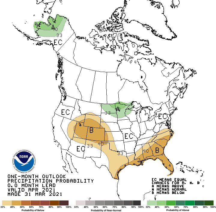
Oklahoma. The April temperature and precipitation outlooks from the Climate
Prediction Center (CPC) indicated increased odds of above normal temperatures
across the entire state, and below normal precipitation across the western
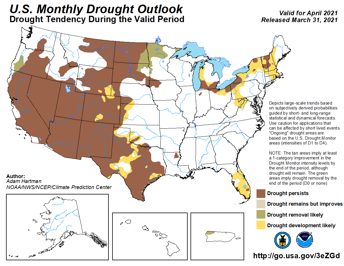
half of Oklahoma. Given those outlooks, CPC’s April drought outlook considered
drought development likely in southwestern and west central Oklahoma, with no
changes considered likely over the rest of the state.
Gary McManus
State Climatologist
Oklahoma Mesonet
Oklahoma Climatological Survey
(405) 325-2253
gmcmanus@mesonet.org
April 1 in Mesonet History
| Record | Value | Station | Year |
|---|---|---|---|
| Maximum Temperature | 98°F | ALTU | 2012 |
| Minimum Temperature | 19°F | EVAX | 2023 |
| Maximum Rainfall | 2.57″ | TIPT | 2006 |
Mesonet records begin in 1994.
Search by Date
If you're a bit off, don't worry, because just like horseshoes, “almost” counts on the Ticker website!