Ticker for May 11, 2020
MESONET TICKER ... MESONET TICKER ... MESONET TICKER ... MESONET TICKER ...
May 11, 2020 May 11, 2020 May 11, 2020 May 11, 2020
The eyes have it
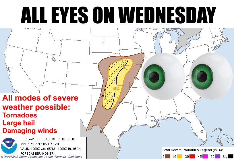
Uh oh, Wednesday looks like one of THOSE days in Oklahoma. You know, the kind
that we tend to talk about for a few days afterwards. No, not because one of our
teams lost a football game. That's one of THEM days where we talk about it for
years afterwards. Basically, we're gonna have chances of rain everyday from now
on. No, not for this week, FROM NOW ON!
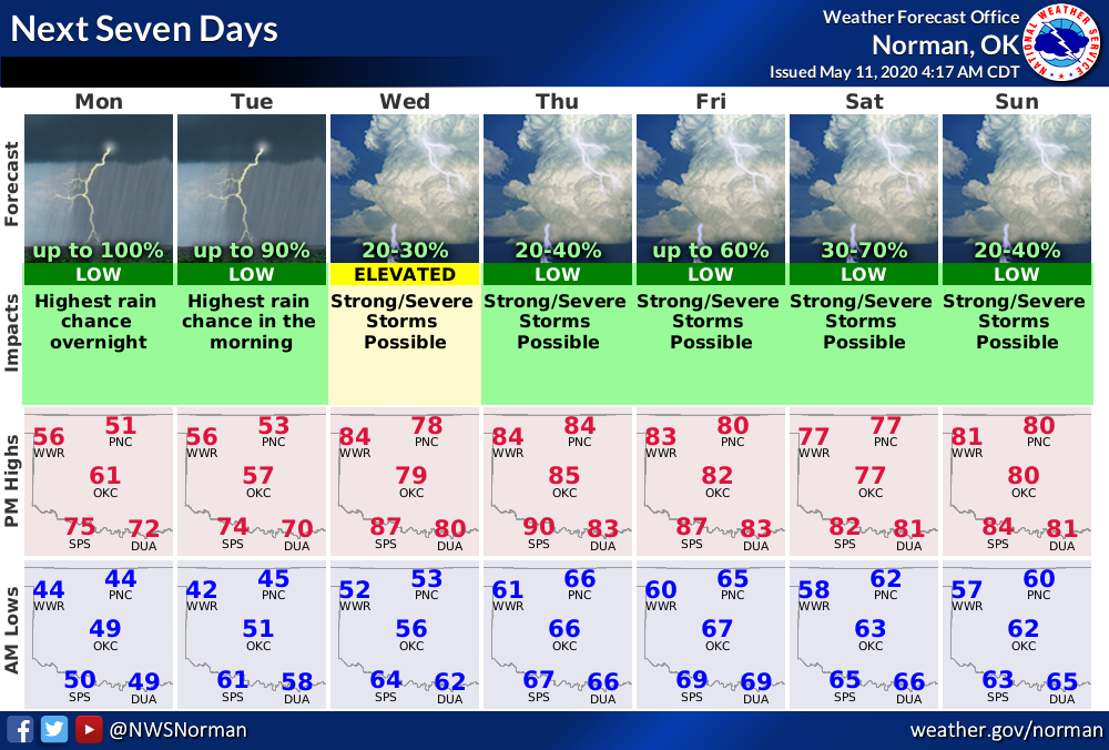
Okay, I'm a bit prone to exaggeration, but we will see those rain chances
increased throughout the week (and maybe beyond). And we could see a lot of rain
with this week of active weather, like 4-5 inches across parts of...GULP...
northeastern Oklahoma.
I'll just wait a bit while those from the northeast to calm down. Breathe! Feel
free to cuss it back to the west. You gave it a good shot there, but all you
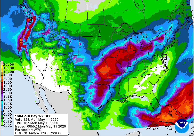
did was burn more hair off my head. You can see from that 7-day planner (which
is primarily for the Norman NWS forecast area, but it can generally represent
the main body of the state) that we should expect rain off and on over the next
couple of days, along with some unseasonably cool weather. Then we have a
rapid warm up on Wednesday to coincide with the arrival of another storm
system. We'll see a dryline set up across the Panhandle with the possiblity
of thunderstorms firing up along that dryline. According to SPC, it might not
be a dense line marching across the state, at least when they are at their
most severe, but more scattered coverage:
As a result, the expectation is for the surface pattern on Wednesday
afternoon to feature a low over southeast CO with a dryline arcing
southeastward into northwest OK and then back southwestward through
the TX Permian Basin. Conditions east of the dryline are expected to
be characterized by temperatures in the 80s, dewpoints in mid 60s,
very steep mid-level lapse rates, and vertically veering low-level
wind profiles. Convective initiation is anticipated along the
dryline with these storms quickly developing into supercells capable
of all severe hazards, including very large hail and tornadoes.
Given the strong EML (and resultant capping) and lack of stronger
forcing for ascent, widely scattered coverage is currently
anticipated, which precludes higher than 15% severe probabilities
with this forecast."
So it sounds like that capping inversion -- layer of warm air above the
surface -- might keep that coverage down of the most severe storms. Can't say
what that will mean as they head to the east IF they fire up. And remember,
we've seen these types of scenarios a few days down the road and they've ended
up with no storms forming due to that capping inversion, but also a whole
bunch of storms firing because the inversion wasn't as strong as forecast. In
other words, prepare for the worst, hope for the best!
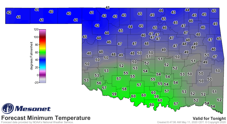
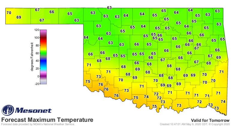
We still have to get through these next couple of March-like days. Highs today
will struggle to get out of the 50s for northern Oklahoma. Heck, some places
will struggle to escape the 40s! It'll be downright chilly tomorrow morning.
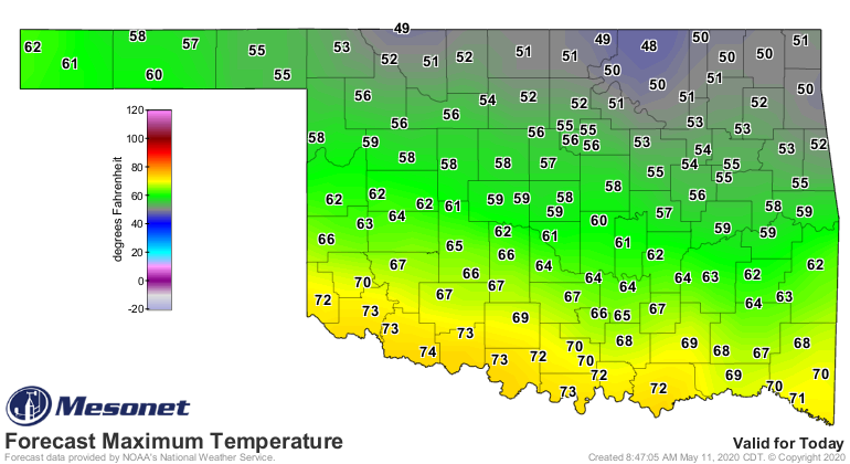
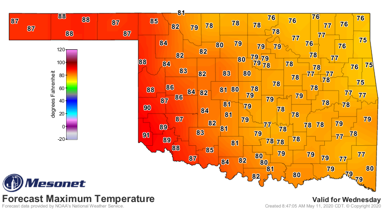
That return heat and moisture is the key for Wednesday. It's tough to get big
storms without it. Not impossible, just tougher. But, heat we will have, at
least across far western Oklahoma in the storm initiation zone.
So lots of water this week, potentially, and some days to watch out for. Keep
those eyes open, and hope for strong inversions!
Gary McManus
State Climatologist
Oklahoma Mesonet
Oklahoma Climatological Survey
(405) 325-2253
gmcmanus@mesonet.org
May 11 in Mesonet History
| Record | Value | Station | Year |
|---|---|---|---|
| Maximum Temperature | 106°F | ALTU | 2000 |
| Minimum Temperature | 30°F | BOIS | 2008 |
| Maximum Rainfall | 5.87″ | HUGO | 1999 |
Mesonet records begin in 1994.
Search by Date
If you're a bit off, don't worry, because just like horseshoes, “almost” counts on the Ticker website!