Ticker for April 23, 2020
MESONET TICKER ... MESONET TICKER ... MESONET TICKER ... MESONET TICKER ...
April 23, 2020 April 23, 2020 April 23, 2020 April 23, 2020
Knots on your noggin
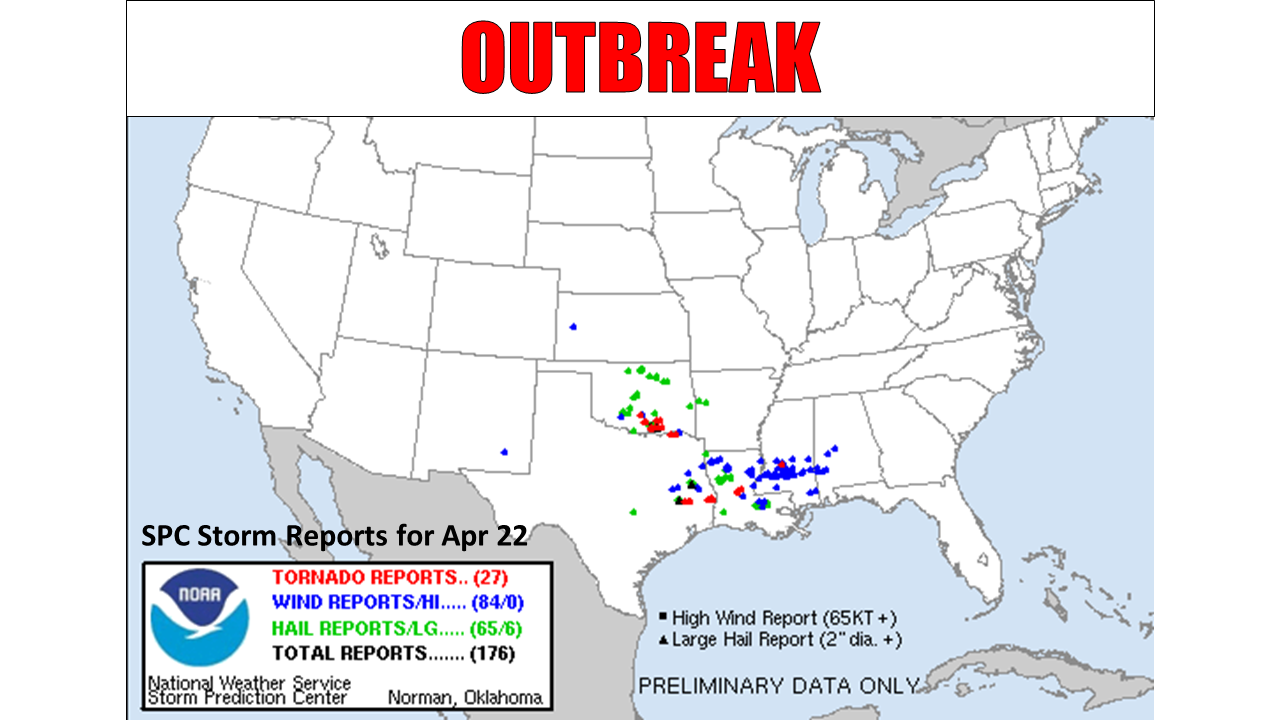
And just like that, spring's severe weather season erupts on a day that just a
couple of days ago looked a little more benign. As many as 10 tornadoes may have
touched down across southern Oklahoma yesterday according to preliminary reports.
One of the larger tornadoes struck Madill, killing two and damaging at least a
dozen homes. The exact number and strength of the tornadoes won't be known until
NOAA personnel survey the damage sites. There were five tornadoes (3 in January,
2 in March) during the first three months of the year, so yesterday's total will
bring Oklahoma close to the 1950-2019 January-April average (16) for the year
thus far. The two fatalities were the first in the state due to a tornado since
May 25 of last year near El Reno.
The storm system that spawned the tornadoes up and down south I35 and points east
actually began impacting the state on the 21st with damaging winds and large
hail. Baseball hail fell across western Oklahoma, damaging homes and automobiles.
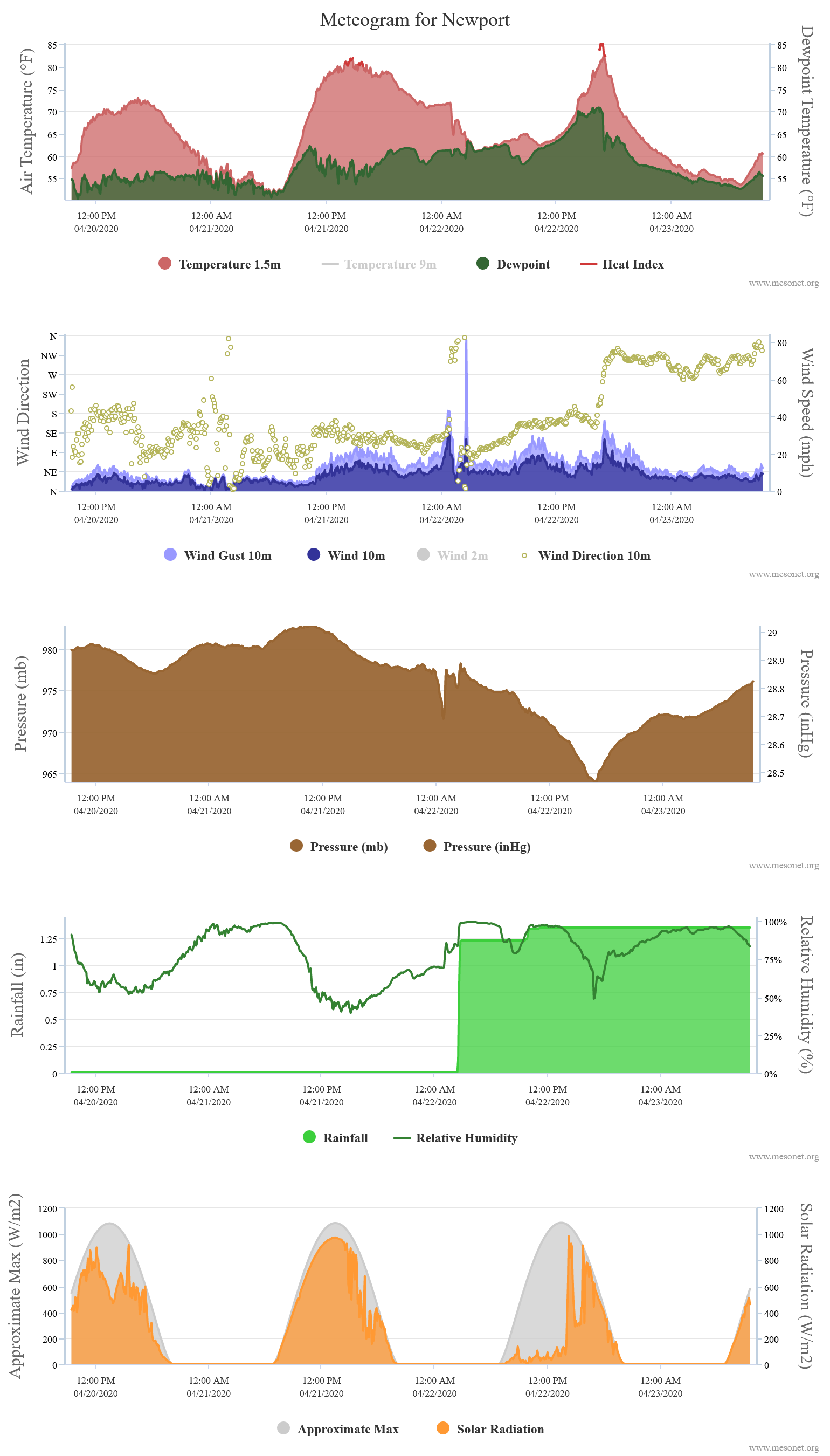
An 81 mph wind gust was recorded by the Newport Oklahoma Mesonet site at 2:35am
early on the 22nd as well, associated with straight-line severe thunderstorm
winds.
There were at least 78 reports of hail an inch or greater over the two days,
and a dozen wind reports of 60mph or greater. That's obviously an undersampling
of both hazards, but enough to show the scope of the severe weather outbreak.
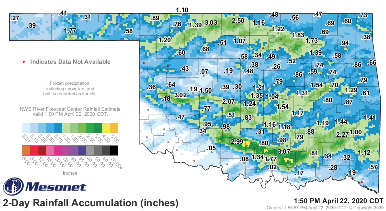
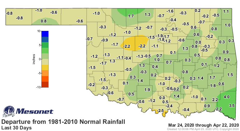
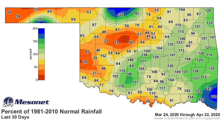
The storm system did bring both wanted and unwanted rains to the state. Western
Oklahoma sorely needed the moisture, and while not all received it, those that
did welcomed it. Folks across eastern Oklahoma threw up the white flag asking
for a bit of a longer dry period. The training thunderstorms dropped 2-3 inches
across a narrow band in southern Oklahoma, and a broader band of 1-3 inches fell
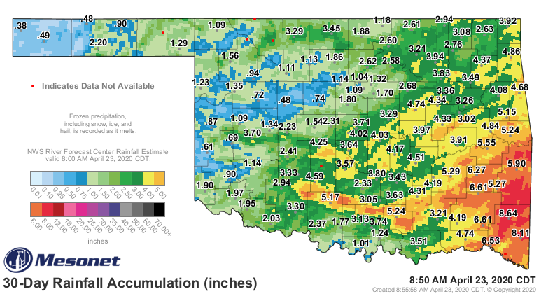
across their counterparts in northern Oklahoma. The totals brought parts of
western Oklahoma a bit closer to normal for the last 30 days, but significant
deficits remained.
This week's U.S. Drought Monitor doesn't reflect any of that rainfall, with the
cutoff for precipitation to be considered ending Tuesday morning, but we will
re-evaluate for next week's map. This week's map shows an increase in
"Abnormally Dry" conditions, a precursor to drought, centered in Beaver and
Roger Mills counties.

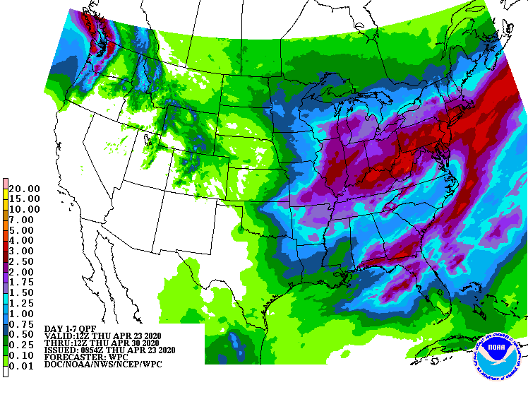
The chance for rain goes up again tonight and tomorrow, but as per usual (and
climatology), amounts look higher across eastern Oklahoma.
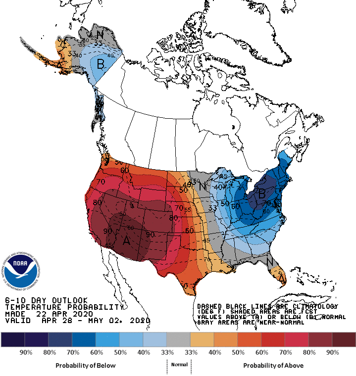
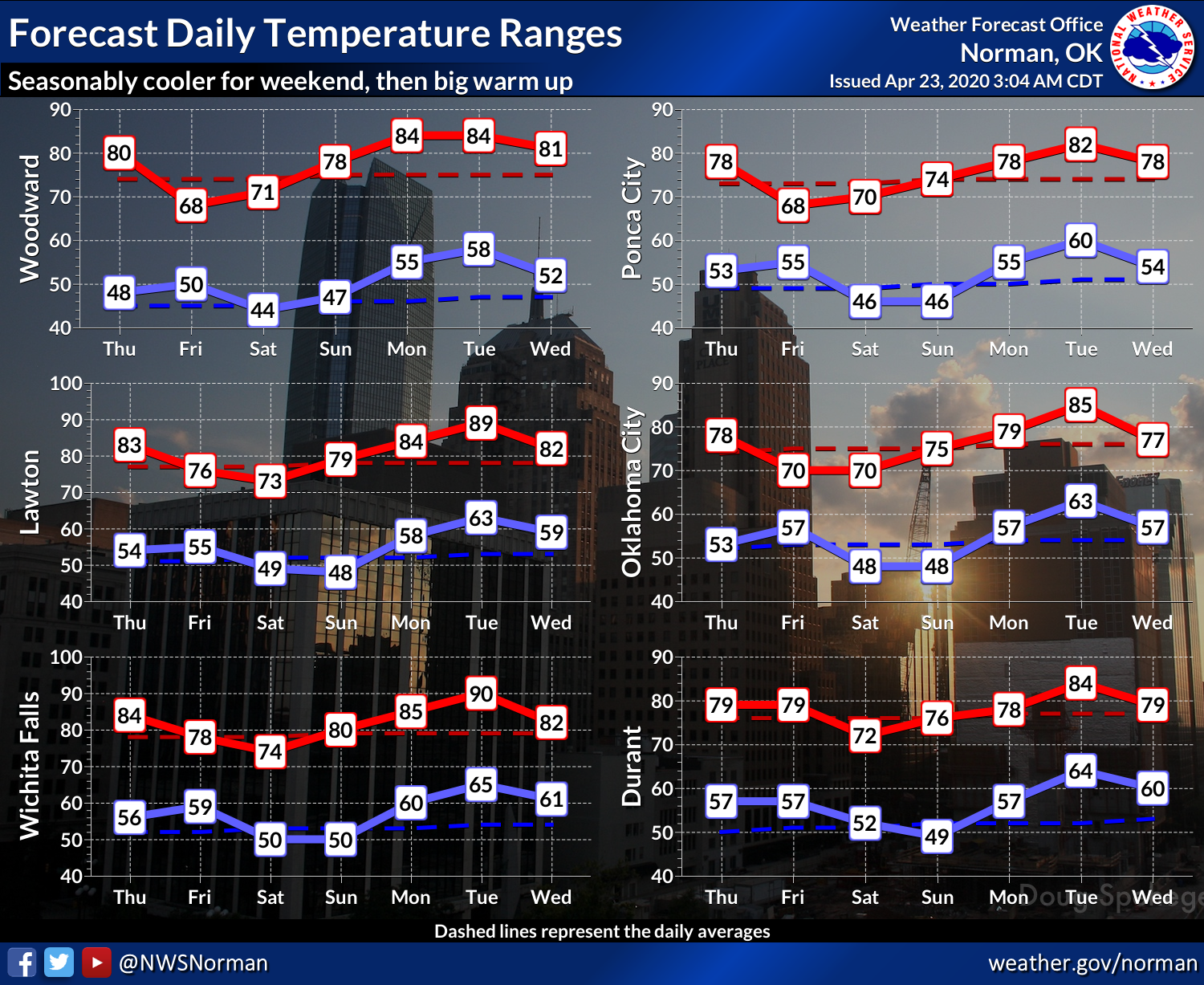
And next week, the heat ramps up to finish out the month.
The good news is there are no signs of a damaging frost/freeze event on the
horizon, which is good news for rural and urban farmers alike. This graph from
our friends at the Norman NWS office only accounts for their forecast area,
but it is representative of the entire state to a degree (or 32 degrees, pardon
the pun).
Mother Nature jumped up and popped us on the nose the last couple of days to
remind us she's here. With a chance of severe weather possible tomorrow, even
though as of now it looks a bit mundane, this is a renewed lesson to stay
weather aware because the fine lines of those forecasts can change in a hurry.
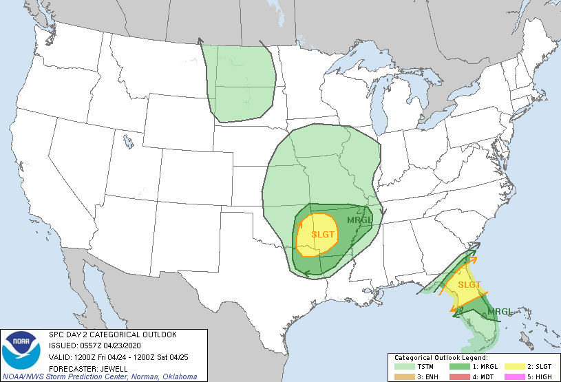
While it looks more like another hail event, keep in mind that large hail can
put knots on your noggin faster'n you can rub 'em, and severe storms in Oklahoma
can drop tornadoes whether those are forecast or not.
Gary McManus
State Climatologist
Oklahoma Mesonet
Oklahoma Climatological Survey
(405) 325-2253
gmcmanus@mesonet.org
April 23 in Mesonet History
| Record | Value | Station | Year |
|---|---|---|---|
| Maximum Temperature | 97°F | HOOK | 2006 |
| Minimum Temperature | 17°F | BOIS | 2013 |
| Maximum Rainfall | 3.68″ | HOBA | 2019 |
Mesonet records begin in 1994.
Search by Date
If you're a bit off, don't worry, because just like horseshoes, “almost” counts on the Ticker website!