Ticker for January 9, 2020
MESONET TICKER ... MESONET TICKER ... MESONET TICKER ... MESONET TICKER ...
January 9, 2020 January 9, 2020 January 9, 2020 January 9, 2020
SNOWFLOODNADOMAGEDDON!
Uh huh, now we're cooking with electric burners! The big storm system has finally
come over land and has been better sampled by the various meteorological
observation networks and the forecast models are starting to become a bit more
rational. It still has to make it over the Rockies, get disrupted a bit, and come
back together, and THEN we'll be cooking with gas. Until then, it does appear this
storm will be a little stronger than it first looked, will slow down a bit, and
have the ability to really pump moisture up over the region on those strong
southerly winds coming off the Gulf of Mexico. Then Mother Nature
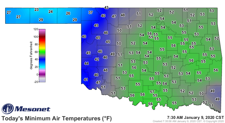
will be cooking with gas. The record morning lows from this morning are a sign of
that moisture, in some cases those record morning lows were shattered.

As are these unusually high dewpoints. What a change from yesterday and its
dry air and fire danger.
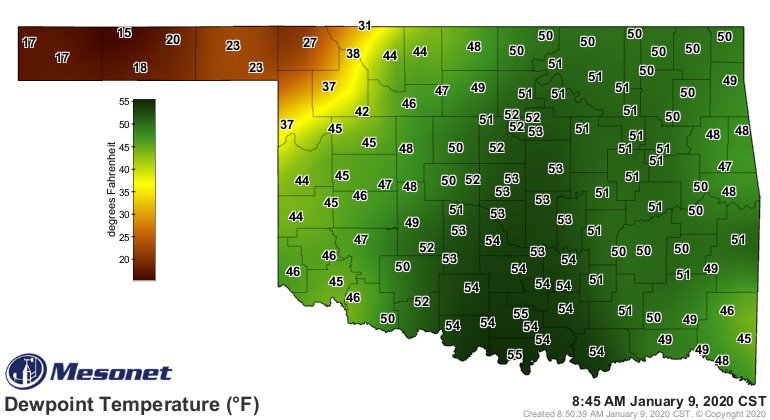
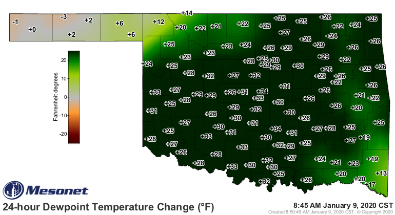
Did ya know that the dewpoint is sorta the lower limit to what the actual air
temperature can drop to, since if the temperature drops to that dewpoint
temperature, water starts to condense, thus releasing the latent energy required
to originally evaporate that water as latent heat, which becomes sensible heat
transferred to the air from the liquid, thus (part 2) keeping that temperature
from dropping from below the dewpoint (GASP!). Made it in one breath, and with
only minor-to-slightly-major physics mistakes.
As another side note, did ya know that energy cannot be created nor destroyed?
That's the first law of thermodynamics. The moose out front should have told
ya. By the way, the not so well known fifth law of thermodynamics states that
a twinkie cannot be created nor destroyed unless eaten. Those things last
forever.
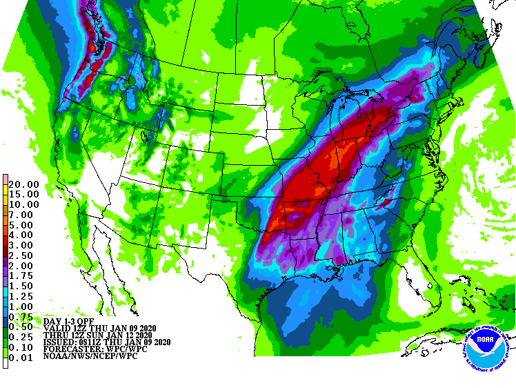
Anyway, back to the weather. As those instruments have sampled the storm, the
forecast has generated a record amount of precipitable water in the air,
available to be condensed into precipitation. That spells flooding trouble over
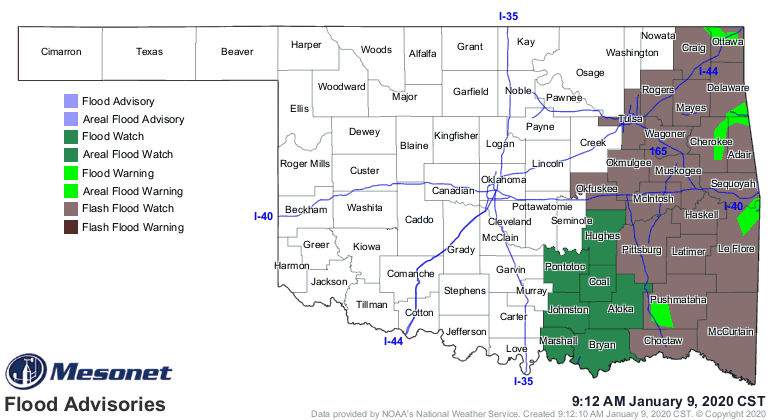
the next couple of days, especially in SE OK. The NWS has already issued
flash flood and areal flood watches for eastern OK, in some cases where flood
warnings are ongoing. This is a serious threat and shouldn't be trifled with.
Turn around don't drown.
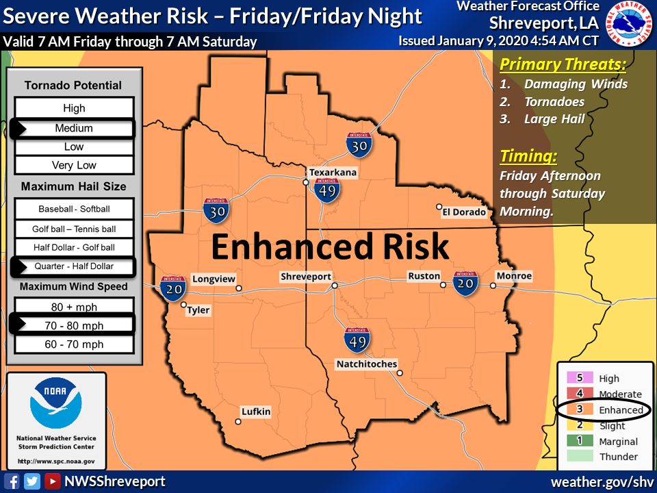
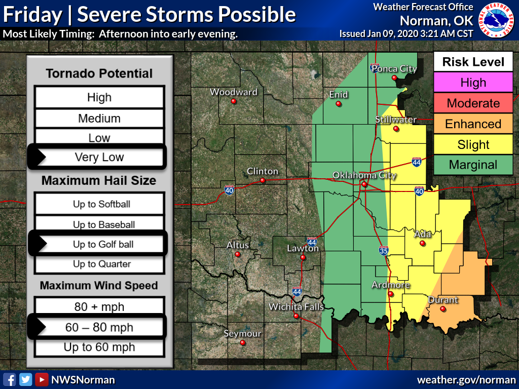
Now as the accompanying cold front enters the state and encounters the moisture,
watch out for thunderstorms developing and eventually forming a line as they
march from possibly central into eastern Oklahoma. All modes of severe weather
are possible, especially hail and strong winds. Yes, tornadoes are possible,
especially before the storms form into that line. Southeast Oklahoma is under
particular threat from severe weather. Down farther into Texas...well, GULP.

Then the cold air behind the front plunges in, we get possible brief flashes
of ice before the cold air deepens in the upper levels before a transition to
mostly snow from Friday night in the NW into Saturday for the rest of us. Now
most meteorologists are a bit tentative on giving a pinpoint snow forecast lest
it hurt their credibility. That being said, here's my pinpoint snow forecast.
AHA! Nice try. While I have no credibility, I'd like it to remain that way. Wait,
maybe that didn't come out right. With still a few-to-many changes in the
forecast yet to come as the model output comes together a bit better, let's go
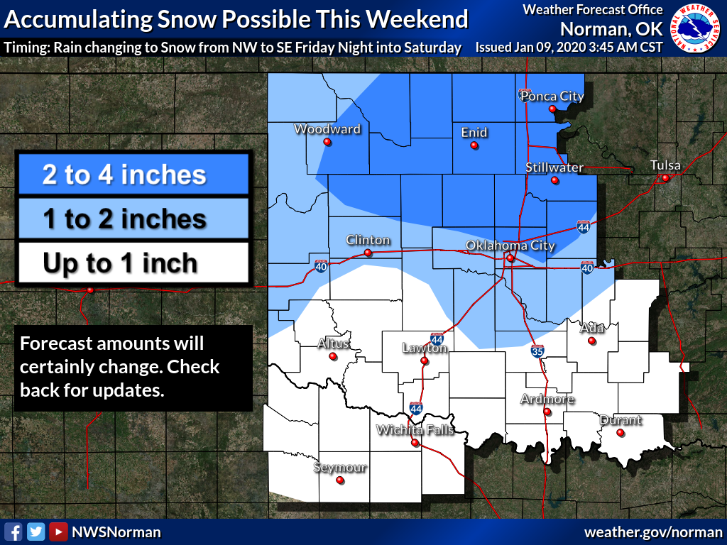
with the general outlook of heaviest snow in north central OK (up to 4 inches,
with a few places possibly seeing more), less to the east and west, and
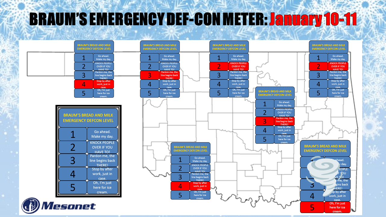
tapering off as you go south. But here's the deal, as you can see from our
BRAUM'S EMERGENCY DEF-CON METER, we did put a DEF-CON LEVEL 2 in the northeast.
I was also tempted to bring it a bit farther south into central Oklahoma, since
some of the model output brings a heavier line of snow down into northern Texas,
even, but we'll wait and see on that. We did put a 4 down in the SW just in case.
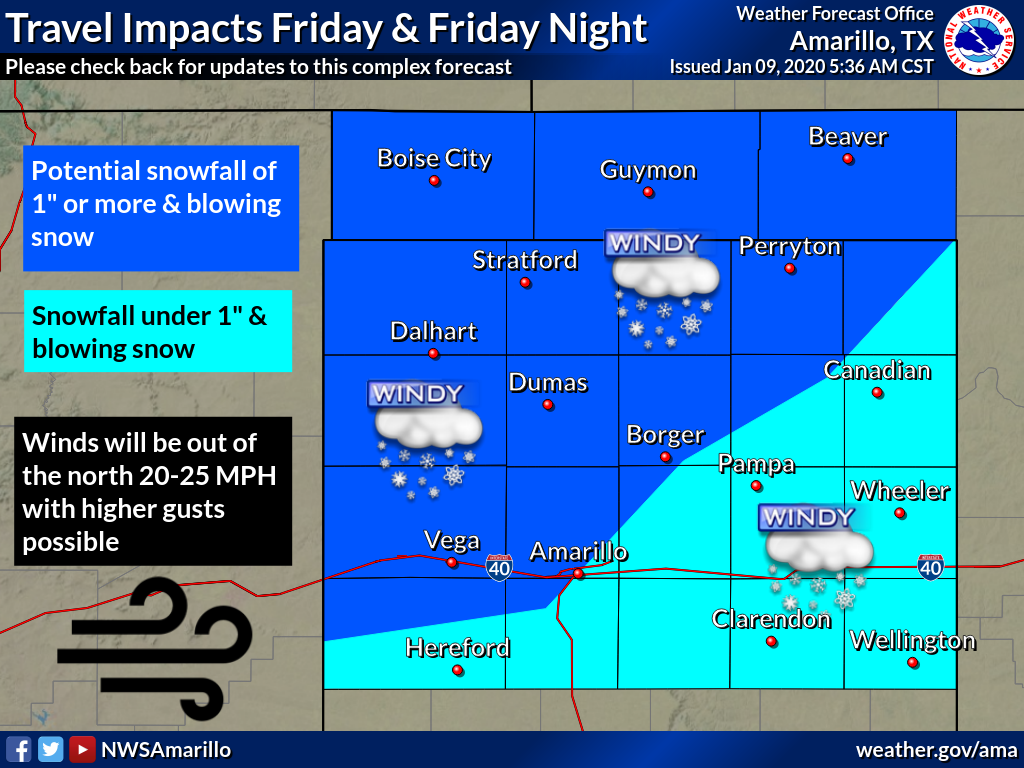
Here's what our friends at the NWS offices have thrown out so far. They have
cautioned, very wisely, that this could change quite a bit over the next 24-36
hours.
Okay, we've blathered on enough. Here's the deal...this is a weekend where you
need to stay weather aware. This forecast can and probably will change, possibly
significantly, bringing YOUR area a higher chance for dangerous weather.
At the very least, we should ALL be prepared to freeze our hind ends off this
weekend. That's the curse of warm weather here in the Southern Plains during
winter...eventually, reality returns.

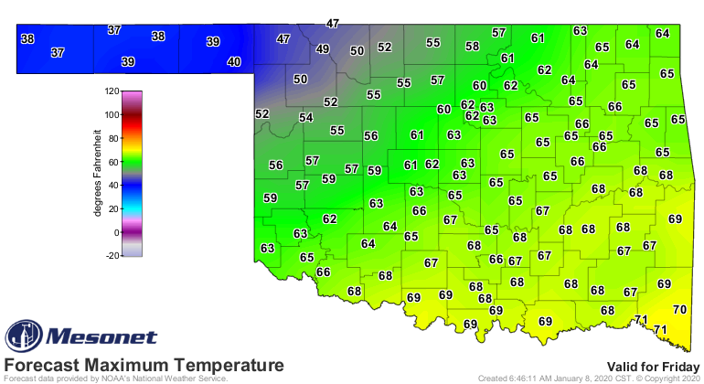

And enjoy the ensuing warm up, because late next week, the arctic hits the fan.
Gary McManus
State Climatologist
Oklahoma Mesonet
Oklahoma Climatological Survey
(405) 325-2253
gmcmanus@mesonet.org
January 9 in Mesonet History
| Record | Value | Station | Year |
|---|---|---|---|
| Maximum Temperature | 81°F | ALTU | 2009 |
| Minimum Temperature | -4°F | JAYX | 2010 |
| Maximum Rainfall | 1.09″ | BROK | 2013 |
Mesonet records begin in 1994.
Search by Date
If you're a bit off, don't worry, because just like horseshoes, “almost” counts on the Ticker website!