Ticker for December 4, 2019
MESONET TICKER ... MESONET TICKER ... MESONET TICKER ... MESONET TICKER ...
December 4, 2019   December 4, 2019   December 4, 2019   December 4, 2019


Miam-uh Beach


As I was speaking to a Miami News-Record reporter earlier this week about how
much rainfall they've received this year (also, I DRIVE A DODGE STRATUS...BIG
TIME STUFF!), I was forced to dig into the record books a couple of weeks early
for our end-of-year wrap-up.

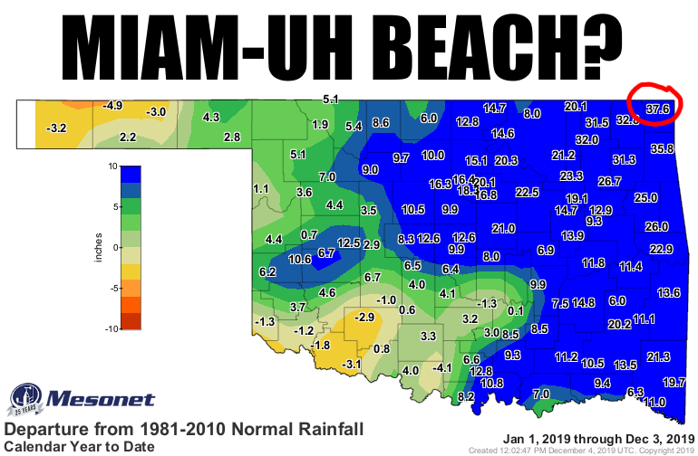
37.6 inches above normal? For the year? Are you kidding me? I mean...am I kidding
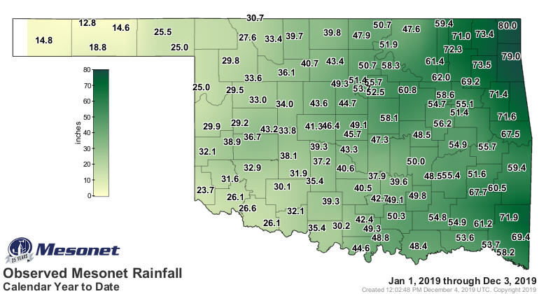
you? NO! Miami has received 80 inches of rain for the year thus
far. 80 inches? For the year? Are you ki-, well, we already went through that. No,
I ain't kidding. And for you neo-Okies, that is pronounced DOO-rant. Wait, wrong
weirdly pronounced location. It's pronounced my-AM-uh. So what do you have when
you've hit 80 inches for the year (with 3 weeks to go)? Well, you hit the all-time
record for that location, most likely. Here are the top-5 ANNUAL rainfall totals
for Miami, OKLAHOMA.

2019: 80.00" (Mesonet)
1973: 66.85" (NWS COOP)
2015: 64.00" (Mesonet)
1985: 63.86" (NWS COOP)
1927: 57.21" (NWS COOP)

When you top your previous record by more than 13", you've done a bit of hard work
for the year. And it's pretty darned close to the wettest year for ANY location
in state history. We don't have to go back too far to see wetter, however.
Remember 2015's monster El Nino, that gave us the wettest year on record based
on statewide average? Well, that year Daisy in Atoka County hit 89.69",
besting Tuskahoma's 88.27" from 1990. It's tough to beat a SE OK station for
rainfall records, though. Cheer up, NE OK. You still have the 24-hour snowfall
record of 27" at Spavinaw (Feb. 10, 2011). Let me also note that a CoCoRaHS
volunteer observer, uhhh, observed 90.47" in 2015 as well. We stuck with the
recognized record fro Daisy for the sake of this Ticker, however.

And it's not like Jay (pronounced "Jay"...you're welcome) is that far behind
with their 79 inches. Most of the stations across far NE OK have set their
high water mark (pun intended) for annual rainfall this year. Now on the other
end of the spectrum is Eva, OK, in Texas County, which has had 12.8" thus far
in 2019. Even though that's only 5" below normal for that area, it's still
only 72% of normal, and for an annual total, that means drought. The last 60-
120 days haven't helped much either. More on that tomorrow.

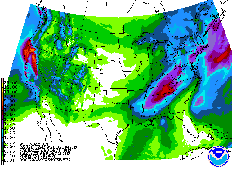
Don't expect the totals to go up much in the next week. Some light rain here
and there a time or two, then maybe something more exciting lurking later
next week?


Gary McManus
State Climatologist
Oklahoma Mesonet
Oklahoma Climatological Survey
(405) 325-2253
gmcmanus@mesonet.org
December 4 in Mesonet History
| Record | Value | Station | Year |
|---|---|---|---|
| Maximum Temperature | 83°F | BURN | 2017 |
| Minimum Temperature | -2°F | NOWA | 2006 |
| Maximum Rainfall | 2.44 inches | MIAM | 1999 |
Mesonet records begin in 1994.
Search by Date
If you're a bit off, don't worry, because just like horseshoes, “almost” counts on the Ticker website!