Ticker for December 2, 2019
MESONET TICKER ... MESONET TICKER ... MESONET TICKER ... MESONET TICKER ...
December 2, 2019 December 2, 2019 December 2, 2019 December 2, 2019
The most boring time of the year
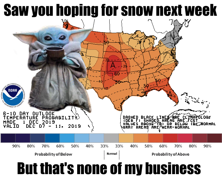
Well November's weather was a dud mostly, and that's a good thing, right? We
DIDN'T get the frozen weather Thanksgiving morning, mostly (sorry Panhandle),
and we DIDN'T see any tornadoes last Friday (a couple of severe storms at best,
and that's a good thing, right?). About the only hazard that came through was
the wildfires last Tuesday. And that wasn't a good thing. Now we're off into
December and things are looking boring for awhile. A few cold fronts in the next
week or two, maybe some rain on Thursday? Looks warm next week, at least by
December's standards.
All of this can change in a hurry! One thing not likely to change anytime soon
is the droughty conditions across western Oklahoma.
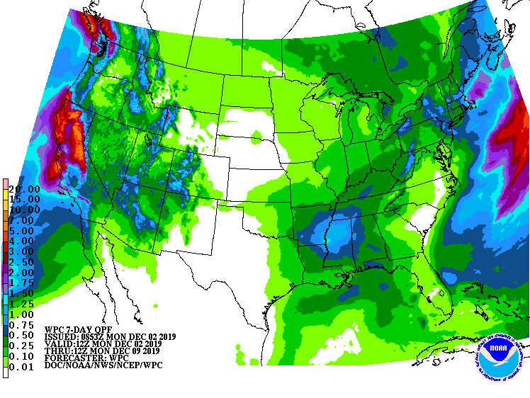
So enjoy the boring for now. It's Oklahoma. It'll get exciting before you know
it.
Speaking of boring, here's the November monthly summary. Read before bedtime.
It's better than Ambien.
----------------------------------------------------------------------------------
November Feels Winter Chill
Dec. 2, 2019
November’s weather was somewhat tame by Oklahoma’s standards, with cold weather
dominating the headlines. Several intrusions of arctic air blasted the country
during November, and Oklahoma caught the edges of the frigid weather each time.
Along with that cold came a mostly dry month across a droughty western Oklahoma.
Heavy rains fell across the eastern half. There was a bit of snow across far
northern Oklahoma – totals of 2-4 inches were observed in the Panhandle. A
couple of thunderstorms in the east managed to exceed severe limits during the
month’s final two days; wind and hail being the main threats. An outbreak of
wildfires occurred on Nov. 26 when a strong storm system moved through the
state, kicking winds up over 60mph. Interacting with low humidity and
temperatures in the 70s and 80s, those winds allowed fires to spread rapidly,
prompting evacuations and widescale emergency response from local, state and
federal fire crews. In addition, more than 15,000 residences and businesses
were without power due to the high winds.
According to preliminary data from the Oklahoma Mesonet, the statewide average
temperature was 46.4 degrees, the 38th coolest November since records began in
1895. The highest recorded temperature of 81 degrees occurred twice – at Buffalo
on the ninth and Waurika on the 19th. The Mesonet site at Eva fell to minus 4
degrees on the 12th for the lowest temperature of the month. The wind chill
dropped below zero 39 times at the Mesonet’s 120 sites, with Eva’s minus 17
degrees on the 12th setting the low mark. The climatological fall
(September-November) ended as the 53rd warmest on record, 0.4 degrees above
normal. The first 11 months of the year were 0.3 degrees below normal, the 57th
coolest January-November on record.
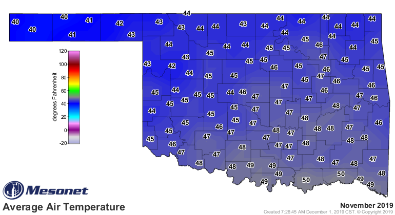

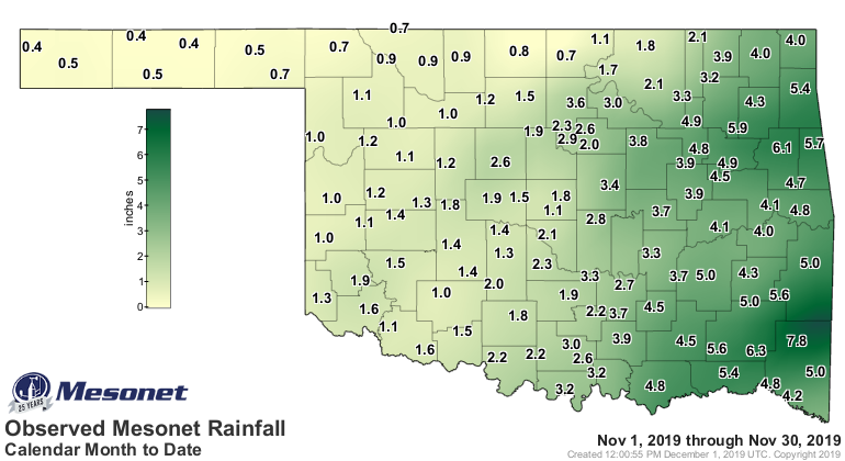
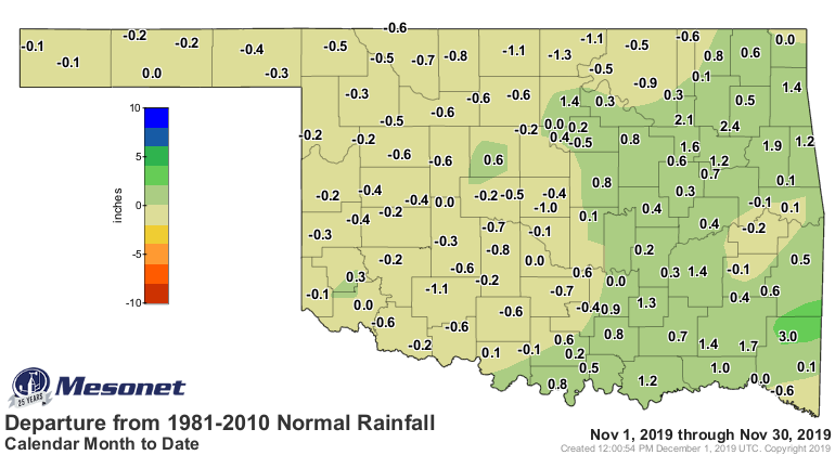
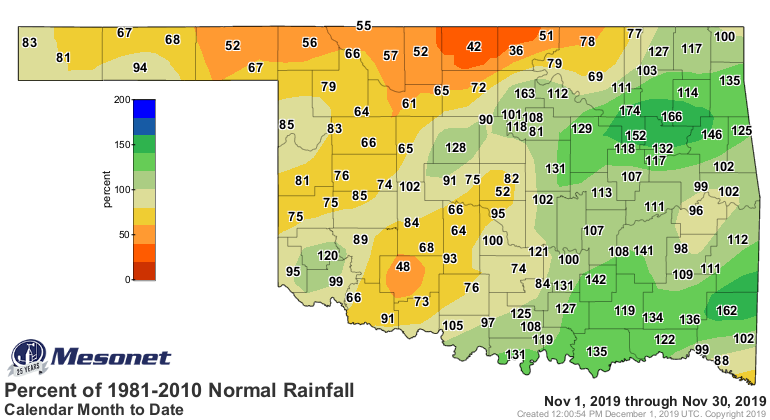
As has been the case in recent months, the heaviest precipitation fell across
eastern portions of the state while the western half was left mostly dry.
Totals ranged from 4-6 inches across the east. The western half received 1-2
inches in general, but north central and northwestern sections saw less than an
inch. The statewide average was 2.55 inches, 0.04 inches above normal to rank
as the 45th wettest November on record. Mt. Herman led all Mesonet sites with
7.79 inches. Eva received 0.36 inches for the lowest total.
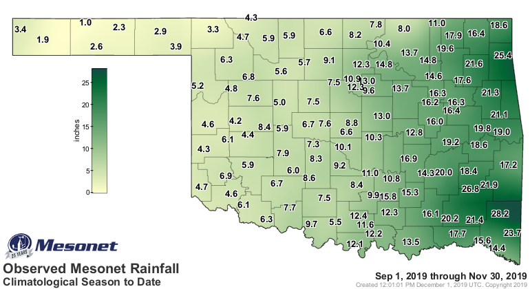
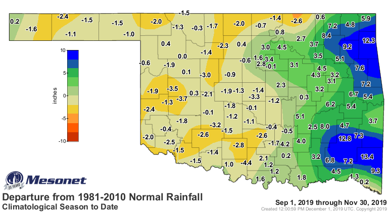
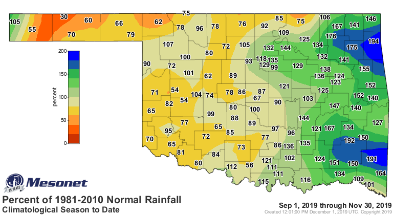
The fall season matched November’s pattern; it was generally dry across western
Oklahoma and exceedingly wet across the east. The September-November statewide
average was 10.04 inches, 0.46 inches above normal to rank the 41st wettest
fall on record.
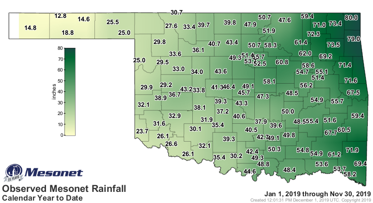
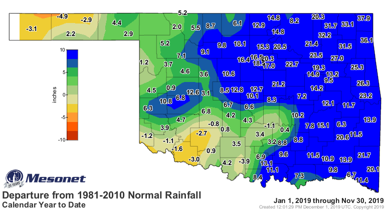
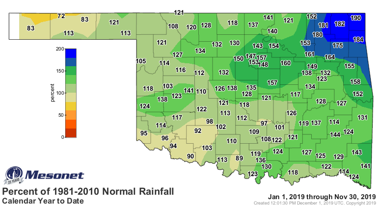
The year continues on pace to be one of the top 10 wettest in state history.
The January-November statewide average of 43.84 inches ranked as the seventh
wettest on record with a surplus of 9.4 inches, and is already the eighth
wettest calendar year on record. Northeastern Oklahoma shattered its annual
record total with a month to spare. That area’s average January-November total
was 61.65 inches, 21.33 inches above normal. The previous record annual total
was 57.82 inches from 1973.
Given the ongoing dry weather across western Oklahoma, drought managed to
increase and intensify during November. Drought coverage increased from 8% at
the end of October to 13% at the end of November according to the U.S. Drought
Monitor. The area in severe drought increased from 1% to 4%, predominantly in
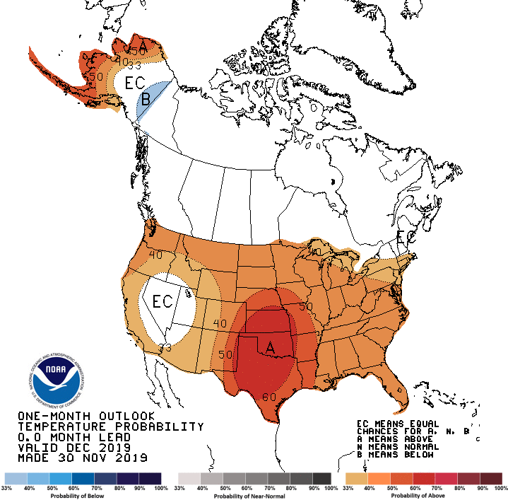
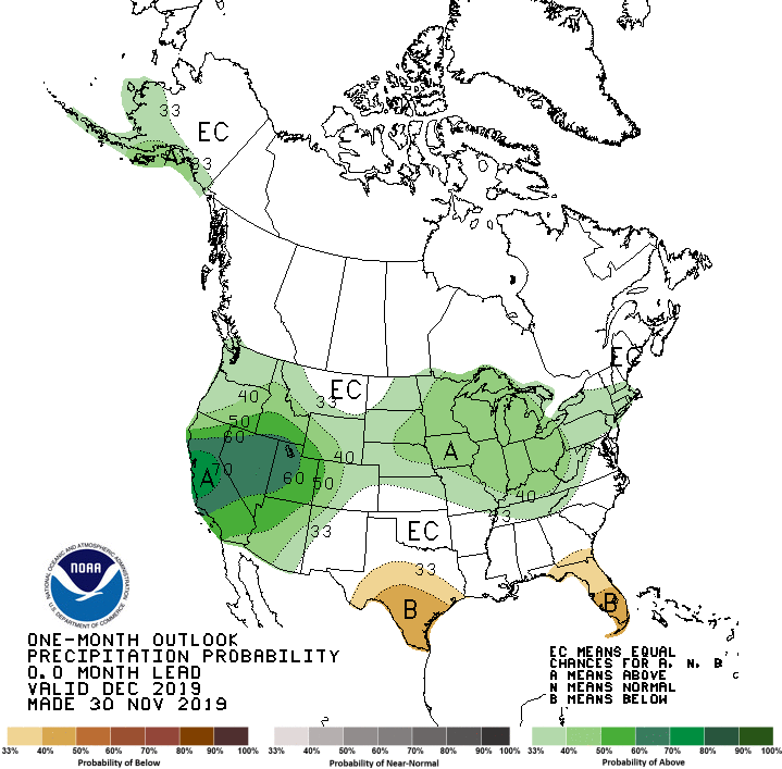
the western Panhandle. The main feature of the December temperature and
precipitation outlooks from the Climate Prediction Center (CPC) was greatly
increased odds of above normal temperatures across the Southern Plains –
including Oklahoma. The precipitation outlook called for equal chances of
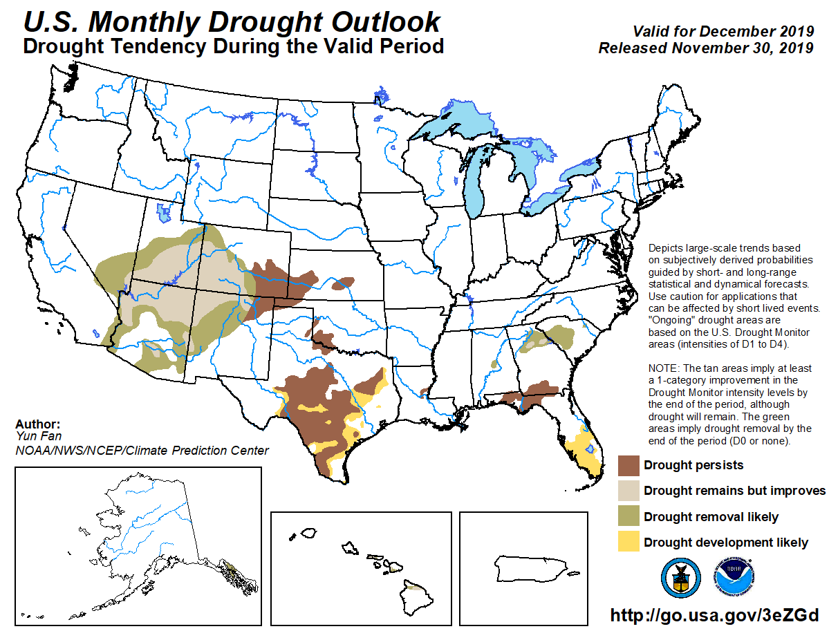
above-, below- and near-normal moisture in the state. CPC’s December drought
outlook indicated persistence of drought in those areas where it was noted in
November’s final Drought Monitor map.
Gary McManus
State Climatologist
Oklahoma Mesonet
Oklahoma Climatological Survey
(405) 325-2253
gmcmanus@mesonet.org
December 2 in Mesonet History
| Record | Value | Station | Year |
|---|---|---|---|
| Maximum Temperature | 83°F | BURN | 2021 |
| Minimum Temperature | -1°F | MIAM | 2006 |
| Maximum Rainfall | 2.15″ | BROK | 2020 |
Mesonet records begin in 1994.
Search by Date
If you're a bit off, don't worry, because just like horseshoes, “almost” counts on the Ticker website!