Ticker for October 25, 2019
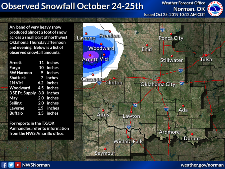
                UPDATE: We are now hearing from the Norman National Weather Service office that
the cooperative observer in Arnett is reporting 13 inches of snow, a new daily
snowfall record in October for the state of Oklahoma!


MESONET TICKER ... MESONET TICKER ... MESONET TICKER ... MESONET TICKER ...
October 25, 2019   October 25, 2019   October 25, 2019   October 25, 2019


Tie goes to the runner


The 11 inches reported by the NWS cooperative observer in Arnett ties the record
for daily October snowfall in Oklahoma, first set by Regnier in the far western
Panhandle back on this same date in 1997. The Panhandle has a bit of an advantage
with its higher elevation and access to deep cold air needed for snow production.
For the main body of the state, the widespread heavy snow reports are quite
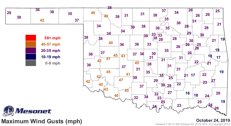
remarkable. And obviously with the winds being what they are, the drifts are
probably much higher.


Dr. J. D. Carlson, OSU fire meteorologist and our OK-FIRE Program Manager,
reported hearing thunder during an OK-FIRE workshop he was leading in Woodward
yesterday, so you add a bit of convection to the mix and the higher snow totals
make a bit more sense. For this time of the year, that is. The Amarillo NWS
office reports 5 inches from near Slapout in Beaver County, but totals diminish
the farther west you go.

Here are some of the higher daily October historical totals from across the state.

Location        Snow Total            Date
----------------------------------------------
Regnier            11 in.           10/25/1997
Boise City          9 in.           10/31/1991
Kenton              8 in.           10/21/1996
Boise City          8 in.           10/25/1997
Goodwell            6 in.           10/08/1970
Hooker              5 in.           10/08/1970
Gate                5 in.           10/08/1970
----------------------------------------------

Kenton reported 15 inches of snow on the ground on Oct. 26, 1997, but that
was an accumulated value over the 25th and 26th, so no daily total to work with
there. Described here by former Oklahoma Associate State Climatologist Howard
Johnson.

"Those averages were inflated by a freak snowstorm on October 25 and 26,
1997 that dropped 15 inches of snow on Kenton. As many as 15,000 head of
cattle across the panhandle died during that snowstorm."

Not the earliest snowfall in the state either. That prize goes to Boise City,
as again described by Howard Johnson:

"Snow is rare in September, But Boise City reported 4 inches for the
month in 1984 and Kenton recorded 3 inches on September 17, 1971, the
earliest snowfall in the state since at least 1910."

The snow has caused lots of trouble across NW OK, with road closings and
electric utility outages. It hasn't been a Festivus for the restuvus either,
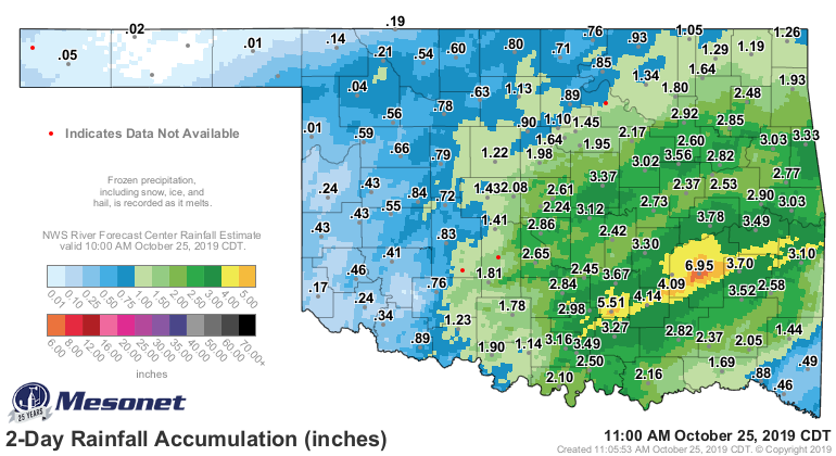
with lots of heavy rain and gale force winds. Not sure who Gale is, but I wish
she'd knock it off.


So a historic snowfall, especially for downstate (what the Panhandle folks
call the main body of Oklahoma). Get ready to do this again early next week.
Maybe not the snow, but even colder weather.

Gary McManus
State Climatologist
Oklahoma Mesonet
Oklahoma Climatological Survey
(405) 325-2253
gmcmanus@mesonet.org
October 25 in Mesonet History
| Record | Value | Station | Year |
|---|---|---|---|
| Maximum Temperature | 93°F | MANG | 2014 |
| Minimum Temperature | 18°F | KENT | 2019 |
| Maximum Rainfall | 3.91″ | MCAL | 2023 |
Mesonet records begin in 1994.
Search by Date
If you're a bit off, don't worry, because just like horseshoes, “almost” counts on the Ticker website!