Ticker for October 1, 2019
MESONET TICKER ... MESONET TICKER ... MESONET TICKER ... MESONET TICKER ...
October 1, 2019 October 1, 2019 October 1, 2019 October 1, 2019
Wait for it
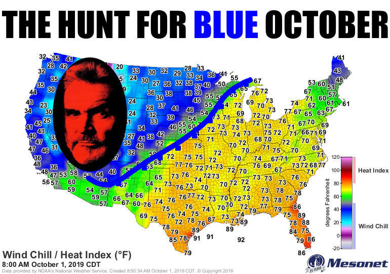
One more day of Augtember (let's call it "Ougust"..."Octgust?"..."Augtober??"),
well, you get the idea. Then the fall hits the fan with a series of 3 cold
fronts late on Wednesday, again later on Saturday, and again late on Sunday...
each one stronger than the last. The Norman NWS office gave us a pretty good
idea of the diminished temperature roller coaster that should help usher us
into autumn.
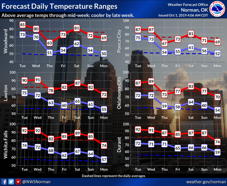
The front will transition through Wednesday night through Thursday, giving us
a temperature range from the 40s to the 90s over that 12-hour time frame.

And that will also bring us a bit of unsettled weather, as cold fronts are
wont to do, including some more rain chances.
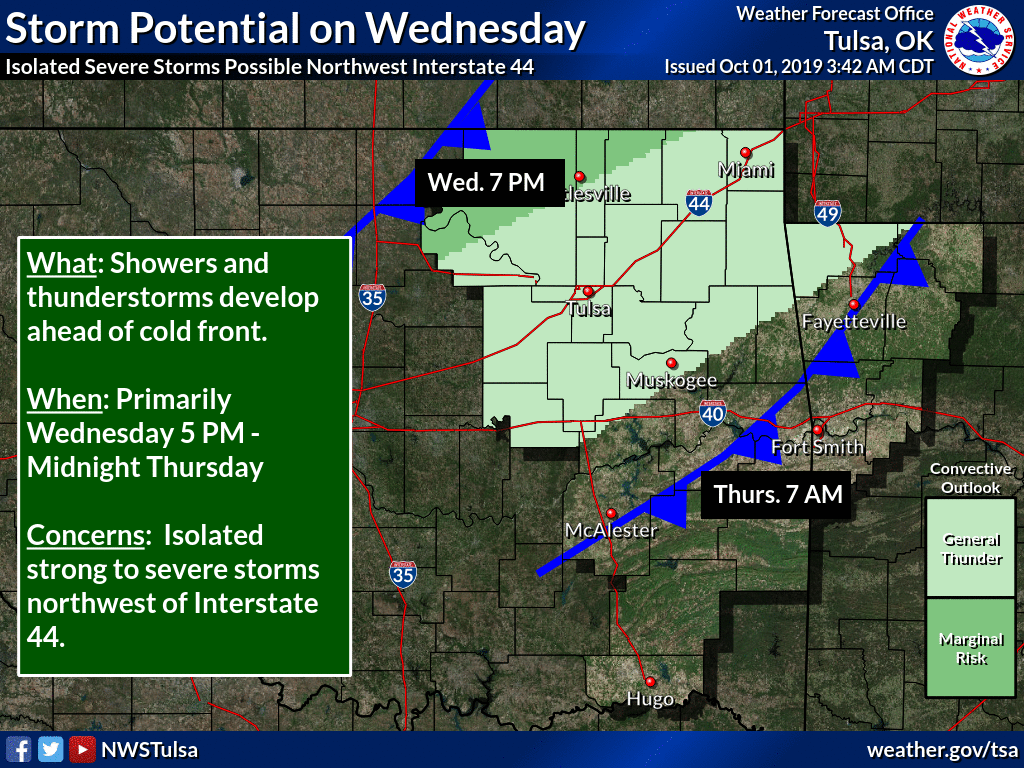
Wednesday could be bumpy with that first cold front. Severe weather is
definitely a possibility.

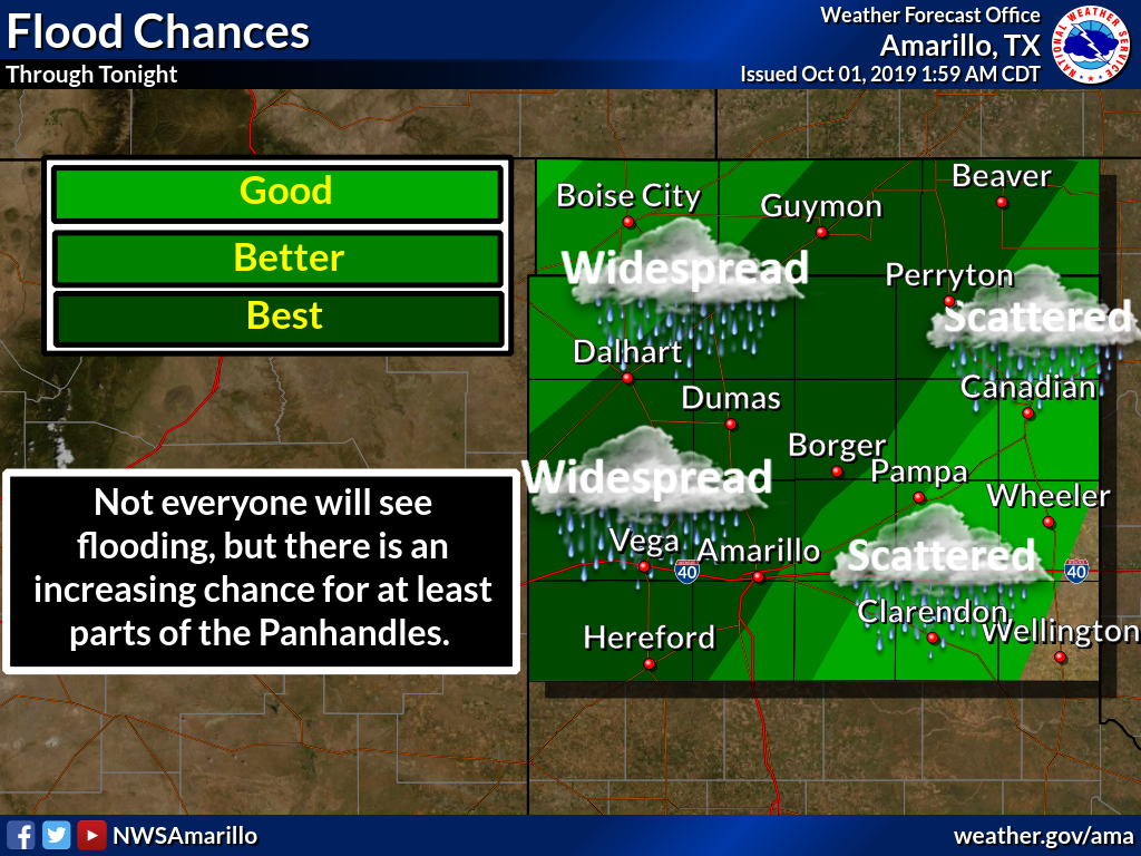
Meanwhile, the Panhandle (yes, THAT Panhandle) is dealing with possible flooding
due to tropical depression what's-her-name...Narda.
---------------------------------------------------------------------------------
Summer Weather Scorches September
Oct. 1, 2019
September normally sees at least one or two decent cold fronts to whet the
appetite for fall. Mother Nature had different plans this year, however, steering
summer right past the beginning of autumn and giving Oklahoma its fourth
warmest September since records began in 1895. The Panhandle experienced its
warmest September on record, while the north central, southeast, and west
central areas of the state had their second warmest. Tulsa ended with their
second warmest September on record at 81.2 degrees, 8.2 degrees above normal.
Oklahoma City’s 78.8 degrees earned them a ranking of seventh warmest at 4.9
degrees above normal. Gage suffered its warmest September since its records
began, dating back to 1904. At least eight other NWS sites eclipsed their
previous September monthly temperature records.
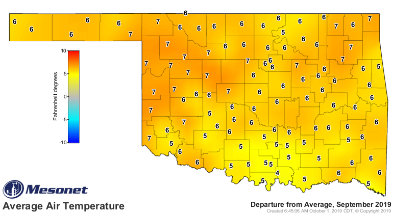
The statewide average temperature of 79.4 degrees – as observed by the Oklahoma
Mesonet – was a whopping 7.1 degrees above normal. Only 1931’s 80.1 degrees,
1998’s 79.6 degrees, and 1939’s 79.5 degrees were higher.
Triple-digit temperatures occurred as late as Sept. 27 with the Buffalo and
Freedom Mesonet sites registering 101 and 100 degrees, respectively. The
month’s highest temperature of 103 degrees occurred at Grandfield on the
seventh. Twenty-eight readings of at least 100 degrees were reported by the
Mesonet during the month. The month’s lowest reading was 43 degrees at Eva
on the 23rd. The heat index was not as unbearable as it had been over the
previous couple of months, but it did hit the century mark 596 times at the
Mesonet’s 120 sites. A heat index of 106 degrees topped that category at six
different sites. The first nine months of the year ended at 63.7 degrees, 0.3
degrees above normal to rank as the 50th warmest January-September on record.
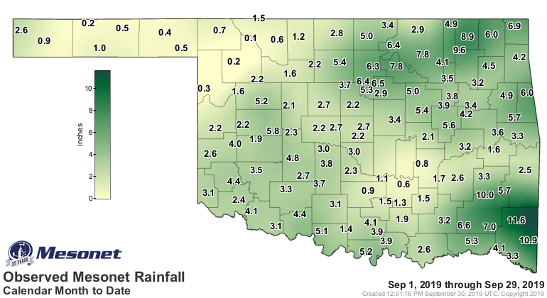
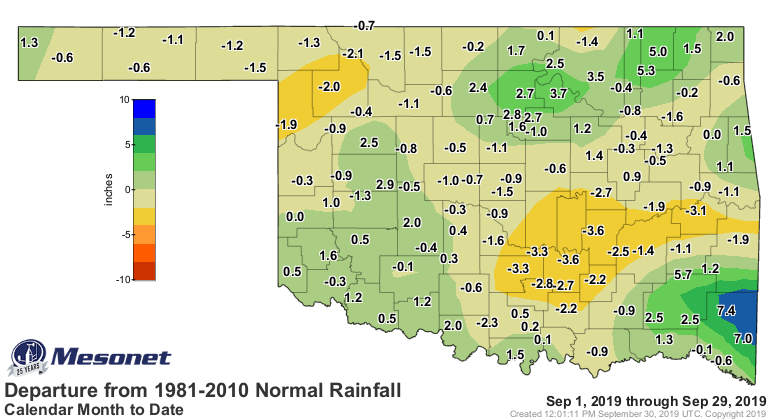
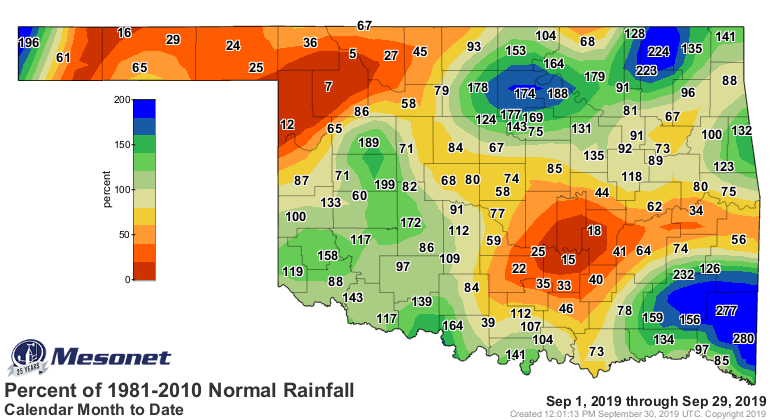
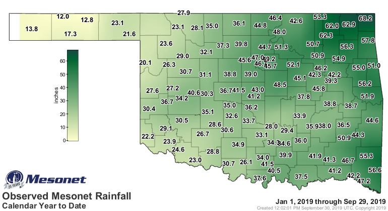
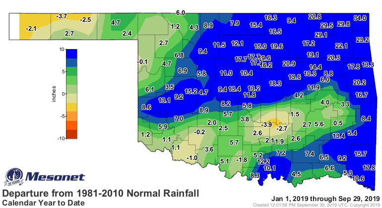
Rains were both plentiful and scarce, depending upon location. The statewide
average of 3.43 inches was a tenth of an inch below normal to rank as the 51st
wettest September on record. Deficits of 2-4 inches were the rule across the
northwest and parts of central and southeast Oklahoma. Meanwhile, surpluses of
2-5 inches occurred in the north central, northeast and southeast sections of
the state. Parts of McCurtain County received more than 10 inches while the far
northwest struggled to eclipse a half-inch. The Mesonet’s highest recorded
total was 11.6 inches at Mt. Herman in McCurtain County. Freedom in Woodward
County recorded a tenth of an inch to bring up the rear. The year continued on
pace to finish as one of the top-10 wettest on record with a January-September
statewide average of 37.01 inches, 8.62 inches above normal, the eighth wettest
such period since records began in 1895.

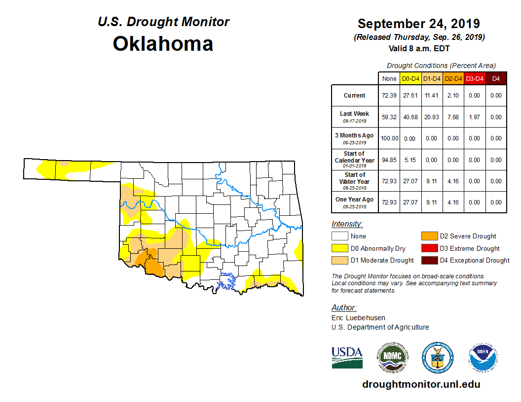
Drought continued a slow decline after peaking in late August. By the end of
September, drought had been reduced to less than 12% of the state according to
the U.S. Drought Monitor, down from a high of 24% on August 20. Most of the
drought was considered moderate in intensity, centered on far southwestern
Oklahoma. There was a small area of severe drought in the far southwest that
had been downgraded from extreme drought the previous week. The Drought
Monitor’s intensity scale slides from moderate-severe-extreme-exceptional, with
exceptional being the worst classification. Moderate drought increased slightly
across the northwest in Ellis, Roger Mills and Woodward counties. Additionally,
16% of the state was considered in “abnormally dry” conditions, a precursor to
drought intensification or an area recovering from drought but not yet back to
normal.
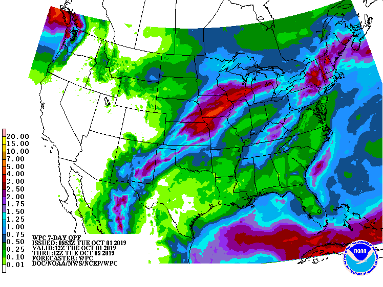
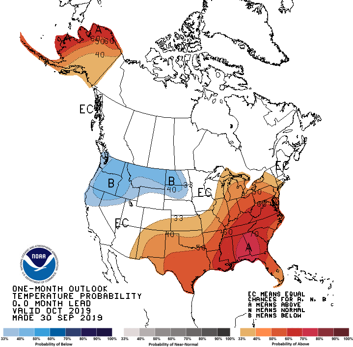
The October temperature outlook from the Climate Prediction Center (CPC)
indicates increased odds for above normal temperatures across the southeastern
half of the United States, including Oklahoma. Those odds are greater across
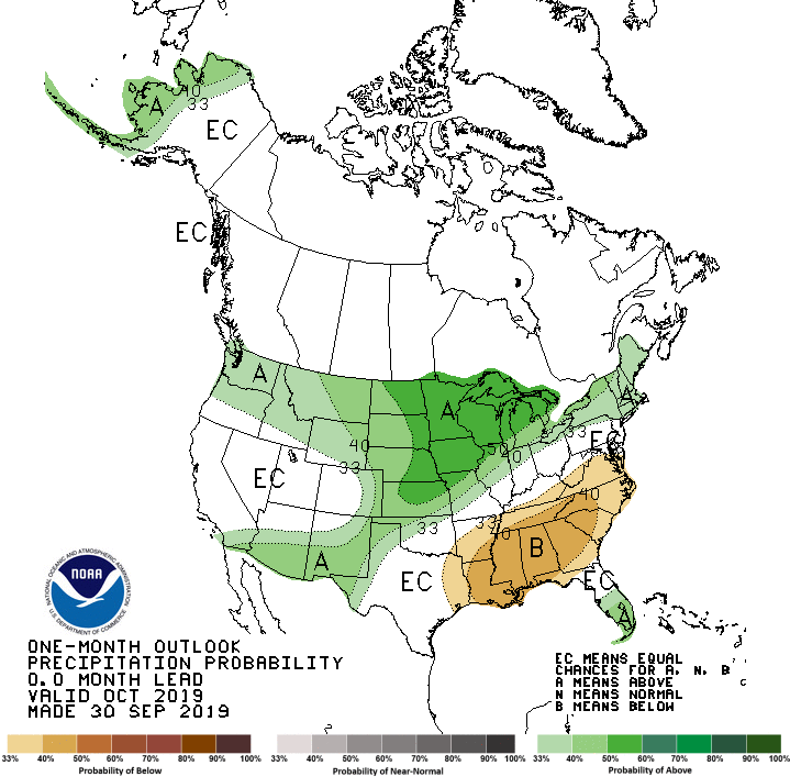
the southern two-thirds of the state. The October precipitation outlook shows
increased odds for above normal precipitation across the northwestern one-third
of Oklahoma, with better chances in the Panhandle and far northwest. CPC’s
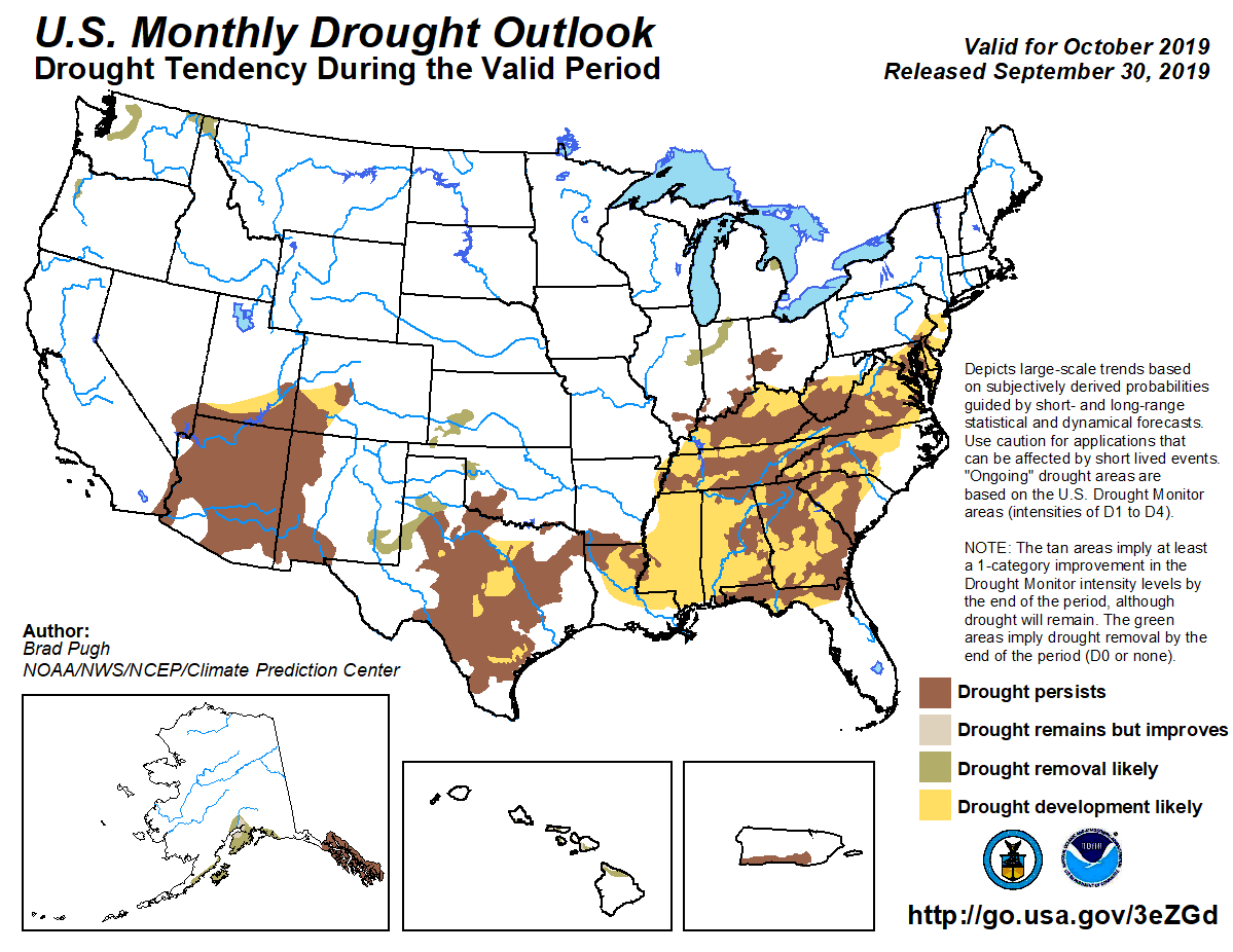
October drought outlook anticipates drought removal across the northwest and
Panhandle, but persistence in southern Oklahoma.
Gary McManus
State Climatologist
Oklahoma Mesonet
Oklahoma Climatological Survey
(405) 325-2253
gmcmanus@mesonet.org
October 1 in Mesonet History
| Record | Value | Station | Year |
|---|---|---|---|
| Maximum Temperature | 99°F | SLAP | 2000 |
| Minimum Temperature | 34°F | KENT | 2009 |
| Maximum Rainfall | 3.52 inches | ERIC | 1998 |
Mesonet records begin in 1994.
Search by Date
If you're a bit off, don't worry, because just like horseshoes, “almost” counts on the Ticker website!