Ticker for August 1, 2019
MESONET TICKER ... MESONET TICKER ... MESONET TICKER ... MESONET TICKER ...
August 1, 2019 August 1, 2019 August 1, 2019 August 1, 2019
Oh Fudge
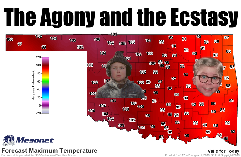
No, I really did say "fudge." Nice try, though. And I know most of you want to
hit me in the eye with a snowball, but then again, most of us would like to
get hit with a snowball right about now. At least those across eastern Oklahoma
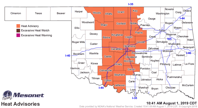
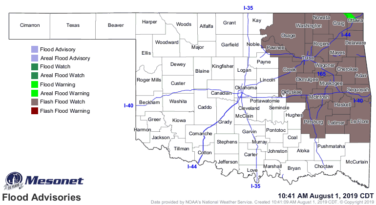
get a cooldown and some rain today, while the rest of us bake. In pure #Oklahoma
fashion, we have flood watches and warnings in the east, and a heat warning in
the west.
That's pretty much how it's gonna go for today, then the restuvus get a festuvus,
errrr, the rest of us get the same cooldown this weekend, then we're back at the
summer deal next week.
But let's talk about July. Wait, you can't hear me talk. What a horrible idea.
How about we read about July instead. Click below to read about a return to
drought, some whopping heat indices, our tornado total went UP (now 2nd highest
on record), and more drought appears likely!
What? Yeah, that's what I THOUGHT you said. Get in the car.
_________________________________________________________________________________
Drought Returns During July
Aug. 1, 2019
Drought returned to the state for the first time since March 12, a stark reminder
that spring deluges can quickly be forgotten during the unforgiving Oklahoma
summer. The abrupt end of the moisture actually extended back to mid-June in some
areas, but the deficits widened further during July. The lack of rain coincided
with intermittent periods of hot, windy weather. Those sporadic bouts of
extreme summer conditions helped to accelerate the drought development process,
despite the month being cooler than normal overall. Severe weather still made
its presence known with reports of the customary culprits, including high winds,
large hail, and flash flooding. There were no official reports of tornadoes.
The preliminary Oklahoma twister count for 2019 stood at 129 at the end of
July, the second highest total since accurate records began in 1950. The
highest total of 145 occurred in 1999.
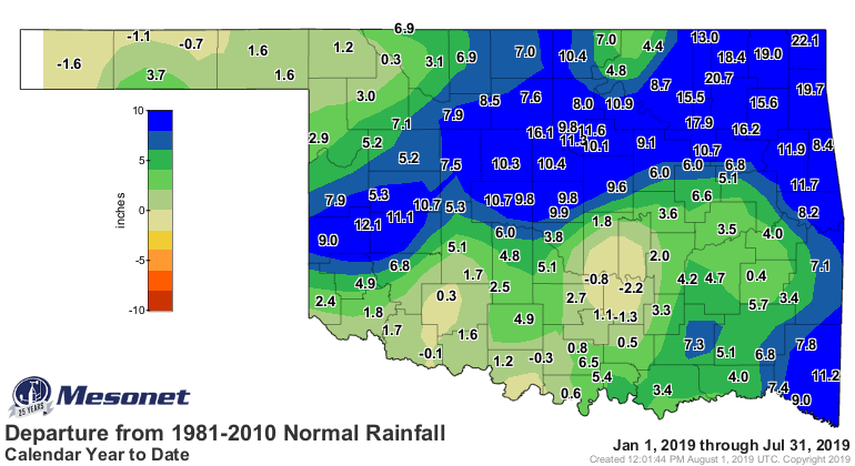
According to preliminary data from the Oklahoma Mesonet, the statewide average
rainfall total was 1.63 inches, 1.25 inches below normal, to rank as the 29th
driest July since records began in 1895. Rainfall fortunes varied widely across
the state. Substantial rains fell across much of eastern Oklahoma, where totals
of 3-5 inches were common. Copan led the Mesonet at 5.81 inches, with Wister a
close second at 5.35 inches. Significant deficits reigned across much of
central and western Oklahoma.
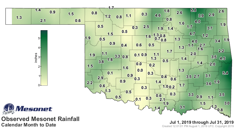
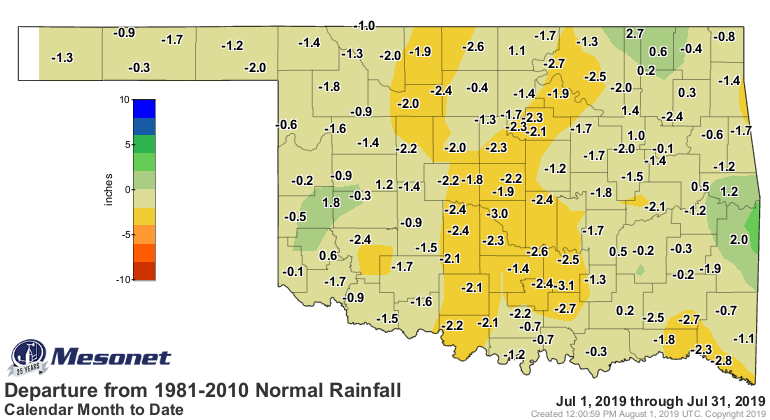
Forty-five of the Mesonet’s 120 stations recorded less than an inch of rain for
the month, while 87 received less than 2 inches. Chickasha had the lowest total
at 0.03 inches, although Minco was close behind with 0.04 inches. The Oklahoma
City official observing site at Will Rogers Airport recorded 0.06 inches, tied
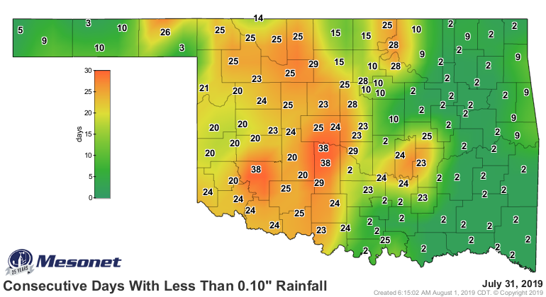
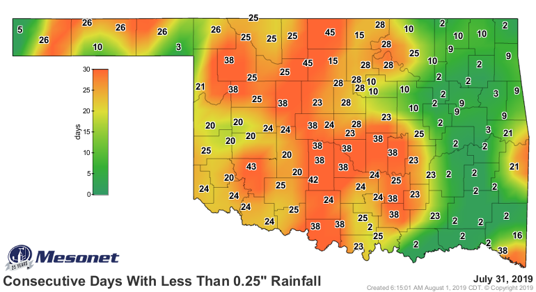
for its fourth driest July on record. By the end of July, parts of north
central Oklahoma had gone 45 days without at least a quarter-inch of rainfall.
That streak extended to 38 days across central and southwestern Oklahoma.
Chickasha, Hobart and Minco had gone 38 consecutive days without at least a
tenth of an inch.
The first seven months of the year were still extremely wet with a January-July
statewide average of 27.86 inches, a surplus of 5.95 inches and the ninth
wettest such period on record.


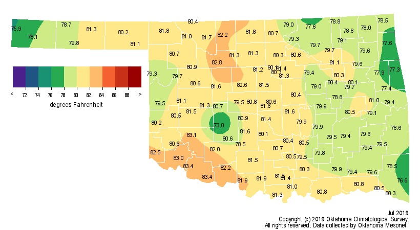
The statewide average temperature was 80.2 degrees, 1.3 degrees below normal
to rank as the 34th coolest July on record. Several cold fronts helped keep
the extreme heat confined within shorter windows. The strongest of those fronts
moved through the state on the 22nd, dropping high temperatures into the low
80s. Lows in the 50s were common, and Camargo dropped to 48 degrees on the 24th
for the month’s lowest reading. More than a dozen low temperature records were
set across the state that morning. Extreme heat still visited at times,
however. Kenton recorded July’s highest temperature at 107 degrees on the 19th.
The Mesonet measured heat index values of at least 110 degrees 154 times during
the month, maxing out at 116 degrees at Burneyville on July 10. The year
continues to run on the cool side. The January-July statewide average was 58.6
degrees, a degree below normal, to rank as the 42nd coolest such period on
record.

Nearly 6% of the state was in moderate drought according to the July 30 U.S.
Drought Monitor report, and another 13% was considered “abnormally dry,” a
drought precursor. Those designations cover most of the southwestern quarter
of the state, with another dollop centered over Ellis County in the northwest.
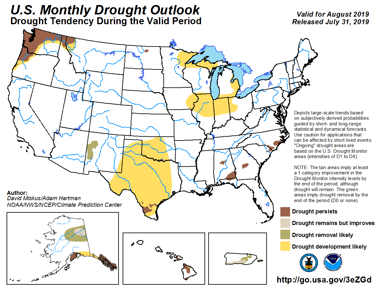
Drought development is considered likely across the western two-thirds of the
state through the end of August according to the Climate Prediction Center’s
(CPC) monthly drought outlook. That drought development would be in addition to
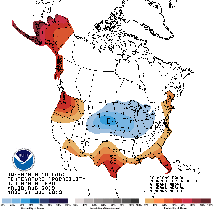
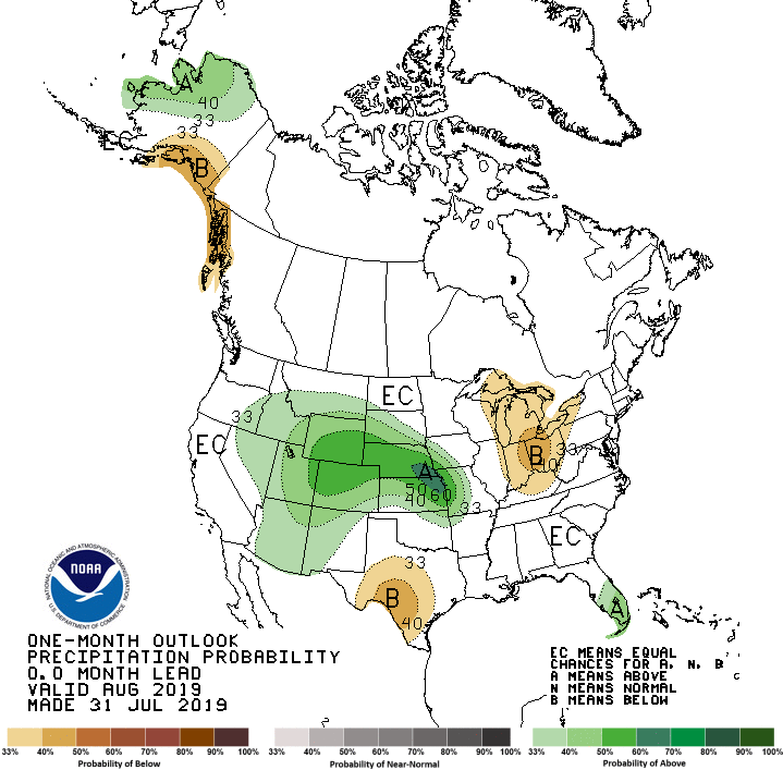
those areas that saw drought advance by the end of July. CPC’s temperature and
precipitation outlooks for August indicate increased odds of above normal
temperatures across the southwestern one-third of the state, and above normal
precipitation over far northeastern Oklahoma.
Gary McManus
State Climatologist
Oklahoma Mesonet
Oklahoma Climatological Survey
(405) 325-2253
gmcmanus@mesonet.org
August 1 in Mesonet History
| Record | Value | Station | Year |
|---|---|---|---|
| Maximum Temperature | 115°F | KIN2 | 2012 |
| Minimum Temperature | 53°F | KENT | 2018 |
| Maximum Rainfall | 5.04 inches | NOWA | 1995 |
Mesonet records begin in 1994.
Search by Date
If you're a bit off, don't worry, because just like horseshoes, “almost” counts on the Ticker website!