Ticker for July 2, 2018
MESONET TICKER ... MESONET TICKER ... MESONET TICKER ... MESONET TICKER ...
July 2, 2018 July 2, 2018 July 2, 2018 July 2, 2018
June's in the books
Summer's fickleness is now in full swing, and we are fully at the mercy of the
placement of the heat dome. As it slides back and forth across the country, when
it's over us, we'll bake. When it slides to the east or west (with some north
and south in there), we may get a cooldown with a chance of summer-time rains.
You know the kind, where a storm pops up, rains like crazy over one spot, then
dies suddenly. Soooooo, prepare for that scenario as we go through the next week
or so. We'll see chances for rain tonight out west, then as we get into Wednesday
through the weekend. But again, we're going to bake for the next few days
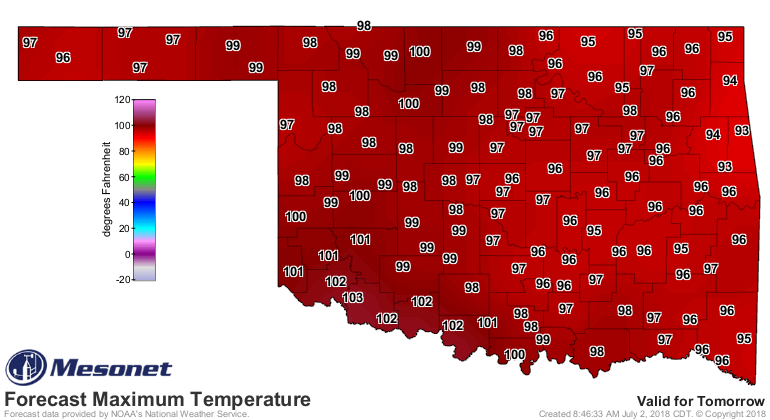
before a possible not-as-hot weekend. The difference in the high temperature
maps for Tuesday and Thursday show the movement of that heat dome and the
effects.

The kicker is just how moist the atmosphere is, thanks to a wide open flow from
the Gulf.
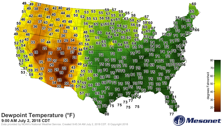
All that moisture, combined with heat and a few storm triggers here and there
give us a chance for some rain. With that much moisture, it's almost hard to
stop it.
Now we turn our eyes BACK to June, another hot month for all, and wet for some,
and really REALLY dry for a few.
On with the show, this is it!
--------------------------------------------------------------------------------
June Rains Ease Drought
The Gulf of Mexico was in a giving mood throughout June, feeding a deep plume of
tropical moisture to a succession of storm systems moving across Oklahoma. Not
all areas were quite as fortunate as others, but a substantial portion of the
state received significant, drought-reducing rainfall. The eastern Panhandle even
got an unexpected boost from the remnants of hurricane Bud as it made its journey
through the Gulf of California into the Northern Plains. The most prolific June
rains fell from the eastern Panhandle through central and east central Oklahoma.
Readings of 6-8 inches were common along that corridor with the Oklahoma City
East Mesonet site leading the way at 8.74 inches. Beaver received 7.18 inches
– nearly a third of their normal annual total – and 8.27 inches fell at
Wilburton. Eighteen of the Mesonet’s 120 sites recorded at least 6 inches of
rain and 40 reported at least 5 inches.
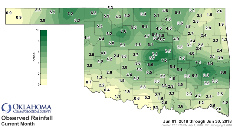

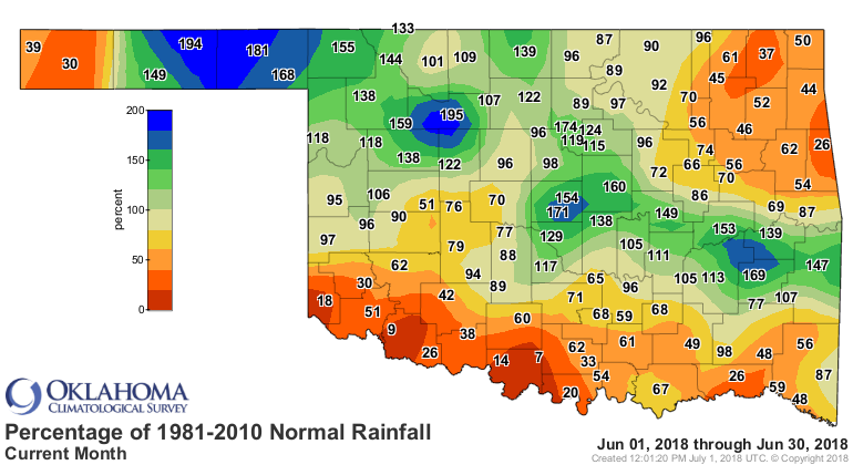
Significant deficits occurred along the periphery of the state. Areas along the
Red River, the far northeast, and the western Panhandle fell 2-4 inches below
normal. Ringling received a paltry 0.3 inch, while another 15 sites reported
less than 2 inches. The statewide average was 4.07 inches according to
preliminary data from the Mesonet, 0.45 inch below normal to rank as the 55th
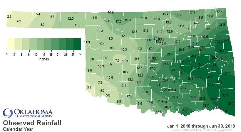
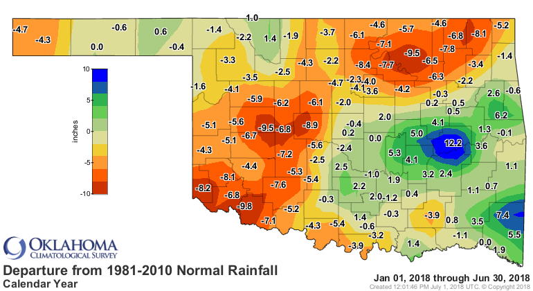
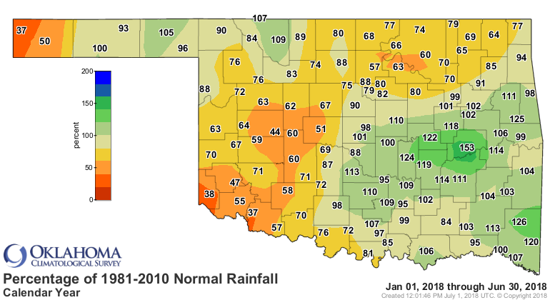
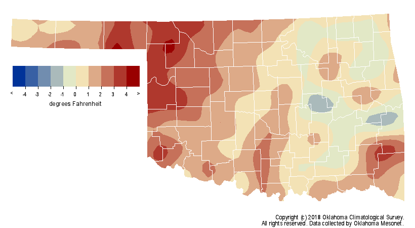
wettest June on record. Year-to-date rainfall remained quite variable, from
more than 12 inches above normal in east central Oklahoma to 8-10 inches below
normal in the southwest and northeast. The statewide average total of 16.96
inches for the first 6 months of 2018 was 2.07 inches below normal, the 56th
driest January-June on record.
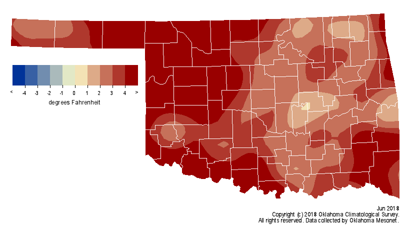
Despite the rainy weather, June was still on the hot side. According to
preliminary data from the Oklahoma Mesonet, the statewide average temperature
finished at 80.1 degrees, 3.6 degrees above normal to rank as the 15th warmest
June on record.
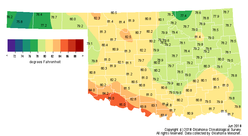
That lofty mark, combined with the warmest May in Oklahoma history, propelled
the May-June period to the warmest on record as well at 77.5 degrees. The
previous record of 77.4 degrees was set in 1911. The month’s highest
temperature was 106 degrees, recorded at several Mesonet sites on three
different dates. The combination of abundant rainfall, Gulf moisture and heat
resulted in oppressive conditions at times. The Mesonet’s 120 stations recorded
heat index values of at least 110 degrees 84 times during June, with a high of
114 degrees at Nowata on the 28th. Fifty-two of those readings occurred June
27-28. The Eva Mesonet site recorded the lowest temperature, 45 degrees, on
June 3. The year thus far continued on the warm side with a statewide average
of 56.8 degrees, a degree above normal to rank as the 27th warmest January-June
on record.

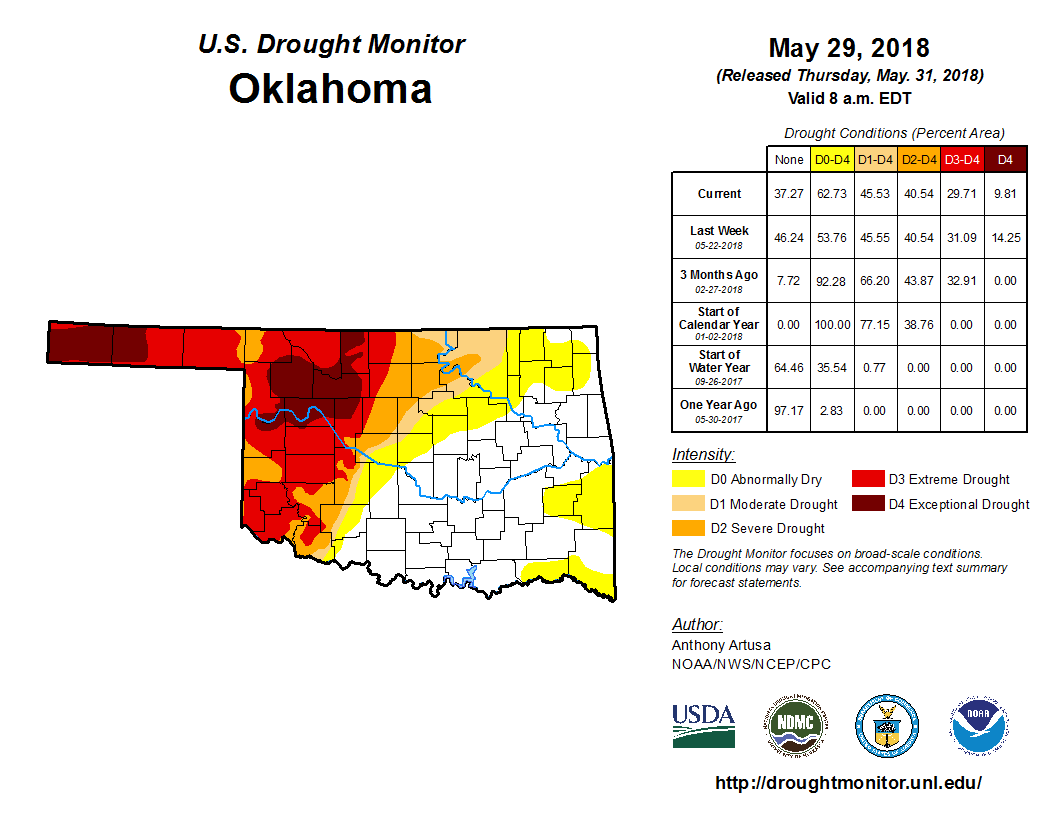
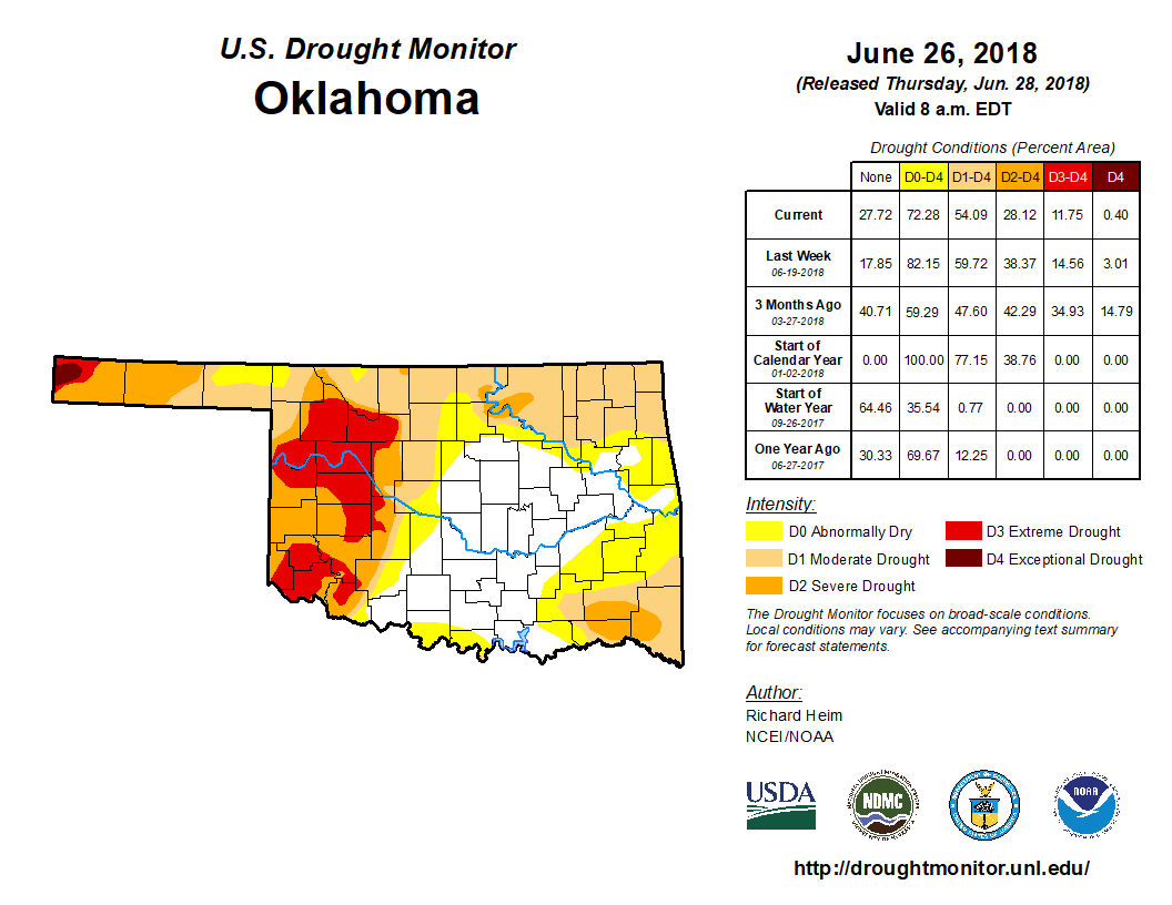
Mother Nature made significant progress combating the drought during June, at
least in the case of its severity. The percentage of the state in some level of
drought actually increased by about 9 percent from the end of May, mostly
across eastern Oklahoma. The portion in at least “severe” drought decreased,
however, from 41 percent to 28 percent. “Exceptional” drought was virtually
eliminated during June, down from 10 percent of the state to start the month.
The Drought Monitor’s intensity scale slides from moderate-severe-extreme-
exceptional, with exceptional being the worst classification.
The temperature and precipitation outlooks from the Climate Prediction Center
(CPC) indicate the possibility of more hot, dry weather ahead. The maps for
July show increased odds for above normal temperatures and below normal
precipitation across the state.
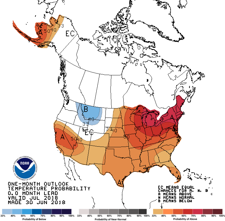
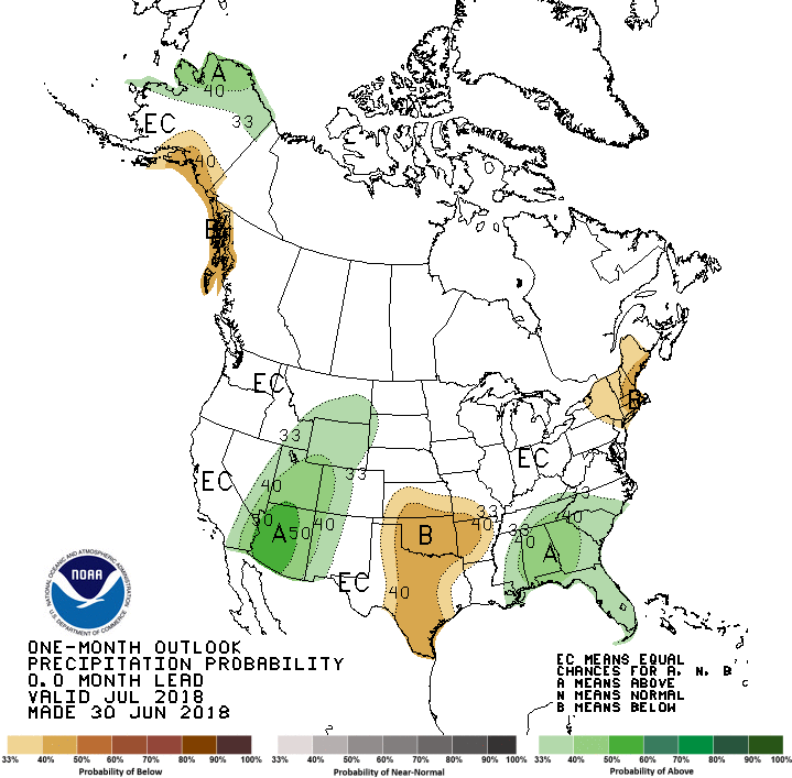
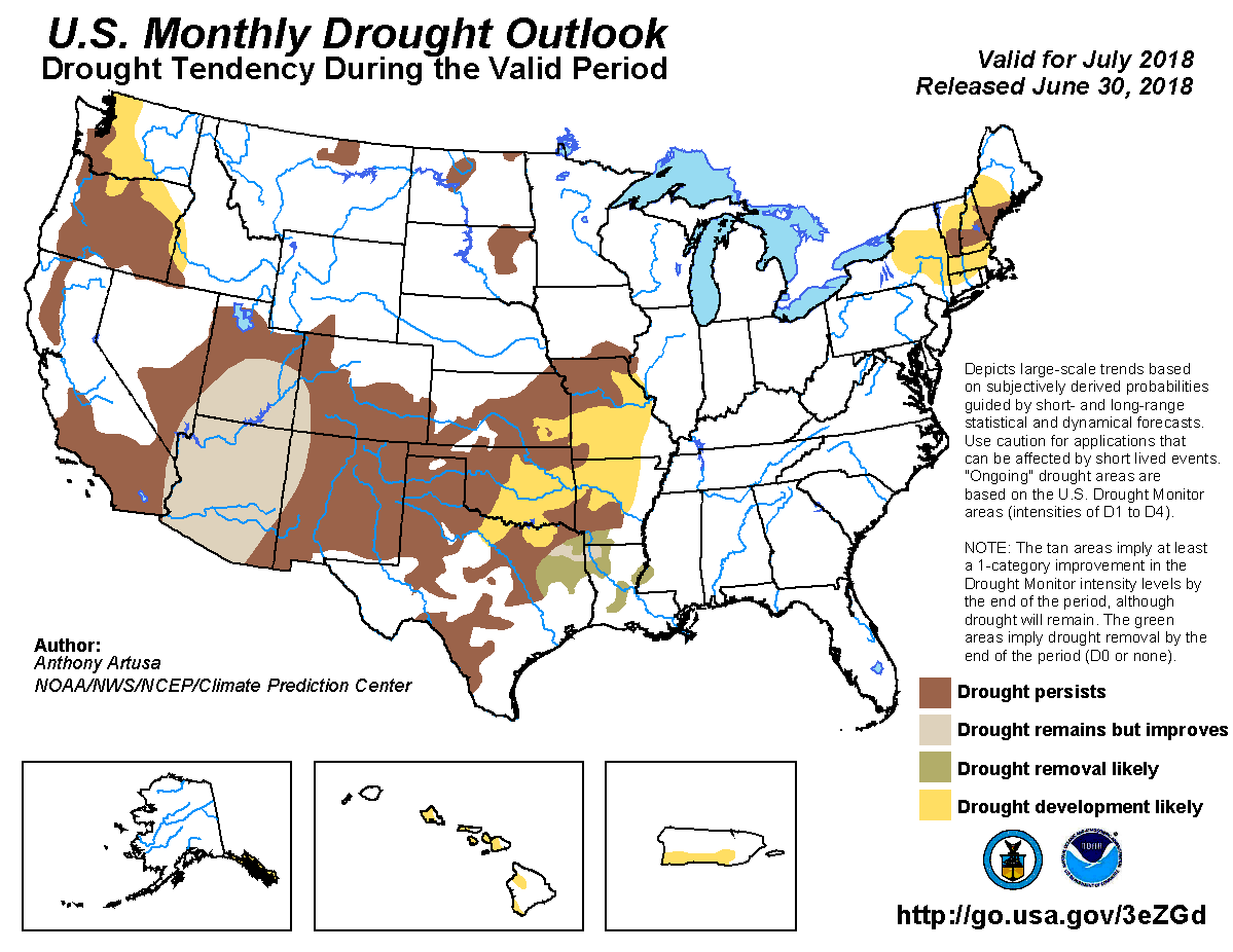
Unfortunately, that does not bode well for Oklahoma’s ongoing drought. CPC’s
U.S. Monthly Drought Outlook for July sees drought persisting or intensifying
where it already exists, with drought development “likely” across the rest of
the state.
Gary McManus
State Climatologist
Oklahoma Mesonet
Oklahoma Climatological Survey
(405) 325-2253
gmcmanus@mesonet.org
July 2 in Mesonet History
| Record | Value | Station | Year |
|---|---|---|---|
| Maximum Temperature | 107°F | KIN2 | 2024 |
| Minimum Temperature | 49°F | SEIL | 2013 |
| Maximum Rainfall | 6.98 inches | FITT | 2017 |
Mesonet records begin in 1994.
Search by Date
If you're a bit off, don't worry, because just like horseshoes, “almost” counts on the Ticker website!