Ticker for April 11, 2018
MESONET TICKER ... MESONET TICKER ... MESONET TICKER ... MESONET TICKER ...
April 11, 2018 April 11, 2018 April 11, 2018 April 11, 2018
Sinter? Wummer?
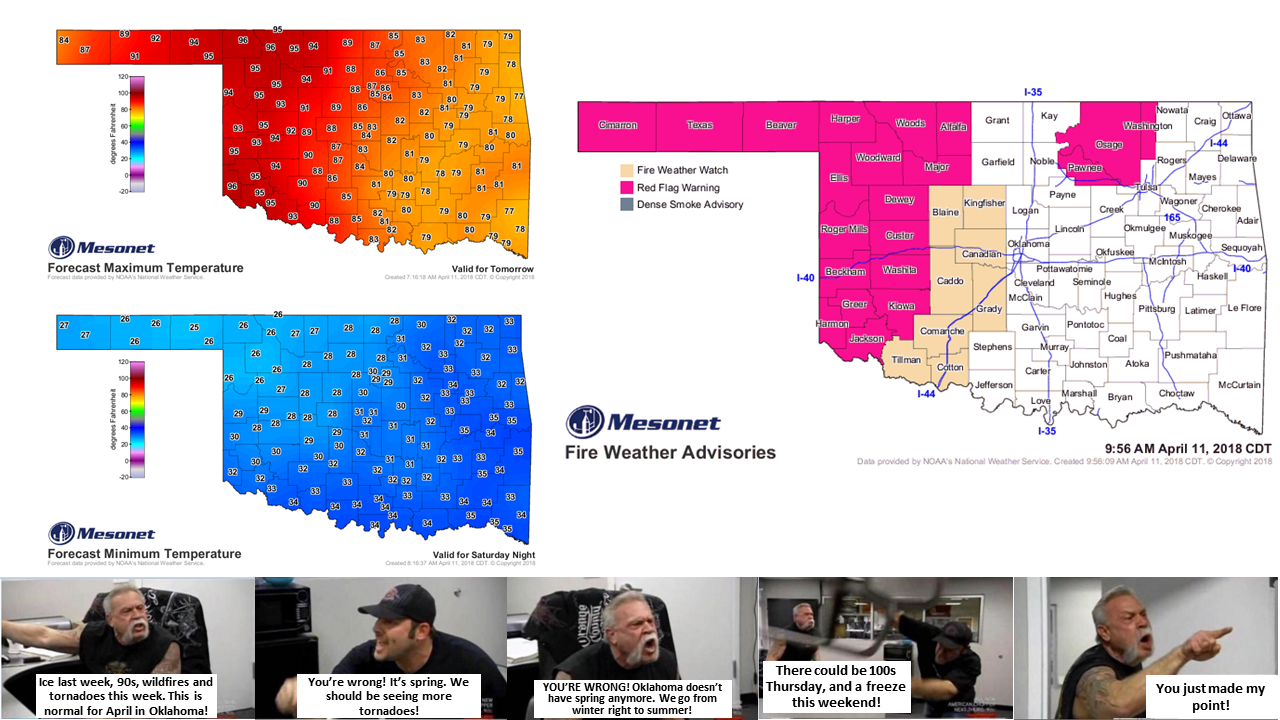
In a cantankerous mood, are ya? Don't know what to get down out of the closet, and
what to put up for good? Well, you should probably wait because Mother Nature is
going to bring us a load of summer and winter for the next few days. Do we still
see spring in Oklahoma? Sure we do. This week it will be for a 7-minute period
on Friday, from 1:01-1:08pm, but only in a very select section of the state that
I shall not mention (ahem...Buffalo, of course).
Yes, here comes another powerful storm system (i.e., windmaker) that will kick
up the fire danger, desiccate western Oklahoma, and provide some rain and storms
for eastern Oklahoma. Where have you heard that before? So prepare for bigtime
fire danger across the west and possible severe weather to the east. Let's top
it off with another freeze on Saturday and Sunday, shall we?
Norman NWS has a good take on the fire danger for the next week. Looks like a
doozy.
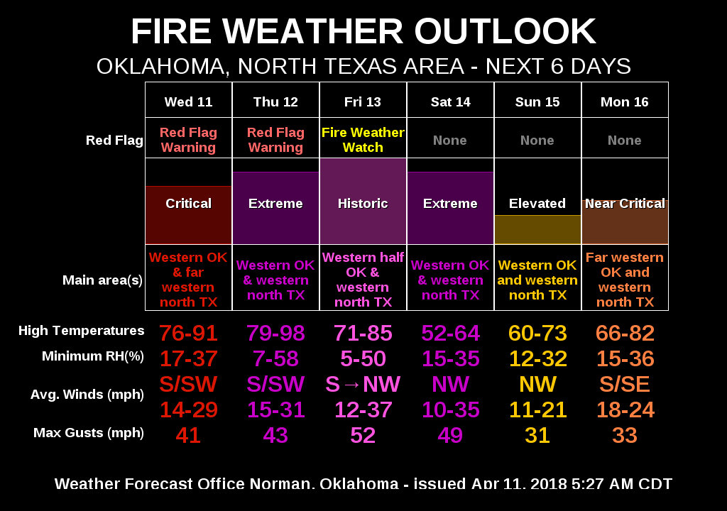
Uhhhh, "Historic" fire danger on Friday? Packing the car, headed to the lake
on Friday. The MIDDLE of the lake.
And Tulsa has a good read on Friday's tumult. This will be the day of BIGTIME
everything. Storms, fire, wind, etc.
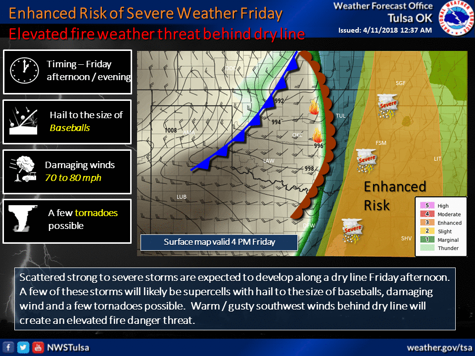
Here's there description:
"On Friday, a strong storm system will move into the Plains region,
leading to an increase in the severe thunderstorm potential, as
well as continued elevated fire weather conditions. Thunderstorm
chances will increase beginning Thursday night and increase during
the day Friday as a cold front and dryline approach from the west.
Strong to severe thunderstorms should develop by early to mid
afternoon Friday well ahead of the surface boundaries. Additional
development is expected on the dryline by late afternoon and into
the evening hours. Storms along the dryline will have the potential
to become supercells with the threat for baseball size hail, damaging
winds, including the possibility for a few tornadoes. The severe
weather threat will shift east of the region shortly after midnight.
Behind the dry line, elevated fire weather conditions will develop
Friday afternoon as dry and gusty southwest winds develop over
portions of northeast Oklahoma. Areas along and west of Highway 75
will be most likely to see elevated conditions."
Here's that area of severe weather concern, mapped out by the Storm Prediction
Center.
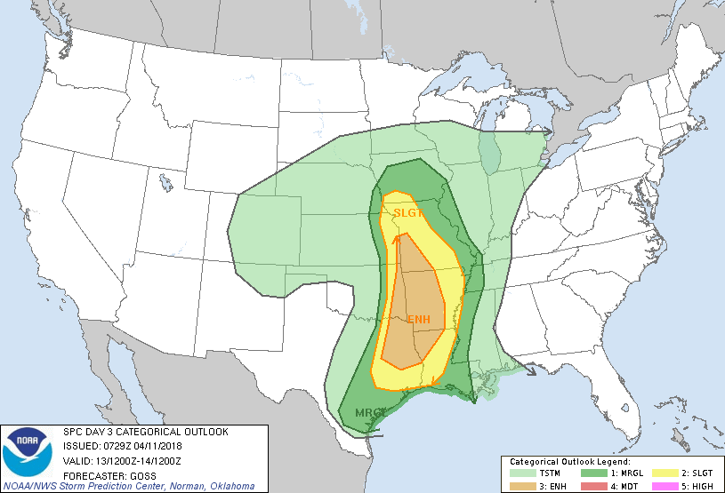
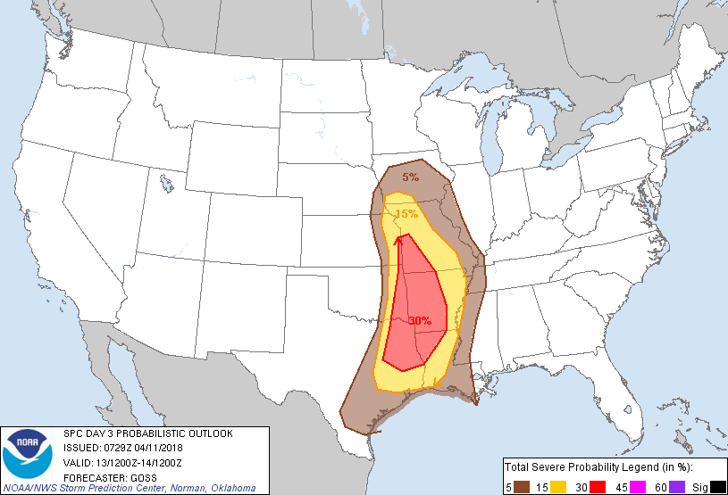
Yikes! Folks in eastern Oklahoma need to stay weather aware as Friday draws
near, just as the rest of the state needs to stay FIRE aware starting today.
Remember, this is all on the backdrop of extreme-exceptional drought across
the NW half of the state, where even the good rains of February and March are
starting to age out in the face of the heat and wind.
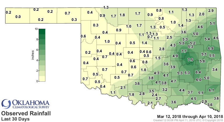
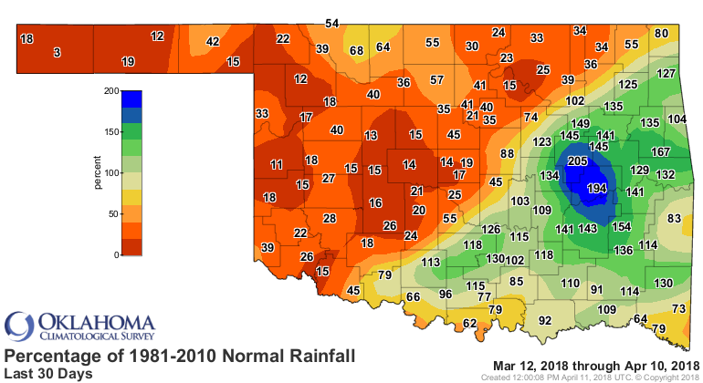
This has been going on for over 6 months, so the last 30 days are just
exacerbating the impacts.
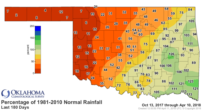
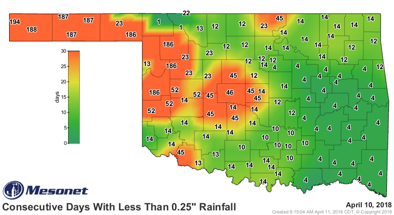
And we're now at 195 days (add today to the map) for the western Panhandle to
see at least a quarter-inch of rain in a single day.
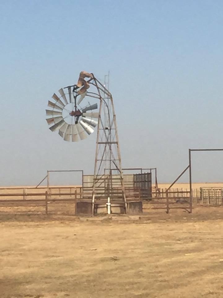
As they tell me out that way, it's been so long since they've seen a rain,
even their windmills are wilting!
Gary McManus
State Climatologist
Oklahoma Mesonet
Oklahoma Climatological Survey
(405) 325-2253
gmcmanus@mesonet.org
April 11 in Mesonet History
| Record | Value | Station | Year |
|---|---|---|---|
| Maximum Temperature | 96°F | ARNE | 2018 |
| Minimum Temperature | 15°F | BOIS | 2013 |
| Maximum Rainfall | 4.55 inches | VINI | 1994 |
Mesonet records begin in 1994.
Search by Date
If you're a bit off, don't worry, because just like horseshoes, “almost” counts on the Ticker website!