Ticker for April 2, 2018
MESONET TICKER ... MESONET TICKER ... MESONET TICKER ... MESONET TICKER ...
April 2, 2018 April 2, 2018 April 2, 2018 April 2, 2018
Drought Marches on
Drought "Marches" on...get it? It took a lot of thought to come up with that
one. Probably at least 95% of my brainpower. The other 5% is still trying to
figure out where my family hid the Easter eggs yesterday. I searched for hours
in the cold. They also kept yelling "April Fools" at me, and I haven't figured
out that one either. But yes, Mother Nature played a good one on us with a very
chilly Easter that has extended into today.

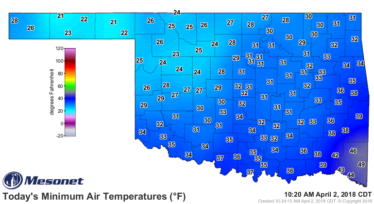
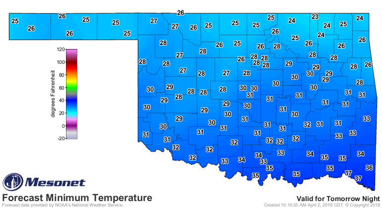
And we'll probably get a bit of a warm up before Mother Nature slams the arctic
into us again on Wednesday.
Don't expect much relief across western Oklahoma for the next 7 days. Again!
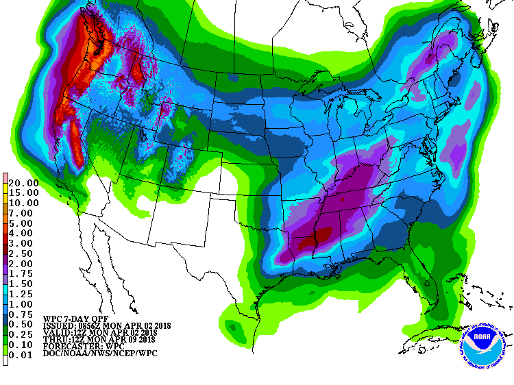
As with most of March, there appears to be little moisture for that area of
the state. Oh, speaking of March, read that month's summary below as I resume
my search for those darned Easter eggs.
Salmonella, here I come!
Gary McManus
State Climatologist
Oklahoma Mesonet
Oklahoma Climatological Survey
(405) 325-2253
gmcmanus@mesonet.org
------------------------------------------------------------------------------
March Sees Mixed Drought Fortunes
Apr. 2, 2018
Drought continued to punish western Oklahoma throughout March, even as eastern
sections saw additional relief. Similar to February, Interstate 44 served as a
rough demarcation line between the above normal totals to the southeast and
paltry offerings to the northwest. The news was dire for northwestern Oklahoma,
where precipitation deficits that began in early October 2017 strengthened
drought impacts. Fire danger rose to critical levels almost daily. Continued
damage to the winter wheat crop was reported in western Oklahoma, along with low
or empty stock ponds, desiccated soils, and struggling pastures. Severe weather
reports were sporadic, but somewhat tame for a springtime month in Oklahoma.
According to preliminary data from the Oklahoma Mesonet, the statewide average
precipitation total was 1.86 inches, 1.18 inches below normal and the 41st
driest March since records began in 1895. Most areas of the state finished
below normal except the regions just to the southeast of I-44.
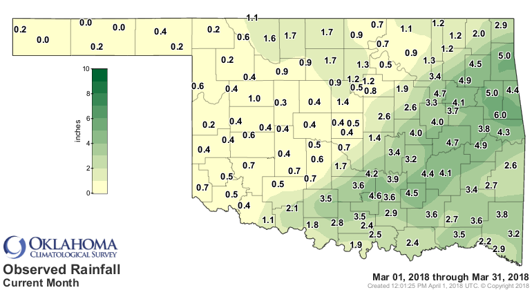
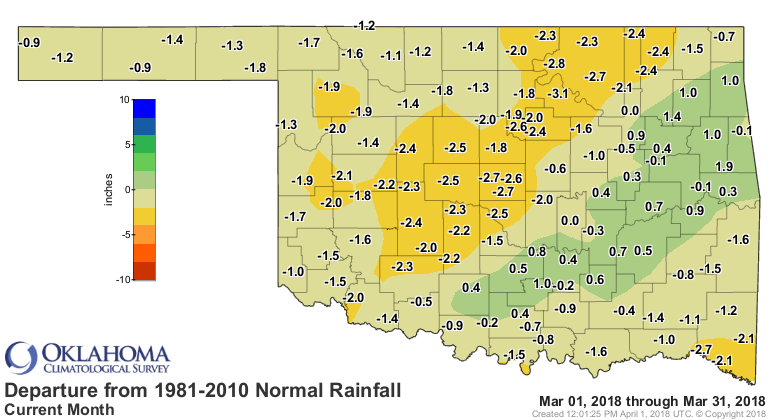
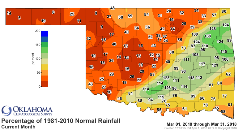
East central Oklahoma finished with its 34th wettest March on record at 0.42
inches above normal, while the Panhandle was 1.32 inches below normal to rank
as their 18th driest. The Mesonet site at Hooker recorded no precipitation for
the month, and 25 additional sites recorded a half-inch or less. Cookson led
the state with 5.97 inches. The first three months of the year were just a bit
below normal statewide, but the various regions across the state had remarkable
differences during that period. The Panhandle had its second driest January-
March on record with an average total of 0.32 inches, 2.38 inches below normal.
The southeast saw an average of 16.28 inches, 5.29 inches above normal, to rank
as their eighth wettest. The Mesonet sites at Eva and Hooker received 0.06
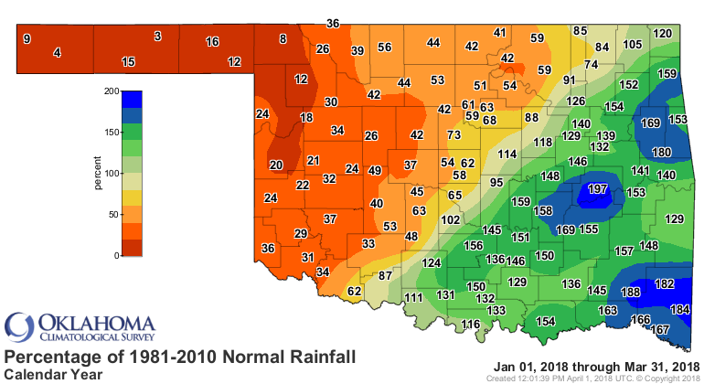
inches through that time. Broken Bow recorded 13.38 inches. Again, I-44 served
as a rough dividing line between areas with 10 inches or more to the southeast
and 3 inches or less to the northwest for the first three months of the year.
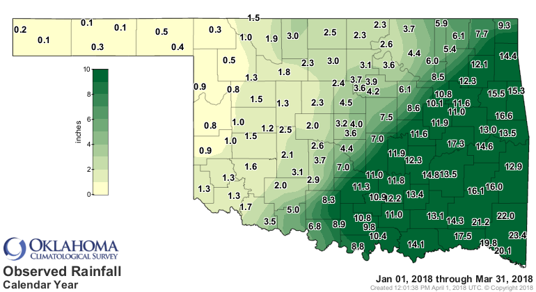
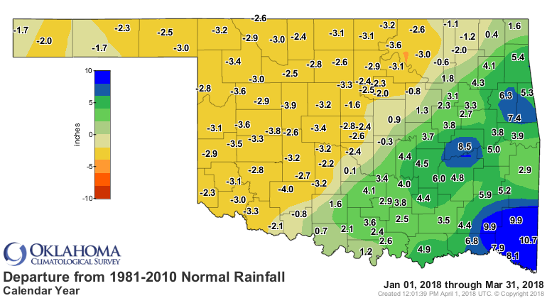
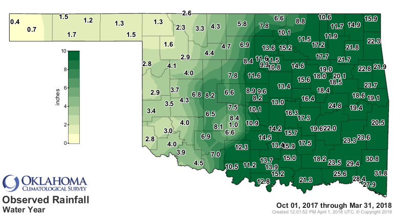
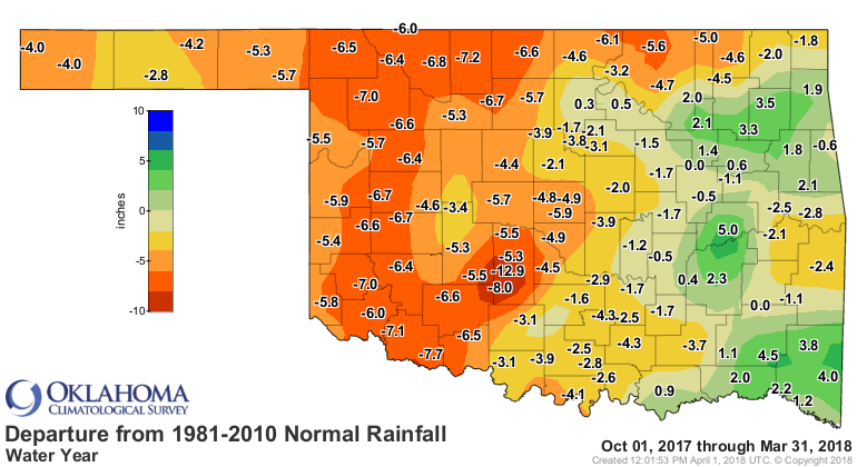
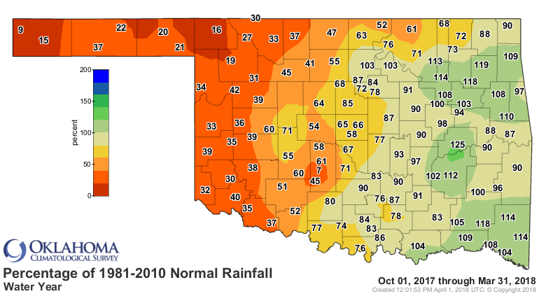
Dating back to Oct. 1, 2017, eight Mesonet sites in northwest Oklahoma had
recorded less than 2 inches of rain for that six-month period. Boise City and
Kenton received less than an inch.
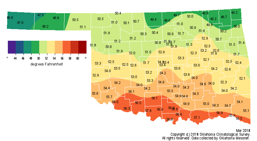
The month was 2.2 degrees above normal statewide with an average temperature
of 52.6 degrees, the 33rd warmest March on record. The Mesonet?s top
temperature reading of 95 was recorded at three different sites on the 23rd.
Kenton owned the lowest reading of 9 degrees on March 6. Freezing weather was
somewhat uncommon with the Mesonet site at Medicine Park spending just 1 hour
below freezing, while Eva spent 119 hours at 32 degrees or lower.

The first three months of the year were a tenth of a degree below normal with
a statewide average of 43.3 degrees.
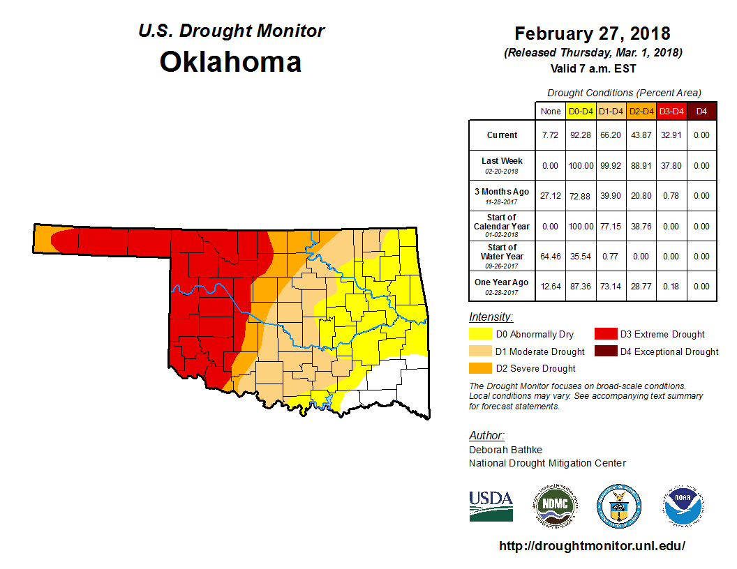
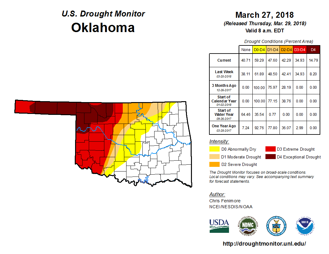
According to the U.S. Drought Monitor, most of the area southeast of I- 44 was
drought free by the end of March. Drought continued to intensify across the
northwestern half of the state, however. According to the U.S. Drought Monitor,
the total area of the state in drought decreased from 66 percent at the end of
February to 48 percent at the end of March. The most intense category of
drought ? the Drought Monitor?s intensity scale slides from moderate-severe-
extreme-exceptional, with exceptional being the worst classification ? increased
from zero percent at the end of February to 15 percent at the end of March.
That intensification occurred in the far northwest through much of the
Panhandle.
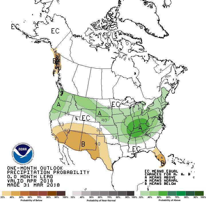
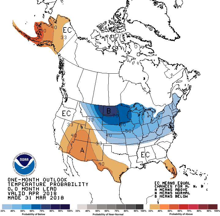
The April temperature and precipitation outlooks from the Climate Prediction
Center (CPC) did not bode well for drought improvement across western Oklahoma.
The precipitation outlook indicated increased odds of above normal
precipitation across far northeastern Oklahoma, but also below normal
precipitation across far western portions of the state. The picture for April
temperatures was unclear, so equal odds of above-, below- and near-normal were
expected.
That led to an April U.S. Monthly Drought Outlook that predicted drought as
persisting or intensifying across western Oklahoma. No drought development was
expected across eastern Oklahoma, however.

April 2 in Mesonet History
| Record | Value | Station | Year |
|---|---|---|---|
| Maximum Temperature | 92°F | BUFF | 2003 |
| Minimum Temperature | 21°F | EVAX | 2018 |
| Maximum Rainfall | 3.46 inches | TALI | 2013 |
Mesonet records begin in 1994.
Search by Date
If you're a bit off, don't worry, because just like horseshoes, “almost” counts on the Ticker website!