Ticker for February 15, 2018
MESONET TICKER ... MESONET TICKER ... MESONET TICKER ... MESONET TICKER ...
February 15, 2018 February 15, 2018 February 15, 2018 February 15, 2018
Help is on the way?
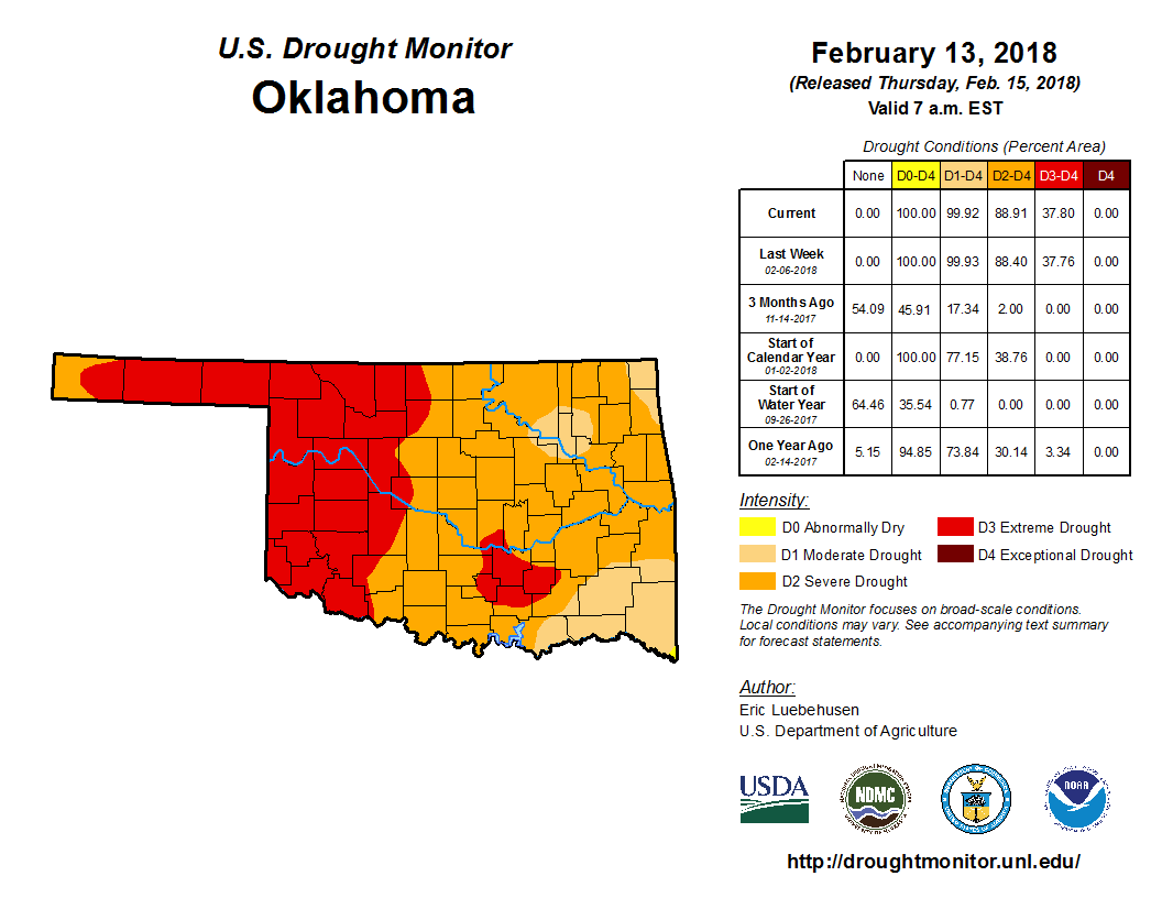
So no changes in the Drought Monitor map this week, which is both a good and bad
thing. Things didn't get gooder, but at least they didn't get badder (I have
an English minor, believe it or not).
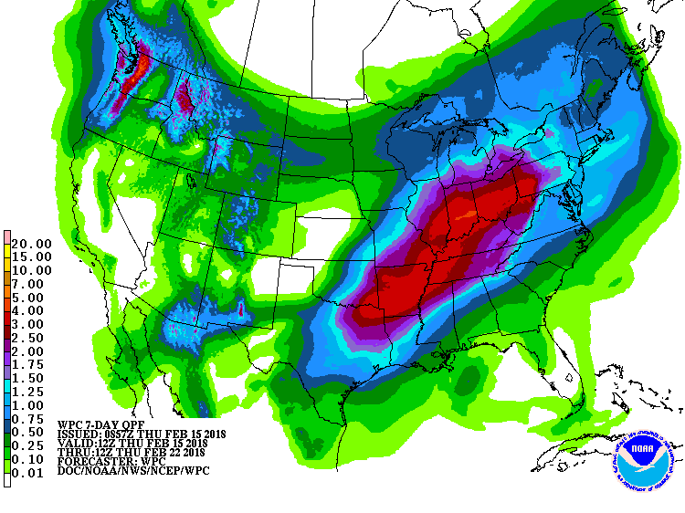
Anyway, here's your drought outlook for the near future, and *possibly* for the
next few months. Expect some really nice rains over the next week or so to
alleviate drought impacts for much of the area southeast of I44, a little bit of
relief just to the northwest of I44, and pretty much zilch to the northwest of
that. So the driest part of the state stays dry, while we see varying degrees
of relief as you travel southeast.
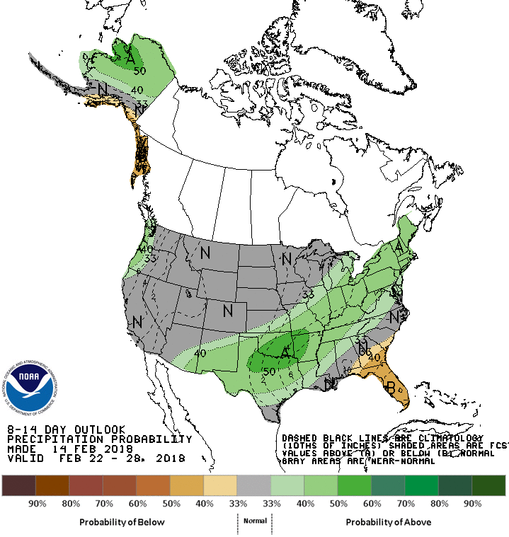
We will see more chances for a wet pattern late next week it would appear, but
again, more in the SE part of the state vs. the NW.
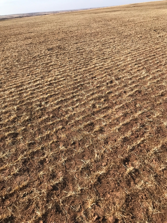
The drought is now entering dangerous territory too, as we start to slowly
morph into spring (it's Oklahoma...it could happen in a week for all we know).
We're soon to see the winter wheat crop start to take off and beg for REAL
moisture. For this field south of Butler, I'm afraid even the folks of
Grey's Anatomy might be too late.
The drought is still feeding off of dryness that started in early October. The
120-day rainfall maps remain bad since it hasn't rained much since we showed you
these last time.
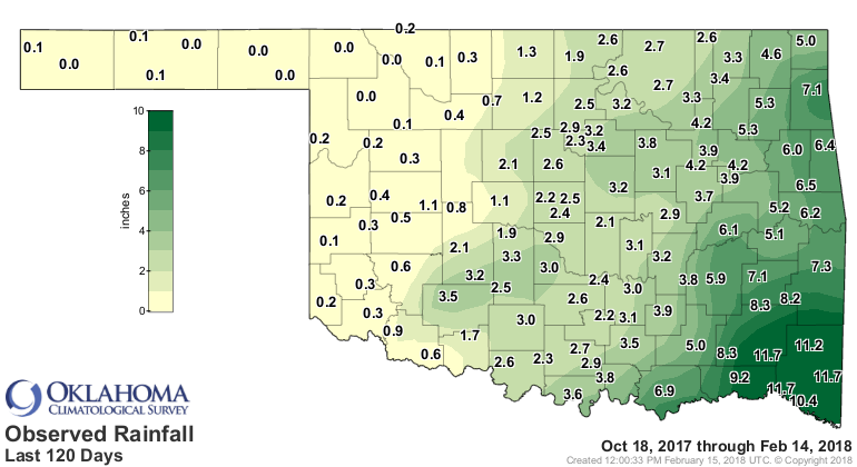
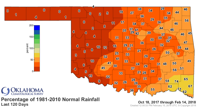
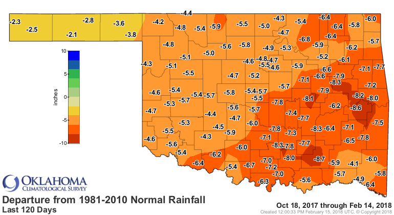
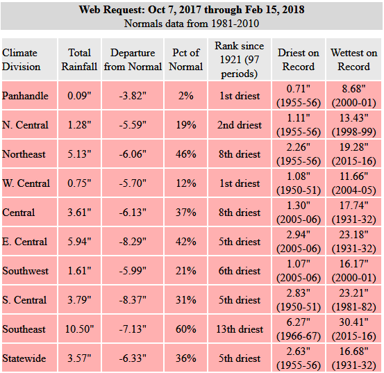
But lets go back to Oct. 7, probably the day it REALLY started to get dry as
Mother Nature turned off the spigot. You can see the data table here...the
statewide average of 3.57" is 6.33" below normal, the 5th driest such period
since at least 1921. And for the Panhandle and west central climate divisions,
the driest on record. No section of the state is doing much better than that.
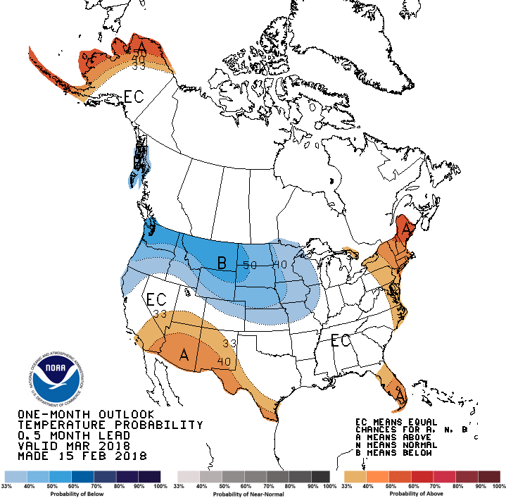
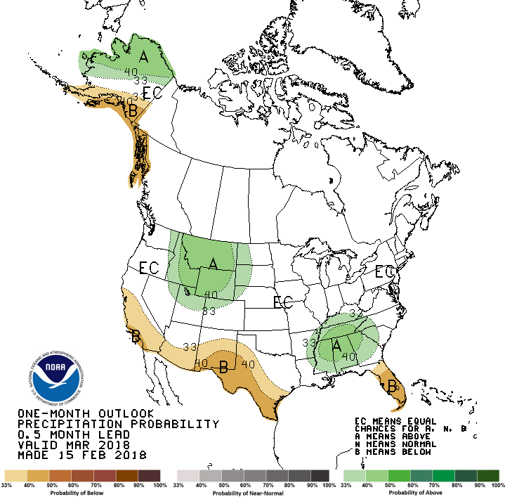
As for the upcoming March and March-May periods, again...good news and bad. For
March, well, no news is either good or bad. CPC gives us the dreaded "EC" for
equal chances across our area, meaning they feel we have equal odds for above-,
below-, or near-normal temperatures and precipitation. So not much signal there.
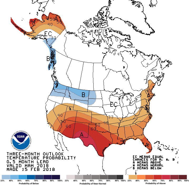
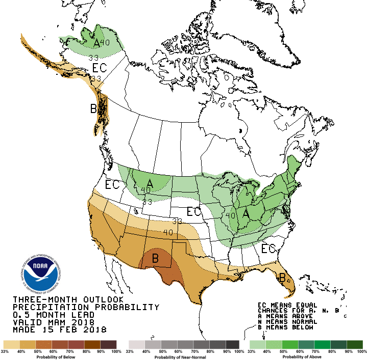
As we include April and May into the mix, key precipitation months for Oklahoma,
things get a bit more ominous. Now we see greatly increased odds for above
normal temperatures across much of the state (but increased at least a bit for
all), and increased odds for below normal precip across western Oklahoma once
again.
We're really going to have to hope that 3-month seasonal forecast doesn't come
to fruition or western Oklahoma is going to be in a world of hurt...more than
they are now. They'll be faced with below normal rains AND increased temperatures,
both prime drought intensifiers.
These outlooks are reflected in the seasonal drought outlook, which is valid
for today through the end of May. That wet signal we're seeing across the SE
half of the state over the next week or so should lead to some drought relief
and even removal, then climatology kicks in and keeps things tamped down across
that part of the state (i.e., our rainy season). Across western OK, however, we
see drought persisting or even intensifying.

So it's a good news/bad news situation. However, good rain fortunes across
the SE half of the state could very well shift or expand into the NW half as
well. So hope is alive!
Gary McManus
State Climatologist
Oklahoma Mesonet
Oklahoma Climatological Survey
(405) 325-2253
gmcmanus@mesonet.org
February 15 in Mesonet History
| Record | Value | Station | Year |
|---|---|---|---|
| Maximum Temperature | 86°F | BURN | 2000 |
| Minimum Temperature | -22°F | KENT | 2021 |
| Maximum Rainfall | 2.12″ | CLOU | 2001 |
Mesonet records begin in 1994.
Search by Date
If you're a bit off, don't worry, because just like horseshoes, “almost” counts on the Ticker website!