Ticker for August 15, 2017
MESONET TICKER ... MESONET TICKER ... MESONET TICKER ... MESONET TICKER ...
August 15, 2017 August 15, 2017 August 15, 2017 August 15, 2017
Summer Shmummer
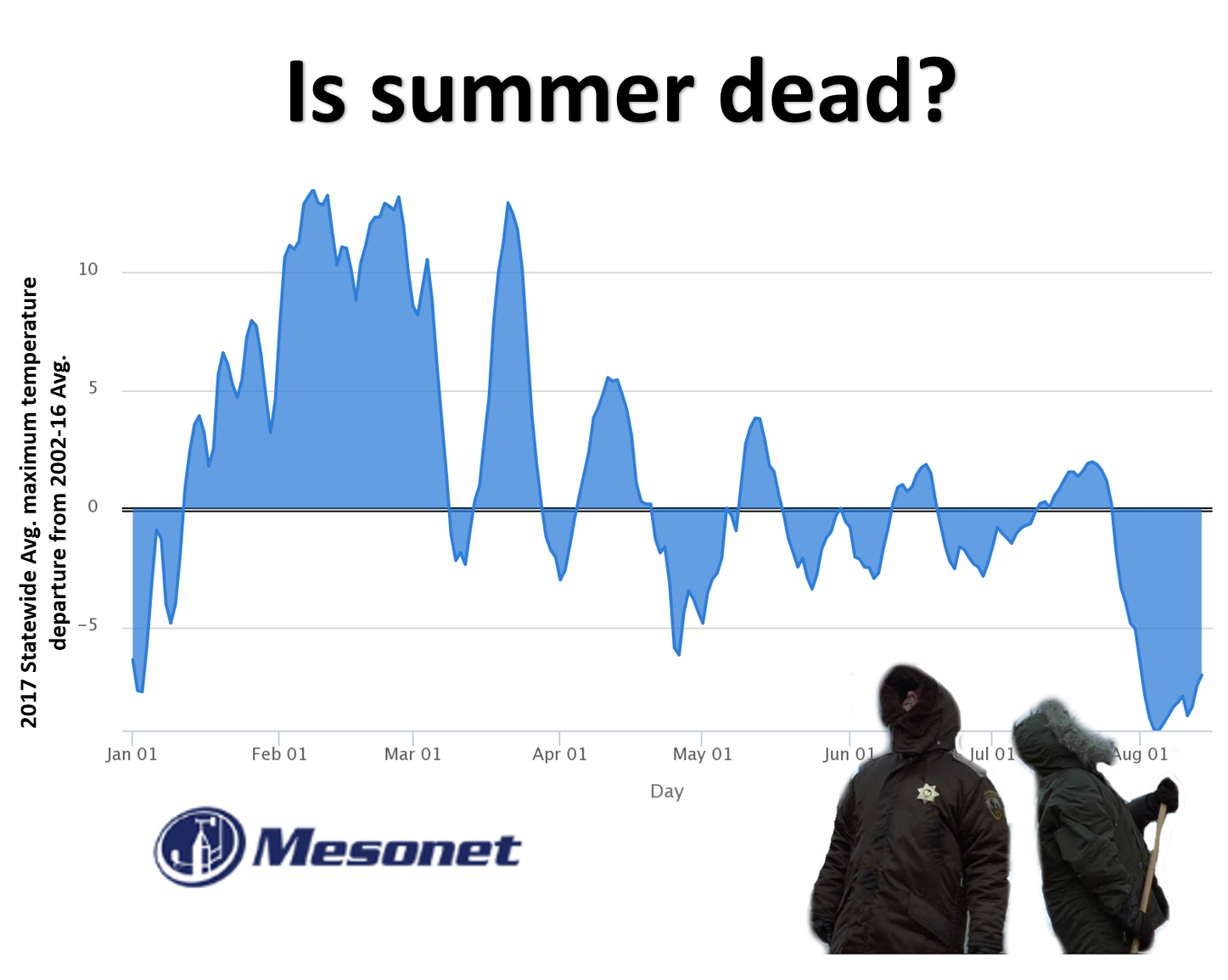
We know that August 2017 has been unusually wet (statewide average of 4.55 inches
through today, already the 17th wettest on record with more rain on the way), but
I'm sure we're all well aware that it's been unusually mild as well. How mild?
Well, according to preliminary data from the Oklahoma Mesonet, we're on our way
to having one of our coolest Augusts on record as well. Here are the statewide
average max, min and mean temps for August 2017, through yesterday.
-***-
Aug. 1-14 Avg. Tmax Avg. Tmin Avg. Tavg
Mesonet Obs 85.8F 67.1F 76.4F
1981-2010 Normal 94.2F 69.5F 81.9F
Departure -8.4F -2.4F -5.5F
-****-
Now that makes a lot of sense when it comes to the average high temps being more
anomalous than the low temps. Summer heat is generally tempered (pardon the pun)
by rainfall and the associated cloudiness...somewhat by soil moisture as well,
but rain and clouds are the biggies. So lots of rain mean those high temps are
quashed, but it's not like we're getting arctic cold fronts, so low temps are
not as impacted as much. Remember, moisture and clouds can prevent radiative
cooling at night, AND as you reach the dew point and dew forms, energy is
released.
But, that's a physics lesson for another time. And if I have it wrong, I'm sure
somebody will give me a physics lesson before I give you a physics lesson. Now
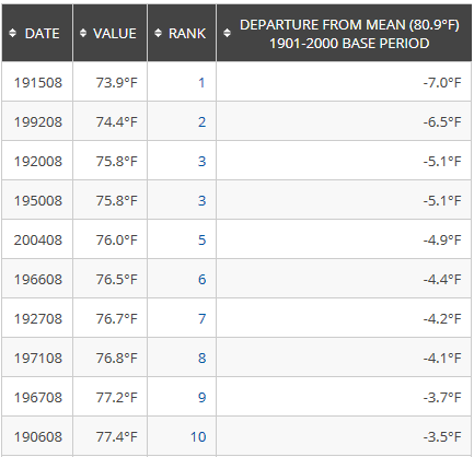
check this out. Remember how 1915 was Oklahoma's wettest August on record with
a statewide average of 6.48 inches? Well, it's also the state's COOLEST August
with a statewide average of 73.9 degrees.
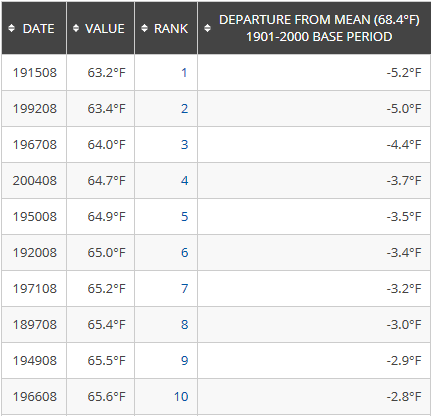
AHA! So my theory holds water (no pardoning that pun). Anyways, right now, August
2017 would rank as the sixth coolest August on record (dating to 1895) according
to the average (high temps + low temps divided by 2) and the third coolest
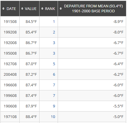
according to statewide average maximum temperatures (1915 is coolest in that
category as well at 84.5 degrees). Nothing special on the low temperature side.
I'll give you those three top-10 lists for average, max and min temperatures.
2017 isn't in those lists yet, obviously, since it isn't over yet.
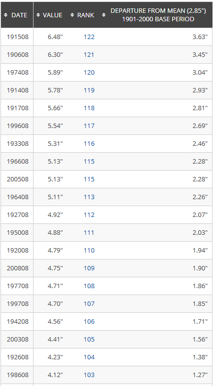
And here is the list of top-20 wettest Augusts for comparison. You'll see a lot
of those cool max-temp Augusts in the top-20 wettest as well, per my previous
rain vs. heat during the summer point.
Now this isn't foolproof, of course (which is what allowed me to write it...if
it was foolproof, I'd be in trouble). Imagine you're cruising along with a
typical hot August and a tropical storm remnant pops up, blasting your statewide
average precip total upwards? Singular or even a few singular events can cause
the month to fall outside the correlation.
So we're gunning for records, and only the types of records a climatologist
can get excited about. We have more rain on the way over the next few days,
so our wettest-August rankings will improve
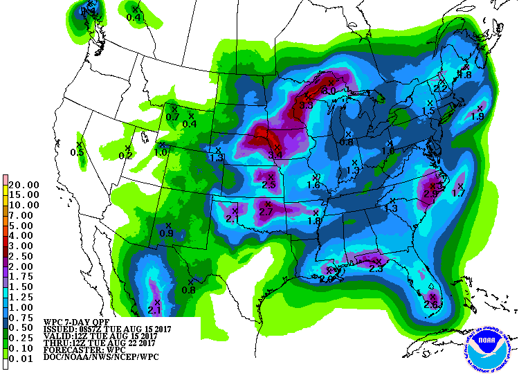
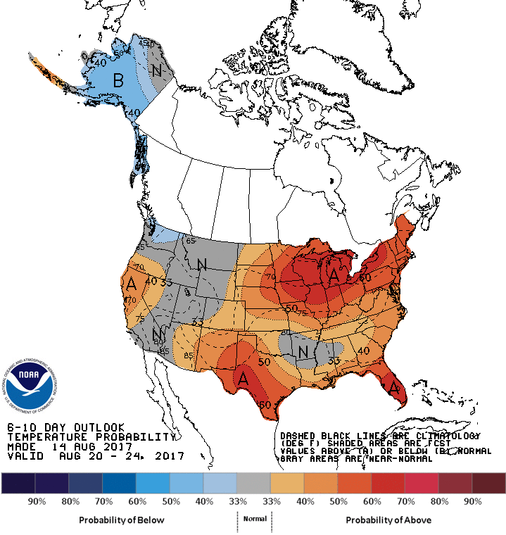
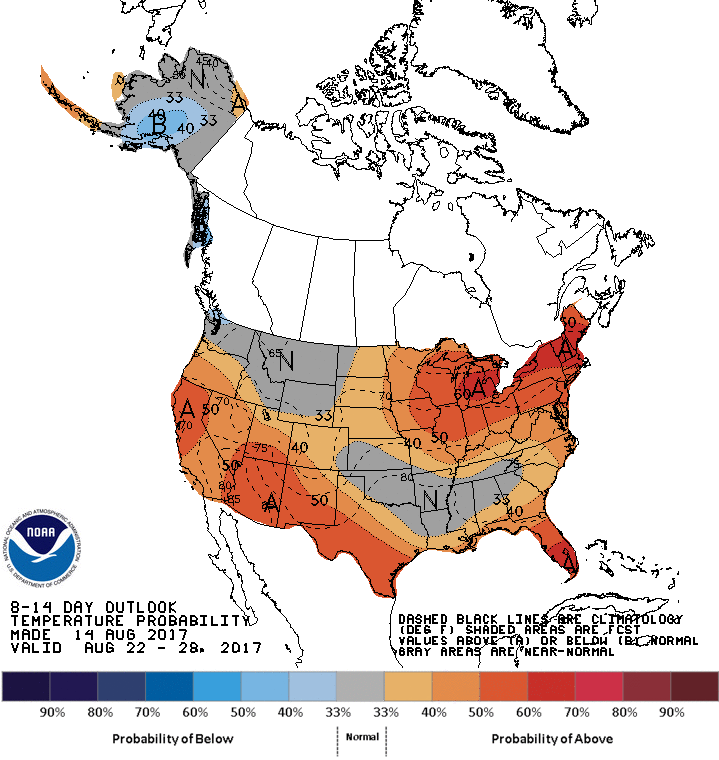
while temperatures are going to head back to more August-like territory.
We may not set any records, but it's been (mostly) fun so far, right?
Gary McManus
State Climatologist
Oklahoma Mesonet
Oklahoma Climatological Survey
(405) 325-2253
gmcmanus@mesonet.org
August 15 in Mesonet History
| Record | Value | Station | Year |
|---|---|---|---|
| Maximum Temperature | 107°F | GRA2 | 2024 |
| Minimum Temperature | 50°F | EVAX | 2016 |
| Maximum Rainfall | 4.96″ | WIST | 2018 |
Mesonet records begin in 1994.
Search by Date
If you're a bit off, don't worry, because just like horseshoes, “almost” counts on the Ticker website!