Ticker for August 1, 2017
MESONET TICKER ... MESONET TICKER ... MESONET TICKER ... MESONET TICKER ...
August 1, 2017 August 1, 2017 August 1, 2017 August 1, 2017
Augtember?
Oh, it rained on the last day of the month again, messing up my carefully
calculated end-of-the-month summary data? SHOCKER! So while you read my July
monthly summary below, enjoy your rain-soaked Tuesday
with the fall-like temperatures

and prospects for even more of the same down the road.
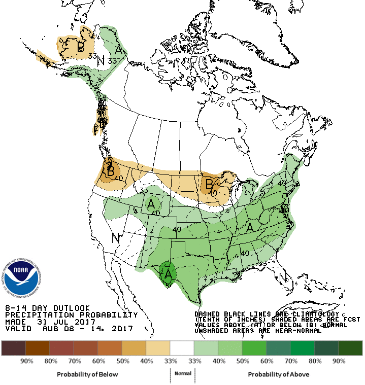
Pay special attention to the August outlooks from CPC. Could we skip August, the
worst month (next to November, December, January, and February) in the Oklahoma
weather calendar, and go right to September?? Augtember? Sepgust?
But remember, as we hearken back to the days of yore (okay, a week ago) when it
was hot and dry, and we didn't like it.
And now, for your edification, the July summary.
--------------------------------------------------------------------------------
July Follows Summer Script
Aug. 1, 2017
July followed Mother Nature?s customary script for mid-summer in Oklahoma,
complete with long stretches of sun and scorching temperatures, wildly varying
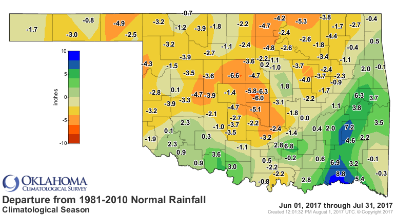
rainfall, and rapidly intensifying drought conditions. Rainfall fortunes were
separated roughly between the haves to the southeast of I-44 and the have-nots
to the northwest. Parts of the southeast saw more than 10 inches of rain, while
less than an inch fell from central though west central Oklahoma.

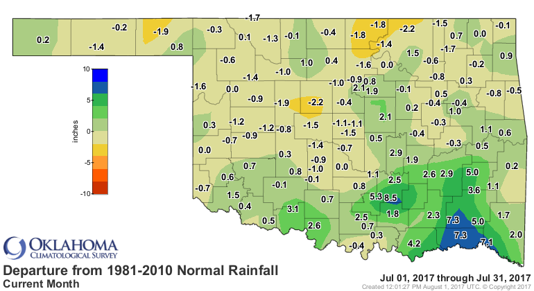
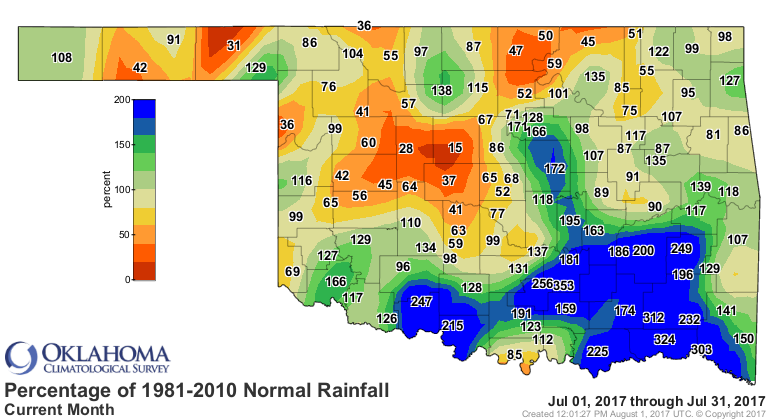
The precipitation extremes exemplified the moisture disparity within the state.
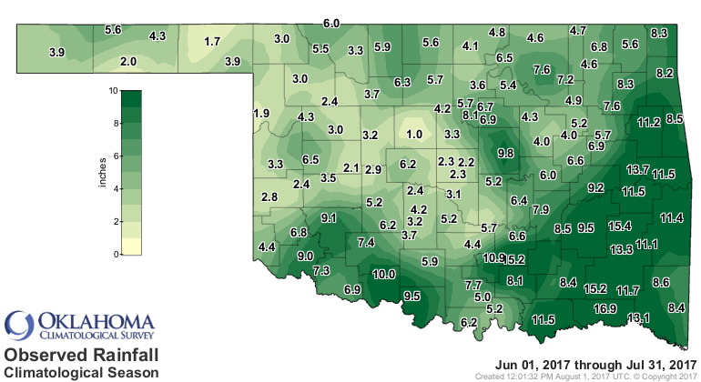
Fittstown led the Mesonet?s 121 sites with a whopping 11.8 inches of rain, and
three other southeastern sites ? Antlers, Valliant and Hugo ? recorded at least
10 inches. Even the far western Panhandle got into the act with Kenton receiving
over 7 inches, more than a third of their annual average of 18.03 inches.
Meanwhile, Kingfisher recorded the lowest July total at 0.39 inches and nine
other central and west central Oklahoma sites reported less than an inch.
Thanks to the hefty totals in the southeast, the statewide average came in
about half an inch above normal at 3.41 inches, the 43rd wettest July since
records began in 1895. Southeastern Oklahoma?s average total of 7.69 inches was
over 4 inches above normal and the eighth wettest July for that region. In
contrast, west central Oklahoma experienced their 37th driest July at nearly an
inch below normal. The first two months of climatological summer, June through
July, averaged 5.5 inches statewide, nearly 2 inches below normal and the 39th
driest such period on record.
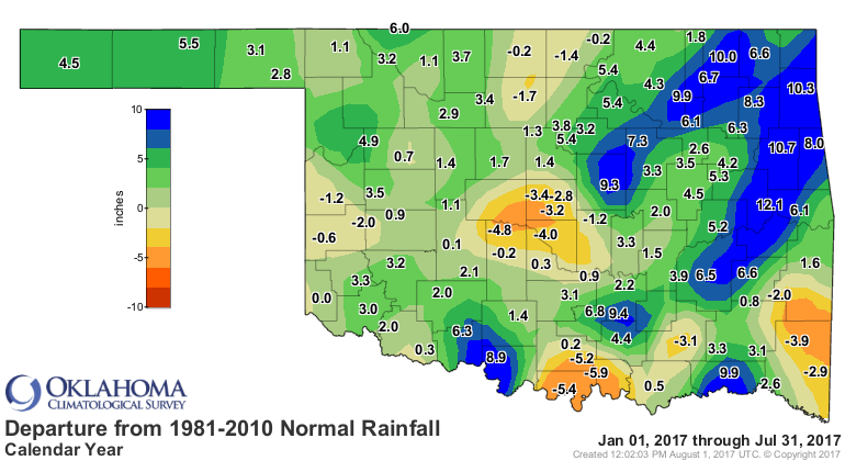
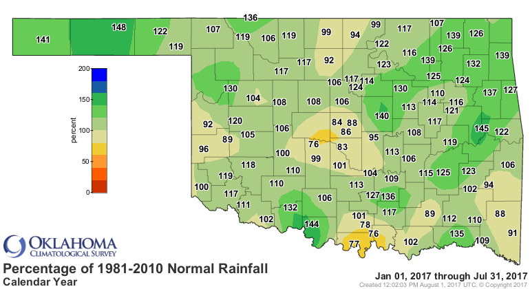
The January-July average was 23.47 inches, 1.52 inches above normal and the
34th wettest such period on record.

The Mesonet site at Hooker set the standard for triple-digit temperatures
during July, reaching that mark 16 times. Hooker also led all Mesonet sites for
the year through July with 25 readings at or above 100 degrees.

Kingfisher scored the highest July temperature with 108 degrees on the 22nd.
The Oklahoma Mesonet recorded at least one triple-digit temperature on 22 of
July?s 31 days. Throw humidity into the mix and the oppressive heat reached
dangerous levels. The Mesonet calculated a heat index of at least 110 degrees
82 times at its 121 sites, with Copan reaching a punishing 115 degrees on July
22. Only at month?s end did Mother Nature give the state a reprieve. A cool
front and northwesterly flow aloft provided relatively pleasant weather
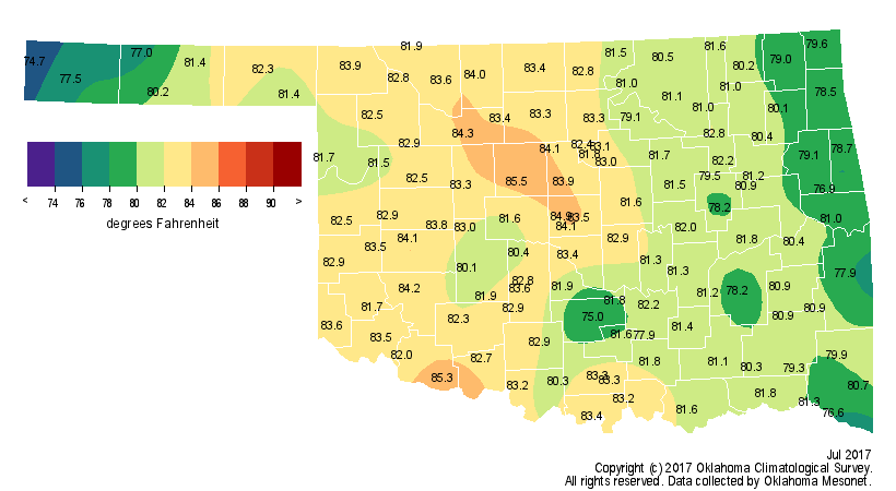
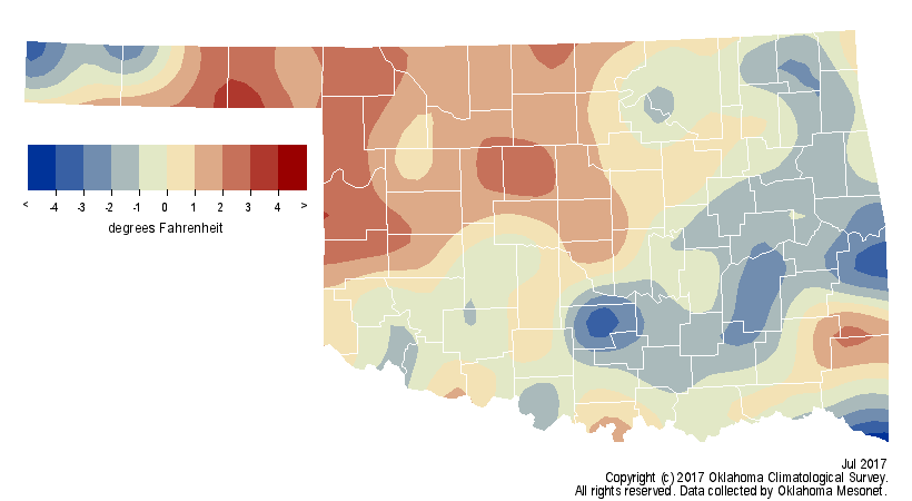
statewide with highs in the 80s and low 90s. The month finished right at normal
with a statewide average of 81.5 degrees, although it was cooler than normal in
the southeast and warmer in the northwest, owed largely to the rainfall
disparity.
The year was still on pace to finish as one of the warmest on record for the
state with a January-July average of 62.1 degrees, 2.6 degrees above normal for
that period and the fifth warmest on record.
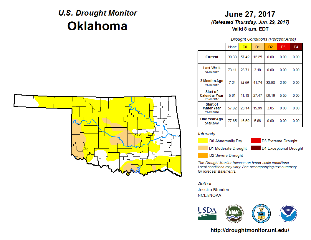
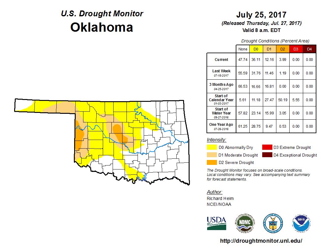
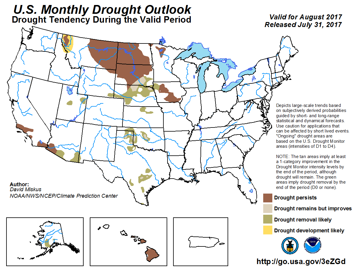
The flash drought that erupted in June continued to intensify during July. At
the end of June, 12 percent of the state was considered in moderate drought
with another 57 percent considered abnormally dry, per the U.S Drought Monitor.
The last report in July had 12 percent of the state again in moderate drought,
but another 4 percent intensifying to severe drought. The Drought Monitor?s
intensity scale slides from moderate-severe-extreme-exceptional, with
exceptional being the worst classification.
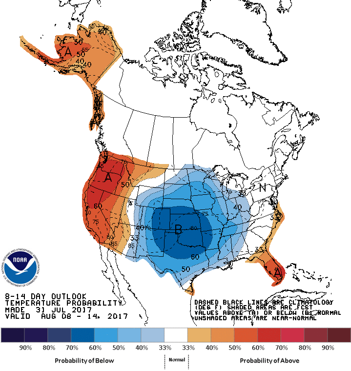
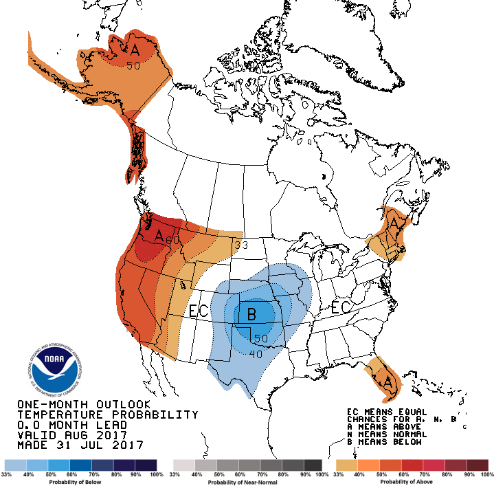
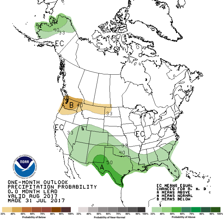
While August often brings the worst that Oklahoma summers have to offer, the
latest outlooks from the Climate Prediction Center give hope for milder and
wetter weather to end summer. The August temperature and precipitation outlooks
see increased odds of below normal temperatures and above normal precipitation
across the entire state. CPC?s monthly drought outlook calls for improvement
and possible removal of drought by the end of August.
Gary McManus
State Climatologist
Oklahoma Mesonet
Oklahoma Climatological Survey
(405) 325-2253
gmcmanus@mesonet.org
August 1 in Mesonet History
| Record | Value | Station | Year |
|---|---|---|---|
| Maximum Temperature | 115°F | KIN2 | 2012 |
| Minimum Temperature | 53°F | KENT | 2018 |
| Maximum Rainfall | 5.04 inches | NOWA | 1995 |
Mesonet records begin in 1994.
Search by Date
If you're a bit off, don't worry, because just like horseshoes, “almost” counts on the Ticker website!