Ticker for March 8, 2017
MESONET TICKER ... MESONET TICKER ... MESONET TICKER ... MESONET TICKER ...
March 8, 2017 March 8, 2017 March 8, 2017 March 8, 2017
NW OK under siege
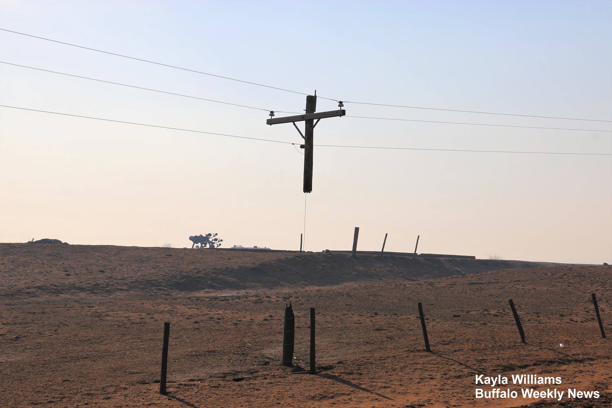
We often marvel at weather hazards, amazed at their beauty and fury. When it hits
close to home, however, it takes on special meaning. It's a good reminder we
should always keep in mind the folks that are being impacted during such calamities
as the fires up in Beaver, Harper and Woodward counties. And my beloved hometown
of Buffalo (have I mentioned I'm from Buffalo before??) is ground central in
this devastating disaster.
According to information provided by the Oklahoma Forestry Services, the three fires
(code named "Starbuck," "283" and "Selman") have now burned 833,941 acres. That's
an area the size of Enid, OKC and Tulsa combined. And those fires are 0% contained.
That's right...0%.
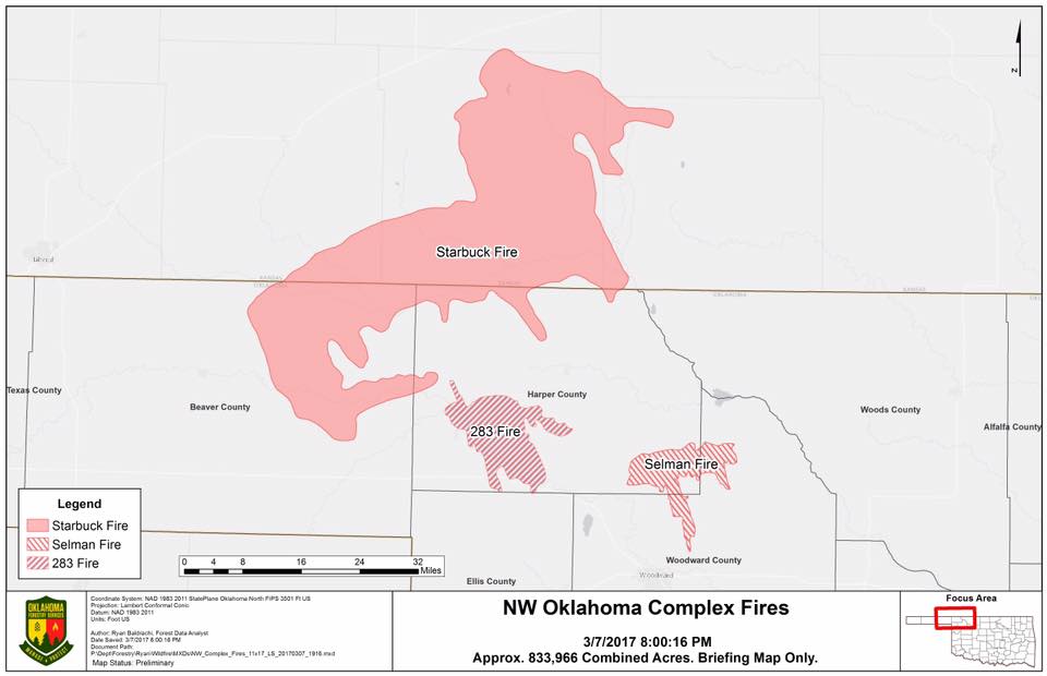
And that's just those fires that started in OK (the Starbuck fire traveled into
KS, than came back south with the post-front windshift).
Some may wonder how those fires are able to get so far out of control, without
a bit of containment for 2 days now. Well, contrary to popular belief, Oklahoma
is not the flat pancake of a land it's often made out to be. Yes, you can see
for miles and miles in the Panhandle, which is one of its draws to some
like myself. But those areas in NW OK are covered in red-dirt canyons, hills, and
sandy inaccessible fields. One of the most beautiful sights in the world, at
least according to this NW OK boy, is a drive at sunset through the red
canyons that surround Buffalo. The orange-red light of sunset combines with
those red canyons to set the world ablaze (and certainly no pun intended).
What's fueling these fires? Nobody should be surprised about these fires, except
for maybe their extent. They are made extreme by relative humidity in the
single digits, winds gusting to over 50 mph and the dead/dormant grass of March
(aided by drought conditions). According to data provided by OSU Fire
Meteorologist and Mesonet OK-FIRE Manager J.D. Carlson, March is indeed the top
month for fires in OK, both in number and acreage burned.
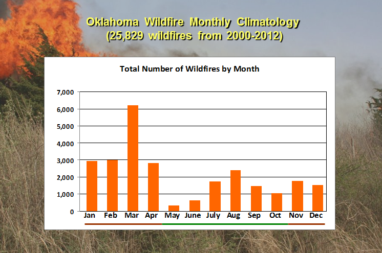
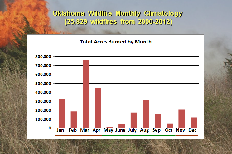
You can see the progression of the fire season as vegetation undergoes a
transformation in the winter to a dead/dormant state, reaching a climax in
March. At that point, the jet stream starts to bring more powerful storm
systems across the region without the moisture return from the Gulf seen later
in the spring. We also start to warm up in March, another factor in wildfires
both due to the heat and also lower humidity. Then we start to see a downward
trend later into spring as things start to green up, then a slide back to fire
danger in the summer as things get hot and dry again. However, if drought is in
place and you get less of that green vegetation in the early spring, the fire
season can extend right on into summer.
Okay, enough of that rambling explanation. Today, we will have conditions
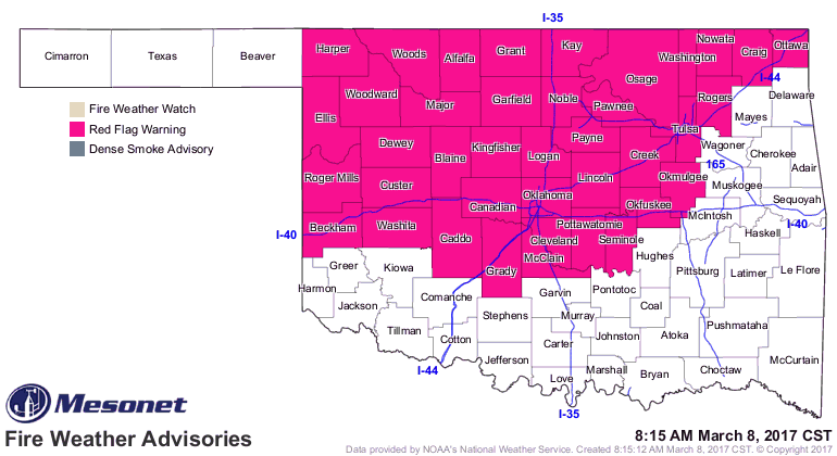
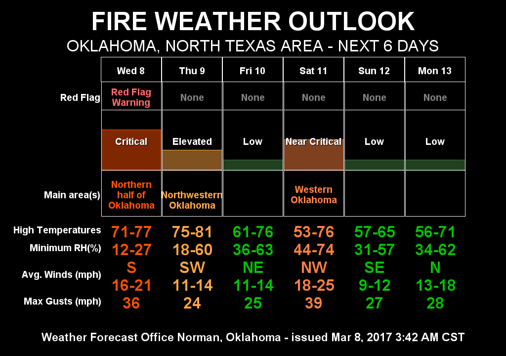
conducive to keeping those fires alive, but also starting new fires. A Red Flag
Fire Warning is in place across much of the NW corner of the state, extending
into central and NE OK.
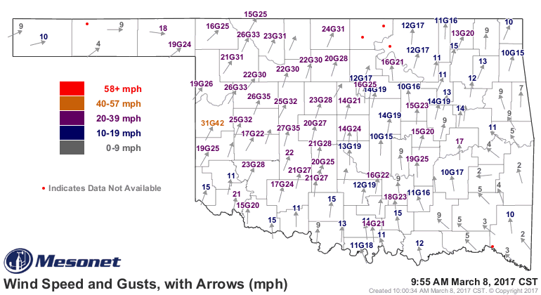
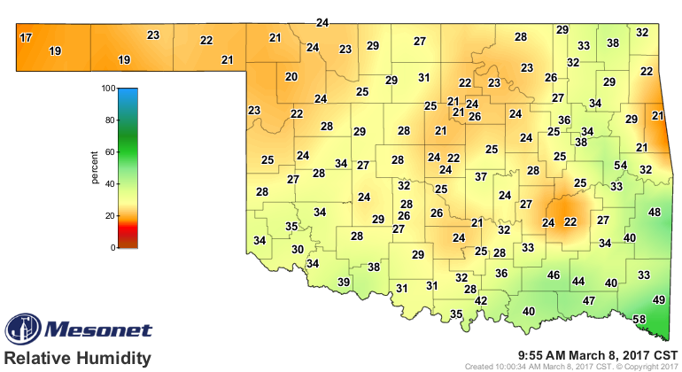
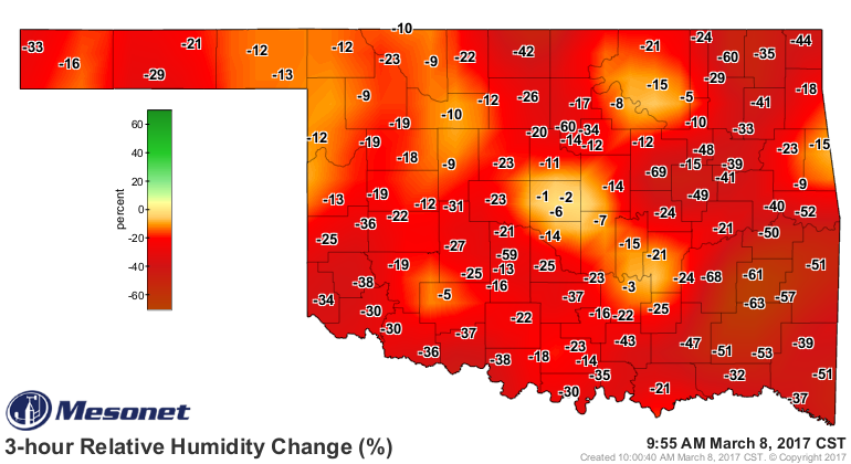
Winds are already howling from the southwest at 25-35, gusting to 45 mph, the
relative humidity is down into the 20s already and dropping fast as it get into
the warmth of the day.
While today is the critical day, there will be elevated fire danger continuing
in the state off an on for the next several days.
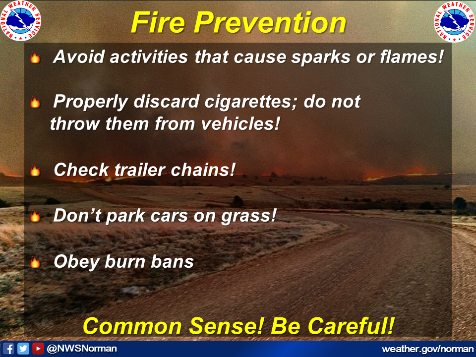
Today is not the day to make sparks! Here are some fire prevention tips that
can save lives and property.
Gary McManus
State Climatologist
Oklahoma Mesonet
Oklahoma Climatological Survey
(405) 325-2253
gmcmanus@mesonet.org
March 8 in Mesonet History
| Record | Value | Station | Year |
|---|---|---|---|
| Maximum Temperature | 84°F | HOLL | 2002 |
| Minimum Temperature | 7°F | SEIL | 2008 |
| Maximum Rainfall | 3.01″ | BESS | 2016 |
Mesonet records begin in 1994.
Search by Date
If you're a bit off, don't worry, because just like horseshoes, “almost” counts on the Ticker website!