Ticker for March 9, 2017
MESONET TICKER ... MESONET TICKER ... MESONET TICKER ... MESONET TICKER ...
March 9, 2017 March 9, 2017 March 9, 2017 March 9, 2017
Drought erupts in fury
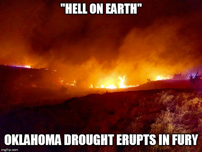
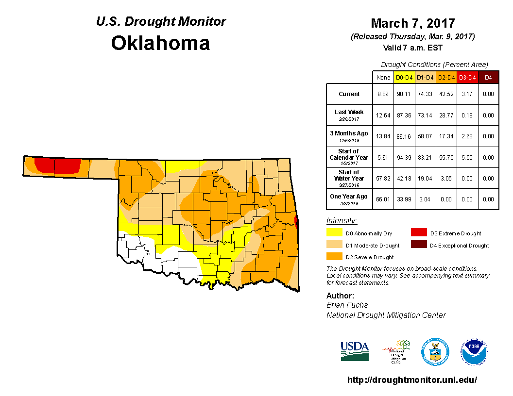
Like the blazing fires covering NW OK, the newest U.S. Drought Monitor map
erupted with unwanted colors as severe drought increased from 29% of the state
to 39%, and extreme drought jumped to over 3%. Most of that increase came across
that area of fires in NW OK, a startling reminder of drought's propensity to
show you its severity well after impacts have started to creep along.
I'll take one on the chin here...I had suspected a worse drought situation up that
way but had been talked out of asking for an increase in intensity for a couple
of weeks. It's just another reminder to listen to people on the ground. The clues
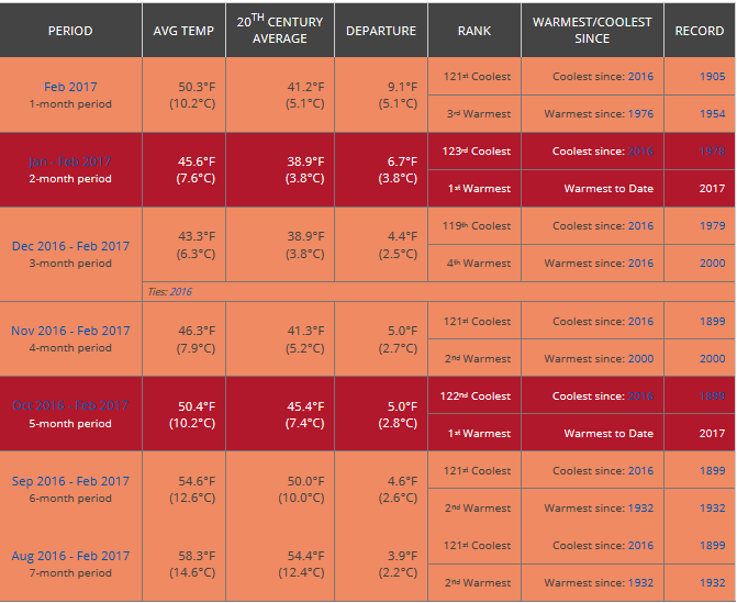
were there...the warmest January-February and October-February periods on record,
long periods between good rains, extended periods of extreme fire danger, etc.
Think back, how many Red Flag Fire Warning days do you remember? While there
were never any big fires like we saw this week, each one of those days helped
lead up to this catastrophic event...drying out/curing the fuel needed for the
fires, keeping the wheat from greening up (a key tool used by firefighters to
steer fire towards to help extinguish it), desiccating the soils, drying out
Mother Nature's roman candles -- the Eastern Red Cedar.
Another lesson learned in Oklahoma Drought Monitoring...you can sit hundreds of
miles away looking at data, but those of us from the semi-arid areas of far
western Oklahoma and the rest of the folks up and down the High Plains know that
moisture that falls from the sky can disappear twice as fast with a week of wind
and warm weather, and in this case, we're talking more than 6 months worth of
unusual heat, wind and sporadic moisture.
Let's take a look at those rainfall maps and you'll see what I'm talking about.
In the short term, we see that NW OK has gone a LONG time without appreciable
moisture, much less than what is needed to make up for all that warm and
sometimes downright hot weather.
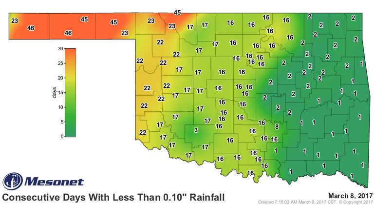
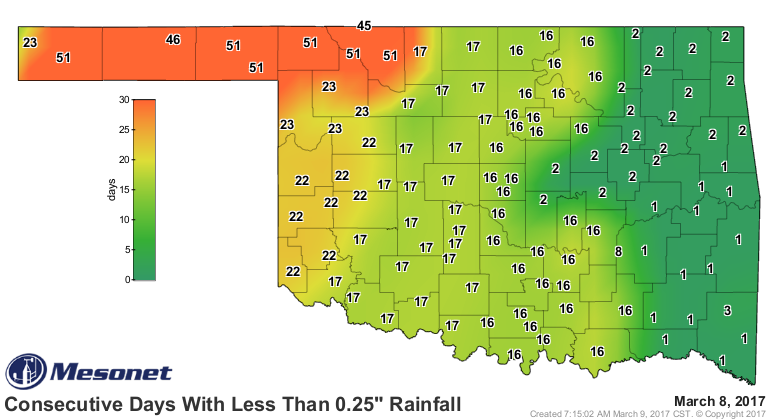
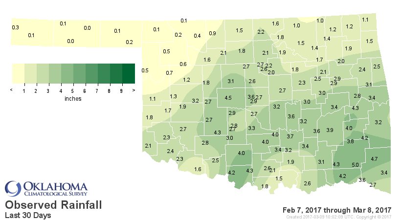
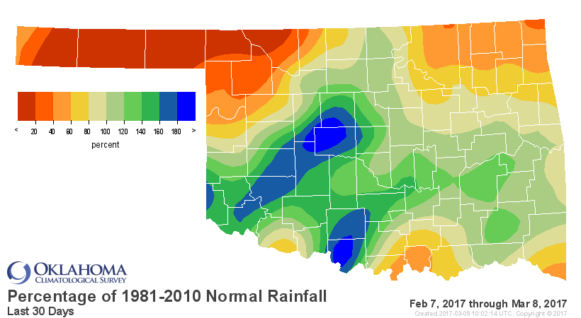
So yes, the early period has been dry across much of northern OK, but especially
in that NW OK region. But this dry weather started well before that, way back in
early September. Take a look at these maps from Sept. 2 through today. Lots of
nasty reds and oranges (sorry OU and OSU fans).
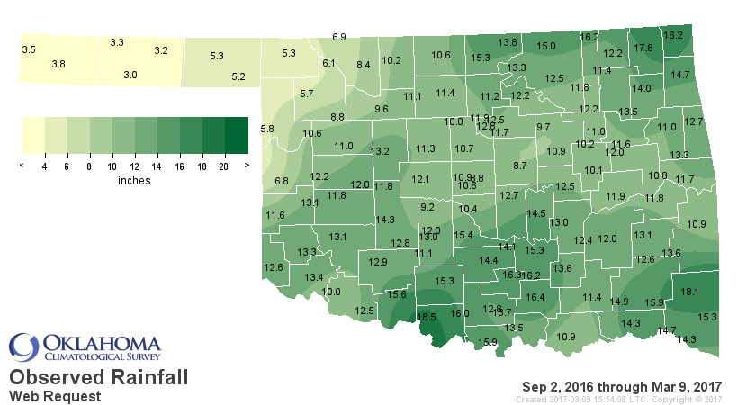
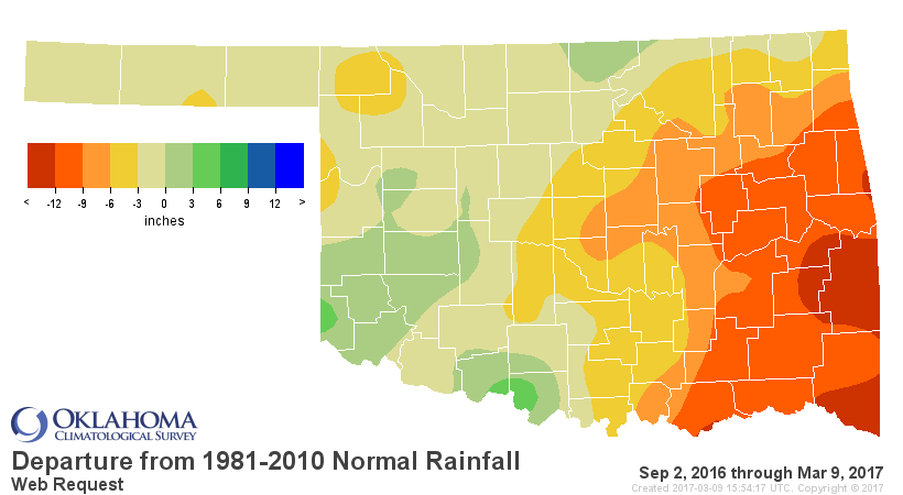
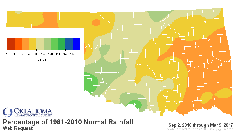
If anything, those longer term maps show just how dry SE and EC OK has been. But
even the stats across NW OK are quite deceiving. Look at Buffalo's total of
5.3 inches. Three inches of that fell in one or two days in mid-January during
the ice storm. The rest of that 6+ month period they had less than 2 inches.
Again, that's a key. The longer you go between rains, the more deceptive the
statistics get.
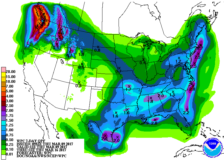
How about future prospects? Well, we do see increasing chances of rain for the
weekend, and also a return to more seasonal temps. And then more chances of
rain for next week. It doesn't amount to a drought buster at this time, but
hopefully a fire-danger dampener.
Sunday's lows will give us a possible final glance at winter.
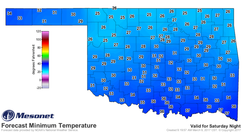
To tell you the truth, that's really not what we need right now. We need it to
stay warm and get some good rains to speed up the greening process. Those low
temps will just help keep things dormant longer. But, temperatures do appear
to be back on the uptick later next week.
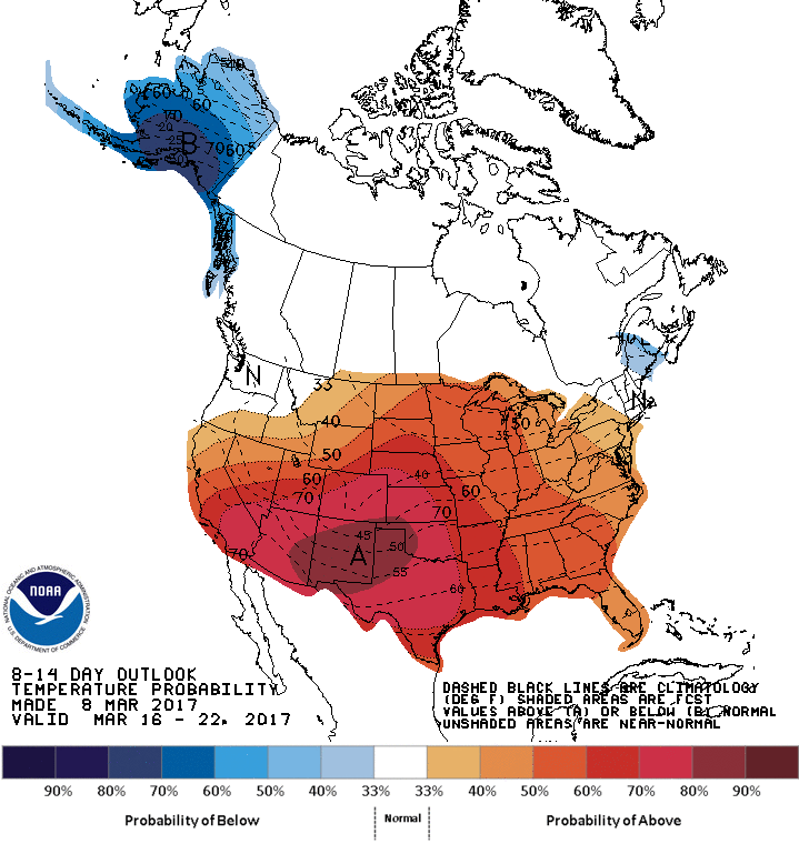
If it doesn't rain, however, and we get back to the unusual warmth...when it
doesn't rain, fire will pour.
Gary McManus
State Climatologist
Oklahoma Mesonet
Oklahoma Climatological Survey
(405) 325-2253
gmcmanus@mesonet.org
March 9 in Mesonet History
| Record | Value | Station | Year |
|---|---|---|---|
| Maximum Temperature | 87°F | CAMA | 2017 |
| Minimum Temperature | 9°F | EVAX | 2022 |
| Maximum Rainfall | 3.32″ | CLOU | 2023 |
Mesonet records begin in 1994.
Search by Date
If you're a bit off, don't worry, because just like horseshoes, “almost” counts on the Ticker website!