Ticker for January 12, 2017
MESONET TICKER ... MESONET TICKER ... MESONET TICKER ... MESONET TICKER ...
January 12, 2017 January 12, 2017 January 12, 2017 January 12, 2017
Go ahead and buy ice cream
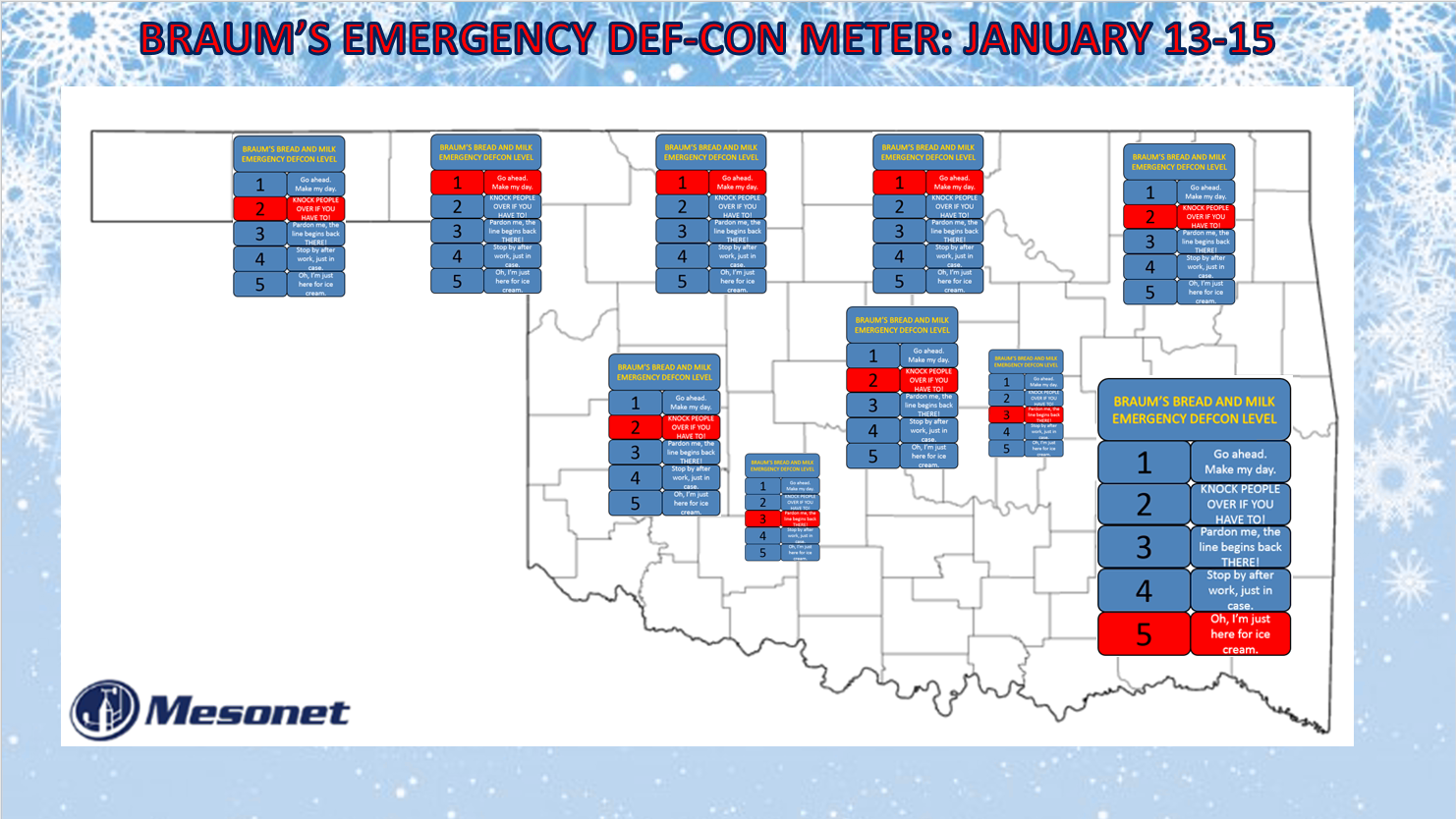
I mean, why not, right? When you lose power, all you'll have to do is stick it
outside (or even better, eat it!). Although eating ice cream in arctic air
without power might not be a good idea either. Hmmmmm.
Okay, now that I have the scare tactics out of the way, the BRAUM'S BREAD AND MILK
EMERGENCY DEF-CON map shows about what I know. And it ain't any different from
yesterday, or the day before. Once again, to lay it out in not-so-scientific
terms...the NW part of the state is going to get hammered by ice (probably),
the I-44 corridor will be sort of a transition point where the freezing line
could waver back and forth creating significant ice accumulations or just get
occasional cold rain and occasional freezing rain leading to who knows what, and
southeast and south central Oklahoma is going to get a cold rain, and lots of it.
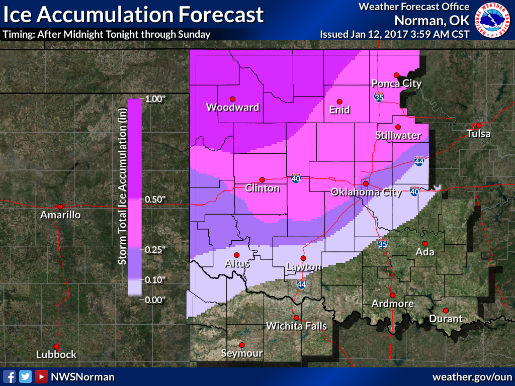
As for timing, it looks like it will start late tonight from the SE as that warm,
moist air travels above the shallow layer of cold air and the farther north the
precip gets, the more chance it has to both lower the temperature through
evaporative cooling AND fall as either freezing drizzle or freezing rain. That's
where that wet-bulb temperature and freezing-line map from the Oklahoma Mesonet
will continue to be so important. I still feel that for much of the state's
population (i.e., along the I-44 corridor including the OKC and Tulsa metro
areas), this will continue to be more of an hour-to-hour event than a "forecast
a day or two out) for exact impacts. That means staying tuned in to not only
your local NWS and media folks, but also keep that air temperature map from
the Mesonet handy.
http://www.mesonet.org/index.php/weather/map/air_temperature
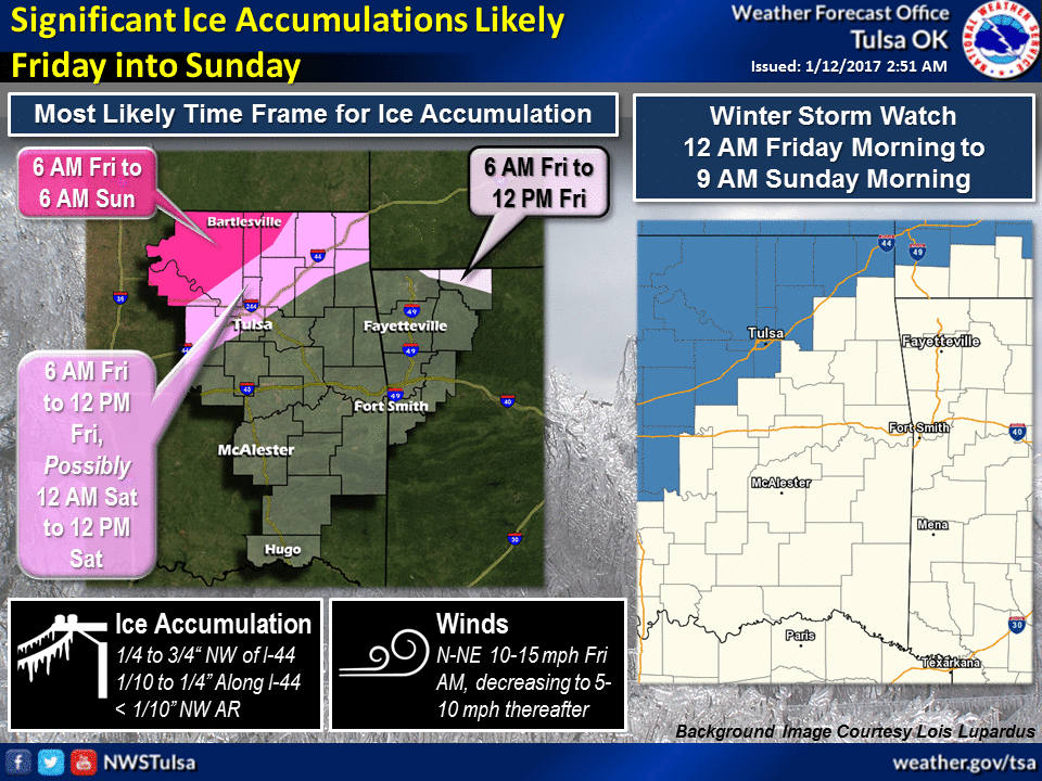
Back to the timing, late tonight, increasing as we go through the day tomorrow,
then the freezing line should succumb to the push from the warm air to the south
a bit and it moves farther NW through the event. So the farther NW you live in
the state, the longer your impacts from ice will occur. Here's more from the
NWS.
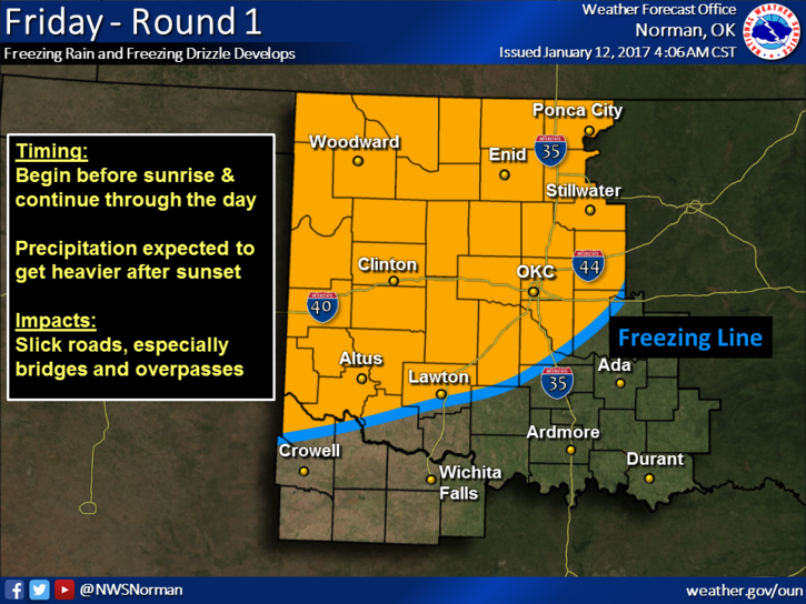
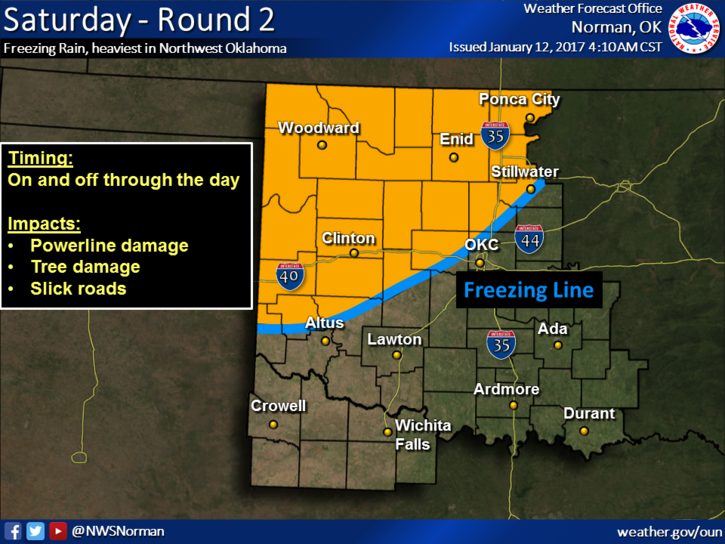
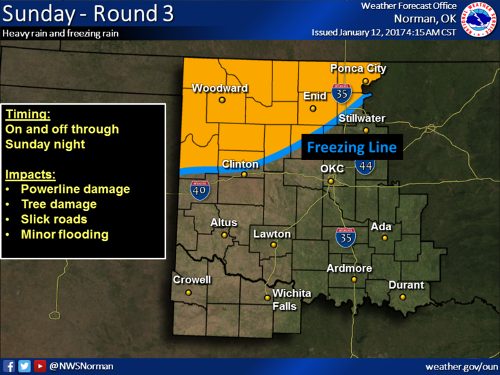
And those impacts should be obvious, since we saw several of these types of
storms throughout the 2000s. Here's a reminder from our Norman NWS friends.

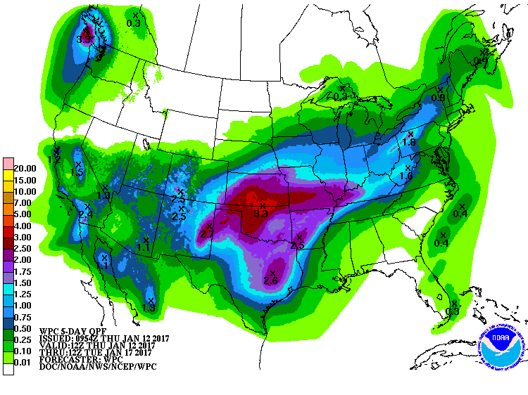
The amount of moisture with this storm is, let's say, "unusual" for January. From
2-3 inches across NW OK down to a bit less in the SE. Don't be TOO alarmed by
that in the NW. Ice accumulation is certainly not a 1:1 ratio with precipitation
totals. But 3 inches is alarming if they mostly get ice.
The good news is that's a good amount of moisture for wiping out drought in
January, a drought which is still intensifying.
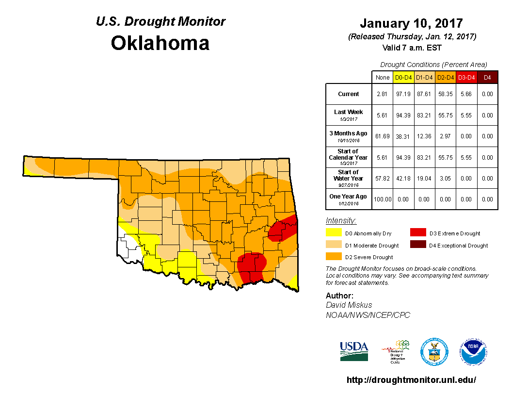
The bad news, of course, is it will probably come for much of the NW half of the
state via Mother Nature's drip irrigation system...ice.
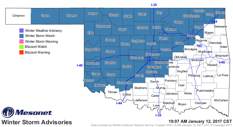
For now, we have a winter storm watch for much of that NW half of the state.
Maybe it will go to an ice storm warning, maybe not. Won't change what happens
during or after the ice.
Wasn't yesterday lovely, though?
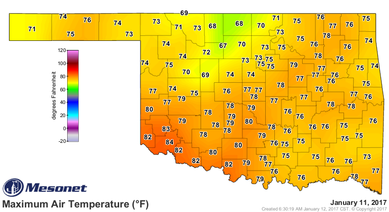
Ahhhh, yesterday. It seems like only yesterday it was yesterday. But today is
today.

Wake me up on Monday. Hopefully I'll have power (and so will my house).
Gary McManus
State Climatologist
Oklahoma Mesonet
Oklahoma Climatological Survey
(405) 325-2253
gmcmanus@mesonet.org
January 12 in Mesonet History
| Record | Value | Station | Year |
|---|---|---|---|
| Maximum Temperature | 80°F | BURN | 2000 |
| Minimum Temperature | -1°F | NEWK | 2011 |
| Maximum Rainfall | 2.10″ | DURA | 2007 |
Mesonet records begin in 1994.
Search by Date
If you're a bit off, don't worry, because just like horseshoes, “almost” counts on the Ticker website!