Ticker for October 2, 2016
MESONET TICKER ... MESONET TICKER ... MESONET TICKER ... MESONET TICKER ...
October 2, 2016 October 2, 2016 October 2, 2016 October 2, 2016
Uneven Rains Simplify Drought Picture
As a transition period between summer and fall, Mother Nature often provides
Oklahoma with a wildly varying tale to tell during September. This year was no
exception. At first glance, a description of Oklahoma?s weather during September
seems fairly straightforward ? a toasty month with an abundance of moisture in
the west and too little in the east. The state?s weather story is never quite that
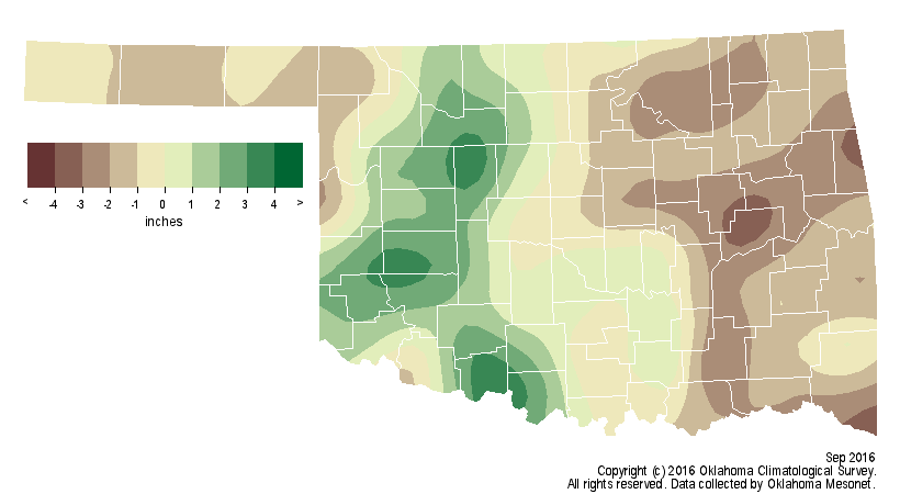
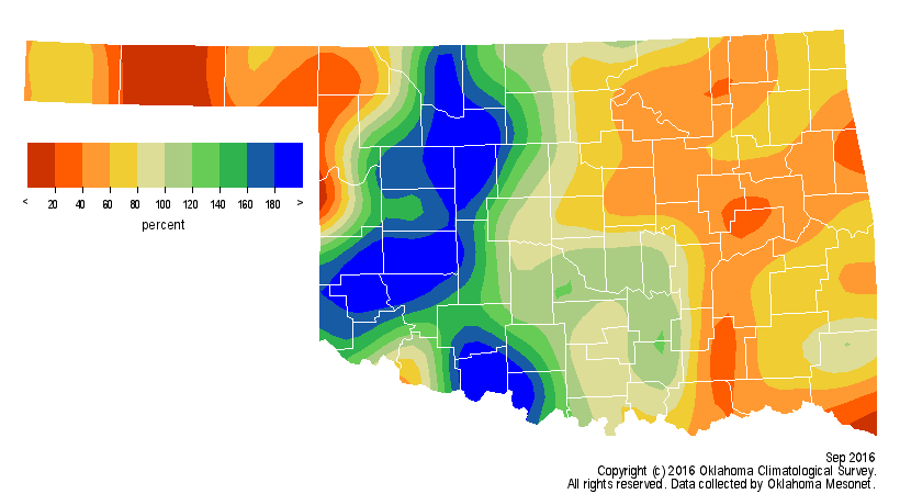
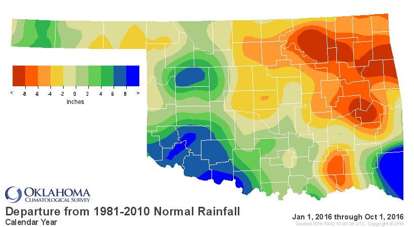
simple, of course. Far northwestern Oklahoma was actually the driest region of
the state, and parts of eastern Oklahoma enjoyed a surplus. That disparate
rainfall pattern put a halt to budding dry conditions across parts of western
Oklahoma, but intensified drought across eastern sections of the state. According
to preliminary data from the Oklahoma Mesonet, the statewide average rainfall
total was 3.14 inches, 0.39 inches below normal. Regionally, the Panhandle
suffered its 18th driest September at more than an inch below normal, west central
Oklahoma saw bountiful moisture for their 16th wettest, and east central Oklahoma
plunged more than 2 inches below normal to rank as their 35th driest.
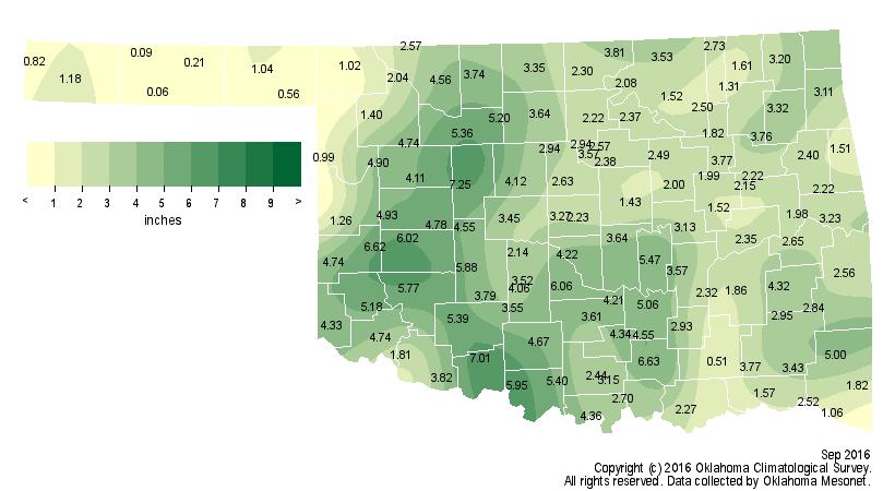
Walters led all Mesonet sites with 7.01 inches of rain for the month while
Goodwell barely wet the gauge at 0.06 inches. The rainfall for the first nine
months of the year was just as discordant as September with a surplus of more
than 5 inches in the southwest and a deficit greater than 5 inches in both the
northeast and east central sections. The statewide average for that January-
September period was 26.97 inches, about 1.5 inches below normal.
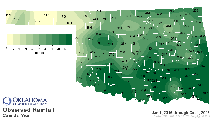

September ended as the 55th wettest on record statewide while January-September
ranked as the 57th wettest. Those records date back to 1895.
Unlike rainfall, the temperature statistics were demonstratively more uniform.
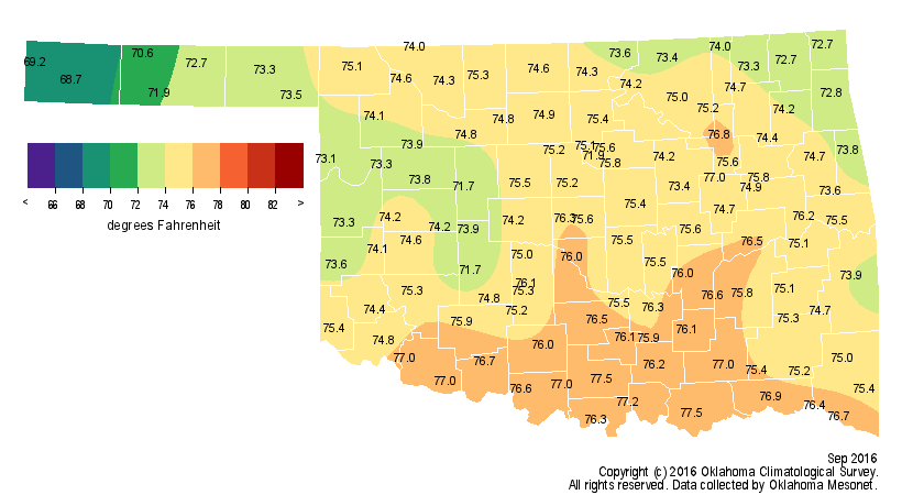
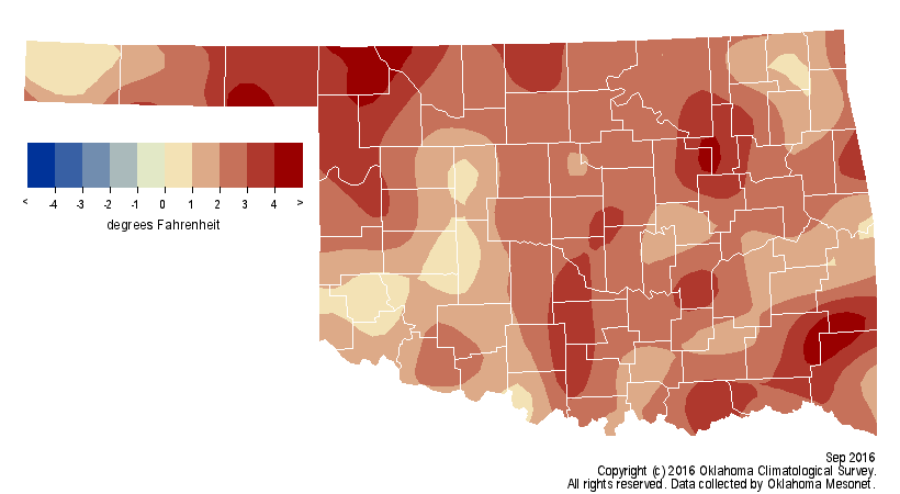
Despite a few glimpses of fall, September was unusually warm across the entire
state. According to preliminary data from the Oklahoma Mesonet, the statewide
average temperature was 74.7 degrees, 2.4 degrees above normal and the 34th
warmest September on record.
The Mesonet recorded triple-digit high temperatures seven times during
September with Buffalo leading the way at 101 degrees on the 19th. Winter made
a brief appearance at the end of the month with five readings in the 30s,
bottoming out at 37 degrees at two Panhandle stations ? Eva and Kenton ? on the
26th. September?s heat added to what has become a decidedly warm year thus far
with the January-September statewide average jumping 1.8 degrees above normal,
the 14th warmest such period on record.
While the dry conditions across western Oklahoma were eliminated by month?s end,
drought remained and even intensified across the eastern one-third of the state.
Nearly 34 percent of the state was considered abnormally dry by the U.S.
Drought Monitor at the beginning of September, and that category had been
reduced to 23 percent on the month?s final map. Actual drought, from moderate to
severe, had jumped from 14 percent to 19 percent. The worst hit areas remained
from Pontotoc County down through Atoka County in the southeast as well as from
Wagoner County through Cherokee County in the northeast. Those areas were
labeled ?severe? by the Drought Monitor. Surrounding those two areas, moderate
drought extended from the Red River to near the Kansas border. The Drought
Monitor?s intensity scale slides from moderate-severe-extreme-exceptional,
with exceptional being the worst classification.


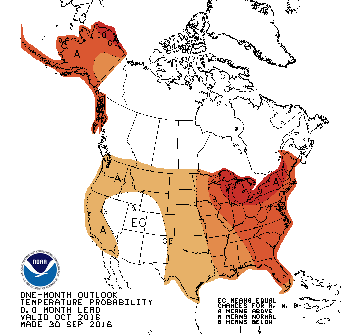
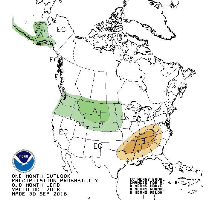
The outlooks for October from the Climate Prediction Center (CPC) see increased
odds for above normal temperatures across the entire state and below normal
precipitation across the southeastern quarter.
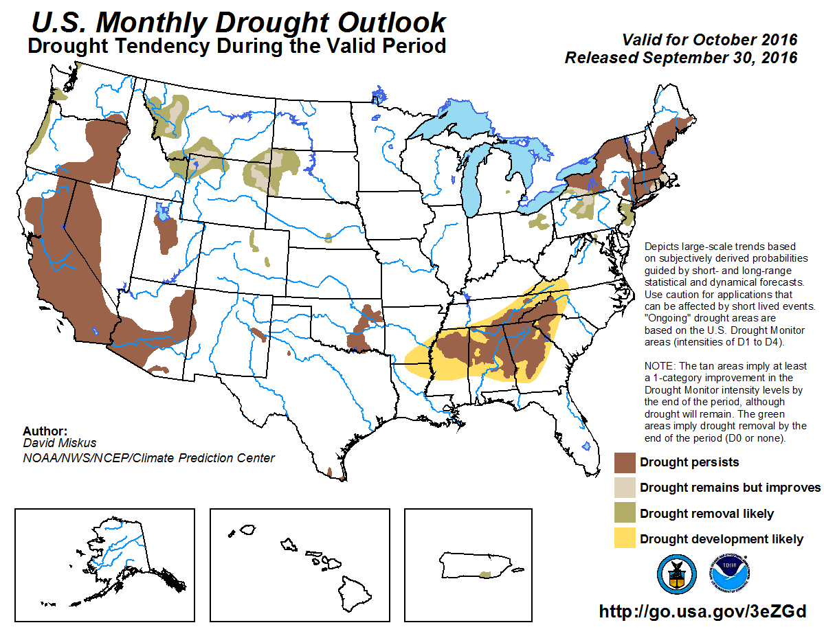
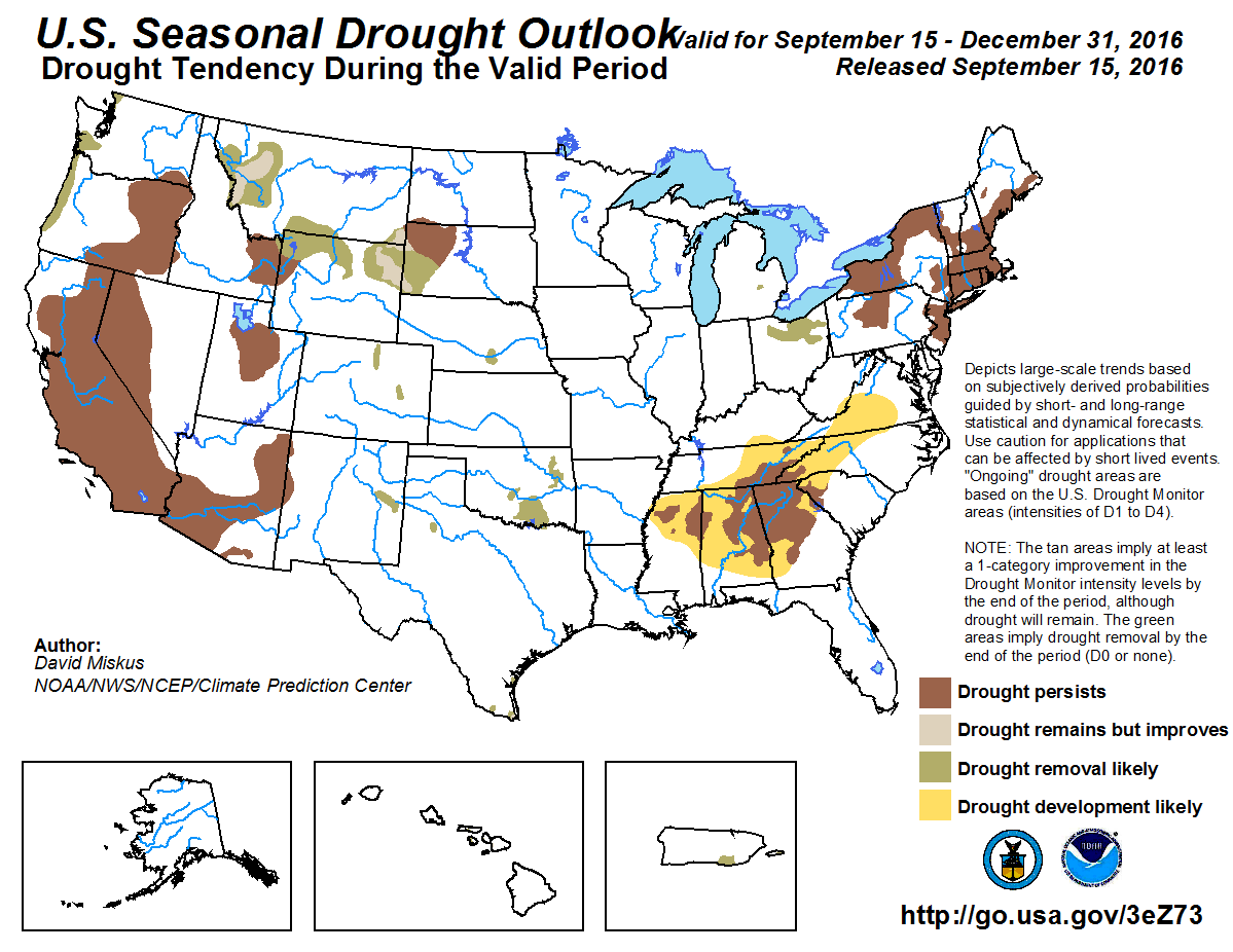
CPC?s U.S. Monthly Drought Outlook indicates the drought across eastern
Oklahoma will either persist or intensify throughout October, although the
seasonal outlook released earlier in September expected drought removed by the
end of December.
Gary McManus
State Climatologist
Oklahoma Mesonet
Oklahoma Climatological Survey
(405) 325-2253
gmcmanus@mesonet.org
October 2 in Mesonet History
| Record | Value | Station | Year |
|---|---|---|---|
| Maximum Temperature | 103°F | TIPT | 2000 |
| Minimum Temperature | 28°F | BOIS | 2009 |
| Maximum Rainfall | 4.76″ | CHER | 2002 |
Mesonet records begin in 1994.
Search by Date
If you're a bit off, don't worry, because just like horseshoes, “almost” counts on the Ticker website!