Ticker for June 30, 2016
MESONET TICKER ... MESONET TICKER ... MESONET TICKER ... MESONET TICKER ...
June 30, 2016 June 30, 2016 June 30, 2016 June 30, 2016
The drought before the storm
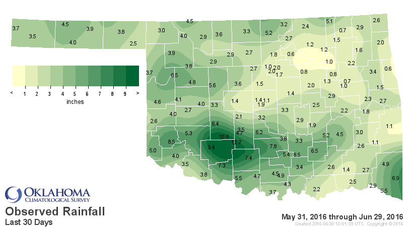
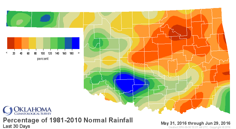
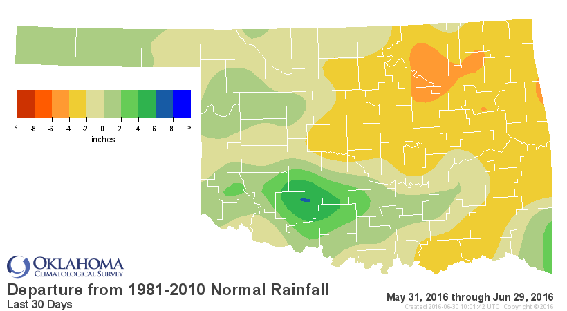
Okay, pretty simple today, and so is the Ticker. We continue to deal with growing
rainfall deficits across much of northern and eastern Oklahoma since late April
30 Days
60 days
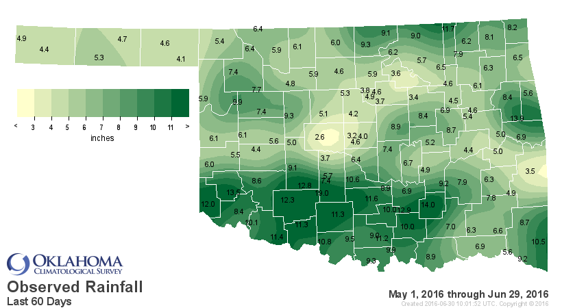
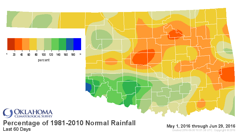

that have resulted in a return to drought (and "Abnormally Dry") conditions across
those areas of the state

So not good. Simple. What's a simple fix? Rain. Okay, here's that simple fix for
some of those areas, IF the forecasts come to fruition. With the heat dome
shifted to the SW that allows storm systems to come up and over the top of that
ridge and ride the air flow down through Oklahoma, at times bringing a cool front
along for the ride. That's what we're gonna see for the next few days. And where
that cool front stalls out, that's where the heaviest rainfall should be.
Simple. Okay, simple but complicated. Here's how our local NWS offices see this
playing out. And PLEASE keep some fuzzy lines in mind. If you're close to one
of these boundaries between rain chances or amounts, be flexible because that's
the way Mother Nature rolls.

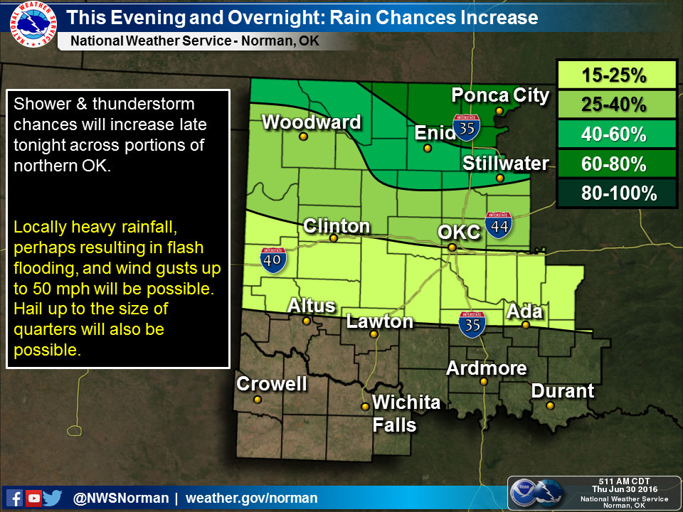
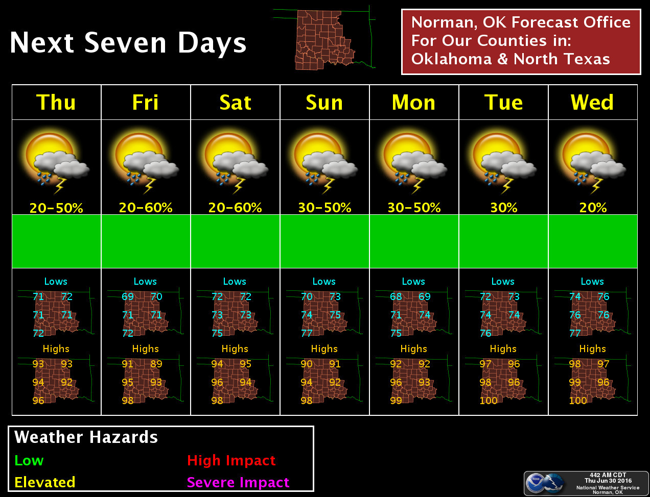
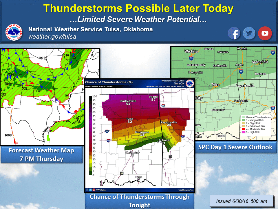
Amounts along that stalled cool front and into early next week could be quite
heavy across northern Oklahoma, reaching up into the 3-4 inch range. And
remember, if that cool front penetrates farther south, those rainfall amounts
could do the same.
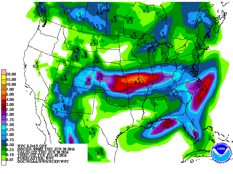
Once again, to emphasize the fragility (not the MAJOR AWARD type) of this
forecast and it's reliance upon that vagabond cool front, here's a snippet
from the Norman NWS office's forecast discussion this morning:
"Models have changed a bit with much of the rain expected to now
stay north of the (forecast area tonight into Friday. Models do not have the
front coming as far south as previous runs so the best chances for
rain shift north. Despite that, showers and storms will still
remain possible in parts of the area through Friday just have
confined (rain chances) a little further north. Models now show the better
chance for rain in the area will be this weekend. A shortwave
trough will move out of the Southwest U.S. into the
Central/Southern Plains. Models also show a frontal boundary in
the (forecast area) which along with the shortwave will bring a good chance
for showers/storms to parts of the (forecast area) this weekend. Rain
chances will continue into early next week."
More of the same from the Tulsa NWS office, but with a bit more on what's going
to happen (maybe) next week:
"A more defined wave approaches the Plains on Saturday with the
warm sector spreading northward and taking the more widespread
rains well north of the area. This will allow temps on Saturday to
warm well above normal and a run at triple digit heat is not out
of the question for some locations. The weak cold front associated
with the aforementioned wave increases precip chances Sun night
through Monday as it stalls across the region and gradually loses
definition. Thereafter upper ridging dominates at least through
the remainder of the work week with hot and dry wx prevailing."
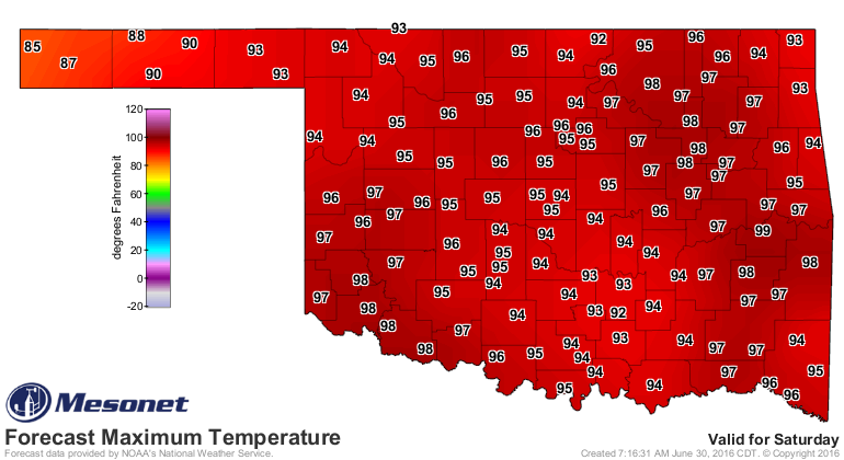
So Saturday could be a scorcher!
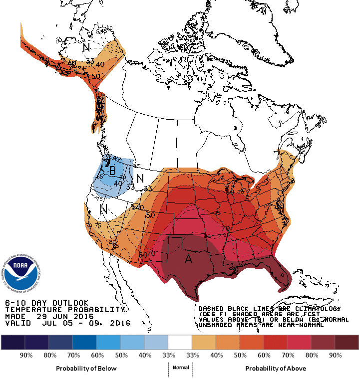
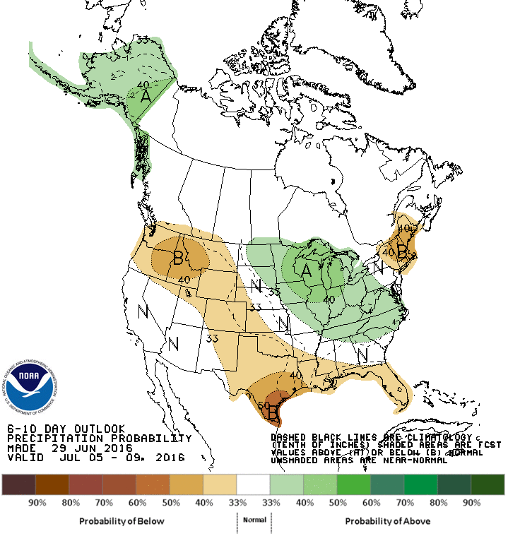
And next week will be, well, very July-ish.
So there you have it, the simplicity of Mother Nature all laid out before you
with all the "ifs," "buts" and "you're nuts!" included. Your fortunes depend on
a measly little cool front. Welcome to uncertainty.
Gary McManus
State Climatologist
Oklahoma Mesonet
Oklahoma climatological Survey
(405) 325-2253
gmcmanus@mesonet.org
June 30 in Mesonet History
| Record | Value | Station | Year |
|---|---|---|---|
| Maximum Temperature | 109°F | HOOK | 2012 |
| Minimum Temperature | 55°F | SEIL | 2008 |
| Maximum Rainfall | 5.07 inches | BUFF | 1999 |
Mesonet records begin in 1994.
Search by Date
If you're a bit off, don't worry, because just like horseshoes, “almost” counts on the Ticker website!