Ticker for July 1, 2016
MESONET TICKER ... MESONET TICKER ... MESONET TICKER ... MESONET TICKER ...
July 1, 2016 July 1, 2016 July 1, 2016 July 1, 2016
June Sees Drought's Return
As has been the case for the last several months, some of this info has already
been impacted by big weather on the month's final day with yesterday's storms
already altering parts of the newly minted drought area (Pawnee County, we see
you).
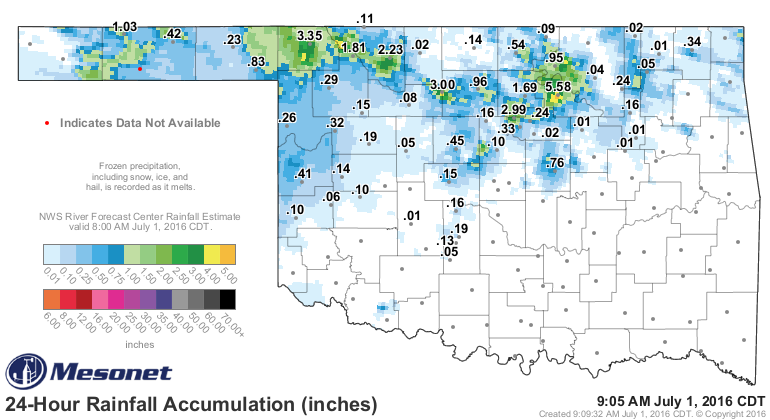
Regardless, much of what we showed you yesterday still holds true with a good
chance of rain over the next few days, mainly for northern Oklahoma. Hopefully
that will shift just a bit farther south and hit central Oklahoma with a good
dose of moisture as well.
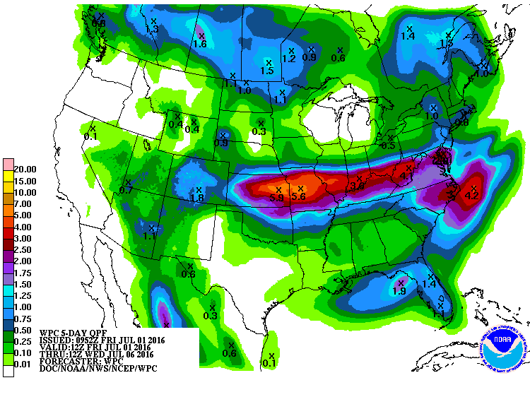
Still hot and humid next week. Enjoy your holiday weekend! Here's some lightly
written reading material over June's weather to put you to sleep...I mean to
start your holiday weekend off to a relaxing start.
-------------------------------------------------------------------------------
June Sees Drought's Return
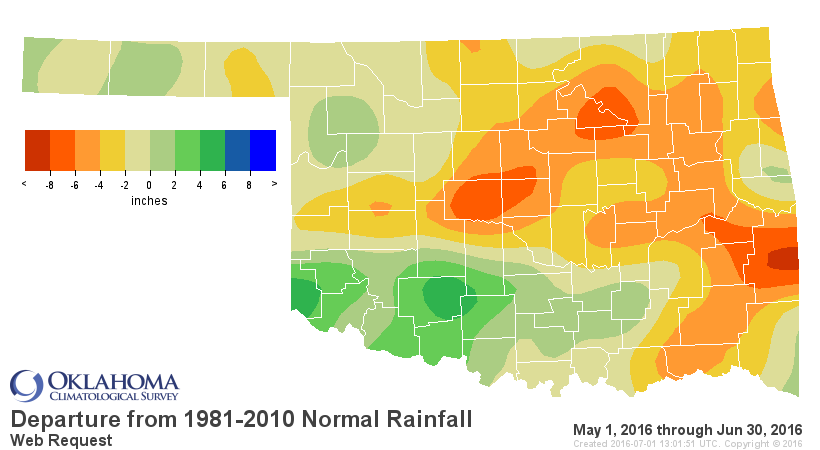
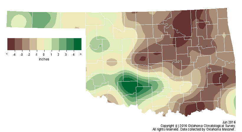
Lack of rain and hot weather took its toll during June, allowing drought to
make a comeback from central through northeastern Oklahoma. Moisture deficits
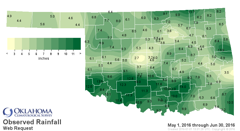
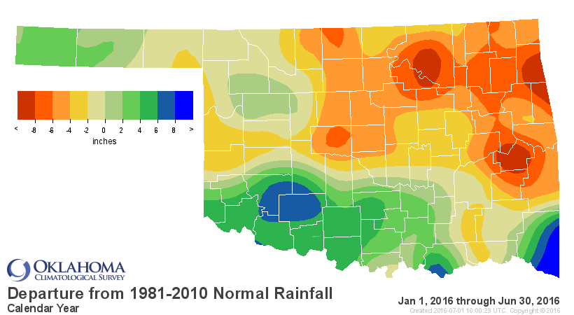
dating back to late April rose to 4-8 inches across a large swath of northern
and eastern Oklahoma. During that period, heavy rains inundated southern
Oklahoma at times and prompted numerous flash flood warnings. To highlight the
disparity in moisture, the El Reno Mesonet site in central Oklahoma recorded a
scant 2.7 inches of rain since May 1 while Mangum totaled a whopping 13.5 inches
in the far southwest.
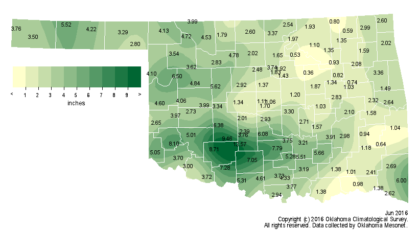
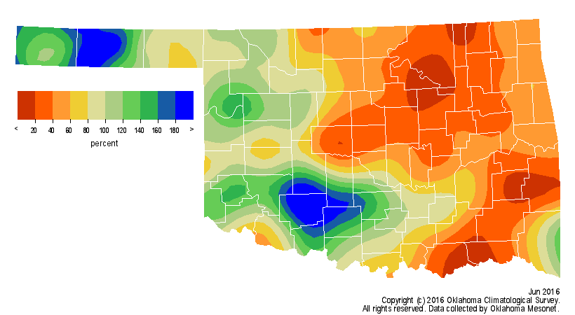
June itself ended as the 48th driest on record for the state according to
preliminary data from the Oklahoma Mesonet with a statewide average of 3.3
inches, 1.3 inches below normal. The moisture disparity across the state was
extreme, however. Northeastern Oklahoma experienced its third driest June on
record at 3.8 inches below normal. Southwestern Oklahoma saw its 17th wettest
at 1.5 inches above normal. Acme led all Mesonet sites with 12.6 inches of rain
during June while Oilton had the lowest total of 0.4 inches.
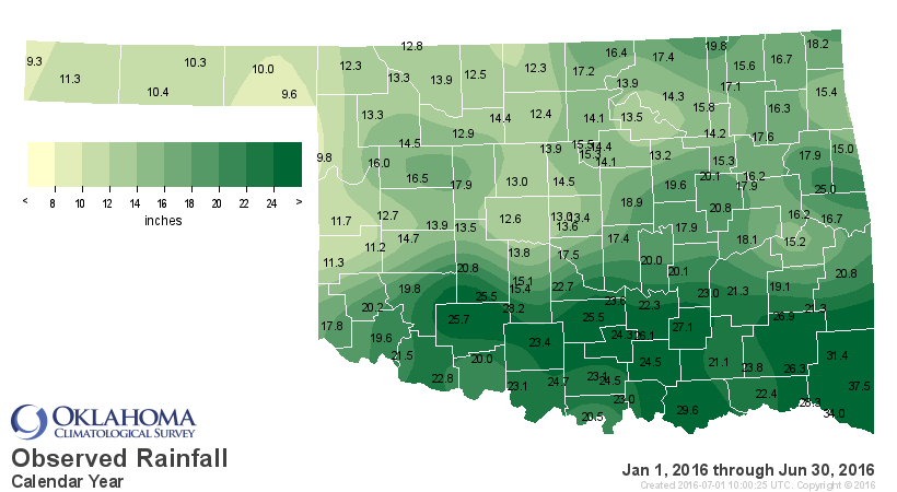
The January-June statewide average fell 1.8 inches below normal at 17.2 inches.
Kenton has received 9.3 inches for the lowest 2016 total thus far. Broken Bow
leads the state with 37.4 inches.
The early return to summer during June helped intensify the drought and
produced miserable conditions for Oklahomans. A large area of high pressure ?
summer?s typical ?heat dome? ? camped over the Southern Plains through much of
June?s last three weeks and ramped up the temperature. Mesonet sites across
northern and southwestern Oklahoma recorded triple digits several times during
the month. Kingfisher hit the 100-degree mark seven times to lead the state.

Ample moisture flow from the Gulf of Mexico combined with those high
temperatures to create oppressive conditions, particularly during a three-day
period from June 15-17. Heat index values reached highs of 117 degrees at
Bixby, Marena and Oilton on the 15th (NOTE: this map shows the heat index values
as of 2:25 pm on June 15)
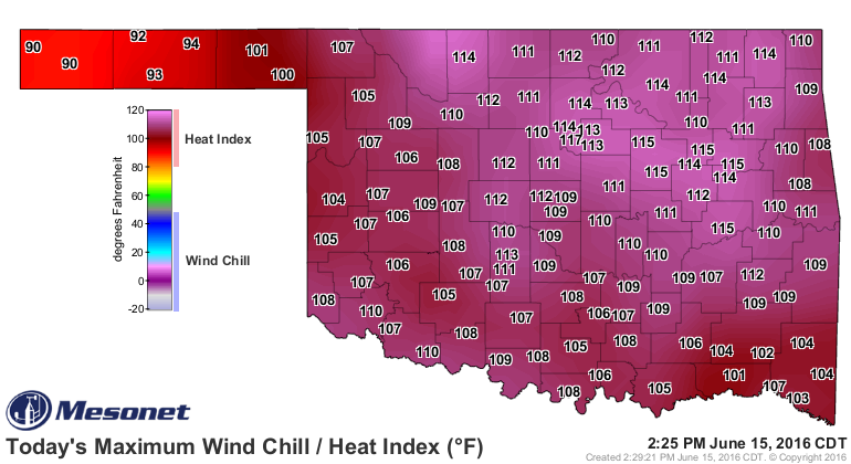
and there were 151 instances of 110 degrees or greater calculated by the
Mesonet during that three-day period. The Mesonet recorded 437 heat index
values of 105 degrees or higher during the month. The June statewide average
temperature of 78.9 degrees was 2.4 degrees above normal, the 27th warmest June
on record.
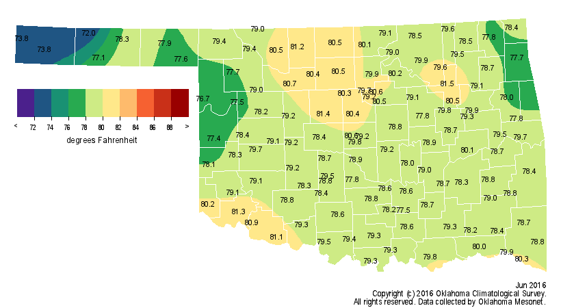

Several Mesonet sites reached 104 degrees for the month?s highest temperature
while a low of 46 degrees at the Mesonet?s newest station, Eva in Texas County,
was the lowest reading. The January-June statewide was 2.1 degrees above normal
and the eighth warmest first half of the year on record.
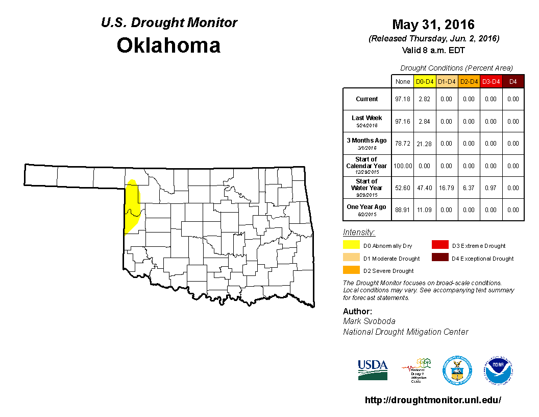
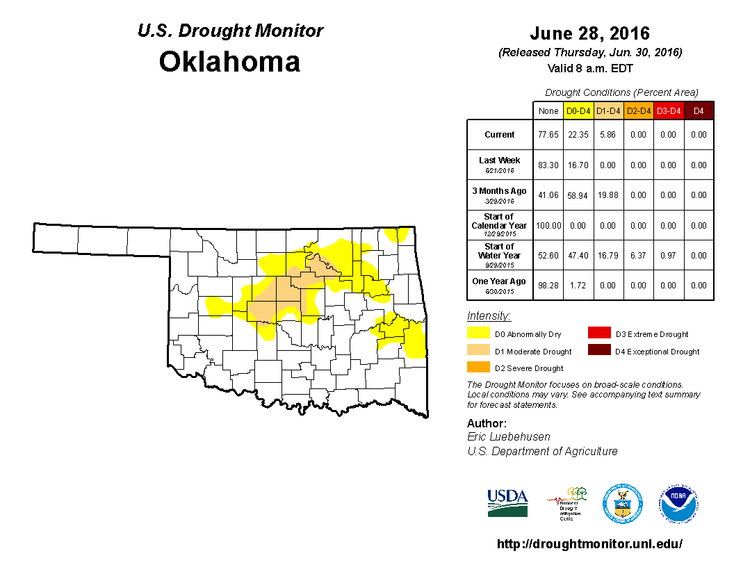
The month started with just three percent of the state in ?Abnormally Dry?
conditions, but no drought indicated according to the U.S. Drought Monitor. The
Drought Monitor map was completely clear in Oklahoma on June 14, but the heat
and lack of rainfall eventually took its toll, prompting the return to drought
on June?s last day. That last report had six percent of the state in moderate
drought and 17 percent in abnormally dry conditions.

On the opposite side of the hazard scale, flooding was an oft-reported problem
during June. Lawton suffered widespread flash flooding on both June 2 and June
13 after heavy rains, necessitating water rescues by emergency personnel during
both events. Flash flood warnings and water rescues were common during the
first half of the month across the southwestern quarter of the state. Scattered
storms on the month?s final day brought high winds, large hail and localized
heavy rainfall to parts of Oklahoma.
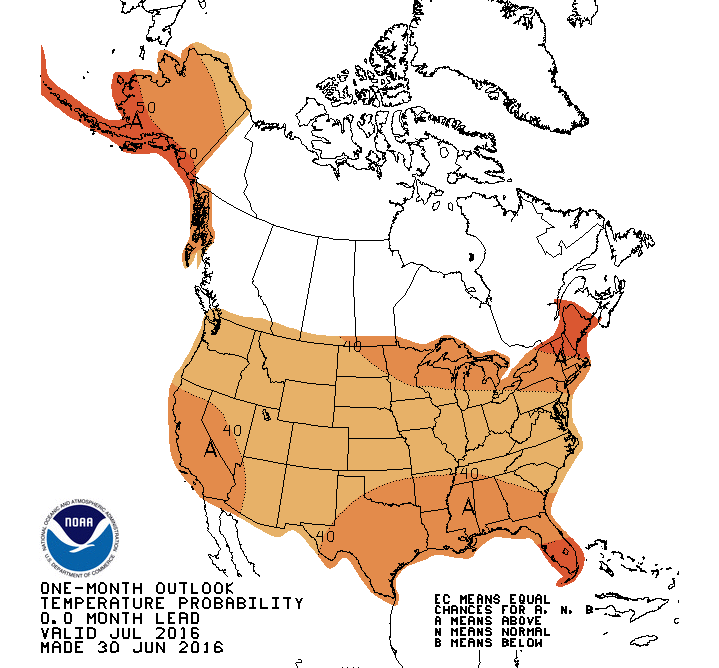
The Climate Prediction Center?s outlooks for July indicate increased odds of
above normal temperatures across the entire United States, although odds are a
bit higher across the Southeast, including southeastern Oklahoma.
The precipitation outlook is non-committal with equal odds of near-, above- or
below-normal precipitation.

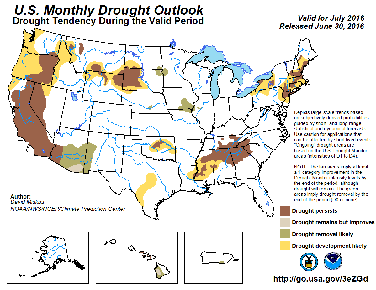
The U.S. Drought Outlook for July expects the current Oklahoma drought area will persist and possibly intensify through the end of the month with the areas surrounding it facing possible drought development.
Gary McManus
State Climatologist
Oklahoma Mesonet
Oklahoma Climatological Survey
(405) 325-2253
gmcmanus@mesonet.org
July 1 in Mesonet History
| Record | Value | Station | Year |
|---|---|---|---|
| Maximum Temperature | 110°F | ALVA | 1997 |
| Minimum Temperature | 50°F | EVAX | 2017 |
| Maximum Rainfall | 5.82 inches | PAWN | 2016 |
Mesonet records begin in 1994.
Search by Date
If you're a bit off, don't worry, because just like horseshoes, “almost” counts on the Ticker website!