Ticker for June 1, 2016
MESONET TICKER ... MESONET TICKER ... MESONET TICKER ... MESONET TICKER ...
June 1, 2016 June 1, 2016 June 1, 2016 June 1, 2016
May sees plenty of severe weather

Okay, maybe YOU didn't see a lot of severe weather (lucky you), but you probably
saw SOME. That's the way this May worked with severe weather occurring somewhere
in the state on 16 out of the 31 days in the month, whether that be Kenton, Idabel,
Miami or Hollis. Or Buffalo (yes, it saw severe weather, which is important since
it's Buffalo). At any rate, as the rain falls and we deal with flooding (yep,
that's severe weather believe it or do)
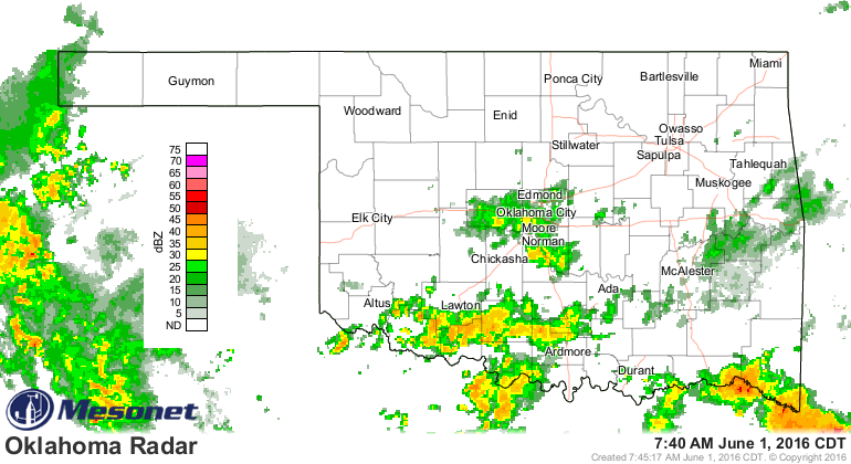
and we see it will probably stick around for a day or two

stick around because it will clear up just in time for the weekend and you can
get back to cutting wheat or playing in the sun or whatever it is that you do
when it's not raining during the summer.

And now, a brief summary of May's sometimes tumultuous weather.
------------------------------------------------------------------------------
Known as the state?s most active severe weather month, May tried to live up to
that moniker with several extended periods of threatening weather. Although it
didn?t quite match some of the more ferocious Mays since the beginning of the
decade,
http://ticker.mesonet.org/select.php?mo=06&da=04&yr=2010
http://ticker.mesonet.org/select.php?mo=06&da=01&yr=2011
http://ticker.mesonet.org/select.php?mo=06&da=02&yr=2013
http://ticker.mesonet.org/select.php?mo=06&da=01&yr=2015
it was still quite lively nonetheless. At least one instance of severe weather
was reported somewhere in the state on 16 of the 24 days between May 8 and May
31. The National Weather Service published a preliminary count of 19 tornadoes
during May, four short of average for the month. That total could rise with
further investigation, however, including the possibility of several weak
tornadoes on the month?s final day in central Oklahoma. The preliminary count
for the year thus far stands at 49.
May 9 was the most violent day with at least 12 tornadoes being reported. That
total included several significant tornadoes across south central Oklahoma that
left two dead and several others injured. The two fatalities, both 76 year old
males, occurred near Katie in an EF-4 monster that churned through Garvin
County and near Connerville in an EF-3 tornado. The Sulphur Mesonet site
recorded a wind gust of 88 mph associated with those storms, and softball size
hail fell near Wapanucka in Coal County.
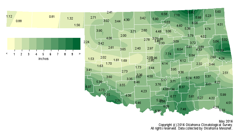
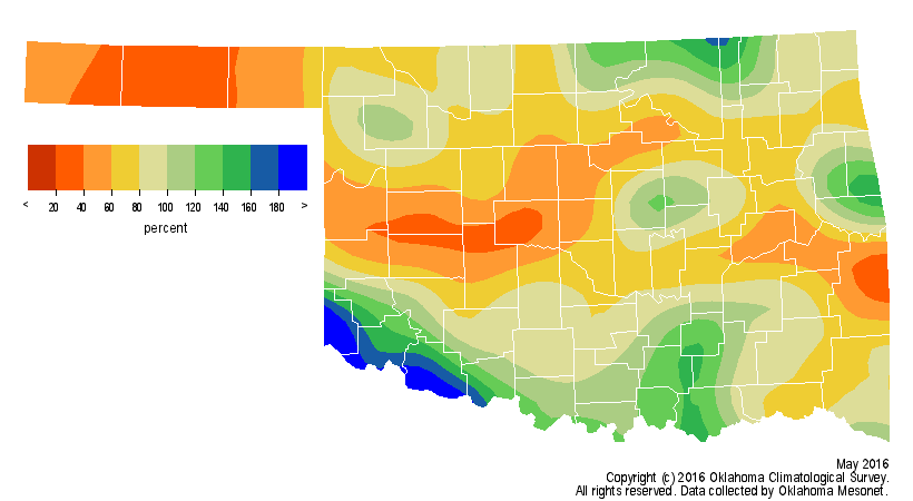
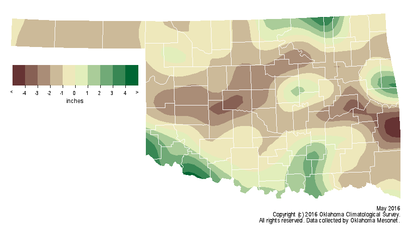
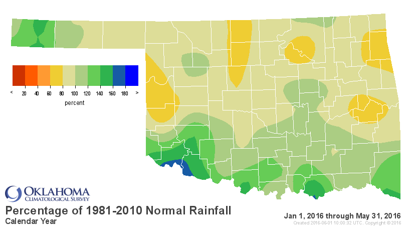
Despite the active weather, May ended drier than normal across much of the
state. Data from the Oklahoma Mesonet estimate a statewide average of 4.12
inches, 0.70 inches below normal and the 51st driest May since records began in
1895. As is customary for convective precipitation, however, the fortunes of
differing areas of the state varied dramatically. Far southern Oklahoma
received 5-8 inches while west central Oklahoma totaled 1-2 inches. In fact,
much of the state saw rainfall totals drop from 1-4 inches below normal. May
rainfall totals from the Mesonet ranged from 12.39 inches at Cookson to less
than an inch at two Panhandle locations.
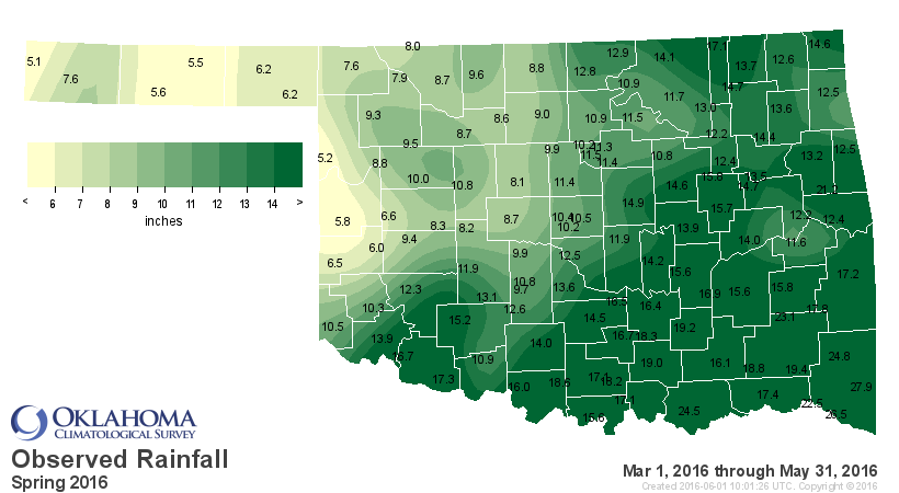
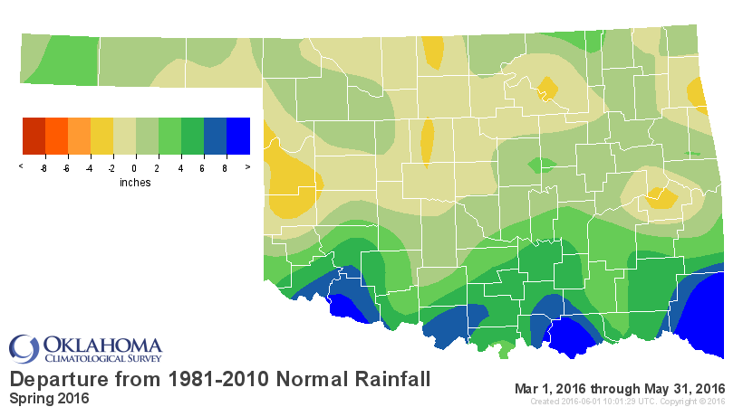
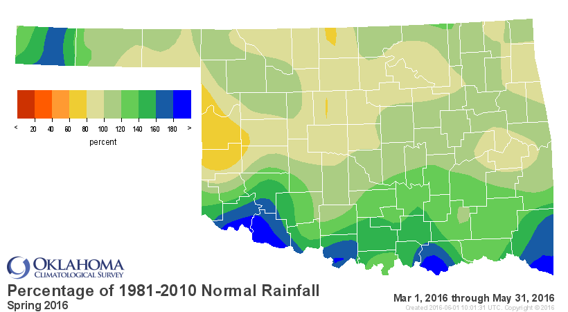
Despite the disappointing rainfall totals, the climatological spring season
(March-May) ended as the 31st wettest since 1895 with a statewide average of
12.34 inches, about an inch above normal. Again, some areas fared better than
others over the season with south central Oklahoma seeing its 11th wettest
spring while west central sections experienced their 55th driest.
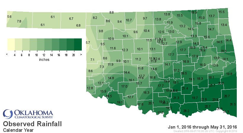
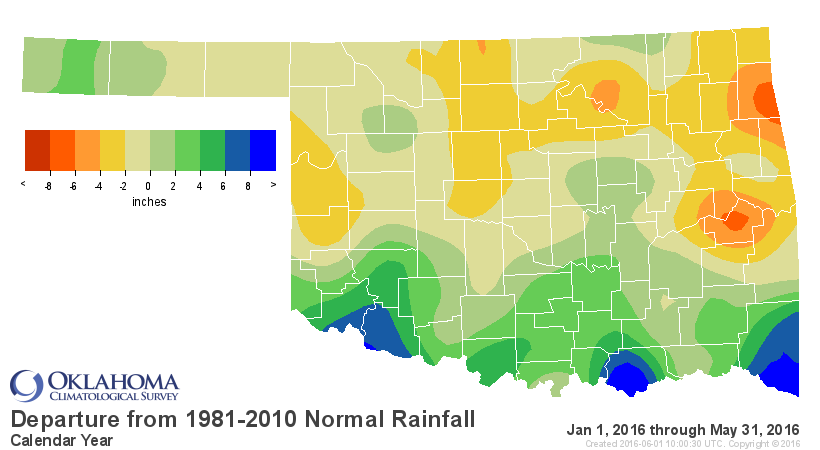
Those same variations were exhibited in the year to date rainfall statistics as
well with the 24th wettest January-May on record for south central Oklahoma and
the 35th driest for west central sections. Overall, the first five months of
the year were about an inch below normal at 13.88 inches.
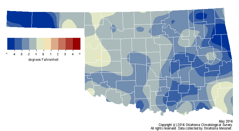
May was unusual not only for its lack of rainfall, but also for its lack of
warmth. According to preliminary data from the Oklahoma Mesonet, the statewide
average temperature for the month was 65.9 degrees, 2.3 degrees below normal to
rank as the 21st coolest May since records began.
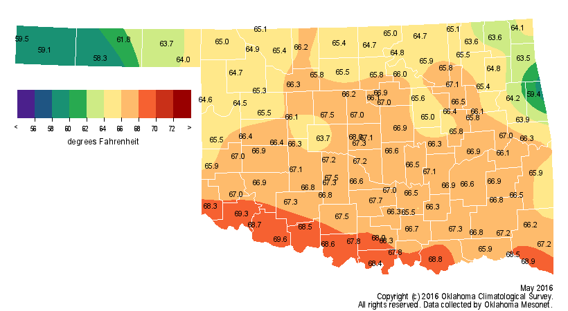
None of the 120 Mesonet stations observed a triple-digit high temperature
during May. The month?s last freeze ? and lowest temperature of the month ? was
recorded at Boise City with 31 degrees on May 2. The highest temperature was 99
degrees at Altus on May 10. Despite the cool May, the spring season was the
25th warmest on record with a statewide average of 60.7 degrees, 1.4 degrees
above normal. The first five months of the year exceeded normal by 2 degrees,
the tenth warmest January-May on record.
The June outlooks from the NWS? Climate Prediction Center (CPC) call for
increased odds of below normal temperatures across all of Oklahoma and above
normal precipitation across southern Oklahoma.


Those outlooks are based upon forecasts for heavy precipitation and the
associated lack of sunshine during the first week of June according to CPC
forecasters. The strong El Ni?o that impacted weather across the globe,
including the enhanced rainfall amounts of 2015 in Oklahoma, has all but ended.
Forecasters at CPC now conclude the equatorial pacific waters will enter
neutral conditions for a few months before quickly transitioning to La Ni?a
during the summer and then strengthen through this fall and winter. While there
is no indication yet of the strength of this La Ni?a, possible impacts include
drier and warmer than normal weather from late fall through mid-spring 2017.
Gary McManus
State Climatologist
Oklahoma Mesonet
Oklahoma Climatological Survey
(405) 325-2253
gmcmanus@mesonet.org
June 1 in Mesonet History
| Record | Value | Station | Year |
|---|---|---|---|
| Maximum Temperature | 110°F | ALTU | 1998 |
| Minimum Temperature | 44°F | OILT | 2012 |
| Maximum Rainfall | 6.51 inches | OKEM | 2013 |
Mesonet records begin in 1994.
Search by Date
If you're a bit off, don't worry, because just like horseshoes, “almost” counts on the Ticker website!