Ticker for February 11, 2016
MESONET TICKER ... MESONET TICKER ... MESONET TICKER ... MESONET TICKER ...
February 11, 2016 February 11, 2016 February 11, 2016 February 11, 2016
La Nina looming?
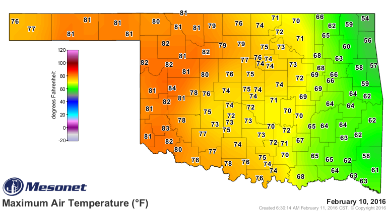
ZOUNDS! Look at those high temperatures from yesterday. Now that's what I call
spring. Eastern Oklahoma, still under the influence of that back-door cold air
mass that slid off the the east remained 10-20 degrees cooler than the west, but
that's what you'll see during this type of pattern.
With that polar vortex'ish thingy (yes, that is a scientific term) slipping down
from the north and a large ridge dominating the west's weather, Oklahoma remained
in that transition zone. So much like the previous few winters, that type of
pattern means brushes with really warm air and really cold air, and when we get
those cold fronts with the really cold air, they are usually quick moves and
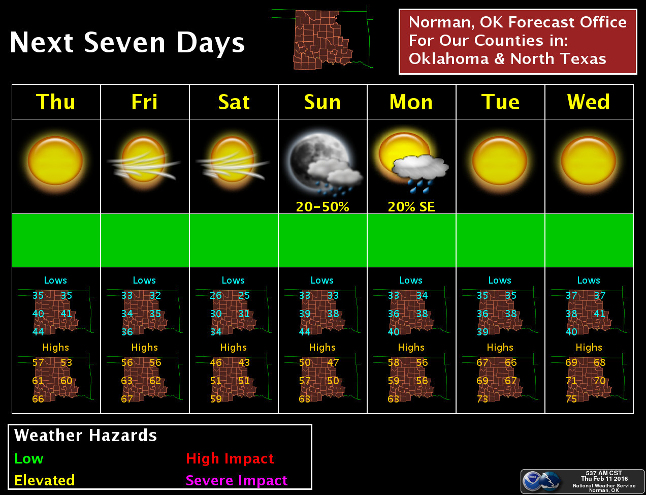
mostly dry. That means fire danger, of course. Now we get to suffer through a
bit of a cool stretch through the weekend, relatively speaking, of course, before
another nice warm up next week. And maybe a chance of rain for awhile on Sunday
and Monday -- mostly for eastern OK.
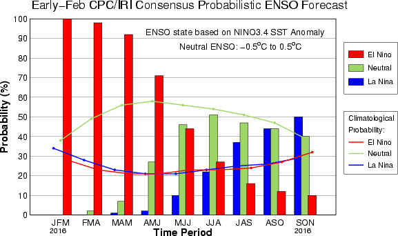
But we've talked about that to death this week. Let's look at the newest ENSO
(El Nino/Southern Oscillation) update from the NWS' Climate Prediction Center.
What we see is more evidence of the El Nino beginning to fade away to
"neutral conditions" in late spring and early summer, and a burgeoning movement
amongst the forecasters to see a La Nina episode develop this fall and winter.
There is much caution intoned, however, due to the skill of the forecast
information this far in advance. Here is a snippet from their report, which you
can find here:
http://www.cpc.ncep.noaa.gov/products/analysis_monitoring/enso_advisory/ensodisc.html
"Most models indicate that El Ni?o will weaken, with a transition to
ENSO-neutral during the late spring or early summer 2016. Thereafter,
the chance of La Ni?a conditions increases into the fall.
While there is both model and physical support for La Ni?a following
strong El Ni?o, considerable uncertainty remains. A transition to
ENSO-neutral is likely during late Northern Hemisphere spring or early
summer 2016, with a possible transition to La Ni?a conditions during
the fall."
These graphics show the forecast model output that depicts that sharp decline
from El Nino to Neutral to La Nina as we go through the year, and the chances
for each phase of the oscillation as we go through time.

So while we have been dry for about 40 days or so now, the expectation of
wetter than normal weather for Oklahoma is still there, at least on the last
Seasonal Outlook issued about 3 weeks ago. This will be updated next week, but
I would expect a similar look to that map for March-May as we see in this one
for February-April.
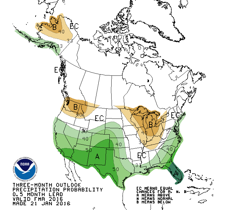
Let's be honest though. The expected El Nino impacts never arrived during
February, and therefore the February outlook failed miserably.
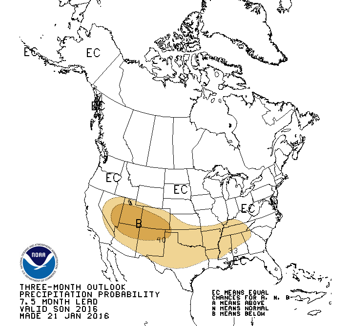
November and December certainly didn't, however. And as I said, we can start to
see the influence of that possible La Nina on the seasonal outlooks as early as
the September-November period for this coming fall -- just in time for the fall
planting period.
We're not trying to alarm anybody, and we're definitely not saying the outcomes
for these outlooks are set in stone. But it is important to remember that there
is precedence for a strong El Nino to be followed by La Nina conditions. We
should also not be lulled into thinking any significant impacts are over due to
our dry January-February. Obviously there are other things that impact our
weather, and in reality the ENSO signal can only account for about 30% of those
governing patterns.
What's it all mean? Well, what we always warn about with Oklahoma weather: never
get lulled into complacency by the current weather pattern, whether we're talking
on a weekly, monthly, or even seasonal scale. There's usually something different
waiting just around the corner.
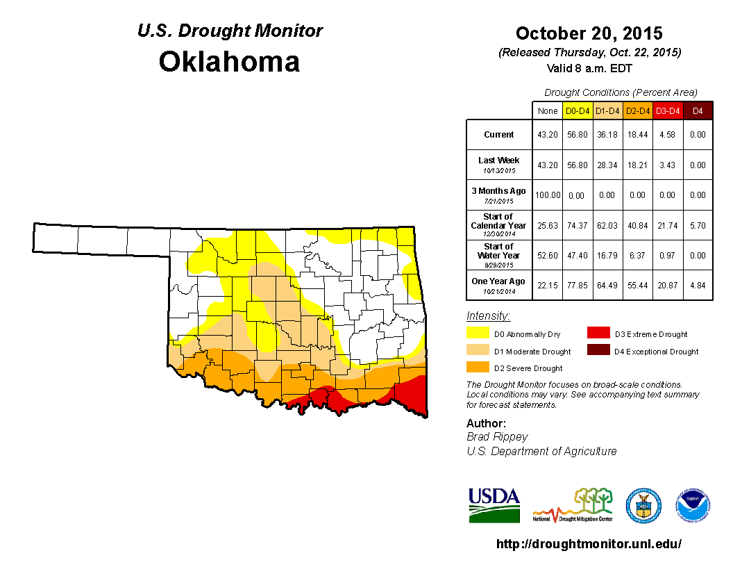
One final word of caution...if we HADN'T had that lovely/disastrously wet
November/December period, we'd be sitting smack dab in the middle of a 6-month
dry pattern, and undoubtedly a state full of moderate to at least extreme
drought, as evidenced by the drought monitor map at the end of October. A preview
of next fall and winter? I hope not.
Gary McManus
State Climatologist
Oklahoma Mesonet
Oklahoma Climatological Survey
(405) 325-2253
gmcmanus@mesonet.org
February 11 in Mesonet History
| Record | Value | Station | Year |
|---|---|---|---|
| Maximum Temperature | 99°F | MANG | 2017 |
| Minimum Temperature | -6°F | PRYO | 2011 |
| Maximum Rainfall | 1.27 inches | VANO | 2008 |
Mesonet records begin in 1994.
Search by Date
If you're a bit off, don't worry, because just like horseshoes, “almost” counts on the Ticker website!