Ticker for February 1, 2016
MESONET TICKER ... MESONET TICKER ... MESONET TICKER ... MESONET TICKER ...
February 1, 2016 February 1, 2016 February 1, 2016 February 1, 2016
El Ni?o?s Impacts Fizzle During January
Considering the extreme precipitation that ended 2015, and with the ?super? El
Ni?o that boosted the November-December period to the wettest on record for the
state still in place, January was a veritable dud. According to preliminary data
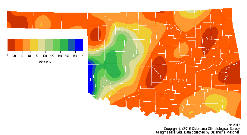
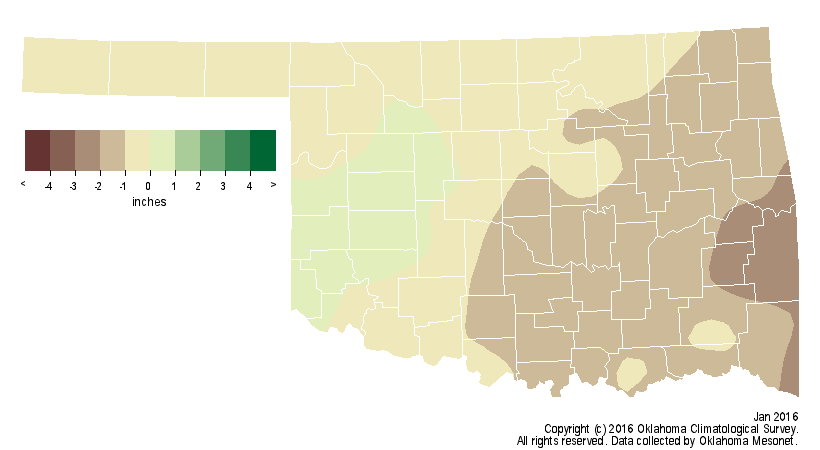
from the Oklahoma Mesonet, the statewide average precipitation total was 0.71
inches, nearly an inch below normal and the 28th driest January since records
began in 1895.
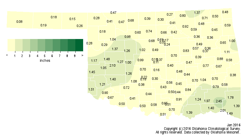
Only 29 of the Mesonet?s 120 stations recorded at least an inch of rain, and only
three exceeded 2 inches. Cloudy led all Mesonet sites with 2.45 inches. Boise
City recorded a state low of 0.08 inches. Oklahoma City?s official observing site
at Will Rogers Airport received 0.11 inches, the 12th driest January on record
dating back to 1891. Tulsa fared a bit better with 0.61 inches, the 24th driest
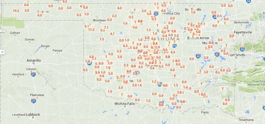
dating back to 1894. Some of the precipitation across the state fell as snow
and ice, but those totals were fairly limited. The National Weather Service
cooperative observer at Sayre recorded a respectable 3.8 inches for the state?s
largest official total. Boise City still led the seasonal total with 19.5
inches of snowfall. Arnett was a distant second with 11.2 inches. Those are the
only official observing sites with double-digit seasonal snowfall totals thus
far.
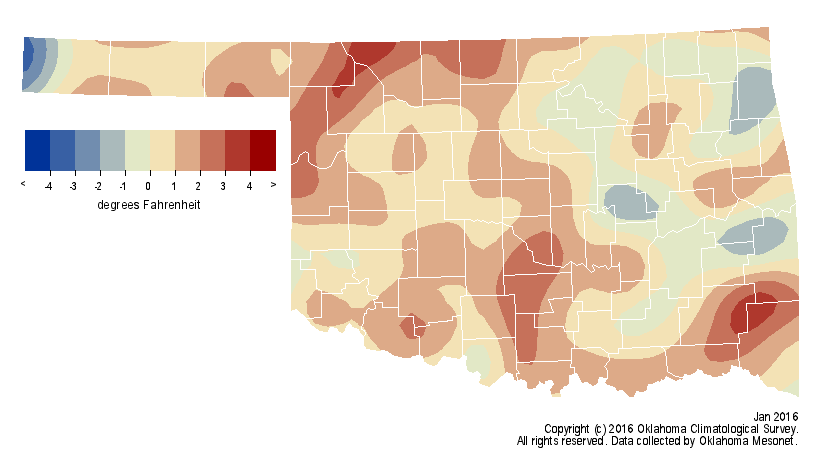
Similar to precipitation, the relative warmth of the last two months of 2015
faded soon after Christmas, not to return until the end of January. The
November-December period was more than 4 degrees above normal and the fourth
warmest on record. Despite the return to more seasonable weather, however, the
month still finished above normal according to Mesonet data. The statewide
average of 38.2 degrees was half a degree above normal to rank as the 49th
warmest on record.
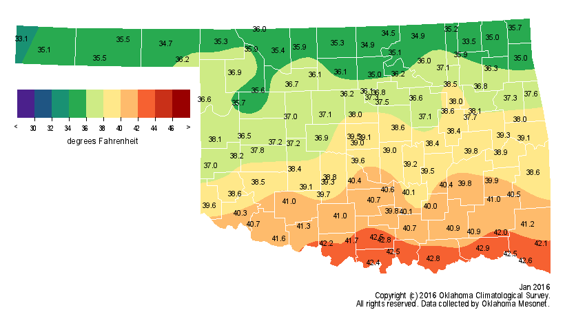
While it never got exceptionally cold in the state ? the lowest temperature
recorded by the Mesonet was a mere 4 degrees at Kenton on the 11th, fairly
benign by January?s standards ? we did not see those high temperatures rebound
back into the 70s and 80s until the month?s final week. Southwestern Oklahoma
received a sneak preview of summer with widespread 80s on the 29th and 30th.
Hollis reached the month?s highest temperature of 85 degrees on the 30th.
Oklahoma City and McAlester either tied or broke high temperature records on
the 29th and 30th. The warmth and lack of moisture combined with high winds to
create elevated wildfire danger at the end of the month. Wildfires were
reported across many areas in central and western Oklahoma.
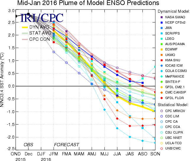
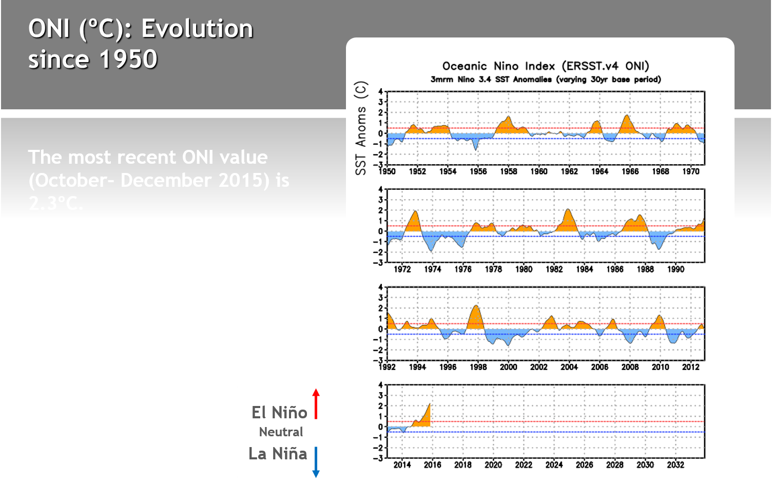
The strong El Ni?o that many experts attribute, at least partially, Oklahoma?s
record breaking 2015 rainfall to has peaked according to Climate Prediction
Center (CPC) forecasters. The phenomenon is expected to gradually weaken
through spring 2016 before transitioning to neutral conditions during the late
spring or early summer.
Given that El Ni?o conditions are still present and relatively strong, impacts
for the Southern Plains and Oklahoma will remain possible. CPC forecasters see
increased odds of above normal precipitation for February and then for each
three-month period from March-May through April-June. Those enhanced odds
diminish from east to west across Oklahoma as spring unfolds, disappearing from
the state as summer begins.
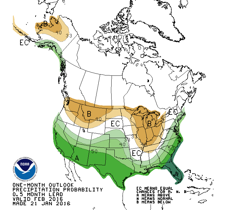
http://www.cpc.ncep.noaa.gov/products/predictions/long_range/
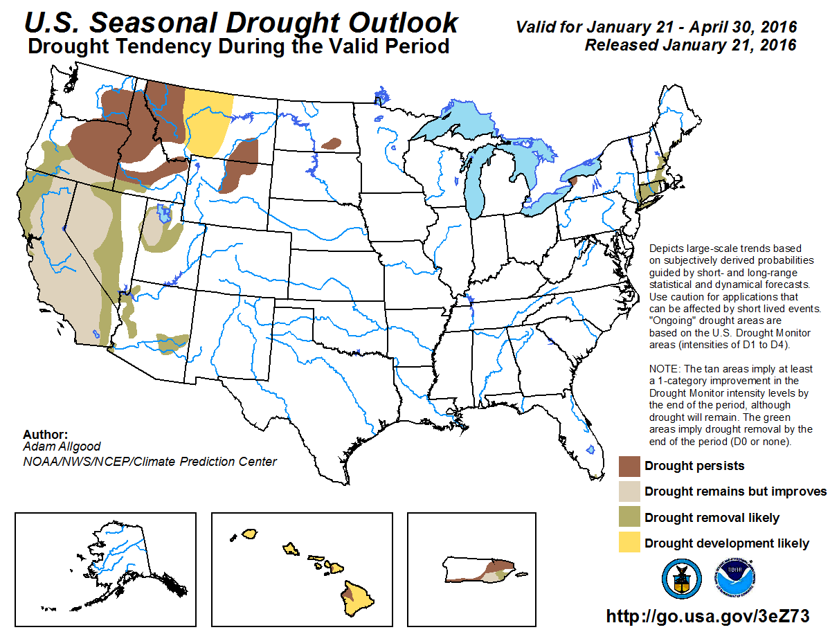
Based upon that scenario, CPC?s U.S. Seasonal Drought Outlook for February
through April does not indicate any drought development across Oklahoma.
It must be noted, however, that the consensus computer model forecast for the
equatorial pacific waters later into fall and winter 2016 is for La Ni?a to
develop. La Ni?a events can create the opposite of conditions that Oklahoma saw
during 2016, with increased odds of a drier and warmer late fall through spring.
The La Ni?a events of 2010-11 and 2011-12 were thought to have aided the
beginning of the damaging five-year drought that struck the Southern Plains and
Oklahoma from 2010-15. Sea surface temperature forecasts for next fall should
be considered very preliminary at this time, but there is historical precedence
for a strong El Ni?o to be followed by La Ni?a according to climate experts.
Gary McManus
State Climatologist
Oklahoma Mesonet
Oklahoma Climatological Survey
(405) 325-2253
gmcmanus@mesonet.org
February 1 in Mesonet History
| Record | Value | Station | Year |
|---|---|---|---|
| Maximum Temperature | 81°F | SLAP | 2003 |
| Minimum Temperature | -7°F | BOIS | 2011 |
| Maximum Rainfall | 1.61 inches | MTHE | 2011 |
Mesonet records begin in 1994.
Search by Date
If you're a bit off, don't worry, because just like horseshoes, “almost” counts on the Ticker website!