Ticker for October 28, 2015
MESONET TICKER ... MESONET TICKER ... MESONET TICKER ... MESONET TICKER ...
October 28, 2015 October 28, 2015 October 28, 2015 October 28, 2015
The Walking Wet

No treats with that bunch, or tricks either, but then again every night for them
is Fright Night. But what about our upcoming weekend? Are your little ghouls and
goblins gonna get soggy popcorn balls and runny clown make up? Probably depends
on where you are in the state. If you're in the west, doubtful. Central Oklahoma,
should be okay. Eastern Oklahoma, pick a costume that incorporates galoshes. At
least that's what the timing looks like for now. But the big upper-level storm
system that's going to generate this weekend's rain is just now coming onshore,
so there might be a few adjustments here or there. It's raining along the Pacific
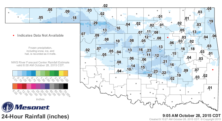
Northwest coast, at least. But it's also been raining in Oklahoma this morning.
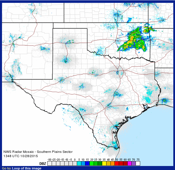

There is even a bit of thunder going on in Oklahoma. Amounts weren't heavy, but
hey, it's wet and we need wet!
So we may not know of the exact timing just yet, but we do know that Friday is
going to be a washout at least.

With rain continuing overnight and ending from west to east on Saturday.
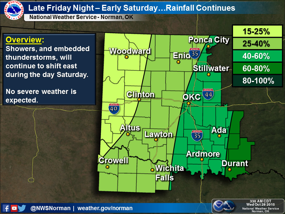
Amounts are looking fairly significant for this time of year, with as much as
2 inches or greater from SC through NE OK.
NWS-Norman is warning of an area of possible enhanced rainfall totals from
Wichita Falls through the OKC area, however, so this is something to be
watched.
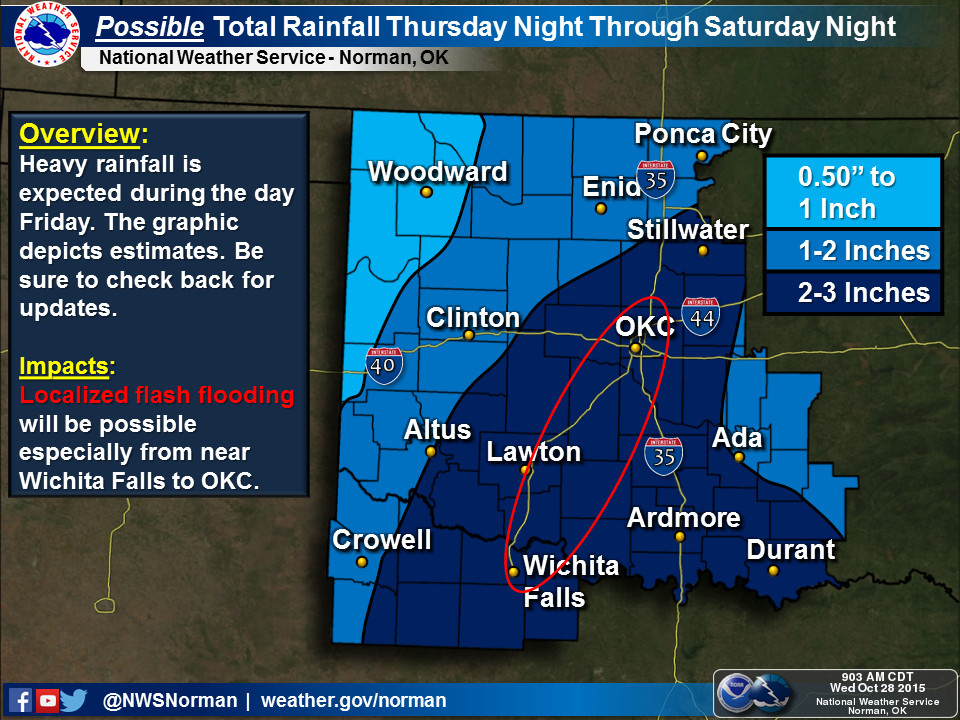
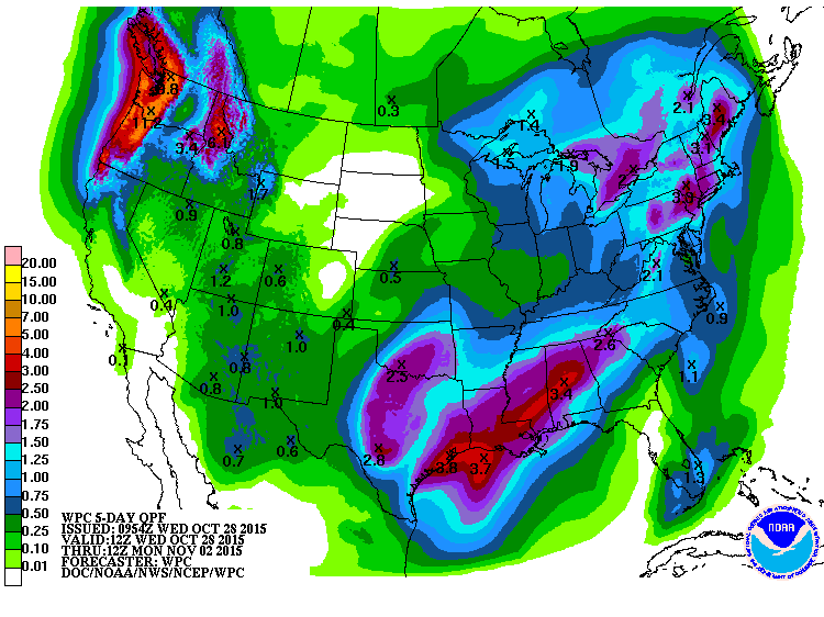
Their forecast discussion lays it out. There's a bit of technical language in
here, but what they're saying, in essence, is that there could be a river of
atmospheric water pouring our way on Friday along the low-level jet. This could
produce rainfall amounts as high as 4-5 inches if certain conditions materialize.
I'll leave out the gory parts, but here's the gist:
"FINALLY...WARM CLOUD DEPTH IS FORECAST TO BE GREATER THAN 10000
FT...WHICH WILL RESULT IN EFFICIENT WARM RAIN
PRECIPITATION PROCESSES. CURRENTLY EXPECTING AT LEAST 2-3 INCHES OF
RAIN ALONG THE I-44 CORRIDOR FROM WICHITA FALLS TO OKLAHOMA CITY.
HOWEVER...WOULD NOT BE SURPRISED TO SEE SOME 4-5 INCH TOTALS. A
FLASH FLOOD WATCH MIGHT BE NEEDED IN LATER FORECASTS."
Another little thing to worry about with the Friday night football and early
Halloween festivities on Saturday is the threat of lightning. The only thing
worse than soggy popcorn balls is electrified popcorn balls, so certainly
be weather aware this weekend.
I think at the least you're little trick or treaters might have a case of muddy
feet after they're done gathering their bounty. In eastern Oklahoma, you might
think about ponchos, and for everybody, it's gonna be just a bit chilly. If you
have the opportunity to go to some of those early trick or treating events at
schools and whatnot across eastern Oklahoma, my advice is to take advantage of
those. Otherwise, enjoy the rain.
Glenn sure wish he could!! Whoops, spoiler alert.
Gary McManus
State Climatologist
Oklahoma Mesonet
Oklahoma Climatological Survey
(405) 325-2253
gmcmanus@mesonet.org
October 28 in Mesonet History
| Record | Value | Station | Year |
|---|---|---|---|
| Maximum Temperature | 97°F | FREE | 2024 |
| Minimum Temperature | 18°F | BUFF | 2019 |
| Maximum Rainfall | 3.63 inches | STIG | 2025 |
Mesonet records begin in 1994.
Search by Date
If you're a bit off, don't worry, because just like horseshoes, “almost” counts on the Ticker website!