Ticker for October 26, 2015
MESONET TICKER ... MESONET TICKER ... MESONET TICKER ... MESONET TICKER ...
October 26, 2015 October 26, 2015 October 26, 2015 October 26, 2015
Call it...fall has arrived!

Before we start with our usual foolishness, we first need to reflect on what
happened at our sister institution this weekend. There are many rivalries
associated with the state's two largest schools, mostly sports related. But when
it comes to fellow Okies hurting, those rivalries disappear pretty quickly. And
many of you already know that while the Oklahoma Mesonet is housed in the NWC
on the campus of the University of Oklahoma at the Oklahoma Climatological
Survey, it is actually a project operated in full partnership with Oklahoma
State University. Three of the six Mesonet Steering Committee members are
affiliated with OSU (and three with OU), and many many faculty, staff and students
from there have helped make the Mesonet the world renowned network that is has
become. And the Mesonet was not immune to the impacts from this weekends horrible
and senseless tragedy.
"Dr. Marvin Stone and his wife Bonnie died Saturday during the tragic
Homecoming Parade event. Dr. Stone was a retired faculty member from
OSU's Biosystems and Agricultural Engineering department. He taught
courses for approximately 30 years and was a truly outstanding teacher,
researcher, advisor, colleague, and friend. He conducted research at
OSU in the areas of in automatic controls, sensor systems, and
electronic communication systems.
Dr. Stone was the Chair of our Mesonet Sensor Specification subcommittee
and co-authored one of the original Mesonet papers at OSU.
Elliott, R. L., F. V. Brock, M. L. Stone and S. L. Harp. 1994.
Configuration Decisions for an Automated Weather Station Network.
Applied Engineering in Agriculture 10(1):45-51.
Bonnie Stone was still working at OSU as a professional staff member
in Institutional Research and Information Management. They were
partners for life and great people, and it will be difficult to deal
with their loss.
We join with our OSU colleagues who knew them both well in offering our
condolences to their family and friends. Our thoughts and prayers go to the
OSU and Stillwater, and to the family and friends of those that lost their lives
or were injured. Regardless of where they hailed from, if they attended school
in Oklahoma, they were our fellow Okies.
-------------------------------------------------------------------------------
On with the weather, last week's rainstorm was called pretty well by the
forecasters,unless you live anywhere north of I40. The broad overview shows
the impacts from the large upper-level storm that moved across the Southern
Plains, the stalled cold front that helped generate further rainfall across the
SE, and also the path of the pacific hurricane Patricia that dumped even more
rain across Texas.
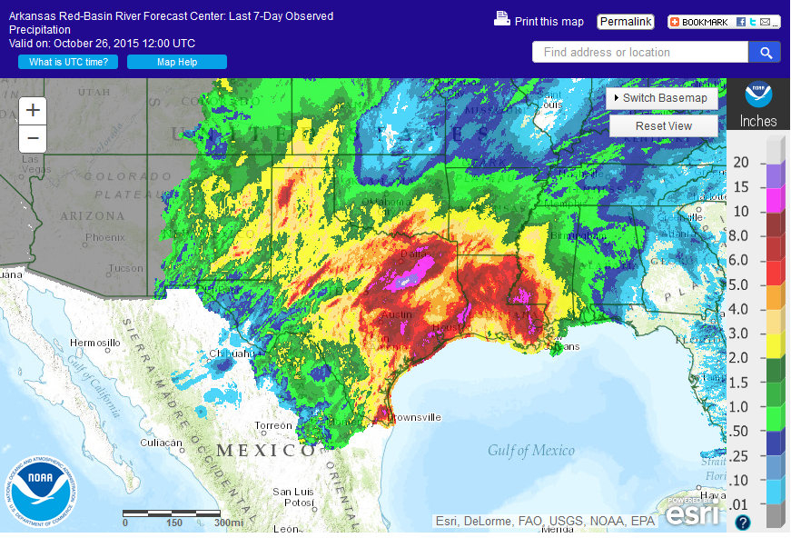
As far as the heavy rainfall, amounts across south central through SE OK paled
in comparison to some of those amounts in eastern Texas, where as much as 20"
of rain caused widespread flooding disasters. But as we get closer, we do see
drought-quenching rains across parts of S OK, as well as good rains in the
Panhandle and south of I40, generally.
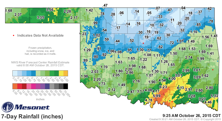
Tishomingo led the state with 6.23 inches, but Madill was close behind with
5.99 inches. Comparatively speaking, Hooker and Goodwell blasted both of those
amounts with 3.56 inches and 3.35 inches. Very rare rainfall totals for the
Panhandle indeed. Unfortunately, a lot of NC and NE Oklahoma went without
once again, registering less than a quarter-inch in a lot of places. That does
not bode well for that wheat crop that was dusted in, but maybe they'll get a
drink later this week.
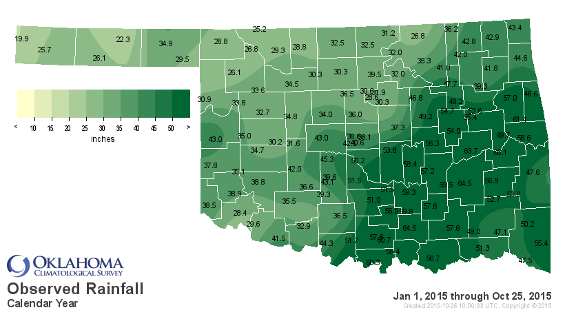
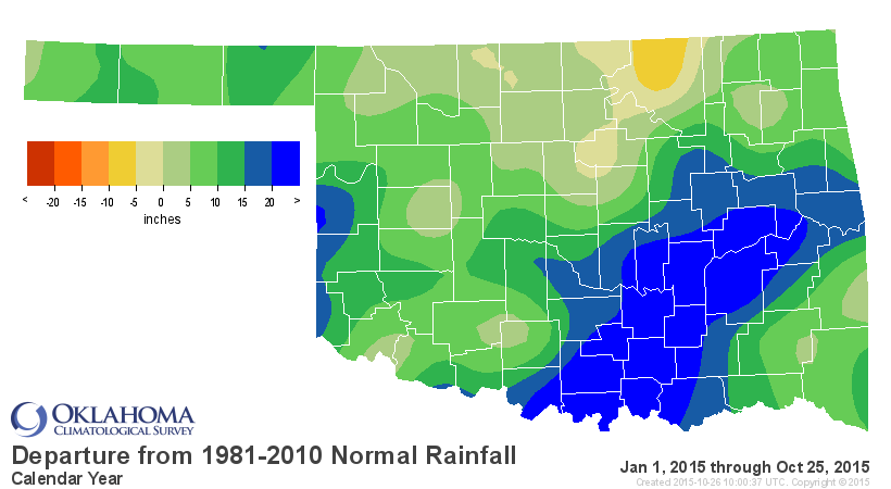
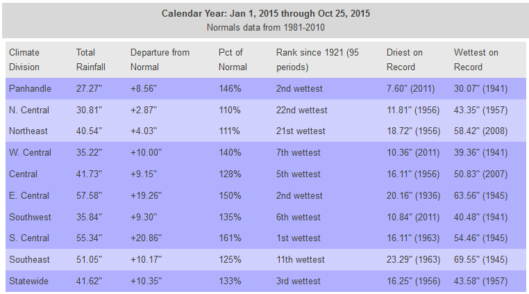
That rain across the S and the Panhandle have boosted us closer to 1957's record
annual pace, where we now sit with a statewide average for the year of 41.62
inches, 10.35 inches above normal and about 2 inches behind 1957's 43.58 inches
over that Jan 1-Oct 25 period. Remember, the calendar year record to beat is
1957's 47.88 inches, so we're only about 6 inches and some change away.
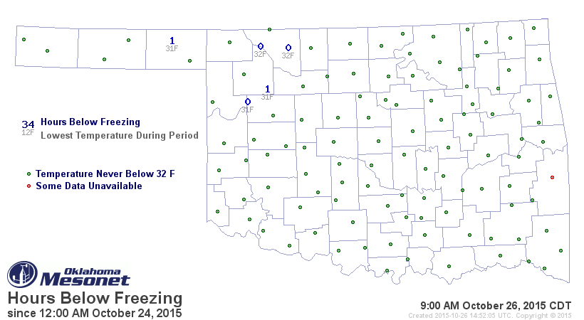
We also saw our first freeze of the season this weekend. Not a hard freeze, but
we saw several stations reach that 32 degrees mark and a little lower. That's
why even though it's about a week later than average, that first freeze tells us
we've probably REALLY hit fall. We've had some glimpses here and there, but
temperatures in the mid-80s as late as the 22nd kept us from feeling that
Autumny goodness.
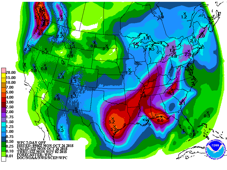
A front should pass through the state on Wednesday, but it has little cool air
to provide or even moisture. The bigger event will come late in the week and
possibly turn your popcorn balls to mush on Halloween. We'll know more from
the forecasters as the weekend draws near, but expect rain to start in the state
on Thursday but peaking on Friday and lingering into Saturday (Halloween Day).
This does appear a bit like the last system as far as the location of the
biggest totals, so northern Oklahoma should temper their expectations a bit.
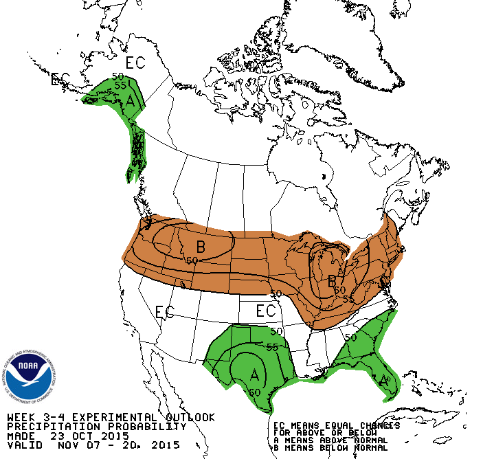
Still no sign of REALLY cold air yet, and I'm glad of it. But we do see the
influence of El Nino start to become more and more apparent (if it isn't already
so with last week's and this week's southerly diving storms. CPC's 3-4 week
outlooks show increased odds for above normal precip and below normal temps (at
least for the southern half of the state) for the 2nd two weeks in November.

Perhaps a moist Saturday morning will give way to a drier trick-or-treat period
later that day. Stay tuned to the forecasts for a fine-tuning there. And feel
free to send any soggy candy my way. I'm not picky.
Gary McManus
State Climatologist
Oklahoma Mesonet
Oklahoma Climatological Survey
(405) 325-2253
gmcmanus@mesonet.org
October 26 in Mesonet History
| Record | Value | Station | Year |
|---|---|---|---|
| Maximum Temperature | 93°F | MANG | 2014 |
| Minimum Temperature | 14°F | BOIS | 2020 |
| Maximum Rainfall | 3.78 inches | TISH | 2000 |
Mesonet records begin in 1994.
Search by Date
If you're a bit off, don't worry, because just like horseshoes, “almost” counts on the Ticker website!