Ticker for July 16, 2015
MESONET TICKER ... MESONET TICKER ... MESONET TICKER ... MESONET TICKER ...
July 16, 2015 July 16, 2015 July 16, 2015 July 16, 2015
Enough already!

So Mother Nature, or in this case, "Mommie Dearest," is determined to make our
lives miserable during July, just the way it's supposed to be. At least the heat
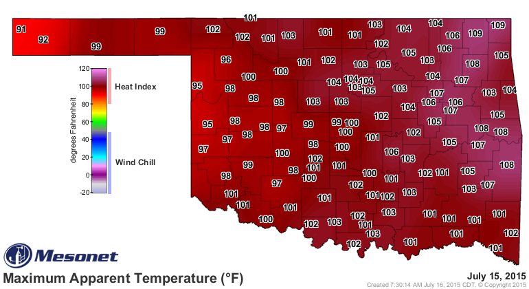
dome has shifted a bit to the east, but most of the state was still on fire
yesterday. But it's a moist heat, right? Yuck!
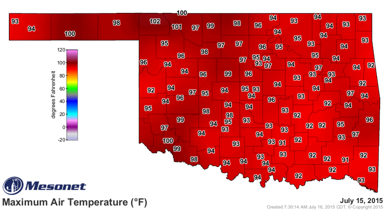
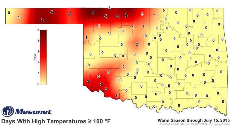
The days with highs at or above 100 degrees is at the most 5...at Buffalo of
course, the best place in the universe (even at or above 100 degrees). I don't
think this should come as a shock to you, but those 100-degree-days coincide
pretty well with the areas of least available soil moisture near the surface.
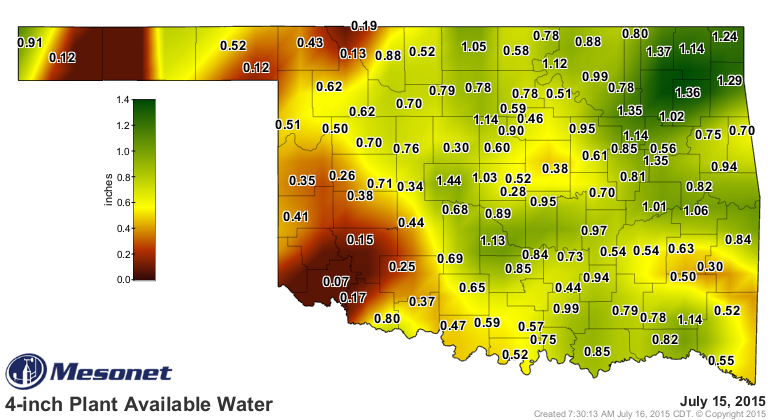
Those areas are where the sun has enough dry soil, plowed wheat fields and drier
air to bump up those air temperatures. It ain't over yet. We might have a chance
for showers and storms as the edges of that heat dome erode a bit as it moves
to the south. With that and the drying of the soils over the last week, the
heat indices and the temperatures themselves should come down a bit...but make
no mistake about it, it will still be hot.
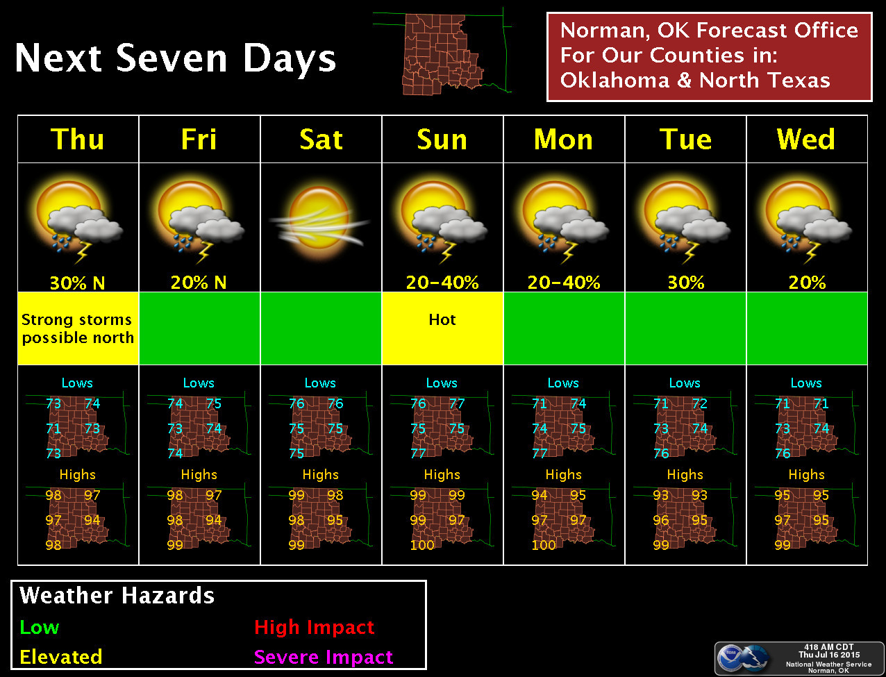
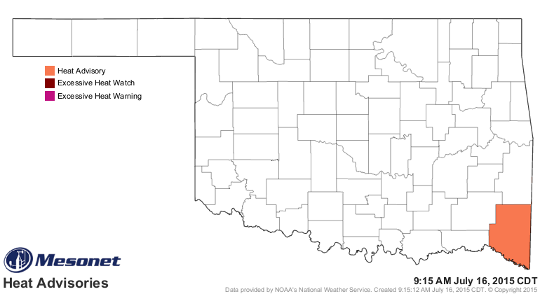
But no heat advisories save for McCurtain County.
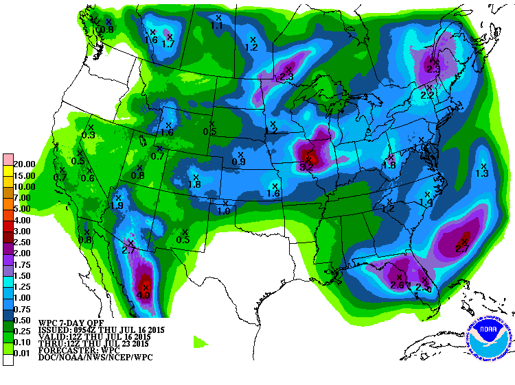
The moisture should skirt the fringes of the heat dome for the most part, so
the Panhandle (which is actually in the middle of its rainy season) and far
northern Oklahoma should get the greatest moisture totals.
Whatever falls will just end up in the air and a higher mark on the heat index
map, but at least it will be cool as it falls. Now how about looking a bit
farther into the future. CPC is still showing increased odds of below normal
temperatures and above normal precipitation, especially for northern OK, for
the August and also August-October periods.
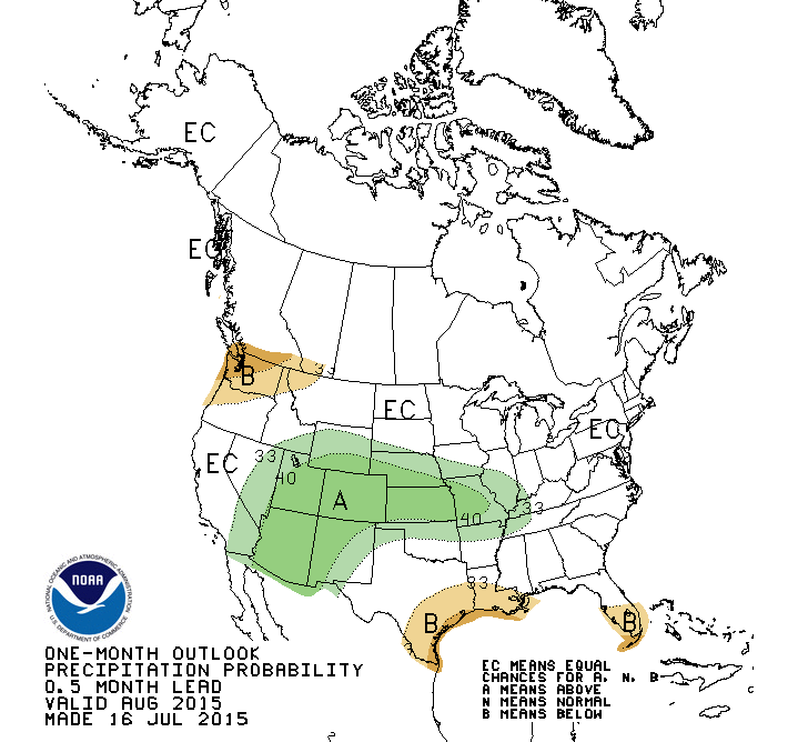
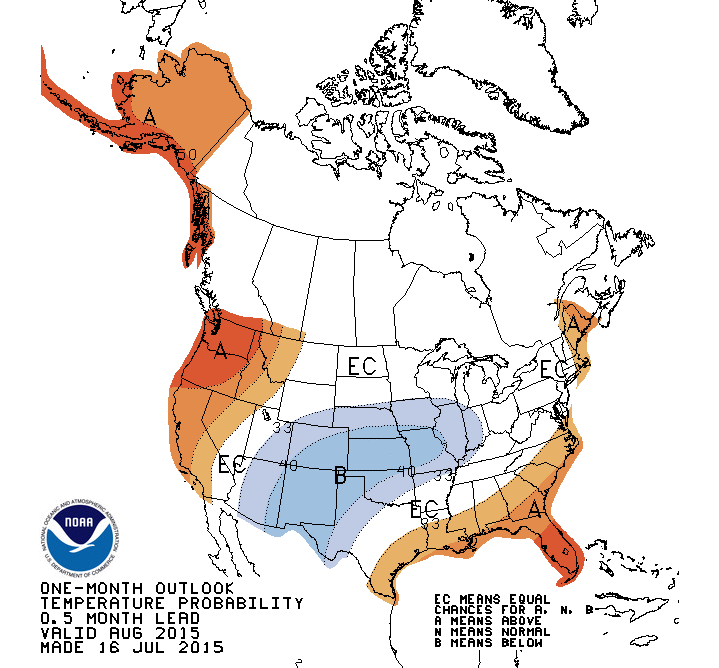
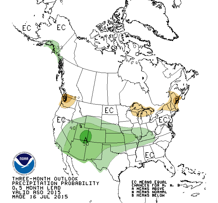
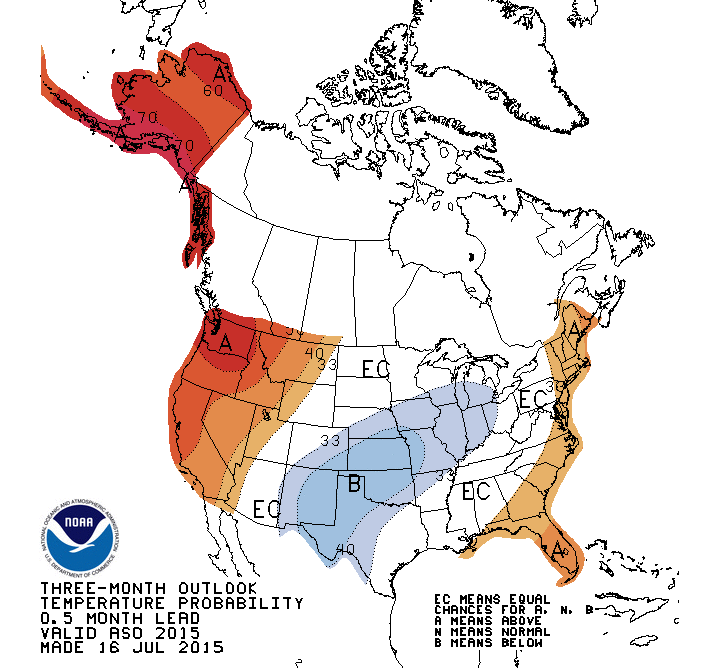
The reasoning from the CPC forecasters is pretty sound, and has worked out for
the most part over the last month or so (even though it is a bit hotter than
their outlook indicated, it's probably cooler than what it would have been
without the moist soils and rainfall). Their reasoning for the August and August-
October periods are:
1) Moist soils holding maximum temperatures down a bit.
2) El Nino, which is getting stronger by the month and expected to continue to
do so, will be having the expected impact for our area (i.e., cooler and wetter
than normal weather). The farther into fall we get to, the more important the
impacts of El Nino become. That was very Yoda-like, but get the picture you do.
3) Increased pacific tropical storm activity, normal for an El Nino event,
could continue to provide enhanced rain chances for the Southwest U.S., and
possibly over our area.
This wet, cool pattern, typical of El Nino, could continue all the way through
next winter. Here's the reasoning from the forecasters (I've translated a bit,
and they're screaming at you, not me):
"AS THE FORECASTS PROGRESS INTO THE AUTUMN, THE PATTERN SLOWLY
MORPHS TO ONE CONSISTENT WITH MODERATE TO STRONG EL NINO CONDITIONS,
LARGELY FAVORING BELOW NORMAL TEMPERATURES ACROSS THE SOUTH-CENTRAL
AND SOUTHEAST U.S., WITH ABOVE NORMAL TEMPERATURES ACROSS THE
NORTHERN TIER. PROBABILITIES OF BELOW NORMAL TEMPERATURES ACROSS THE
SOUTHERN GREAT PLAINS ARE HIGHEST IN FEB-APRIL 2016."
"THE FORECAST ROBUST EL NINO CONDITIONS ARE EXPECTED TO YIELD
SIGNIFICANT PRECIPITATION IMPACTS FROM AUTUMN 2015 TO SPRING 2016.
THUS THE CHANCES FOR ABOVE-MEDIAN PRECIPITATION ARE ELEVATED
THROUGHOUT THE SOUTHERN U.S. FROM SEPT-NOV 2015 - FEB-APR 2016."
So for those reasons, no drought is expected to develop in Oklahoma through
the end of October. That doesn't mean a flash drought situation is impossible
as we go through the next couple of months, but we're positioned pretty well.
Most of the time these CPC outlooks are "read at your own risk," but do
understand their confidence does go up in the presence of a strong ENSO signal,
such as El Nino or La Nina. And this El Nino is fairly significant and appears
to be more significant as we go through the rest of the year into early spring
2016.
Now break out the wire hangers and let's see what happens.
Gary McManus
State Climatologist
Oklahoma Mesonet
Oklahoma Climatological Survey
(405) 325-2253
gmcmanus@mesonet.org
July 16 in Mesonet History
| Record | Value | Station | Year |
|---|---|---|---|
| Maximum Temperature | 109°F | HOLL | 2001 |
| Minimum Temperature | 51°F | JAYX | 2014 |
| Maximum Rainfall | 3.82″ | ALTU | 2014 |
Mesonet records begin in 1994.
Search by Date
If you're a bit off, don't worry, because just like horseshoes, “almost” counts on the Ticker website!