Ticker for December 5, 2014
MESONET TICKER ... MESONET TICKER ... MESONET TICKER ... MESONET TICKER ...
December 5, 2014 December 5, 2014 December 5, 2014 December 5, 2014
Because you know I'm all about that heat
'bout that heat, no treble.
Old folks, don't bother. Just keep it on KOMA listening to "Witchy Woman." Some
have said my Tickers have shown I have a one drought mind, and rightfully so. I
do tend to concentrate on the most current multi-billion dollar disaster. But
a little-known fact about my Irish-American roots -- "McManus" means "he who
hates cold weather." So I'm going to talk about this coming "heat wave" until
it actually happens.
For you see, it tasks me. It tasks me and I shall have it! I'll chase it 'round
the moons of Nibia and 'round the Antares Maelstrom and 'round perdition's flames
before I give it up!
Whoa, sorry for going all Khan there, but I'm still ?ber-excited about the 6-10
and 8-14 day outlooks I'm seeing from the CPC. And not only for the heat, but
also for moisture chances as well.
Dec. 10-14 outlooks
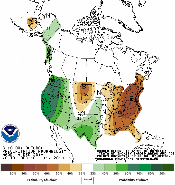
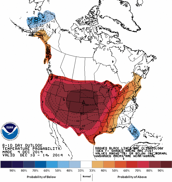
Dec. 12-18 outlooks
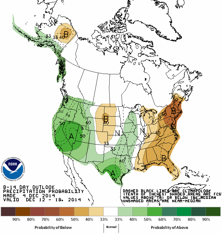
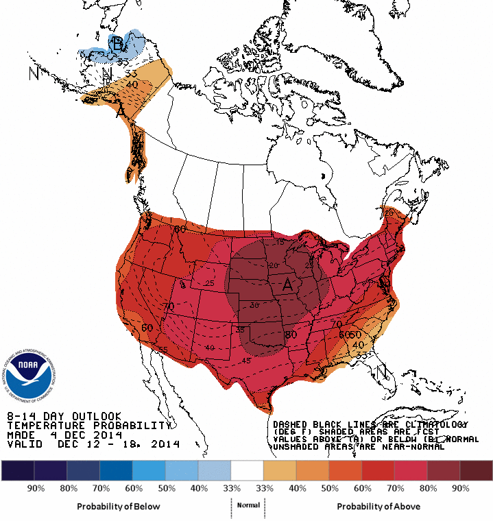
Again, these are just probabilities of above-, below- or near-normal temperatures
and precip, but to me, they say a deliciously warm December with an added chance
of moisture. But what does it really mean? We're talking temperature averages
here, so will it be highs in the 60s, maybe? Lows only dropping into the 40s?
Both? Some 70s here and there? The anticipation! It's almost like waiting for
a Christmas gift.
Speaking of Christmas and the rest of the holiday season, this is not a death
knell for those that like cold weather. You know if that jet stream is stuck
in a zonal west-to-east pattern, there will be a kink somewhere that could
eventually make its way around to our part of the world. Lots of things can
change the coming pattern around (and it still has to come to fruition in the
first place). Remember the big story in mid-November was how former SUPER-
TYPHOON Nuri camped out in the Bering Sea, deepened into one of the most
powerful extra-tropical storm systems on record, and changed the air flow
patterns across the Northern Hemisphere. That series of events brought us our
big blanket of snow AND the coldest 7-day period for November on record. And it
just so happens there is another Super-Typhoon (Hagupit) roaming around the
Philippines area. I'm not saying it's gonna pull a Nuri on us, but Hagupit
was doubtful to even hit the Philippines a few days ago and now it looks like
it will go right over its center.
In other words, that's how fast things (i.e., forecasts/outlooks) can change.
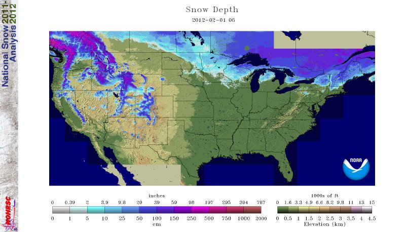
Let's also not forget the winter of 2011-12 in which that zonal pattern stayed
throughout the season and kept all the arctic air bottled up north and much of
the contiguous U.S. experienced a winter without snow (as evidenced by this
snow cover map from Feb. 1, 2012).
Not much else to say after all that vagueness and backtracking on forecasts and
outlooks. We can only anticipate what's going to happen given the best available
science, and it looks like we're gonna turn mild for awhile during December. But
Mother Nature will do what she wants, regardless of our computer models.
Just a bit of heat, please. That's good enough for me.
Gary McManus
State Climatologist
Oklahoma Mesonet
Oklahoma Climatological Survey
(405) 325-2253
gmcmanus@mesonet.org
December 5 in Mesonet History
| Record | Value | Station | Year |
|---|---|---|---|
| Maximum Temperature | 84°F | MANG | 2021 |
| Minimum Temperature | 0°F | KENT | 2013 |
| Maximum Rainfall | 1.55″ | BIXB | 2021 |
Mesonet records begin in 1994.
Search by Date
If you're a bit off, don't worry, because just like horseshoes, “almost” counts on the Ticker website!