Ticker for December 4, 2014
MESONET TICKER ... MESONET TICKER ... MESONET TICKER ... MESONET TICKER ...
December 4, 2014 December 4, 2014 December 4, 2014 December 4, 2014
Drought, fog, rain, El Nino...take your pick
This surge of relatively warm (and moist) air that has moved over the state
has generated a great deal of fog, enough so that we have widespread dense fog
advisories over the Southern Plains region.
The moisture is wonderful, but it is wreaking havoc on my hair. The one on the
right...the one on the left seems unaffected.
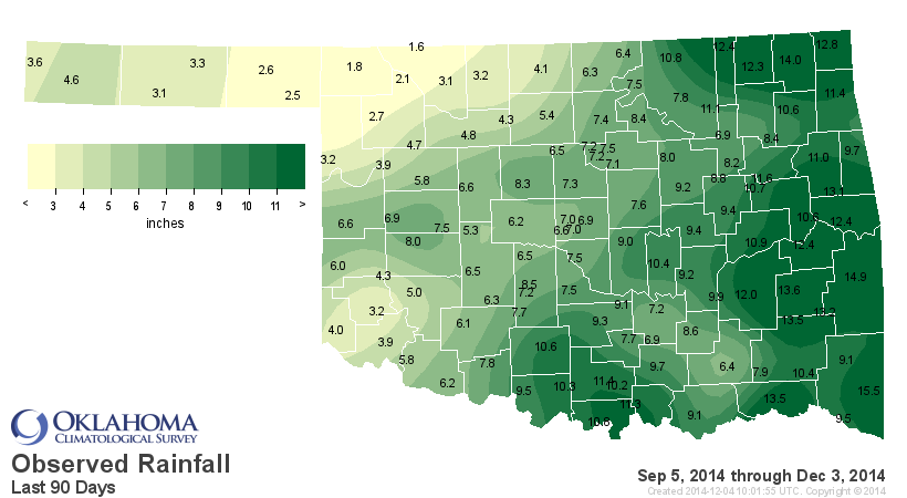
We have to talk drought since the new map came out this morning. We started to ask
for some intensification across NW Oklahoma where the rains have generally stayed
away for the most part (as evidenced by the following maps):

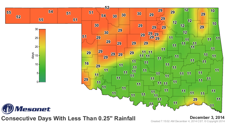
We decided to stay the course for the most part for one more week, given that it
cooled down considerably and there is at least a hint of appreciable moisture in
that area (I'll believe it when I see it on the Mesonet map).
There was a bit of an intensification down across south central Oklahoma where
moderate drought was introduced into Marshall and Bryan counties.

So the amount of the state in drought jumped slightly from 59.85% to 60.29%.
I'll go ahead and say if we don't see good rains in the NW, that figure is likely
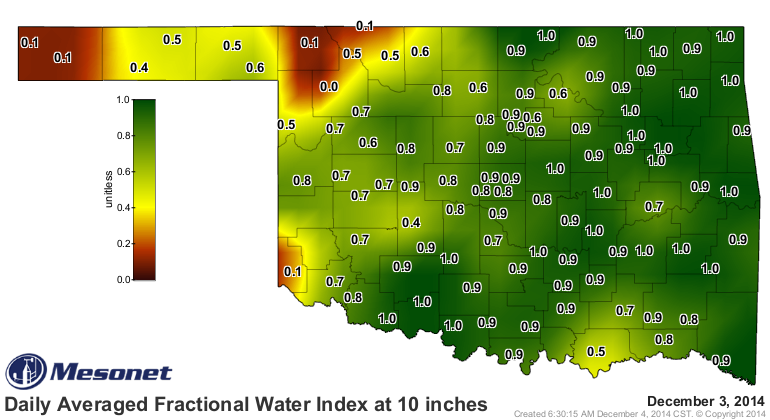
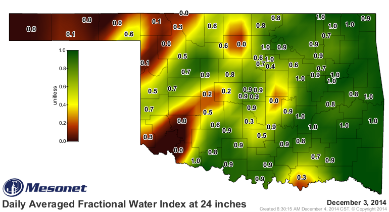
to jump next week as well. The 10-inch and 24-inch soil moisture values from
the Mesonet show soil columns dry as a bone down to at least 2 feet.
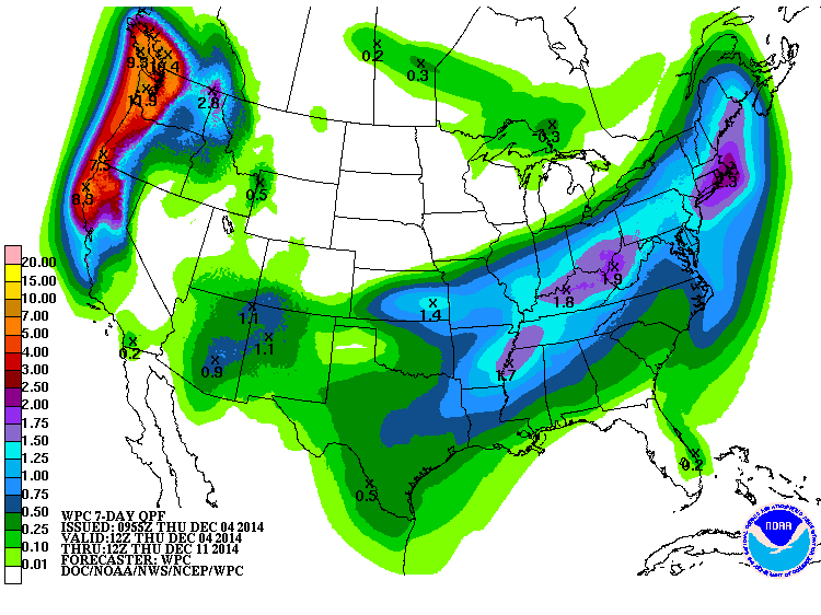
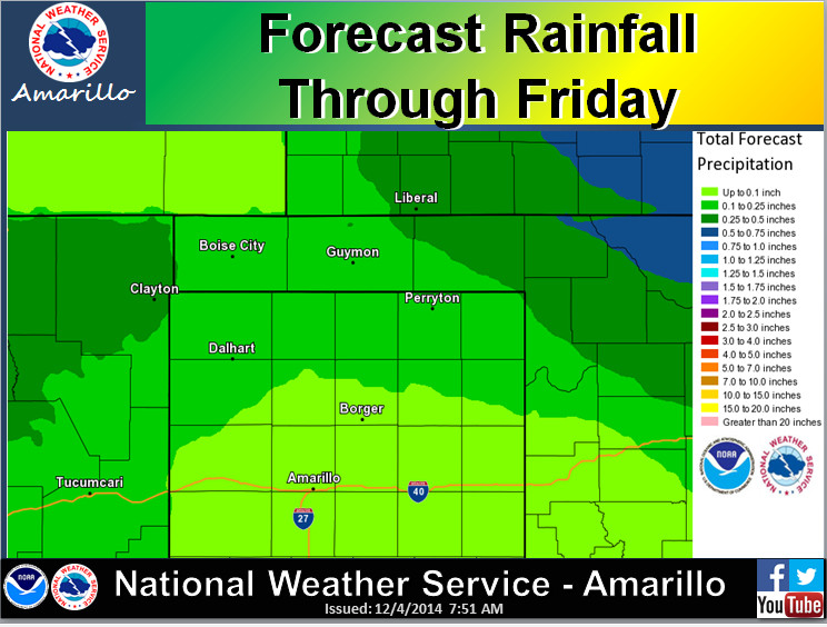
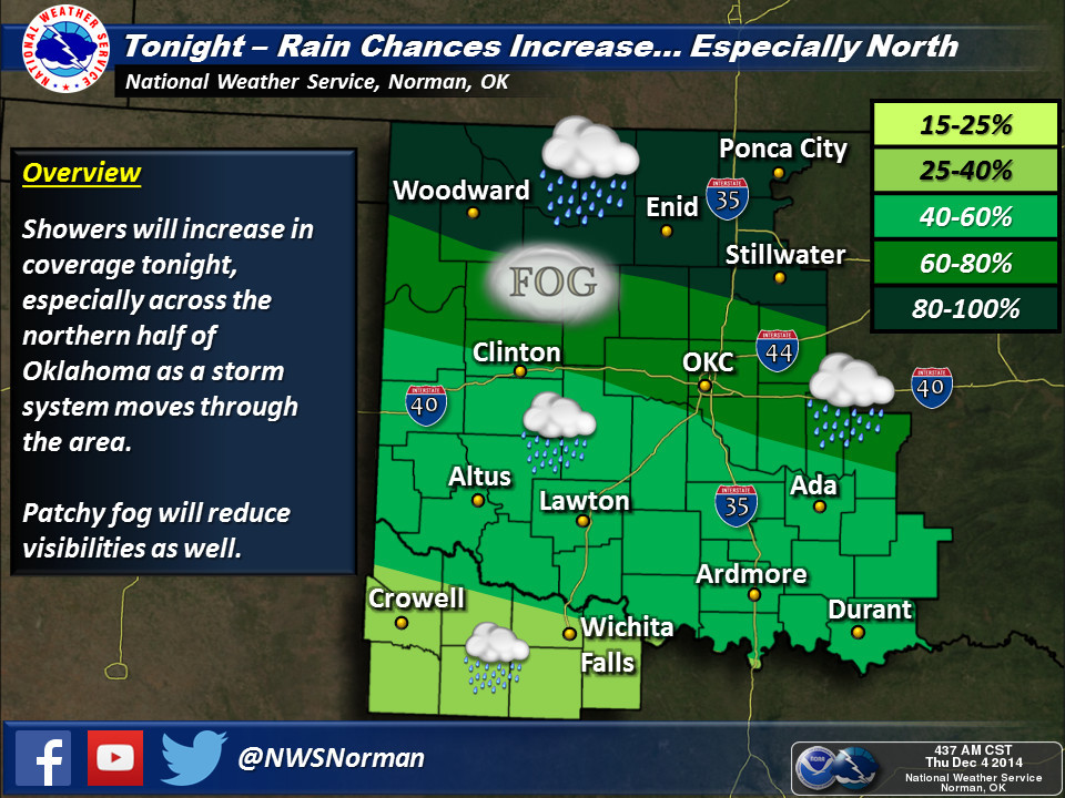
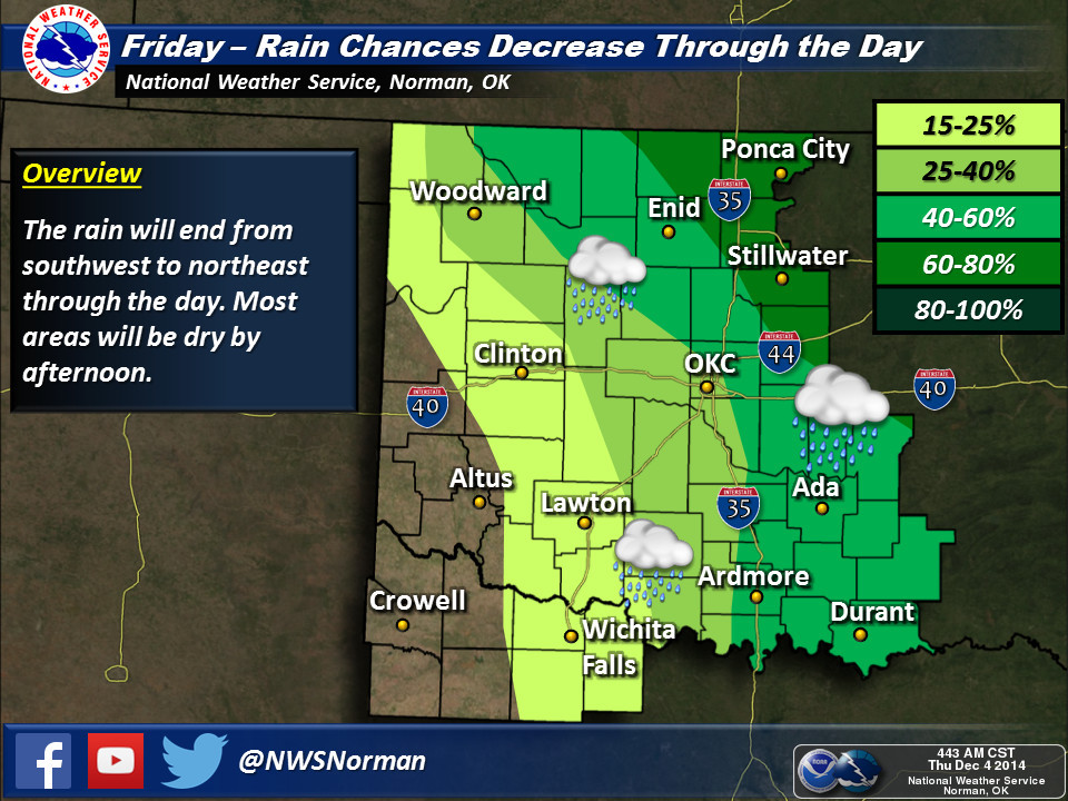
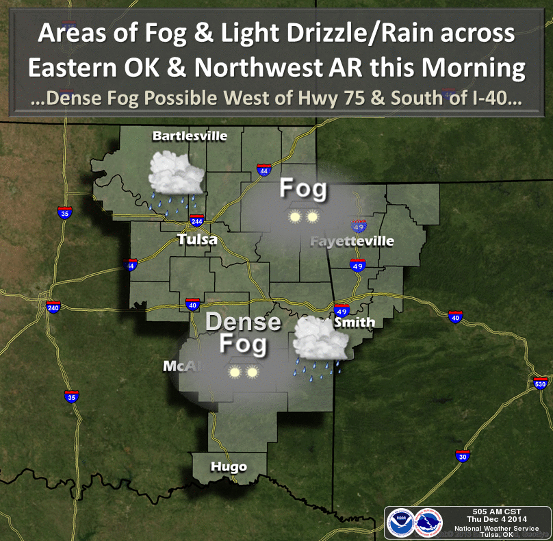
We do have the aforementioned rain in the forecast, with the good stuff starting
tonight apparently. Our friends at the NWS offices give us the scoop. Norman
talks timing, Tulsa talks fog and Amarillo talks amounts. That's about all you
need right there.

The call for warmer weather is still being made by CPC in their 6-10 and 8-14
day outlooks. It seems like a long ways away, especially with the below normal
weather we've been having. But maybe by the end of next week, we'll start to
see some of those nicer days ahead. One of the best explanations I've seen
comes from famed WGN meteorologist Tom Skilling. While he's mostly focused on
Chicago, his graphics tell the overall story quite nicely. Here you can see
on the right side of his graphic a shift from some "back door" cold fronts
(i.e., from the northeast) into our region this weekend and early next week to
a more zonal (west-to-east) jet stream pattern after that which will usher in
the warmer, pacific air.
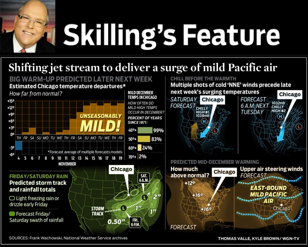
His predicted warming is from 12-16 degrees above normal for mid-December,
meaning highs in the mid-60s for our parts (dare I say approaching 70??). So we
do have a few cold intrusions to go before that jet stream flattens out and traps
that cold arctic air up north.
And last but not least, the new CPC ENSO (El Nino/Southern Oscillation)
bulletin came out this morning and the odds of El Nino forming this winter are
back up to 65%. The sea surface temperatures appear to be game, but the
associated atmospheric changes are not playing along, preventing an official
El Nino event being declared:
" Although the SST anomalies alone might imply weak El Ni?o
conditions, the patterns of wind and rainfall anomalies
generally do not clearly indicate a coupling of the atmosphere
to the ocean. Therefore, despite movement toward El Ni?o from
one month ago, the combined atmospheric and oceanic state remains
ENSO-neutral. Similar to last month, most models predict SST
anomalies to be at weak El Ni?o levels during November-January
2014-15 and to continue above the El Ni?o threshold into early
2015. Assuming that El Ni?o fully emerges, the forecaster consensus
favors a weak event.
In summary, there is an approximately 65% chance of El Ni?o
conditions during the Northern Hemisphere winter, which are
expected to last into the Northern Hemisphere spring 2015..."
First, it'd better hurry or it's going to Northern Hemisphere spring already,
and second, it's still our contention that a weak El Nino event is not good
news for Oklahoma. When we do see weak El Ninos, conditions across the state
tend to be drier than normal the majority of the time (at least during the
cool season through March). Now ENSO is not the only phenomenon that guides
our weather. At best, it can explain about 30% of our persistent weather
patterns (according to some research). So whether El Nino forms or not, we
still have other factors that could bring us some good rains.
Santa Clause, for instance. Rain should be on everybody's wish list.
Gary McManus
State Climatologist
Oklahoma Mesonet
Oklahoma Climatological Survey
(405) 325-2253
gmcmanus@mesonet.org
December 4 in Mesonet History
| Record | Value | Station | Year |
|---|---|---|---|
| Maximum Temperature | 83°F | BURN | 2017 |
| Minimum Temperature | -2°F | NOWA | 2006 |
| Maximum Rainfall | 2.44 inches | MIAM | 1999 |
Mesonet records begin in 1994.
Search by Date
If you're a bit off, don't worry, because just like horseshoes, “almost” counts on the Ticker website!