Ticker for November 20, 2014
MESONET TICKER ... MESONET TICKER ... MESONET TICKER ... MESONET TICKER ...
November 20, 2014 November 20, 2014 November 20, 2014 November 20, 2014
WHO LIKES KITTENS???
I've learned not to bury the lead, so if you live in the, say...southeastern half
of the state, SE from about Waurika to Foraker, then check out this map. If you
live to the NW of there, especially if'n you're from the Panhandle and parts
NW, skip down to the second picture.
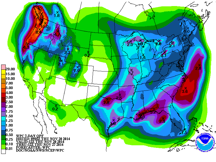
Wow, quite a nice storm system for this weekend, no?
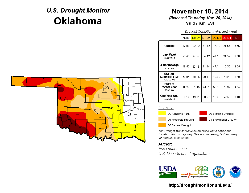
Now, for you NW-half of the state folks, here's a picture to make you feel
better.

Sorry NW-halfers, that's about as good as I can do. At least you got a bit of
snow and moisture last weekend. But this coming storm does not look good for you.
Given the drought picture released this morning from the U.S. Drought Monitor
folks, that is bad news indeed.
The coming storm will be good news for SE OK, where you see lots more yellow
(and I'm not talking leaves) on this week's map. All the drought categories
(D1-D4) stayed the same, but the D0/Abnormally Dry designation (remember, it is
not a drought category) increased from 77.6% to 82.1%. And obviously we still
have large areas of western Oklahoma mired in severe-exceptional drought. And
those are the areas that will probably not see much moisture this round.
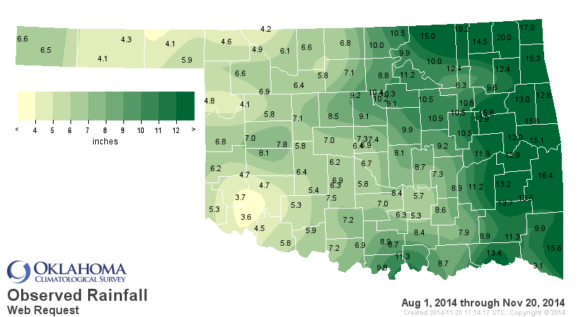
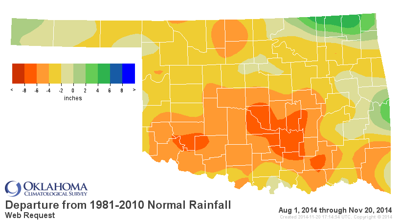
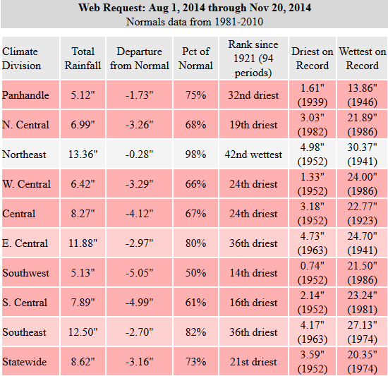
This is what we're working with as far as drought goes since August 1. As you
can see, we're not doing well in the long-term.
We also saw the winter forecast from the Climate Prediction Center released
this morning, and it is somewhat favorable for Oklahoma. We'll start with
just the December outlooks, however, which indicate increased odds of below
normal temperatures and above normal precipitation for most of the state.
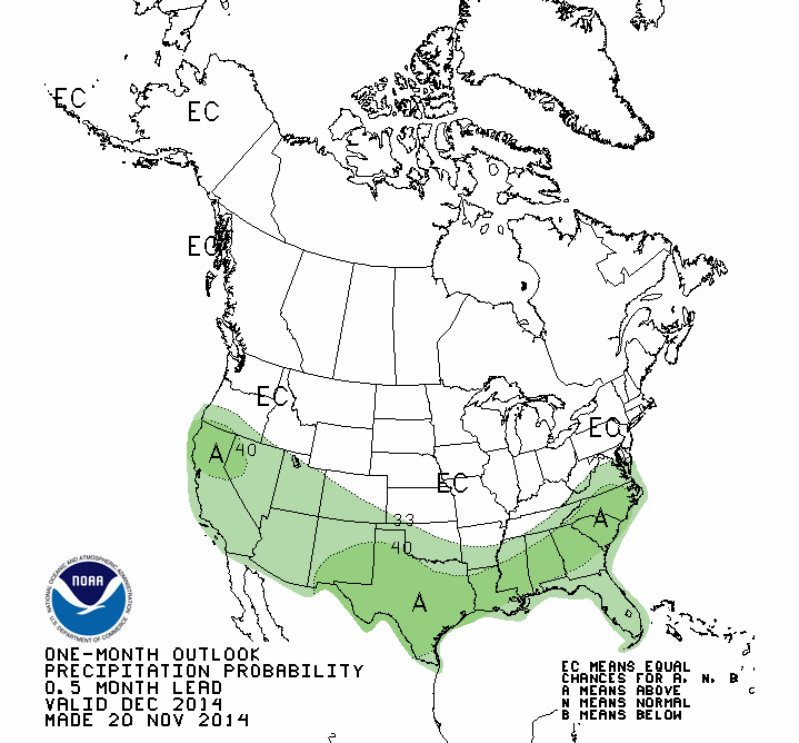

Let me warn you, the combination of those two is not an forecast for more snow
and/or ice. It simply means that the forecasters are betting a bit more on the
average temperatures to be cooler during the month whilst also coinciding with
another small bet on increased moisture. Keep this in mind, also...December
is one of our driest months of the year, so we're not exactly talking a wet
May here. But, it is a bit of hope.
As for the December-February period, this is class El Nino response mostly,
so definitely take these with a grain of salt. El Nino actually has to get
kickin' before we can see this robust of a response.
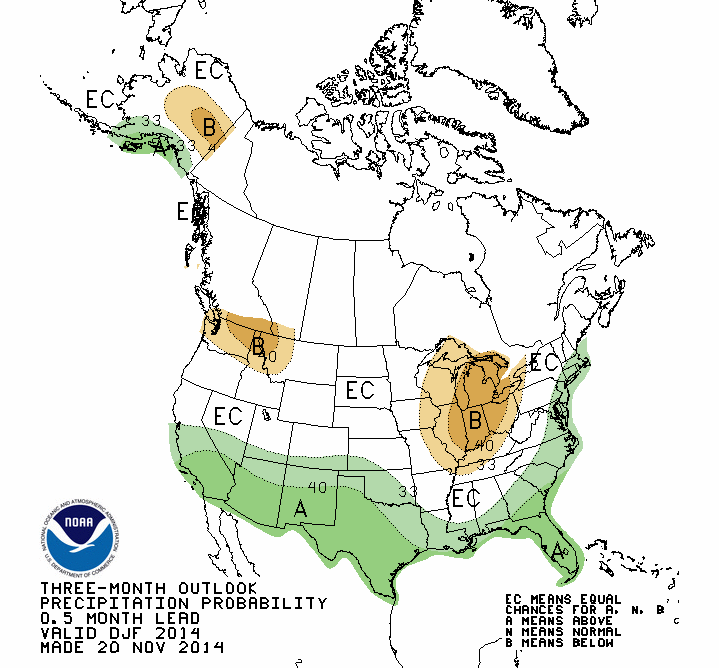
Again, let me warn you, THIS SHOULD NOT BE INTERPRETED AS A STRONG SIGNAL FOR
LOTS OF SNOW AND/OR ICE! It's a bet by the forecasters that we'll see above
average precip and (a bit of a stronger bet) below normal temperatures. Trust me
(HA!), I know how tempting it is to parlay those two into "IT'S GONNA SNOW A
LOT THIS WINTER" forecasts, but that's not what these products are meant
to show. And again, El Nino is still just a suspect as of now, no indictments
handed down.
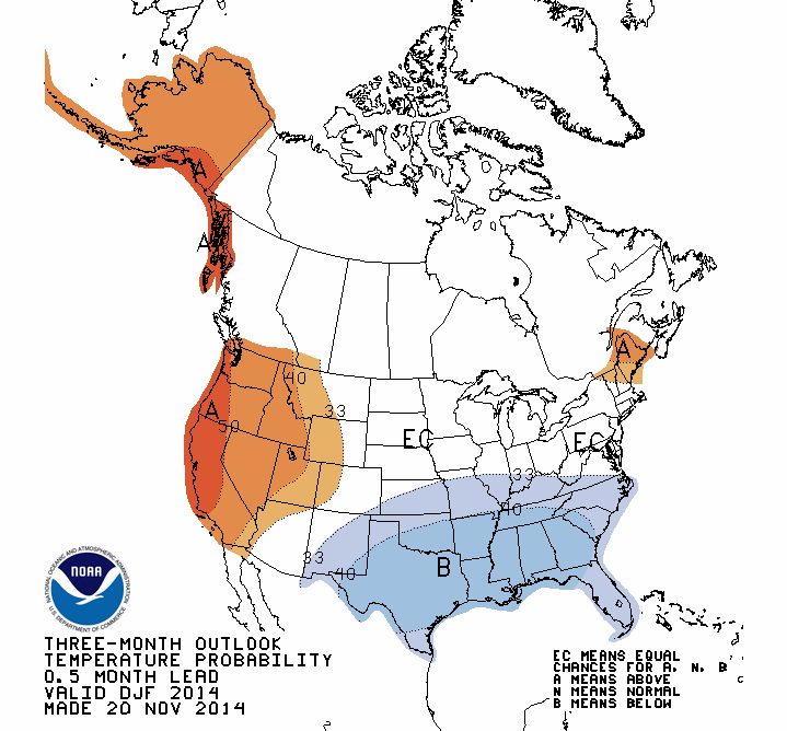
There is something interesting in that temperature map, however. Notice how
the increased odds of below normal temps extends farther to the east and north?
Definitely outside the scope of an El Nino signal? Well, that's coming off
lots of recent research about early snowpacks in places like Siberia and other
scenic destinations changing the large-scale airflow across the northern
hemisphere. The CPC forecasters mention this in their discussions, and also
bring our old friends the Arctic Oscillation (AO) and North Atlantic Oscillation
(NAO) into play:
"GIVEN THE EXPECTED WEAK NATURE OF THIS EL NINO, THE WARMER SOLUTIONS
AMONG THE TOOLS WERE LARGELY DISCOUNTED. SNOW COVER THROUGHOUT
THE NORTHERN HEMISPHERE WAS WELL ABOVE THE LONG-TERM NORMALS IN
OCTOBER, AND SOME RECENT RESEARCH SUGGESTS THAT THIS MAY INCREASE
LIKELIHOOD OF BELOW-NORMAL TEMPERATURES IN EASTERN NORTH AMERICA. THE
CA-SST TOOL SUGGESTS A NEGATIVE AO/NAO WHICH IS ALSO ASSOCIATED WITH
BELOW-NORMAL TEMPERATURES IN THE EASTERN CONUS. CONSIDERING THESE
FACTORS, THE REGION FAVORING BELOW-NORMAL TEMPERATURES WAS EXPANDED
SOMEWHAT FROM WHAT WAS INDICATED ON LAST MONTH'S OUTLOOK..."
What that says to me is another winter like last year where we had lots of cold
air incursions from the north into the eastern half of the U.S. and the west
being left under lots of ridges of high pressure (i.e., warm). As for the
precipitation forecasts, I'm just not sold on those given the at-best weak
nature of the El Nino still forecast to form.
Now, after all of that discussion, what do we see as a U.S. Seasonal Drought
Outlook from CPC? Well, just keep in mind that we're in our driest time of the
year, so it ain't good. This map is good (or bad) for today through the end
of February.
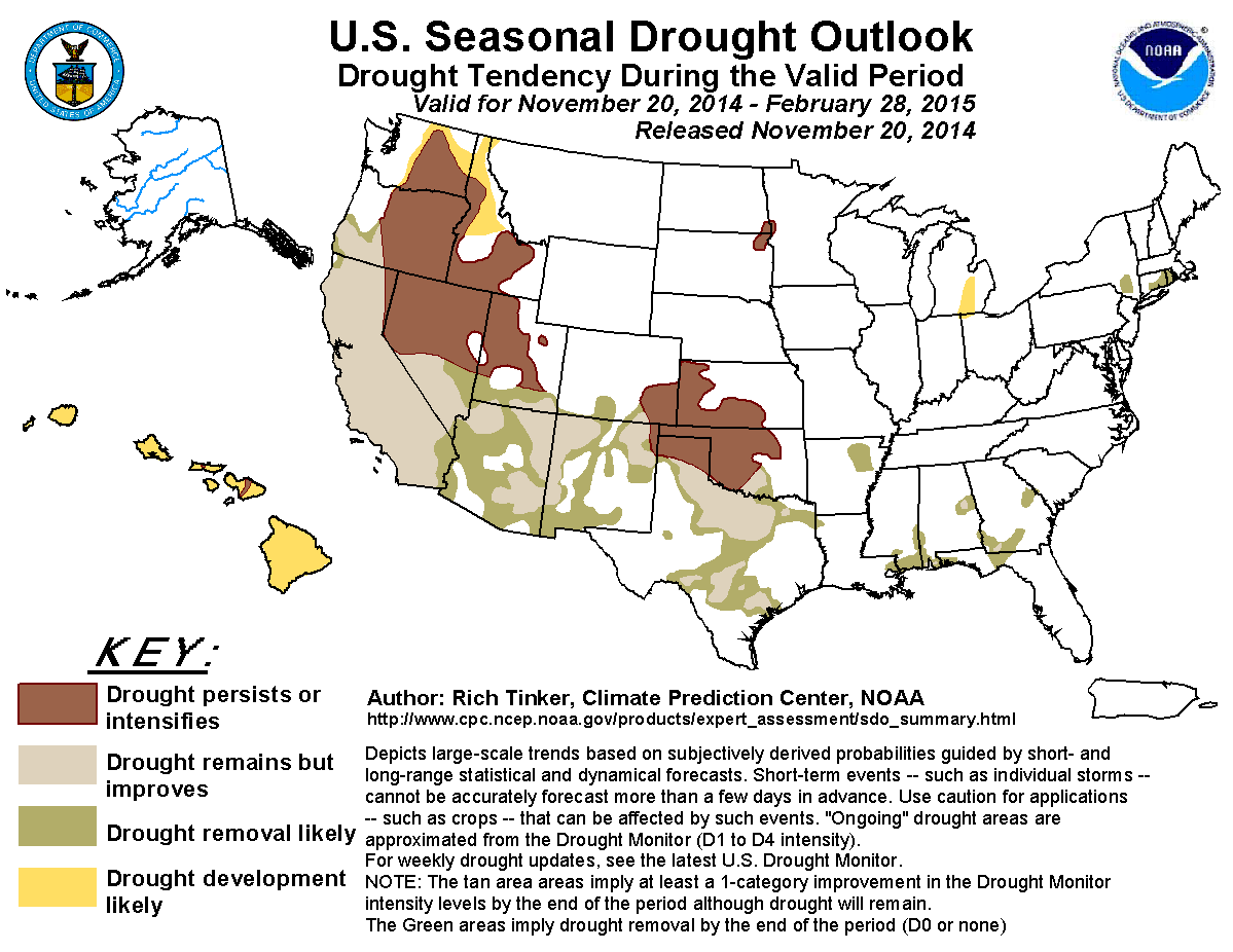
That bit of improvement/removal across south central Oklahoma is no doubt due
to the coming storm system, but persistence and intensification is indicated
across the rest of Oklahoma's drought area.
Well heck, I hate to end the Ticker on such a sour note. Take this one with
ya instead.

Gary McManus
State Climatologist
Oklahoma Mesonet
Oklahoma Climatological Survey
(405) 325-2253
gmcmanus@mesonet.org
November 20 in Mesonet History
| Record | Value | Station | Year |
|---|---|---|---|
| Maximum Temperature | 85°F | ARNE | 2007 |
| Minimum Temperature | 11°F | BEAV | 2022 |
| Maximum Rainfall | 4.05 inches | SMIT | 2025 |
Mesonet records begin in 1994.
Search by Date
If you're a bit off, don't worry, because just like horseshoes, “almost” counts on the Ticker website!