Ticker for October 16, 2014
MESONET TICKER ... MESONET TICKER ... MESONET TICKER ... MESONET TICKER ...
October 16, 2014 October 16, 2014 October 16, 2014 October 16, 2014
Drought takes a beatin'...
but keeps on tick(er)ing. We don't have much time to tick today, so enough tock
(get it?). Let's go right to the newest U.S. Drought Monitor map released this
morning.
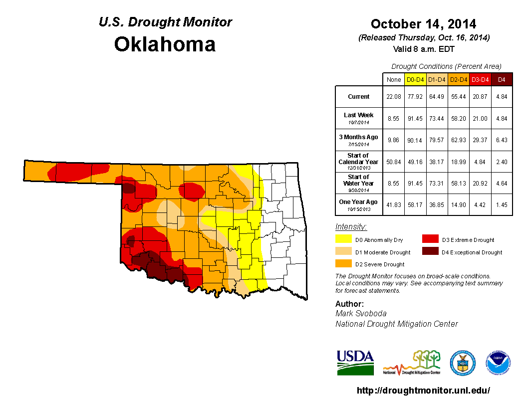
Pay attention to the right side of the map, and of the figure. The eastern third
of the state is mostly out of drought as of Tuesday according to the Monitor,
with a slice of that area still in the "abnormally dry" or D0 category. There
is a bit of a jigsaw piece in there with drought extending over into Osage and
Tulsa counties but another piece extending to the west into Oklahoma and Logan
counties. In all, the amount of the state in drought (at least D1) dropped a
whopping 9% in one week, and the amount in at least Abnormally Dry conditions
dropped about 13%. For the Drought Monitor, that is a substantial reduction for
one week.
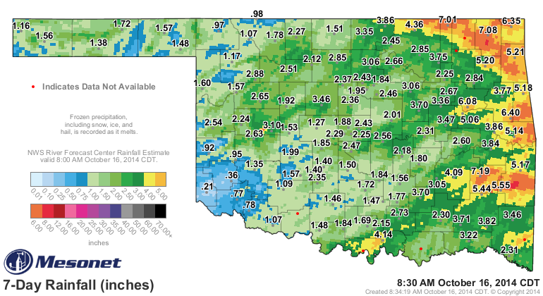
We have the rains from last Thursday-Monday to thank, of course, and it still
shows up on the Mesonet's 7-day rainfall map.
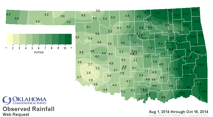
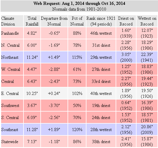
The reason we are still in drought? Well, there are still substantial deficits
both in the short term and long term. For the short(er) term, let's take a look
at the rainfall since August 1, the period when our lovely summer rains came
to an end. Only a 1.18" deficit since Aug. 1st statewide, but that's colored
by the moisture from eastern Oklahoma. Western Oklahoma even over to central
Oklahoma does not share in that bounty.
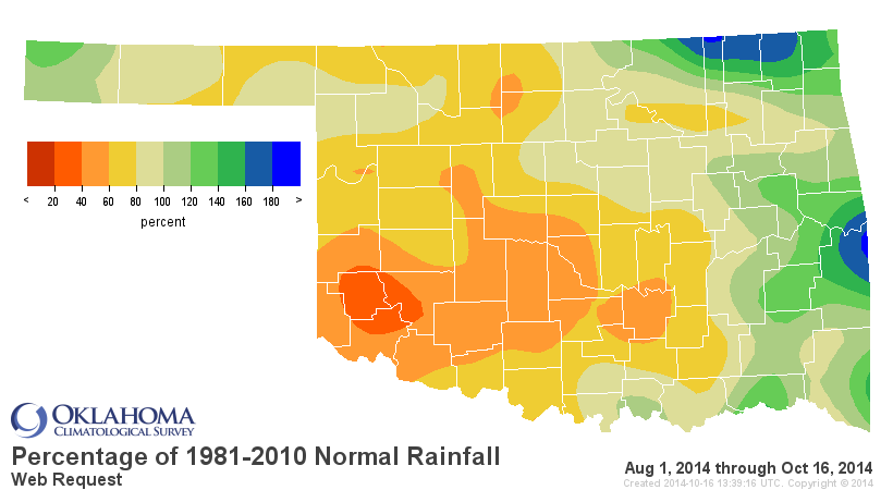
Go all the way back to the beginning of the year and the deficits really jump
out at ya.


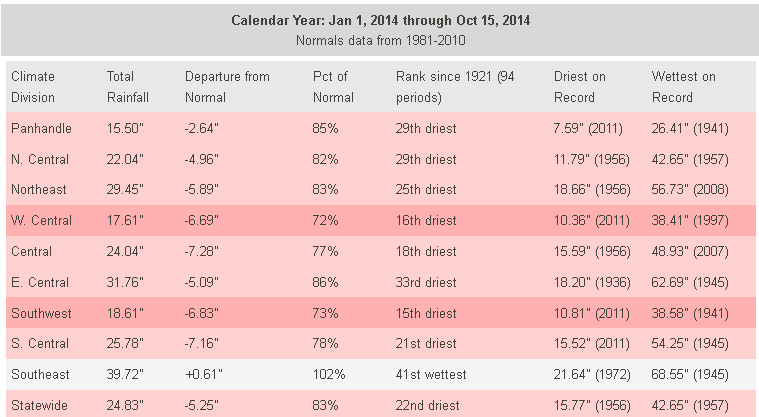
The statewide average at 24.83" is still over 5" below normal, and that makes
this Jan. 1-Oct. 15 period the 22nd driest since at least 1921. And from the
maps, it's obvious that the west central and SW sections of the state are still
hurting terribly.
What about the future? Looks better according to the NWS' Climate Prediction
Center in the long term, not so much according to forecasts in the short term.
Let's start with the 7-day moisture forecast.

Bleak. Enjoy the nice weather.
Let's go out to Halloween, courtesy of our Canadian friends. Chances of
accumulating at least an inch through Halloween?
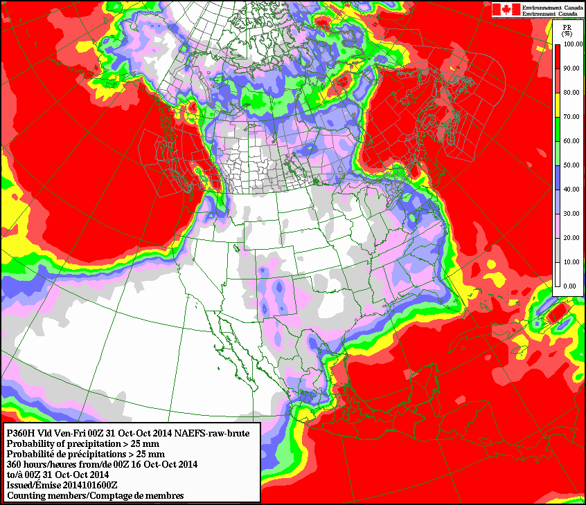
Bleak. Enjoy the candy.
How about for November itself?
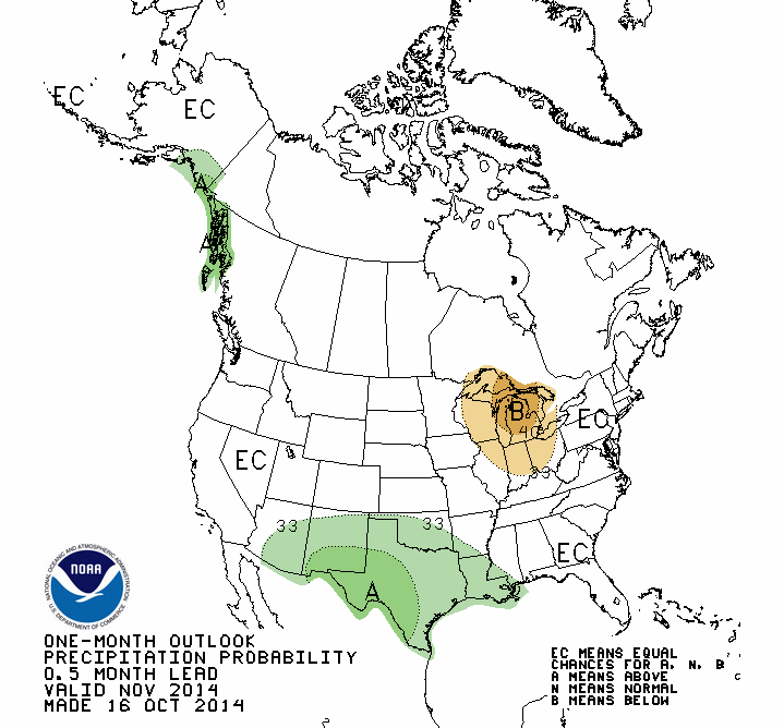
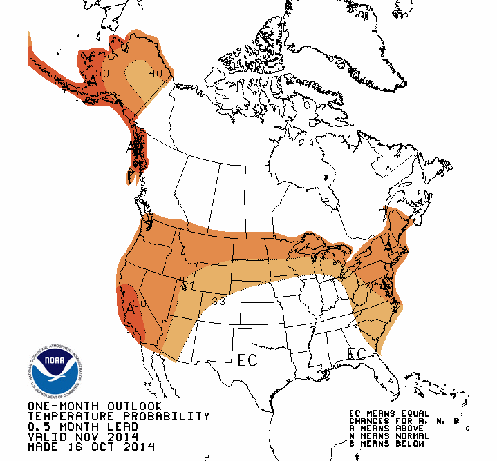
We see increased odds for above normal precip, at least for most of the state.
Temperature anomalies (or lack thereof) are indeterminate.
November through January? About the same thing as November, except add in
increased odds of below normal temperatures.


The CPC forecasters are predicting a classical El Nino response in the Southern
Plains weather pattern, with other forecasters still predicting about a 65%
chance that a weak El Nino will develop within the next month or two and
last through early spring (but remain weak). We still believe a weak El Nino
could spell drier weather for Oklahoma, just based on October-March rainfall
summaries through weak events. But, we've been wrong before.
WE HEARD THAT!
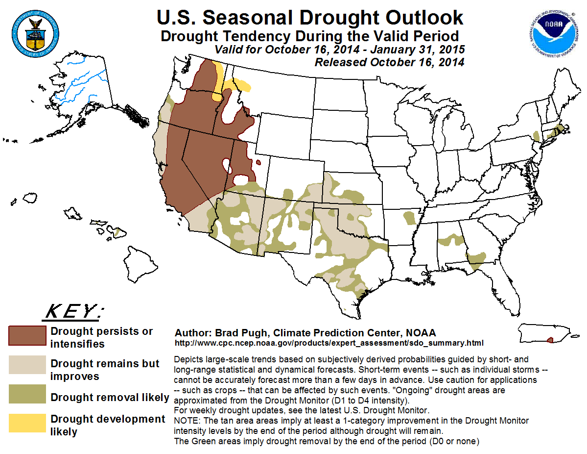
However, in the event we get a good response from either El Nino or due to
various other factors, CPC is prediction some drought relief and even removal
through January.
Come rain, snow, ice, sun or gray, what will happen will happen, right? As
always, we'll try and tell you exactly which...after they occurred.
Gary McManus
State Climatologist
Oklahoma Mesonet
Oklahoma Climatological Survey
(405) 325-2253
gmcmanus@mesonet.org
October 16 in Mesonet History
| Record | Value | Station | Year |
|---|---|---|---|
| Maximum Temperature | 102°F | SLAP | 2016 |
| Minimum Temperature | 24°F | SEIL | 2024 |
| Maximum Rainfall | 3.54″ | HOLL | 1994 |
Mesonet records begin in 1994.
Search by Date
If you're a bit off, don't worry, because just like horseshoes, “almost” counts on the Ticker website!