Ticker for September 4, 2014
MESONET TICKER ... MESONET TICKER ... MESONET TICKER ... MESONET TICKER ...
September 4, 2014 September 4, 2014 September 4, 2014 September 4, 2014
Hello Dolly!
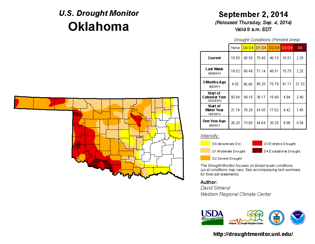
This morning's release of the U.S. Drought Monitor map shows some discouraging
signs of our old friend "Flash Drought" making an appearance once again. It's
difficult to say whether this would really be considered a flash drought
situation (i.e., the sudden stop of appreciable moisture coupled with above
normal temperatures creating a relatively sudden increase in short-term drought
impacts) or just "re-intensification," since drought is already in place over most
of the state. Here's the latest drought map showing an increase in drought
across west central Oklahoma, as well as some relief across the far NW.
That temperatures have been above normal over the last 2-3 weeks is not a
surprise to anybody living here, and we've commented quite often that after
a decidedly cool June-July period, all these 100s (whether they were actual air
temperatures or heat indices) are a shock to the system. Let's look at the
temperatures for a quasi-random period...Aug. 14-Sept. 3 ,for example. Over that
3-week period, the statewide average high was 95 degrees, which is 2.8 degrees
above normal. Okay, we got the heat. How about the sudden stop of appreciable
moisture? Well, I think this one map really tells us all we need to know, the
consecutive days with less than at least a quarter inch of rainfall.
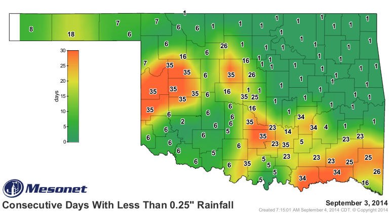
You can see things have gotten pretty bad across west central and SE Oklahoma,
even spreading into parts of central Oklahoma. Just look at the rainfall
maps from the beginning of August to see the real damage (along with the heat)
being done.
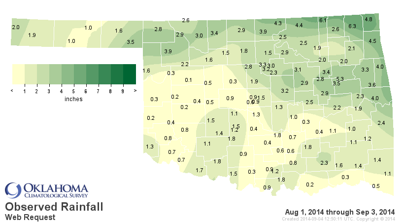
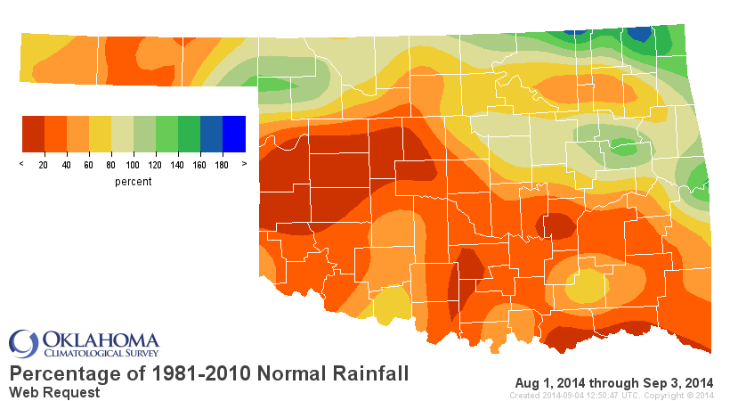
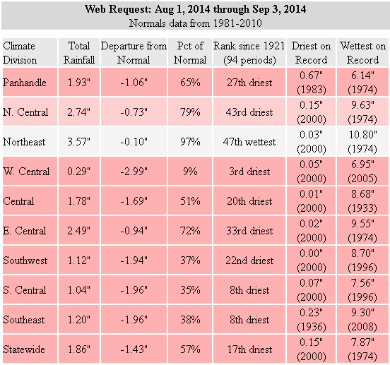
Less than a half-inch of rain across much of west central Oklahoma, as well as
the far southeast (and other areas here and there). That adds up to the 17th
driest Aug. 1-Sept. 4 period since at least 1921. For west central Oklahoma,
it's the 3rd driest. Add that sudden loss of moisture to the heat we've been
seeing and you do have the basic ingredients for flash drought intensification.
Some of the impacts are obvious. Lakes across western Oklahoma (and a few other
parts...I keep saying that because I don't want to ignore those folks in
trouble in other areas of the state) remain precariously low, as shown in this
graphic from the Oklahoma Water Resources Board.
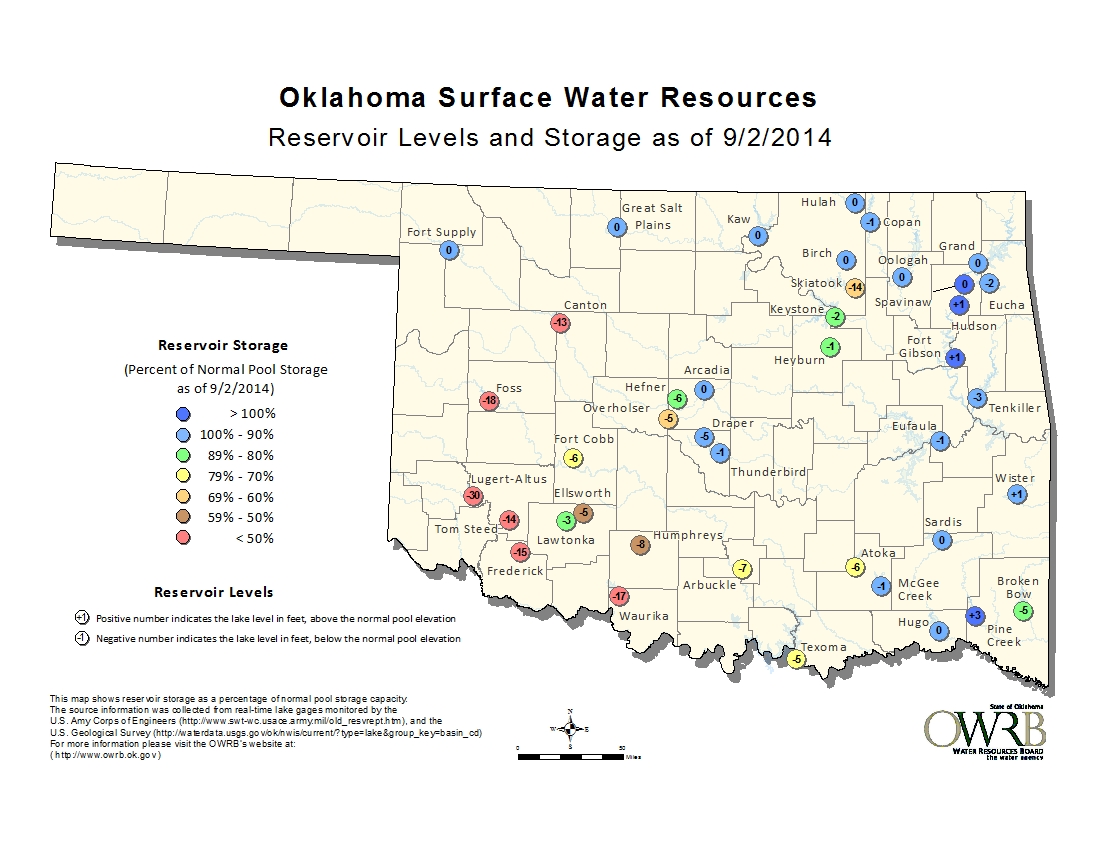
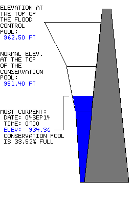
The low lake levels at Lawtonka, Ellsworth and Waurika (total capacity now less
than 50 percent) has forced the city of Lawton into Stage 3 water conservation,
meaning all outdoor watering must take place between midnight-9 a.m. on
Wednesdays and Saturdays. The biggest culprit is Waurika Lake, which is at 34
percent of normal capacity.
Comanche County also just implemented a 30-day burn ban due to a spate of recent
wildfires across Comanche and Stephens counties as the vegetation continues
to wither and go dormant/die in the droughty conditions.
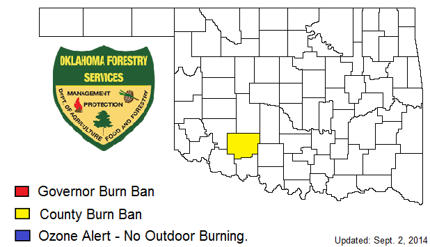
Only one county thus far, which is good news. Soil moisture is still
deteriorating at the upper and lower levels as well. As of September 1, the
National Agricultural Statistics Service (NASS) had 67% of the subsoils and 56%
of the topsoils across Oklahoma categorized as "short or very short" of moisture.
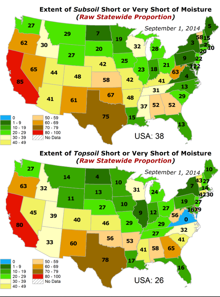
Those types of topsoil conditions are not too far out of the ordinary for this
time of year. It's what you would expect after a "normal" summer, but after
this go-round I think it's a combination of long-term impacts and short-term
intensification wrapped around a rainy summer. So we got to "normal" there by
being anything BUT normal. The subsoils are definitely not where they should
be however, and that is assuredly a long-term drought impact.
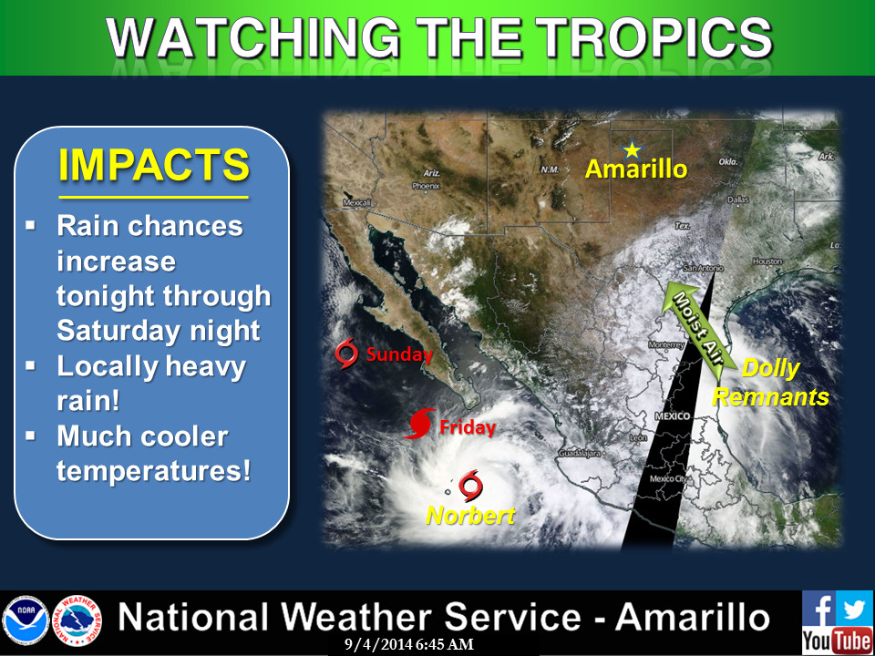
Okay, now for the good news...here comes some rain! And it looks like parts of
the state will finally get their best chances for decent moisture in over a
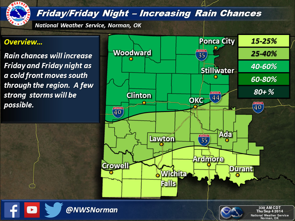
month. We have a front approaching the state on Friday that is likely to
stall out in the area, acting as a focus for showers and storms. In addition,
we have moisture from the remnants of Tropical Storm Dolly in the Gulf of
Mexico and also from Hurricane Norbert in the Pacific that should both contribute
to some really healthy moisture totals, especially in the Panhandle and western
OK regions. This is a classic setup to get the High Plains some rain as we
see moisture stream up from both the Gulf (Dolly) as well as the Pacific
(Norbert)...sort of a SW monsoon on steroids. It's also a complicated setup, so
I'll just leave it up to our friends at the local NWS offices to clear things
up (or cloudy things up, in this case).
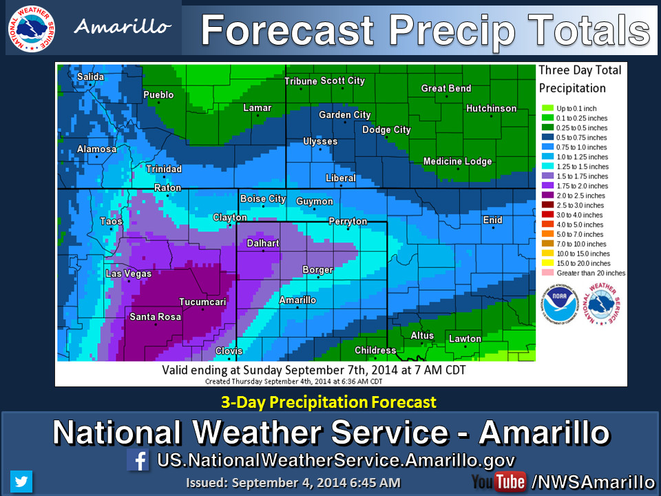
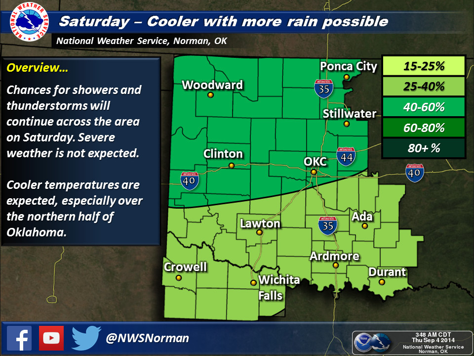
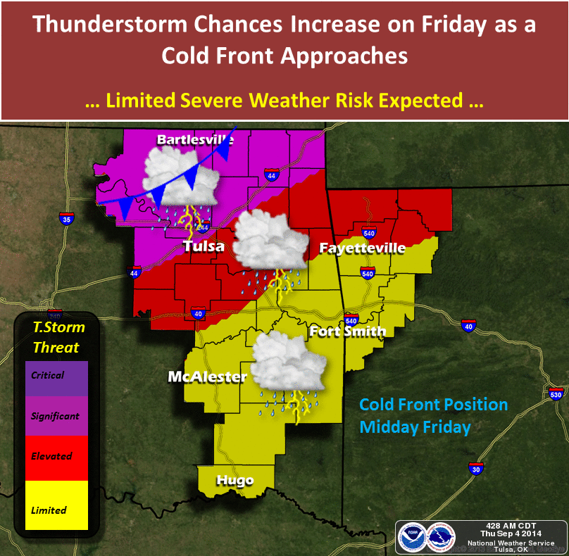
Rainfall amounts of up to 2 inches and greater are possible across the High
Plains region, with some of those generous totals approaching west central
Oklahoma (flash drought central!).
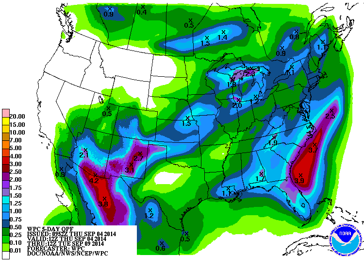
While we still need rain where drought has again started to intensify across
southern and SE Oklahoma, maybe we can relieve or stave off some of that
drought intensification occurring across west central Oklahoma. This is really
a High Plains event that the rest of the state might get to share in, which
is the opposite of what normally occurs.
Gary McManus
State Climatologist
Oklahoma Mesonet
Oklahoma Climatological Survey
(405) 325-2253
gmcmanus@mesonet.org
September 4 in Mesonet History
| Record | Value | Station | Year |
|---|---|---|---|
| Maximum Temperature | 112°F | WALT | 2000 |
| Minimum Temperature | 43°F | BOIS | 2008 |
| Maximum Rainfall | 4.22 inches | MANG | 1996 |
Mesonet records begin in 1994.
Search by Date
If you're a bit off, don't worry, because just like horseshoes, “almost” counts on the Ticker website!