Ticker for September 2, 2014
MESONET TICKER ... MESONET TICKER ... MESONET TICKER ... MESONET TICKER ...
September 2, 2014 September 2, 2014 September 2, 2014 September 2, 2014
The August summary (dry and
Well, we obviously had a wild and crazy night last night thanks to that cold front
sagging into northern Oklahoma, and now it's the gift that keeps on giving. Storms
continue to move south through the state bringing much-needed rainfall (stay
tuned for the August summary below!) with them. Here's the radar summary as I type
this, as well as the rainfall totals from last night and this morning.

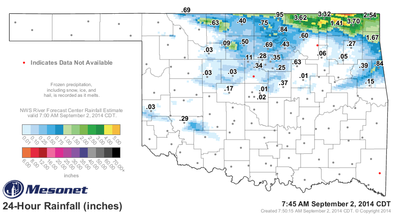
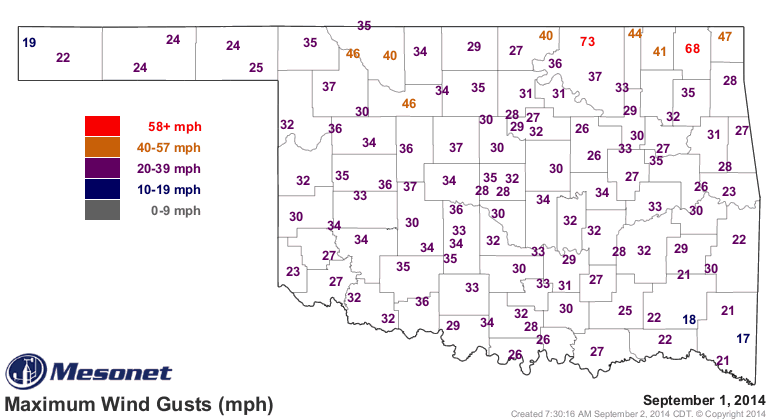
Lots of severe weather with the storms as well, including tornado warnings for
Osage County. We had almost forgotten what a tornado warning meant until last
night (the counties on the TV turn red!). There were also some mighty powerful
winds (73 mph at the Foraker Mesonet site in Osage County, 80 mph in Bartlesville
from the Emergency Manager), large hail and flooding rains.
With all that excitement ongoing, I now bring you back to earth with something
from the far past (well, two days ago at least). Hey, don't blame me, I didn't
put Labor Day on Sept. 1st!
-------------------------------------------------------------------------------
Summer Marks Return During August
August made a valiant effort to continue the unusually cool and remarkably wet
conditions of June and July and place a final exclamation point on one of the
more enjoyable Oklahoma summers in recent memory. Unfortunately, that message
was lost during the month's final two weeks as the heat and dry weather of a
normal Oklahoma summer found their way back to the state. According to
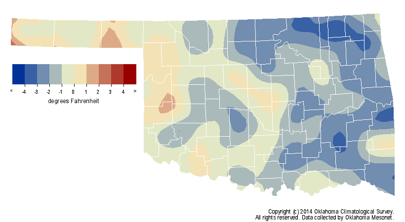
preliminary data from the Oklahoma Mesonet, the mild first half and summery
second half of the month combined to produce a statewide average temperature of
80.6 degrees, two-tenths of a degree above normal and the 57th coolest August
since records began in 1895.
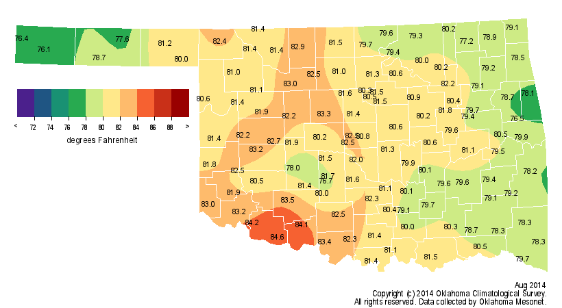

Even that statistic was somewhat misleading, however, as the abundant moisture
across eastern Oklahoma produced heat indices well into the triple-digits at
times. The highest actual air temperature measured by the Mesonet was 105
degrees at several locations, certainly nothing out of the ordinary for August
in Oklahoma. But the heat index often topped that mark, with Lane recorded a
state-leading 112 degrees on August 8. The Mesonet recorded heat index values
greater than 105 degrees 57 times during August. The climatological summer
ended as the 26th coolest on record with a June-August average temperature of
78.7 degrees, nearly a degree below normal.
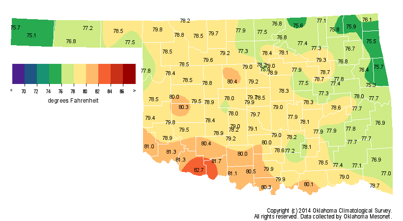
The summer's highest temperature, 107 degrees, was recorded by the Mesonet at
several locations during June and July.
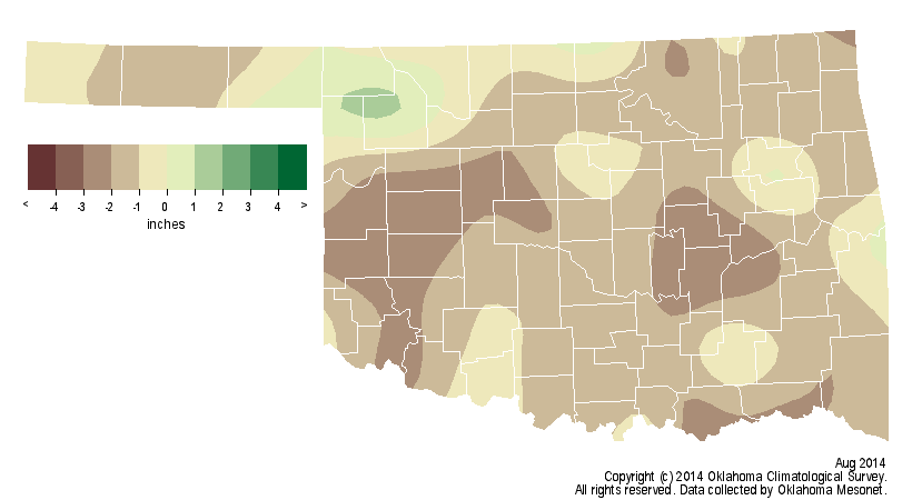
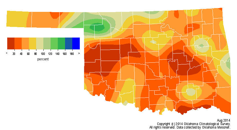
Only a late-month storm system saved Oklahoma from one of its top-five driest
Augusts on record. There were a few locations that recorded generous moisture
amounts. The Mesonet site at Porter led the state with 4.1 inches and several
other stations across northern Oklahoma reported more than 3 inches, but 50
Mesonet stations recorded less than an inch for the entire month. Okemah and
Putnam brought up the rear with a tenth of an inch in each of their gauges
during August. The statewide average precipitation total of 1.4 inches was half
of the normal total for August and the 12th driest since records began in 1895.
West central Oklahoma suffered through its third driest August on record with
an average of 0.3 inches.

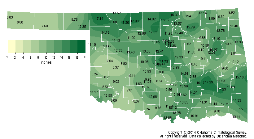
The summer as a whole was still wetter than normal, however, with a statewide
average of 11.4 inches, 1.6 inches above normal to rank as the 34th wettest on
record. North central Oklahoma had a near miraculous recovery from a disastrous
first five months of the year with its 11th wettest June-August on record, 4.5
inches above normal.

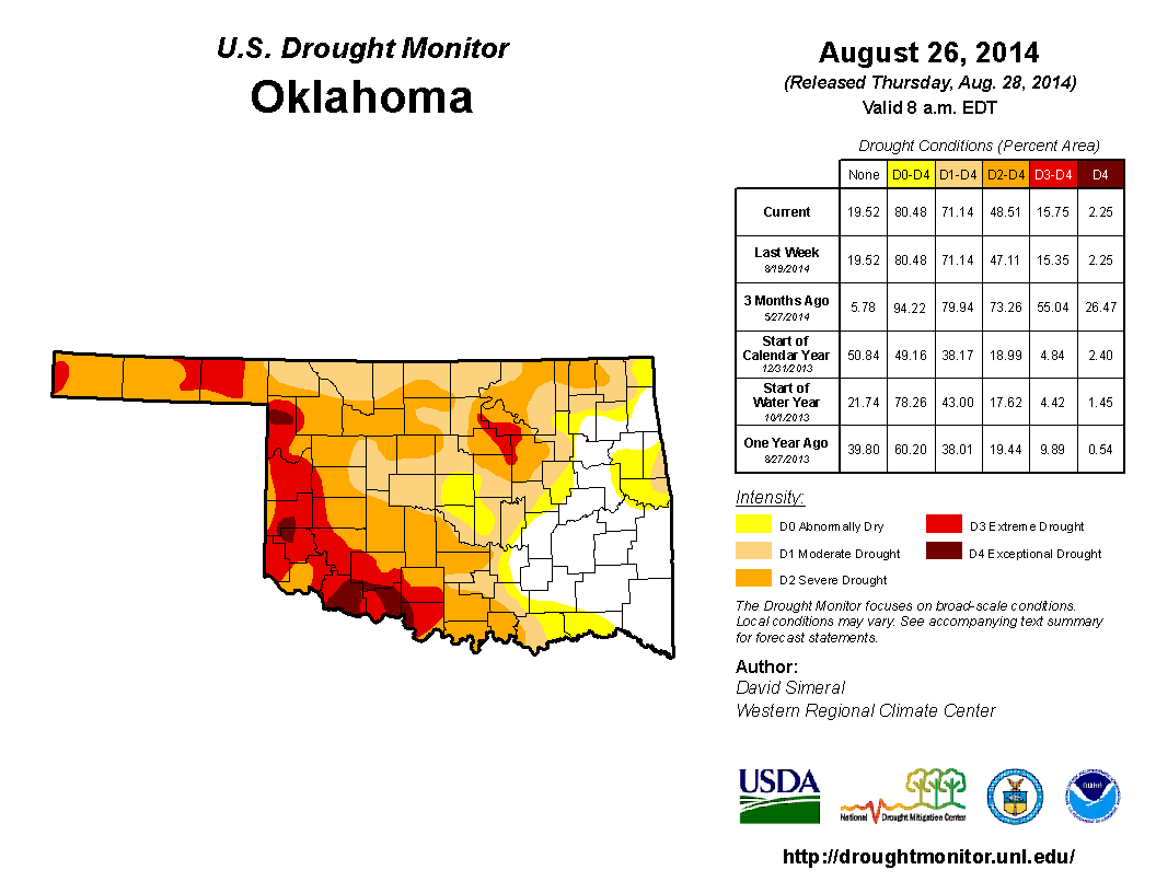
The drought relief that was so prevalent from late May through July dwindled
along with the rains during August. The month's final U.S. Drought Monitor
actually saw a slight increase in drought from the previous week as a result of
the extended period of hot, dry weather. That final map portrayed approximately
49 percent of the state in at least severe drought, with 16 percent of that
amount in the extreme-to-exceptional drought categories. The Drought Monitor?s
intensity scale slides from moderate-severe-extreme-exceptional, with
exceptional being the worst classification. The worst of the drought remained
from southwestern through northwestern Oklahoma. Roughly 29 percent of the
state, mostly across southeastern Oklahoma, was considered to be free of any
abnormally dry conditions.
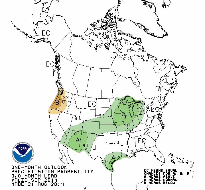
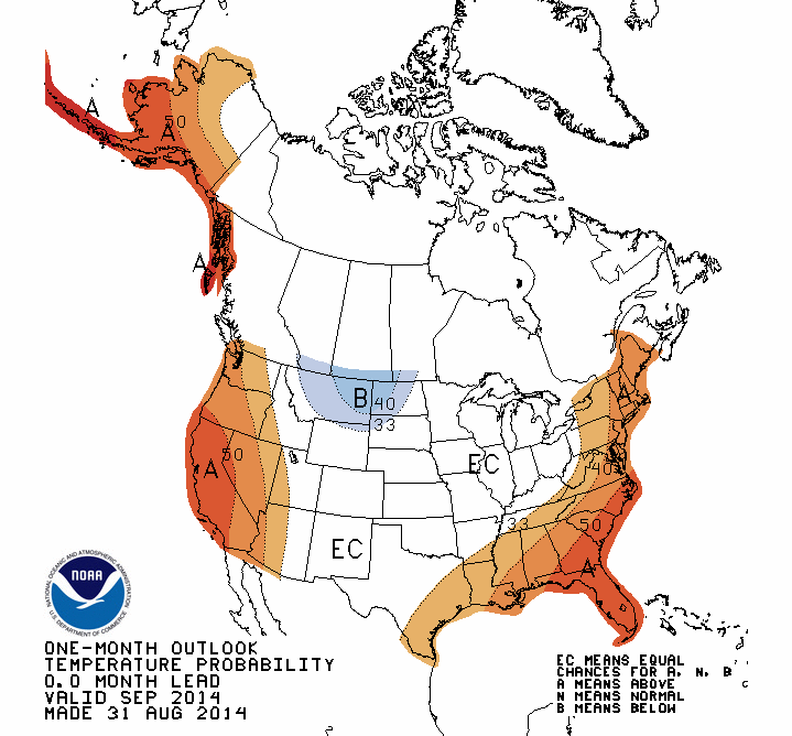
The September outlooks from the National Weather Service's Climate Prediction
Center (CPC) gave no indication of any temperature or precipitation anomalies
for Oklahoma with both indicating equal odds for above-, below- or near-normal
conditions.
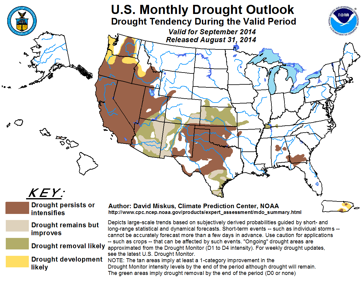
Unfortunately, given those uncertain conditions, CPC's Monthly Drought Outlook
for September indicated that drought was expected to either persist or
intensify throughout the month.
CPC's seasonal outlooks for September-November point towards increased odds for
below normal temperatures across the northwestern half of the state as well as
above normal precipitation for all of Oklahoma.
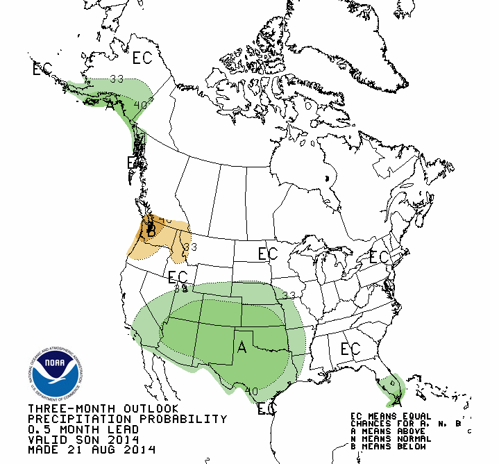
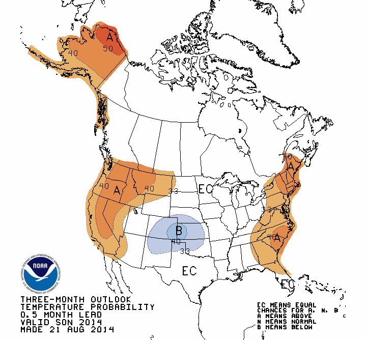
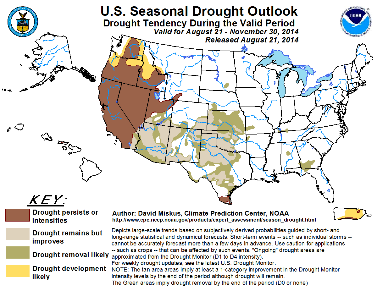
Those outlooks yield a U.S. Seasonal Drought Outlook with plenty of optimism
for drought improvement or removal across much of the western two-thirds of the
state by the end of November.
Gary McManus
State Climatologist
Oklahoma Mesonet
Oklahoma Climatological Survey
(405) 823-9054
gmcmanus@mesonet.org
September 2 in Mesonet History
| Record | Value | Station | Year |
|---|---|---|---|
| Maximum Temperature | 111°F | TALI | 2000 |
| Minimum Temperature | 49°F | BOIS | 2006 |
| Maximum Rainfall | 2.86″ | CHAN | 2014 |
Mesonet records begin in 1994.
Search by Date
If you're a bit off, don't worry, because just like horseshoes, “almost” counts on the Ticker website!