Ticker for August 13, 2014
MESONET TICKER ... MESONET TICKER ... MESONET TICKER ... MESONET TICKER ...
August 13, 2014 August 13, 2014 August 13, 2014 August 13, 2014
Westville, Minnesota...I mean Oklahoma!
Did ya know that the Mesonet site in Westville (located in Adair County in far
eastern OK) has only seen temperatures at or above 90 degrees 9 times this year?
NINE TIMES!
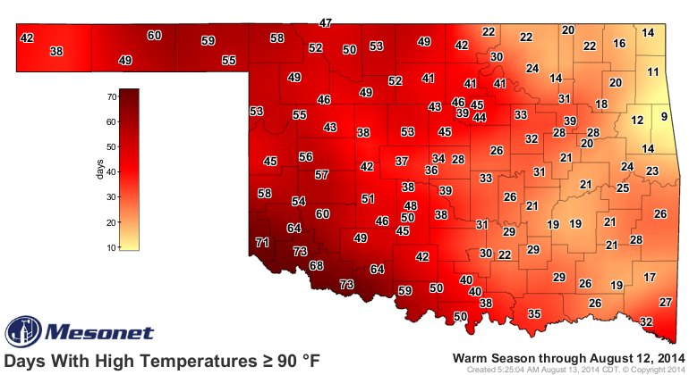
Other stations over that way have similar totals...Jay with 11, Tahlequah with
12, Miami and Cookson at 14. And while it hasn't been too extravagant, the
western half of the state has seen many more 90s. Now that is also somewhat
ordinary...western Oklahoma tends to get the higher air temperatures without
the moderating moisture eastern Oklahoma sees, but it is a bit more pronounced
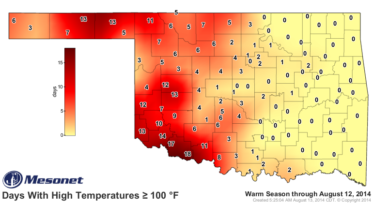
this year. Even in the 100-degree-or-above map (albeit another wimpy map
compared to recent summers).
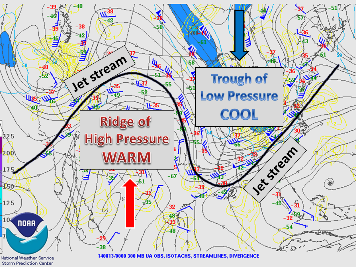
This is actually pretty consistent with the large-scale pattern the U.S. has
been faced with since the beginning of the year. In essence, the upper-air
pattern has kept a trough of low pressure ensconced over the eastern half of
the U.S. while the western half of our country has seen an upper-level
ridge of high pressure. As you are all aware, I'm sure, as that jet stream has
soared far to the north in the West and plunged far to the south across the
East, that means lots of warmth and drought across the west and cooler air and
moisture in the east. And in the middle somewhere, in the battle-zone between
this ridge and trough, likes Oklahoma, held hostage by the shifting of that
ridge/trough axis a few hundred miles to the east or west. Sometimes we're under
the eastern regime, sometimes under the western regime.
Let me explain with a very crudely drawn picture, using my box of 12 crayons.
Yeah, I never got the 64 crayon box, WITH a sharpener!
So northeastern Oklahoma in general is cooler, but it has also seen a bit more
influence by that eastern/cooler air mass, while western OK and the Panhandle
has gotten the western slap of the jet stream's hand. Check out the January-
July temperature rankings for each state in the U.S. to see more evidence of
this persistent upper-level air pattern, all controlled by our friend (and
enemy) the JET STREAM!

A pretty striking dichotomy, no? California has EASILY seen it's warmest January-
July period on record...it's not even close
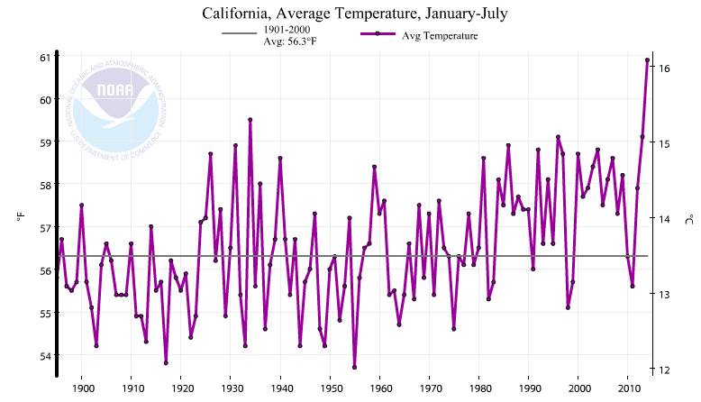
and states stuck under that trough for most of the year are seeing their top-10
coolest January-July periods. The Central Plains (the Dakotas down through
Oklahoma) shows up as the battleground states; not quite top-10 coolest, but
somewhere between 15-40th coolest. Given our location just to the east of the
Rocky Mountians, as that cold air plunges down, it sort of pools up against
those mountains. So we're not quite top-10, but we are definitely seeing the
influence of the trough more so than the ridge. Oklahoma's 16th coolest ranking
is a bit of an anomaly for the center of the Plains, so it is probably aided by
all the moisture we've seen during the summer. A wetter summer means a milder
summer.
Of course this is simplified. Earlier in the year when that ridge-trough axis
would slide over us, we'd get a strong cold front and no return moisture from
the Gulf of Mexico to produce precipitation. Later in the spring and into
summer, as we've slid under the trough, we've seen a strong lower-level jet
from the south bringing up lots of moisture to interact with. But we can't deny
this is a summer like no other. Well, since 1994, at least, and a far cry from
those of the last few years. Here are the 90-degree days from the last few years
(through August 12) and also the 100-degree days. I've thrown in the chilly
year of 2004 as well, just for comparison to this year.
90 Degree Days (Jan 1-Aug 12)
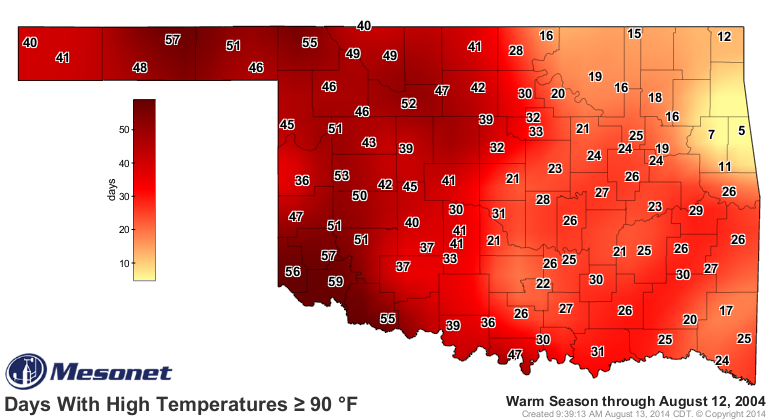

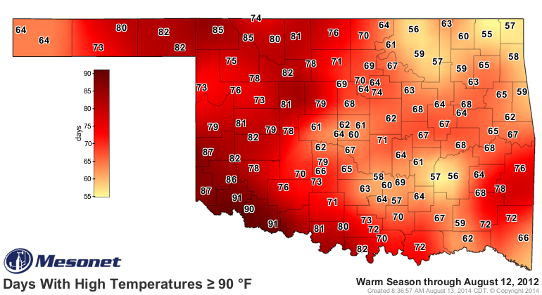
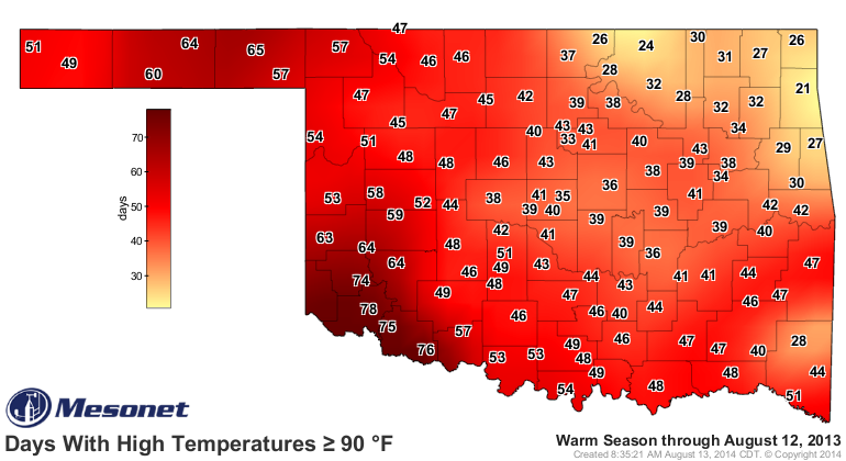

100 Degree Days (Jan 1-Aug 12)
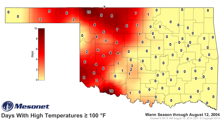
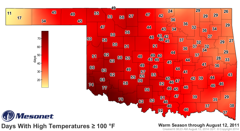
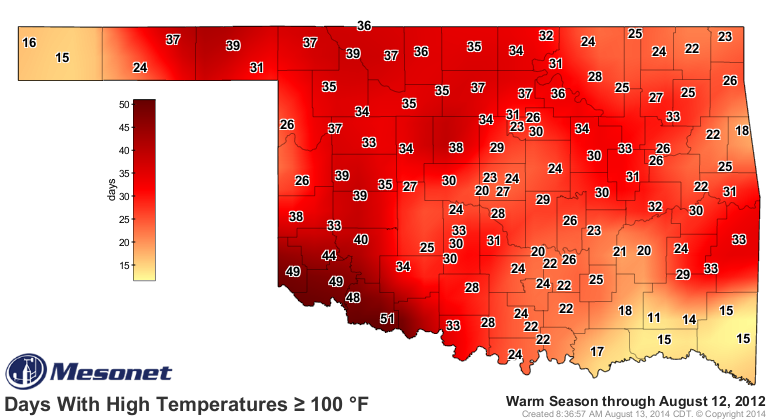


So there you have it...a very simplified explanation of this year's sorta crazy
weather from a very simplified brain. Blame it on the Jet Stream!
Gary McManus
State Climatologist
Oklahoma Mesonet
Oklahoma Climatological Survey
(405) 325-2253
gmcmanus@mesonet.org
August 13 in Mesonet History
| Record | Value | Station | Year |
|---|---|---|---|
| Maximum Temperature | 110°F | GRA2 | 2023 |
| Minimum Temperature | 48°F | MIAM | 2004 |
| Maximum Rainfall | 5.89 inches | SALL | 2017 |
Mesonet records begin in 1994.
Search by Date
If you're a bit off, don't worry, because just like horseshoes, “almost” counts on the Ticker website!