Ticker for August 7, 2014
MESONET TICKER ... MESONET TICKER ... MESONET TICKER ... MESONET TICKER ...
August 7, 2014 August 7, 2014 August 7, 2014 August 7, 2014
Summer drought relief still going strong. El Nino...not so much.
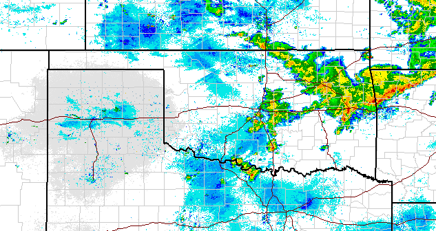
For the umpteenth Thursday in a row, it seems, it is raining as I send out the
latest U.S. Drought Monitor release. As usual, please remember that the rains
that have fallen after Tuesday morning won't be taken into account on the DM
until next week. But...there hasn't been THAT much rain this week. Just some
brief heavy downpours in C OK and some more widespread rains to the east.
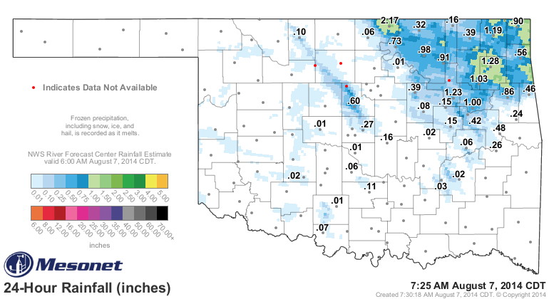
But we're working with much more widespread and heavy rains for this week's DM
release, and adding that to earlier rains. It does add up, after all. We'll just
show a 10-day total to make sure we get a good picture of the moisture that has
fallen (for a fun exercise, go through and subtract what has fallen in the last
24 hours...get your crayons out for the color contours).
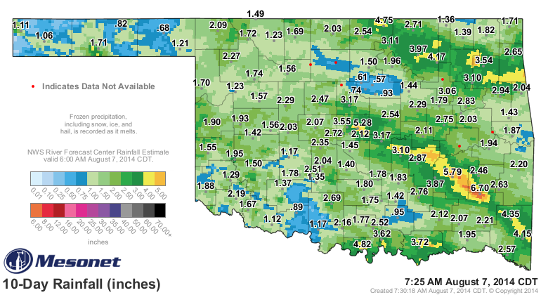
Most of the state is at least in the green on that map. For some reason there is
a blue streak over Payne County. The Stillwater rain bubble is still in effect,
I guess. As regular Ticker readers recall, however, we've tracked this rain all
the way back to May 21, when the real spring rainy season seemed to have begun.
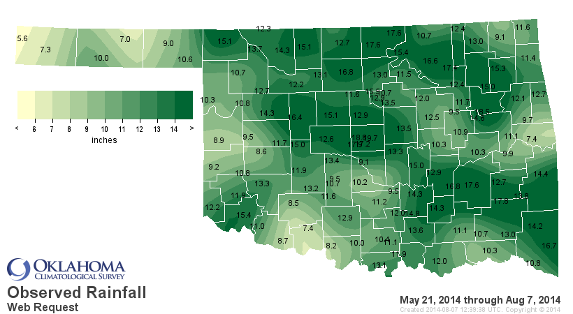
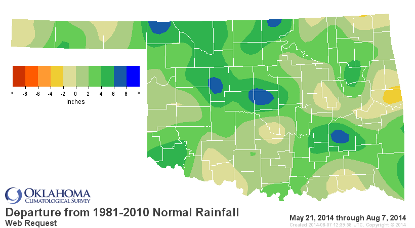
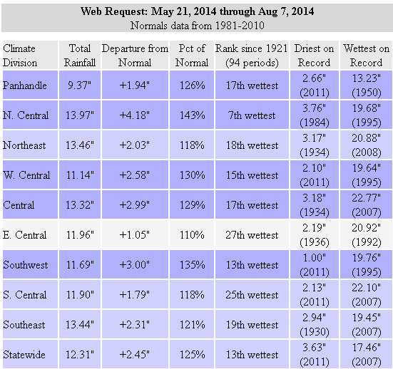
Over 12" statewide over that 10-week'ish period since May 21, the 13th wettest
such span since at least 1921. Not quite the 17.46" from 2007 (remember, the
June where it just wouldn't stop raining, the wheat crop rotting in the fields,
etc.?), but this will work for us just fine. And most of Oklahoma County
appears to be ground zero for the highest totals as the Oklahoma County
mesonet sites have seen from 17-20 inches of rainfall since May 21.
Without further ado, even though I have no clue what "ado" is, here is this
week's U.S. DM map in all its glory.
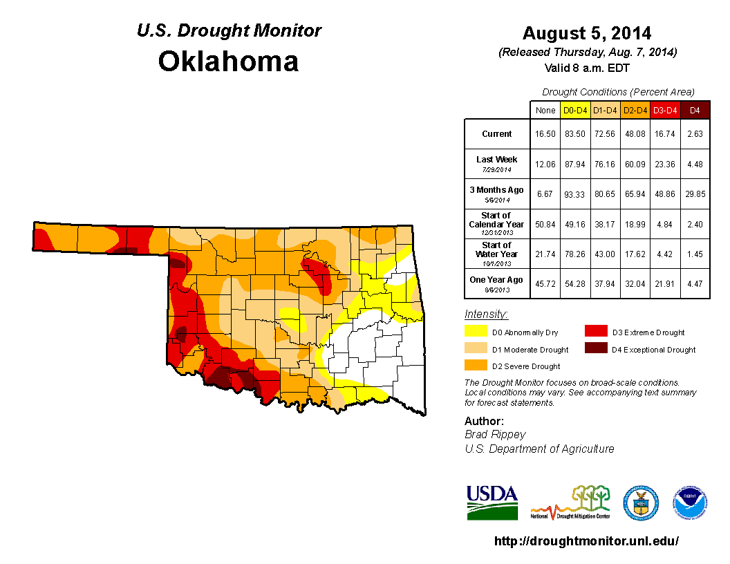
A lot of white, what a wonderful sight. A lot less red with the ground being
fed (moisture). All the best poets use parentheses, no? Check out that
statistics table to the side for the best news. Now only 17% of the state
resides in the Extreme-Exceptional (D3-D4) drought categories. And only 48%
is in at least Severe (D2) drought. We thought of pushing for that D1 area that
has expanded in central OK to meet up with the downgraded D1 areas in NC OK, but
maybe we can do that soon with more rains. But we have had a substantial drop
in drought impacts in the state in just the last 3 months, from 49% in D3-D4 to
that 17% amount. So the drought relief continues, spreading from east to west.
Most of the drought impacts we see now are long-term impacts, such as surface
water deficits, deeper soil moisture deficits, ground water levels, etc. And
that is because we are still dealing with deficits of 20-30 inches since the
beginning of the drought in October 2010, and also just from the beginning of
this year.
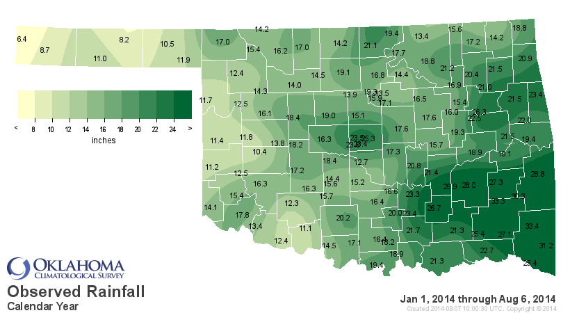
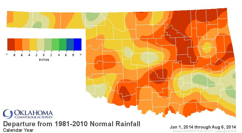
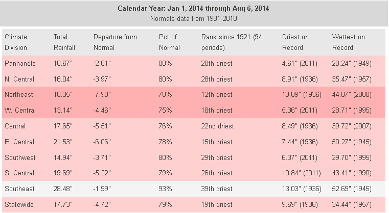
Thanks to that dry first 4.75 months of the year, we're still dealing with a
deficit of close to 5 inches for the Jan. 1-Aug. 6 period, the 19th driest since
at least 1921. You can see evidence of some of those long-term drought impacts,
such as the lake level map from the Oklahoma Water Resources Board. Notice that
a lot of those lakes across western Oklahoma are still below 50% of normal
capacity, definitely a long-term drought impact needing a long-term drought
remedy.
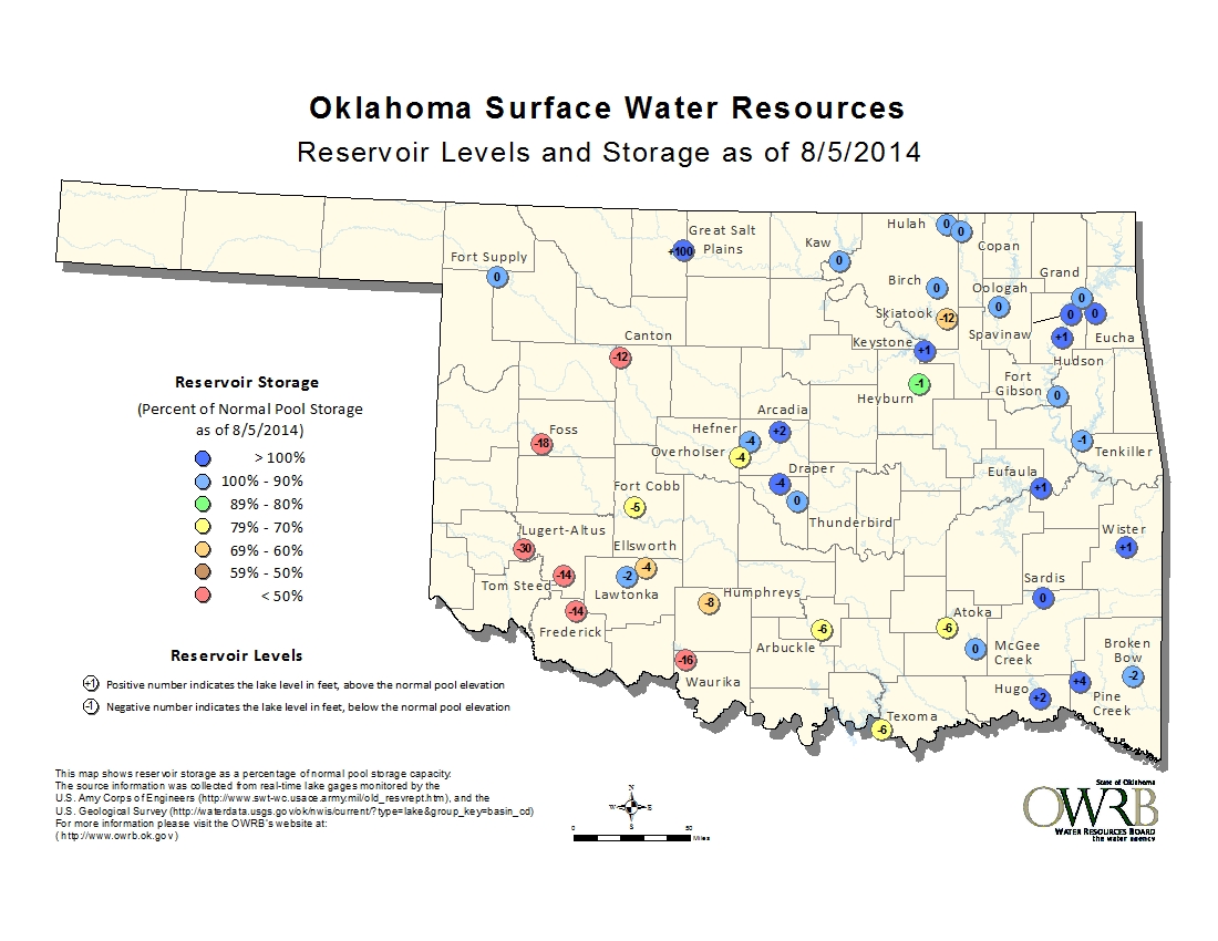
Canton Lake, for instance, is still 25% of normal capacity, despite plenty of
rain in Blaine County. That's a sure sign that the shorter-term impacts, like
soil moisture deficits and low farm ponds, are stealing the moisture away in
the Canton Lake watershed before it can make it to the lake. That's the key to
ending drought...the soils drink first, then the runoff will occur more readily
and make it down the streams and rivers, past full farm ponds, to the lakes.

The short-term impacts, like topsoil moisture and vegetation health, are
definitely in pretty good shape for late summer.
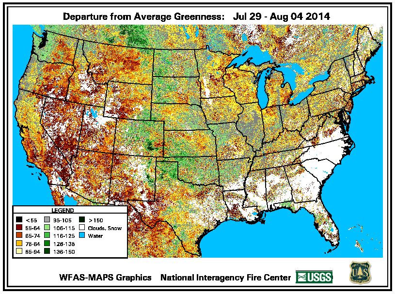
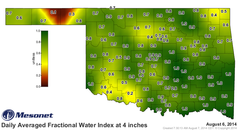
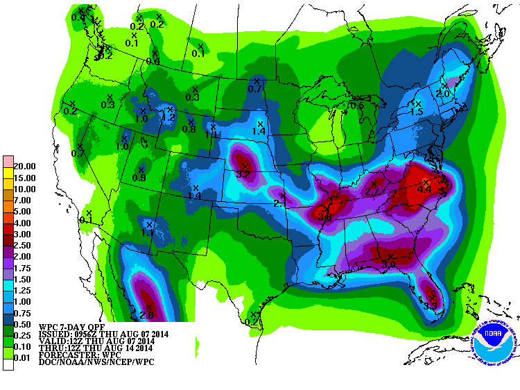
Still a few rough spots showing up even in those maps, however. The weather for
the next week or so looks mostly dry with a chance for spotty rain showers
(sometimes heavy rain in localized areas). Since we're under that ridge of high
pressure that has suddenly returned us to summer, you can see how we might see
a good portion of moisture up and along the edges of that ridge over us across
northern Oklahoma.
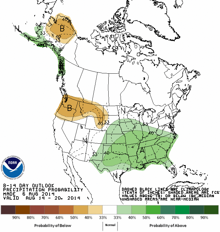
This is a time of year when evaporation and those plants will be taking more
than what is being dropped, however, so we have been fortunate to have received
so much moisture through late June through July. What we get in August, the
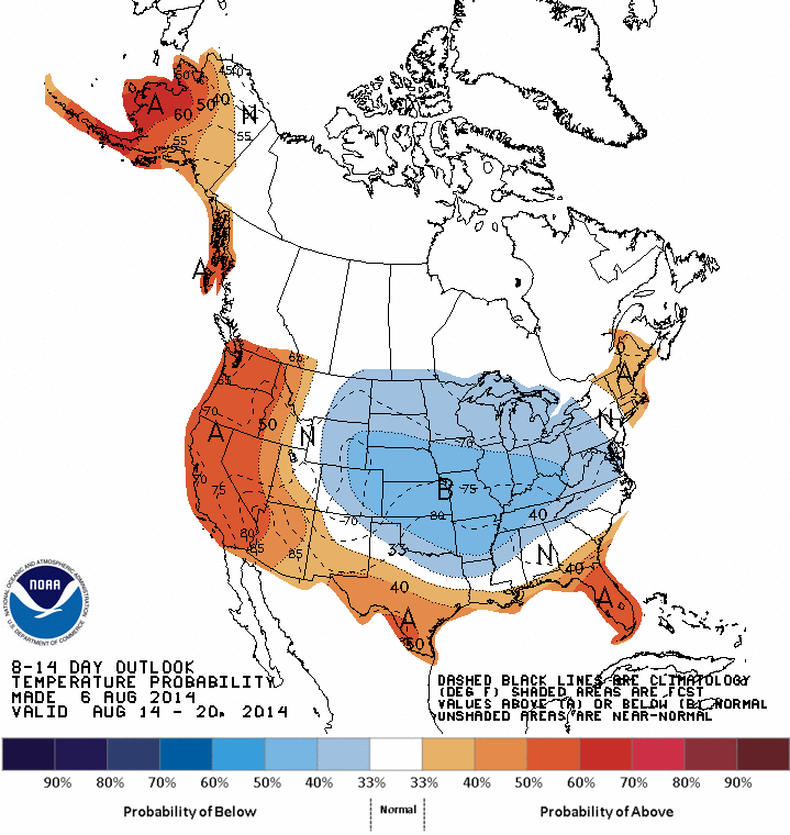
true doldrums of summer, is all a bonus. CPC is still showing hints of cooler
and wetter than normal weather 8-14 days out, so if we can get that, we'll
keep drought at bay as we go through August.
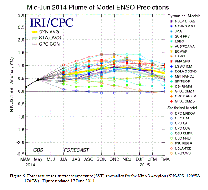
Now for the bad news. The El Nino we were expecting for this winter is becoming
a little less certain. The new ENSO (El Nino/Southern Oscillation) outlook
from CPC this morning now has the odds of an El Nino event forming for this
cool season at around 65%, and the chances for a strong event are now very low.
You can see the modeled output on this graphic with the sea surface anomalies
in the key ENSO region across the equatorial pacific staying above that +0.5C
temperature area, signalling El Nino, but not much chance of the +1.5C anomalies
needed for a strong event.
A few key points, and obviously I'm simplifying a quite complicated science down
to the bare bones here:
1) An El Nino even HAS NOT developed yet. We are still in the ENSO-Neutral
category. In fact, the temperature anomaly in the key ENSO region has actually
dropped into the weakly negative territory recently. Regardless, impacts for
our area are not evident until the cool season during El Nino episodes (if at
all).
2) The other components of El Nino, such as the weakening of the predominant
easterly winds (or even switching to weak westerlies) and the changes in
atmospheric pressure across the region, also have to come into focus for a true
El Nino event to be declared.
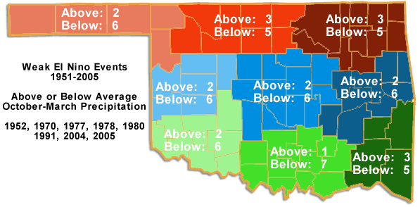
3) Just a caution, and NOT a forecast, but weak El Nino events have shown to
bring drier than normal weather for Oklahoma during the cool season (October-
March).
Quoting from the CPC ENSO update this morning:
" At this time, the consensus of forecasters expects El Ni?o to
emerge during August-October and to peak at weak strength during
the late fall and early winter..."
Just something to keep in mind as we bask in the glory of our summer rainfall
but keep some of the recent extremely dry fall-spring periods in our collective
memories.
In other words, drought ain't over 'til it's over.
Gary McManus
State Climatologist
Oklahoma Mesonet
Oklahoma Climatological Survey
(405) 325-2253
gmcmanus@mesonet.org
August 7 in Mesonet History
| Record | Value | Station | Year |
|---|---|---|---|
| Maximum Temperature | 111°F | MANG | 2003 |
| Minimum Temperature | 52°F | KENT | 1997 |
| Maximum Rainfall | 4.28″ | WEBR | 2020 |
Mesonet records begin in 1994.
Search by Date
If you're a bit off, don't worry, because just like horseshoes, “almost” counts on the Ticker website!