Ticker for July 31, 2014
MESONET TICKER ... MESONET TICKER ... MESONET TICKER ... MESONET TICKER ...
July 31, 2014 July 31, 2014 July 31, 2014 July 31, 2014
One of the highest wind gusts in Mesonet history occurred last night! Oh yeah, it rained too.
Sometimes you wake up to something shocking. In my case, it's usually the mirror.
For the Mesonet QA manager, it's the possibility that there was a 106 mph wind
gust somewhere in the state. Now normally the automated QA will say "wow, that's
pretty high so let's flag it until a human can look at it." Well, that's what
happened last night around 10:15 p.m. As a severe storm (obviously) was moving
through Love County, it produced a wind gust of 106 mph at the Burneyville
Mesonet station. I can't find reports of damage yet, but 106 mph is enough to
do quite a bit of destruction of trees, infrastructure and property. You can
You can see the 106 mph gust on yesterday's Mesonet Maximum Gust map, and also
on the Burneyville meteogram.
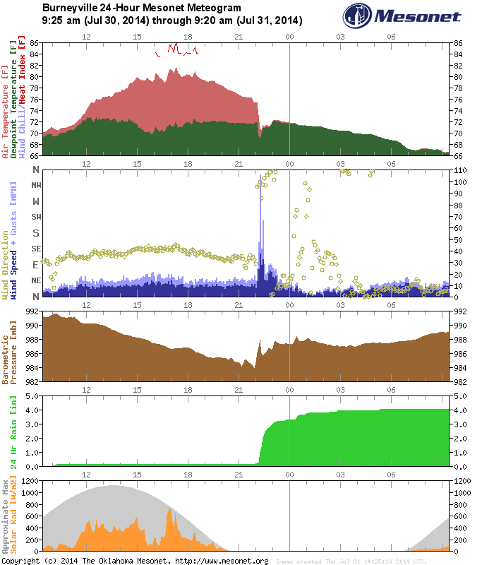

BOOM! That's quite a spike there on the wind graph. Also a jump on the rainfall
graph from a tiny bit to 4 inches. Their heat index apparently pegged out earlier
that day at 86 degrees. Sweltering for April (except it's July).
That also earns Burneyville a much-unwanted spot on the list for highest Mesonet
wind gusts since the network began back in 1994. Here are all the Mesonet wind
gusts of 100 mph or more since 1994.
The Mesonet's 100 mph gusts:
May 24, 2011: 151 mph at El Reno
May 24, 2011: 131 mph at El Reno
August 17, 1994: 113 mph at Lahoma
July 30, 2014: 106 mph at Burneyville
May 4, 2006: 106 mph at Idabel
November 9, 1998: 102 mph at Bowlegs
You'll remember that the top two spots on that list were associated with the
EF5 long-track tornado that brushed the El Reno Mesonet site.
http://ticker.mesonet.org/select.php?mo=05&da=25&yr=2011
Oddly enough, there were very few local storm reports of severe weather last
night, other than some wind gusts in the 60s (including a 66 mph wind gust at
the Burneyville Mesonet site at 10:25pm) and a couple of flash flooding reports
in Choctaw and McAlester. So hopefully those powerful winds were highly localized
and little damage occurred.
-------------------------------------------------------------------------------
Another Thursday U.S. Drought Monitor release, made outdated by Mother Nature
once again with heavy rains on Wednesday and Thursday (reminder: The DM can only
use data through the Tuesday morning time frame). It's like buying expired milk
at Braum's. What's the point?? So here's this week's U.S. Drought Monitor report,
poured into Oklahoma's glass in large, white chunks. Remember, always smell your
Drought Monitor before consuming!
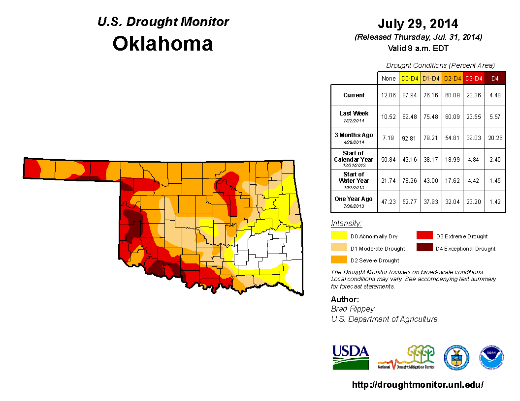
There were not a lot of changes, really...removal of D4 from western Cimarron
County, some decreases in central Oklahoma and a bit of an increase over in
east central areas to moderate (D1) drought. But that's going to pale in
comparison to what happens with next week's map, thanks to the rains over the
last couple of days. And once again, Oklahoma County got blasted, as did parts
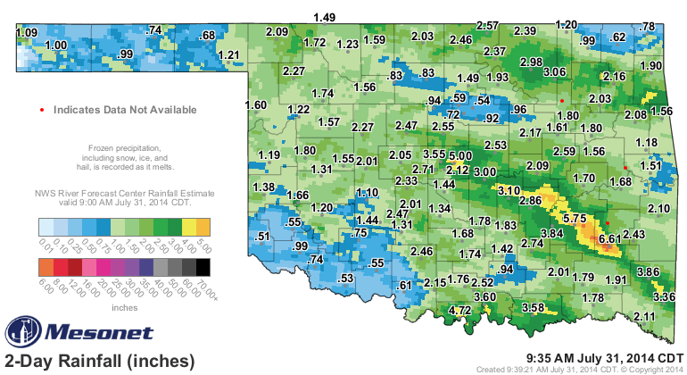
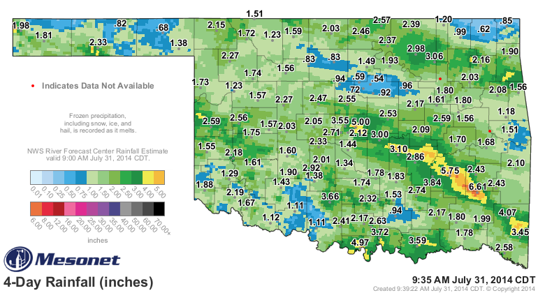
of southeastern and south central Oklahoma. Some of those totals are showing
widespread 4-6 inches, and even a few 8-inch amounts on the radar/gauge
estimates. Check out the 2-day and 4-day rainfall total maps from the Mesonet.
The 4-day map contains some of the rains that went into this week's DM map.
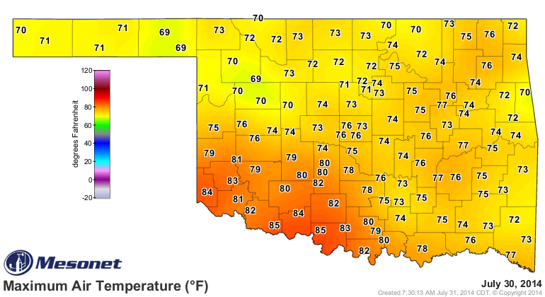
Not only that, but our high temperatures have been held down close to or exceeding
record low levels thanks to the cool air mass in place AND the clouds/rains.
Lots of records undoubtedly fell yesterday.
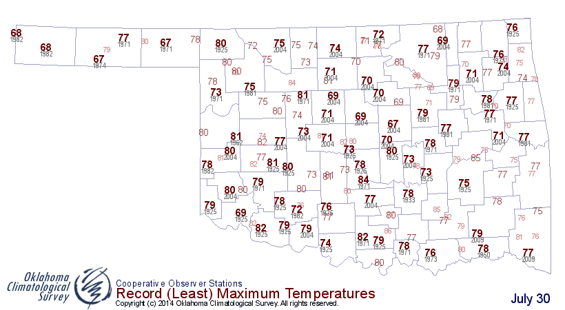
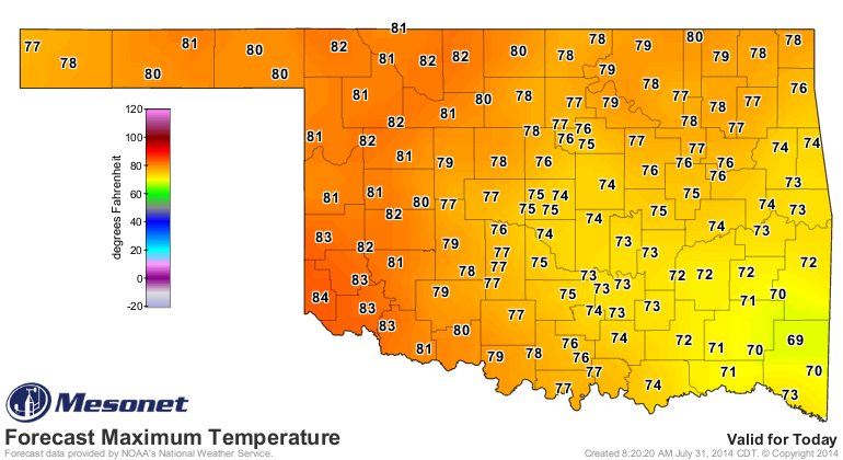
Can we do it again today? Well, here are the forecast highs as the storm
system pulls off to the east, and also the historical low maximum temperature
records that we'll be aiming for. Looks like eastern Oklahoma has a good chance
to come in with some record breakers today.

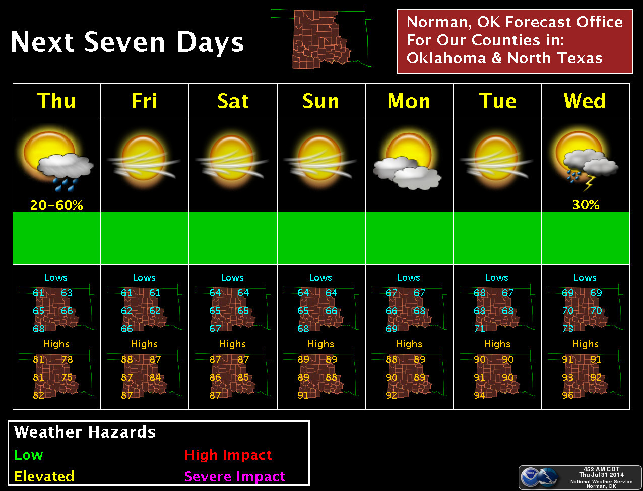
It would appear that we'll continue with below normal temperatures for awhile,
although they will approach more seasonable values as we go through early
next week. Here's the 7-day forecast for the NWS Norman forecast area, but just
extrapolate it outward for the other areas of the state as an example.
Now if you're one of the unlucky few that didn't get a lot of rain (we see ya
Stillwater, Hooker, and Vinita, to name a few), maybe your chance will come
with another of these odd summer cool fronts that is looking possible late
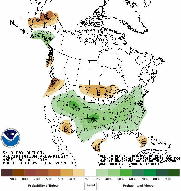
next week. Here are the 6-10 day outlooks from the CPC that are starting to
give us hints of that.

Yep, it's summertime in Oklahoma. Mostly on the calender, nowhere to be found
in the atmosphere, apparently.
Gary McManus
State Climatologist
Oklahoma Mesonet
Oklahoma Climatological Survey
(405) 325-2253
gmcmanus@mesonet.org
July 31 in Mesonet History
| Record | Value | Station | Year |
|---|---|---|---|
| Maximum Temperature | 112°F | MANG | 2012 |
| Minimum Temperature | 50°F | BOIS | 2018 |
| Maximum Rainfall | 5.02 inches | CLAY | 2014 |
Mesonet records begin in 1994.
Search by Date
If you're a bit off, don't worry, because just like horseshoes, “almost” counts on the Ticker website!