Ticker for July 1, 2014
MESONET TICKER ... MESONET TICKER ... MESONET TICKER ... MESONET TICKER ...
July 1, 2014 July 1, 2014 July 1, 2014 July 1, 2014
June Summary: It was wet!
We'll get to the full summary in a minute, but first we have to talk about last
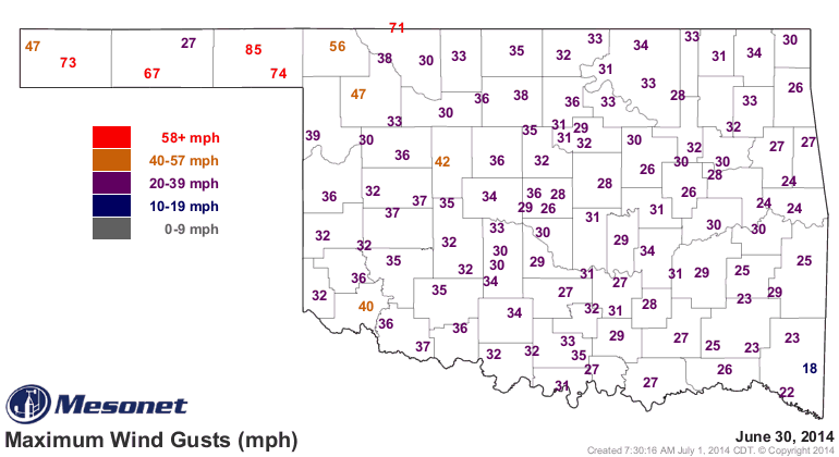
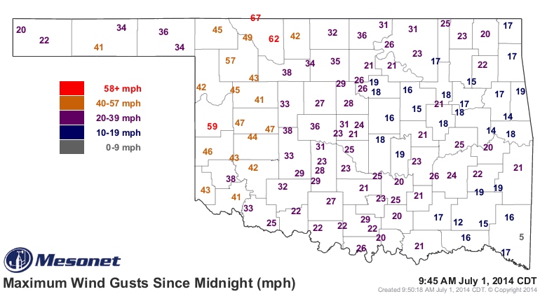
night's severe weather that struck the Panhandle and northwestern Oklahoma.
Reports of widespread wind damage came in from all areas of the Panhandle,
especially in the Guymon area. Winds of 70 to as much as 85 mph were reported
with the storms.
By the way, if you haven't visited our Facebook page, go check it out and you'll
get an amazing video of an old fashioned 1930s style Dust Storm near Boise City
from yesterday. Incredible video!
The other big news is MORE RAIN FOR BUFFALO (oh,and the surrounding areas).
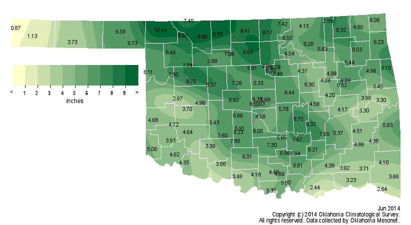
Buffalo's total for June came in at 10.44 inches, more than 6 inches above normal.
That's the highest June total on the Mesonet. This is not a shock, since Buffalo
generally leads the state in all matters, but 10.44 inches is a bit ridiculous.
Now, for some other news about June.
---------------------------------------------------------------------------------
Resurgent Spring Rains Continue In June
Although the spring rainy season got a late start in 2014, not arriving in
earnest until the third week of May, it continued with sustained vigor through
the last day of June. According to preliminary data from the Oklahoma Mesonet,
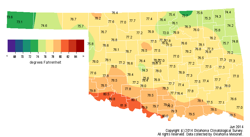
the month finished as the 23rd wettest June on record for the state with an
average total of 5.82 inches, a surplus of 1.56 inches. Those records date back
to 1895. North central Oklahoma, one of the areas hit hardest by drought since
the beginning of the year, saw its fifth wettest June with an average of 8.18
inches, 4.24 inches above normal. On the local level, six Mesonet stations
recorded at least 9 inches of rain for the month, all located across northern
Oklahoma. Buffalo led the state with 10.44 inches of rain, 6.36 inches above
normal. Cherokee and Lake Carl Blackwell reported 10 inches with Alva,
Breckenridge and Freedom exceeding 9 inches. Kenton recorded the state's lowest
total at 0.83 inches. The Mesonet recorded at least an inch of rain somewhere
in the state on 19 days during June. Not all areas were as fortunate with the
plentiful moisture, unfortunately. Locations along the Red River fell 2-4
inches below normal for the month. Durant reported 2.44 inches, more than 3
inches below normal.

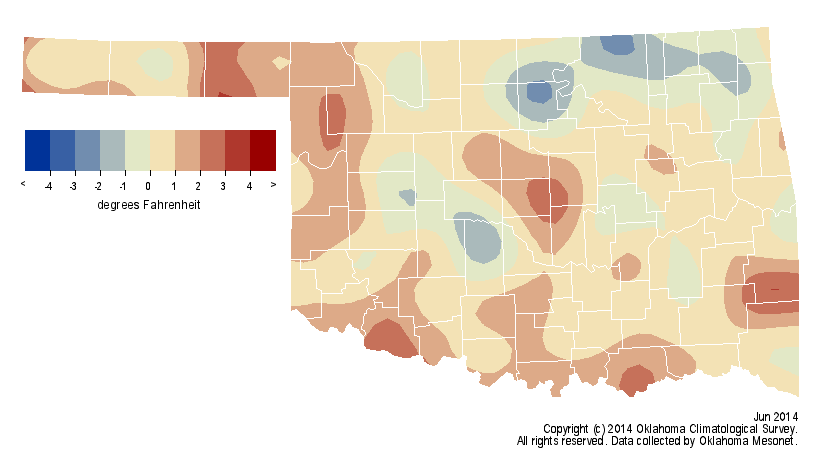
The statewide average temperature was 77.1 degrees, 0.6 degrees above normal
and the 54th warmest June on record. Grandfield topped the month's temperature
scale with a high of 107 degrees on June 4 and Kenton reached 43 degrees on
June 10 for the state's lowest reading.
The last few days of June were oppressively hot with heat index values well
into the triple-digits across most of Oklahoma.

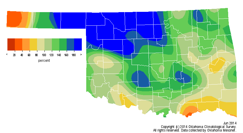
Except for delaying the wheat harvest and localized areas of flash flooding,
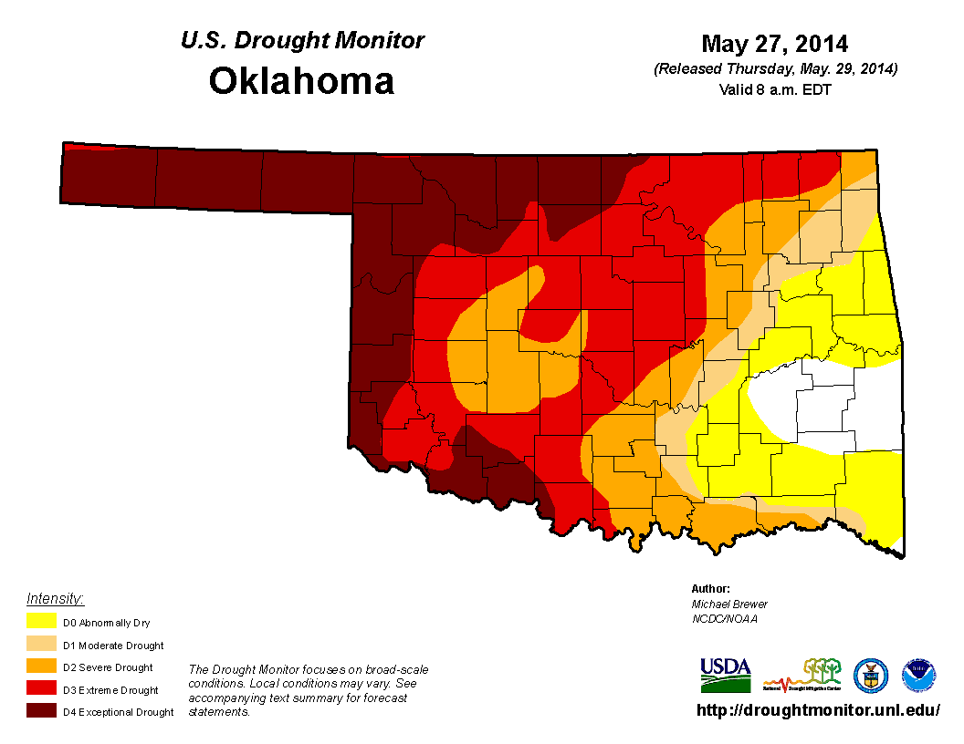
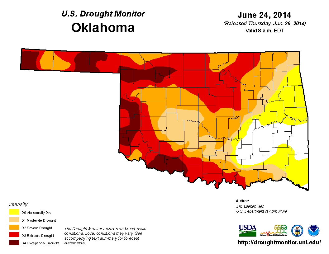
the excess moisture was of great benefit to the state. The U.S. Drought
Monitor, which had already seen a bit of improvement during the last two weeks
of May, continued to portray a drought of lessening intensity across much of
Oklahoma. The percentage of the state in at least severe drought dropped from
73 percent at the end of May to 66 percent at the end of June, and the
percentage of exceptional drought dropped from more than 26 percent to about
11 percent. The Drought Monitor?s intensity scale slides from moderate-severe-
extreme-exceptional, with exceptional being the worst classification.
Severe weather was sporadic and generally consisted of high winds and flooding,
although there were reports of large hail with some of the stronger storms.
The Mesonet site at Beaver recorded the top wind gust of 85 mph on June 30 with
Minco right behind at 83 mph on June 23. Much of the Panhandle was hit by
damaging winds on June 30. The Mesonet recorded severe wind gusts (57 mph or
greater) on 13 of June's 30 days. Preliminary reports from the National Weather
Service (NWS) indicate at least four tornadoes touched down in Oklahoma during
June. All four were of the weaker variety (EF1 or lower), although the tornado
that struck Adair on June 28 damaged several structures, including the Adair
Fire Department. The other three confirmed twisters occurred in rapid
succession in Beaver County on June 22. That brings the preliminary January-
June twister count to 11, the second lowest total for the first six months of
the year since accurate records began in 1950. Only 1988's count of 10 is
lower. Oklahoma averages eight tornadoes during June, and the average January-
June total is 47. All tornado data for 2014 are considered preliminary until
verified by NWS personnel.
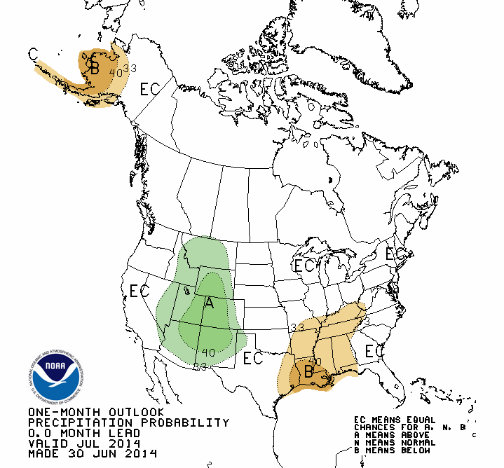
The July outlooks from the NWS' Climate Prediction Center indicate a chance
for below normal temperatures and above normal precipitation in the far western
Panhandle, but no clear signal for the rest of the state in either category.

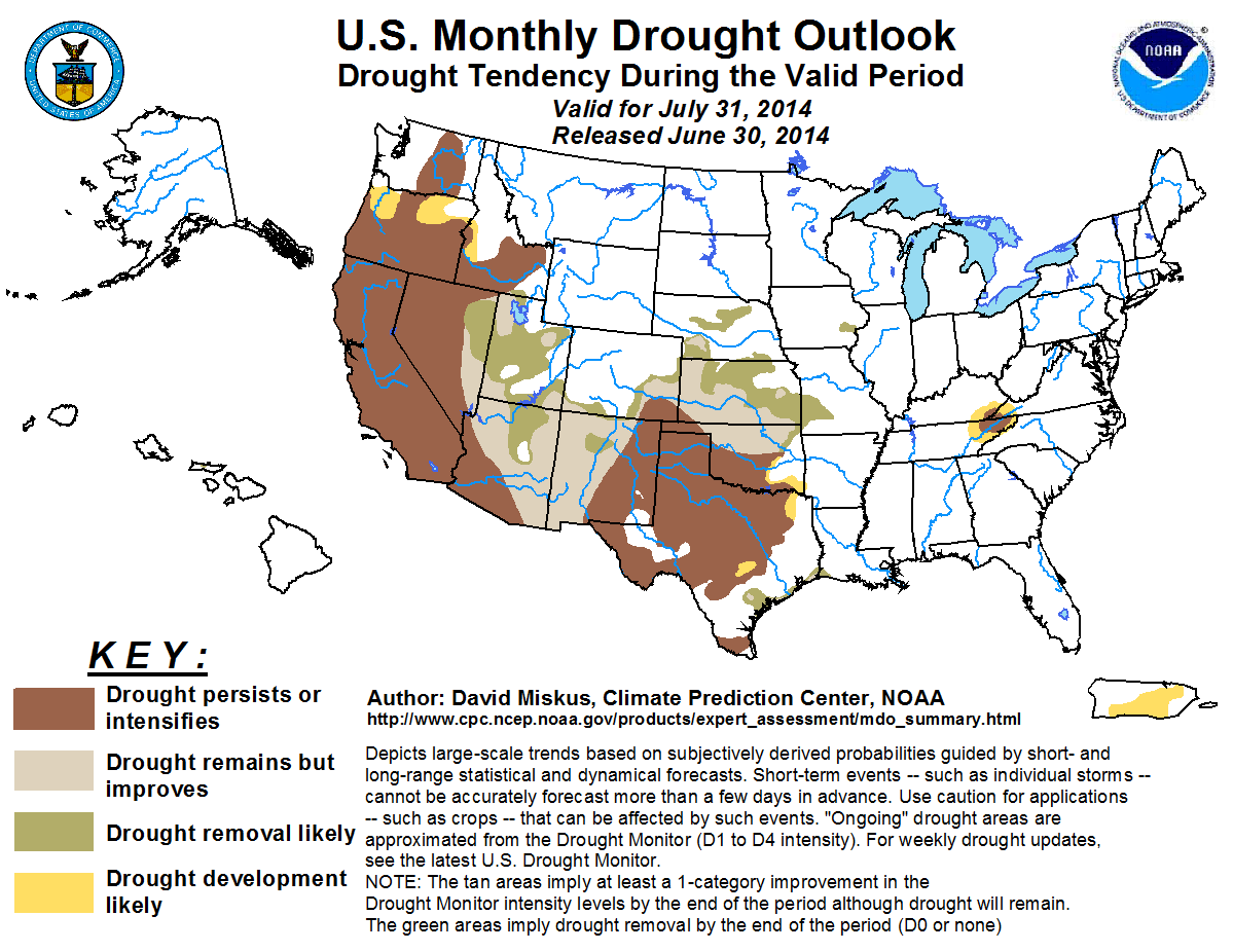
The U.S. Monthly Drought Outlook for July portrays drought as persisting or
intensifying across the southern half of the state and into the Panhandle, with
some improvement or removal likely across the northern half. Drought
development is indicated across southeastern Oklahoma.
Gary McManus
State Climatologist
Oklahoma Mesonet
Oklahoma Climatological Survey
(405) 325-2253
gmcmanus@mesonet.org
July 1 in Mesonet History
| Record | Value | Station | Year |
|---|---|---|---|
| Maximum Temperature | 110°F | ALVA | 1997 |
| Minimum Temperature | 50°F | EVAX | 2017 |
| Maximum Rainfall | 5.82 inches | PAWN | 2016 |
Mesonet records begin in 1994.
Search by Date
If you're a bit off, don't worry, because just like horseshoes, “almost” counts on the Ticker website!