Ticker for June 2, 2014
MESONET TICKER ... MESONET TICKER ... MESONET TICKER ... MESONET TICKER ...
June 2, 2014 June 2, 2014 June 2, 2014 June 2, 2014
Rain keeps on a-comin', and a summary of May's weather
Before we get to May, errrrr, go back to May (some people good with words ... me
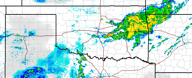
not), we had a real humdinger of a storm system last night form up in Kansas
and move down into north central and central Oklahoma. It brought heavy rains
and violent winds with it. Check out the rainfall maps from last night into
this morning.
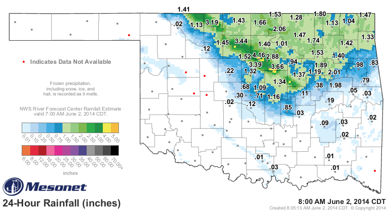
The Mesonet site at Lake Carl Blackwell picked up 4.16 inches of rain in a short
period of time, and those rains extended on down ot the southeast. A streak
along that route from just east of May Ranch through just NW of Okemah picked up
2-4 inches, with a few higher localized amounts. And the rain is still coming
down to the east of OKC up through NE OK.
Even the Panhandle got into the act a few days ago!
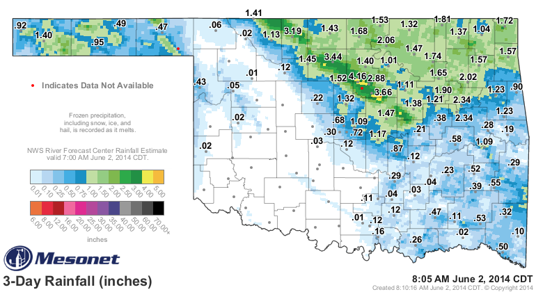
So keep in mind as you read the somewhat dire situation in some of those areas
below that they have received some rainfall, with more possibly on the way
for later in the week (in particular, northern Oklahoma).
Keep in mind as well that some of this forecast rain was what was expected to
fall this morning, but still good totals look possible later in the week.
Okay, settle in for the May summary. It was a very exciting boring month (just
wait, you'll get it).
---------------------------------------------------------------------------------
Tame May Sees Drought Relief, Few Tornadoes
June 2, 2014
Drought made significant advances across Oklahoma through the first three weeks
of May, aided by a string of hot, windy days coupled with a persistent absence
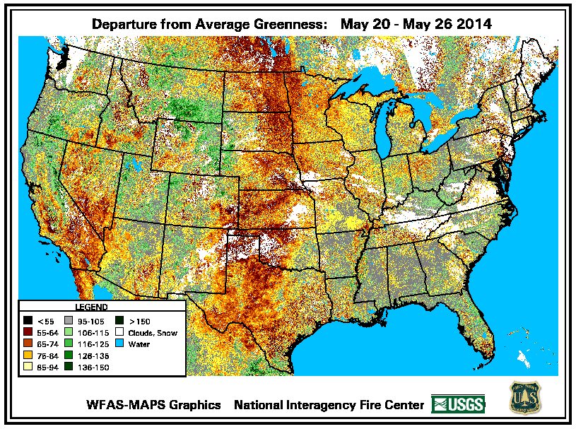
of spring rains. The prolonged drought preempted the normal spring green-up of
vegetation and extended the wildfire season well into May.
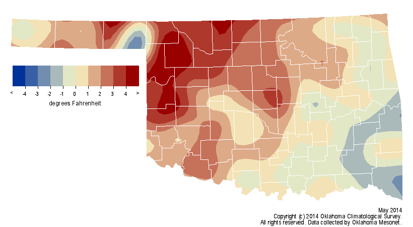
Departure from average greenness - satellite view
Fire danger rose to extreme levels prompting a state of emergency declaration
by the Governor as well as a burn ban for 36 counties across central and
western Oklahoma. More than 30,000 acres were burned in wildfires in just a few
days during the month's second week, including a fire in Noble County that
killed one person and destroyed or damaged 60 properties. Relief finally
arrived in the form of a slow-moving upper-level low pressure system camped
over the Desert Southwest. The spinning storm system allowed for ample moisture
return into the Southern Plains from the Gulf of Mexico, an ingredient sorely
lacking with other systems since the beginning of the year. The event's first
impacts were felt on the 21st with a few showers in the Panhandle and continued
through the end of the month as the storm moved slowly east and meandered about
the Ark-La-Tex region. Rain fell somewhere in Oklahoma on each of May's final
11 days.
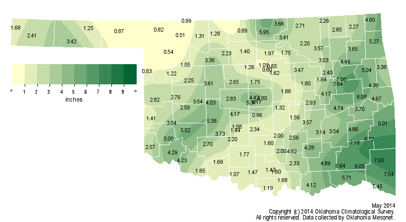
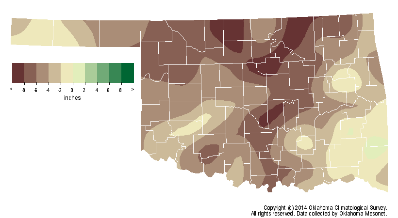
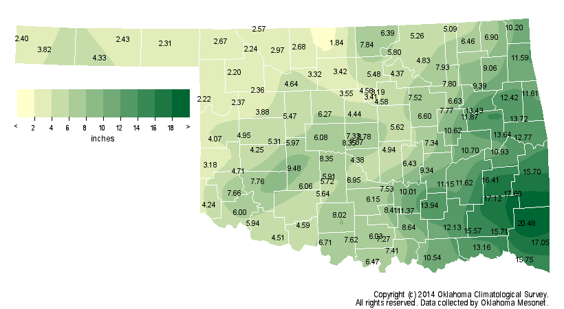
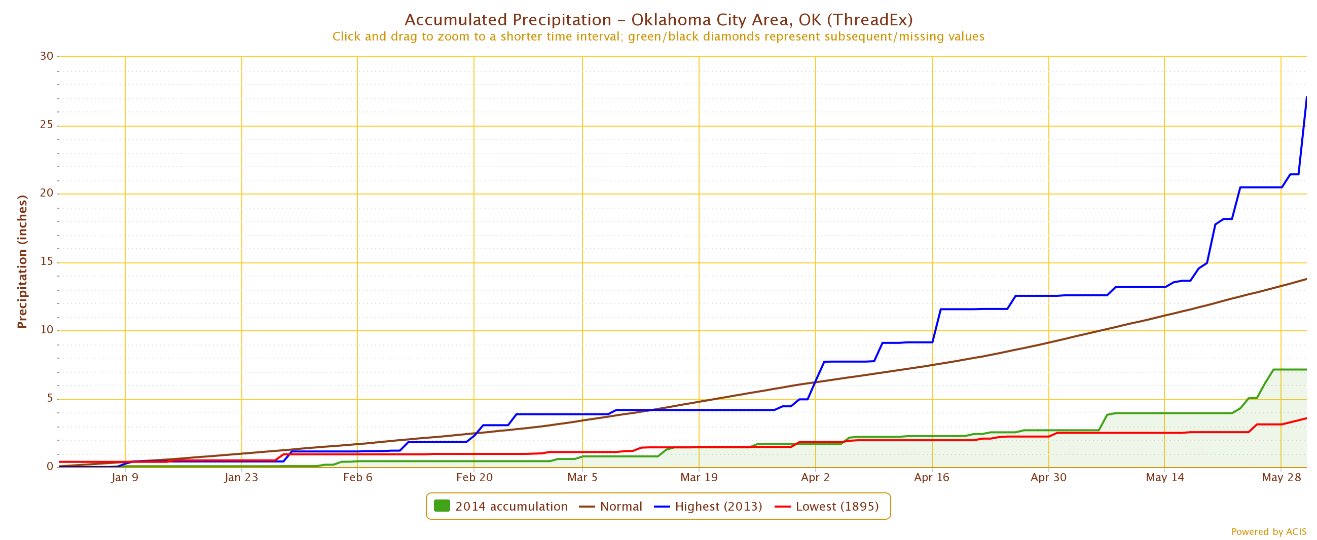
The highest monthly rain totals occurred in far southeastern Oklahoma with Mt.
Herman leading all Oklahoma Mesonet sites at 7.65 inches. Southwestern
Oklahoma, an area plagued by drought for well over three years, also saw
widespread 4-5 inch amounts. Even the central Oklahoma Panhandle received more
than three inches, which is about an inch above normal for that area.

Unfortunately, outside of those and a few other isolated regions, Oklahoma's
wettest month still came up short. According to preliminary data from the
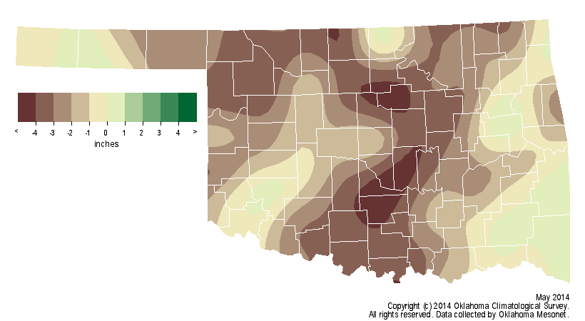
Mesonet, the statewide average rainfall total for May was 3.06 inches, 2.15
inches below normal and the 28th driest since records began in 1895. Central
and south central Oklahoma were particularly dry at more than 3 inches below
normal, the 19th driest and 13th driest May on record for those areas,
respectively. The lowest May total, 0.51 inches, was recorded at the Freedom
Mesonet site. Oklahoma's climatological spring (March-May) ended as the 10th
driest on record with a statewide average of 6.50 inches, 5.18 inches below
normal.
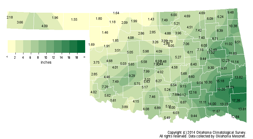
The January-May ranking was worse with an average of 7.32 inches, 7.57 inches
below normal and the third driest such period on record.
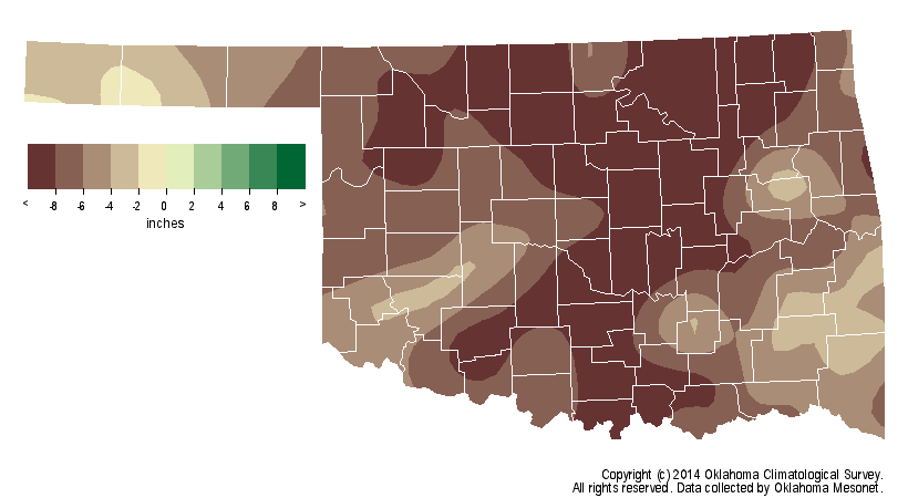
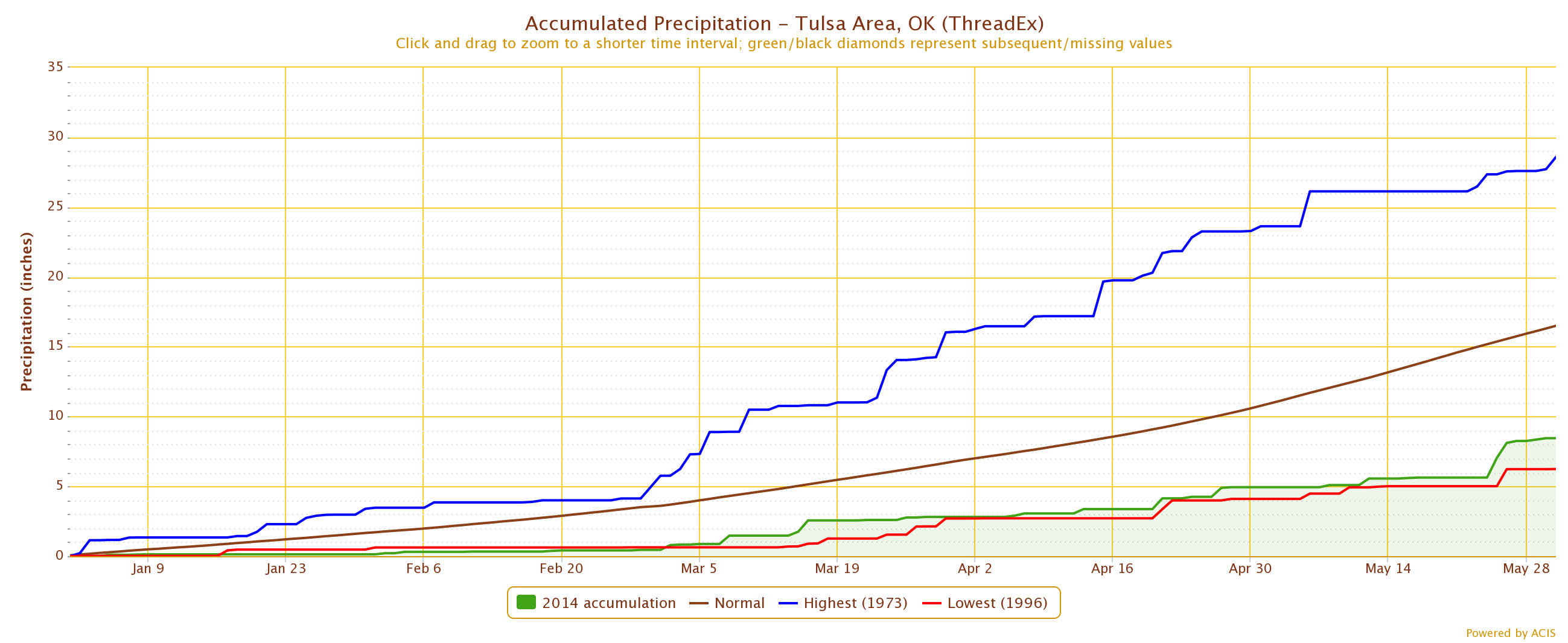
The first five months of the year were the sixth driest for Tulsa with a total
of 8.45 inches, approximately 8 inches below normal. Oklahoma City shared a
similar fate with 7.13 inches, a deficit of about 6.5 inches to rank as the
ninth driest such period on record.
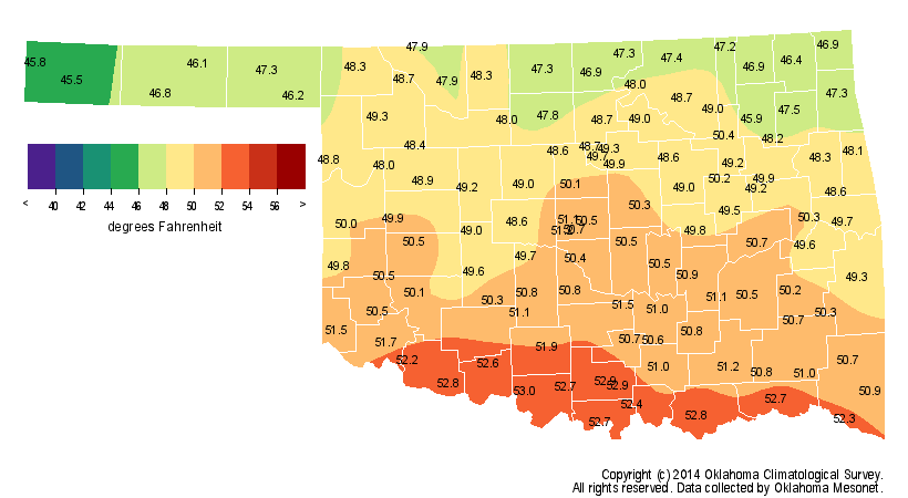
Owing to the extreme drought-fueled heat of the first half of the month, May
finished 1.2 degrees above normal with a statewide average of 69.1 degrees.
That ranked the month as the 39th warmest May on record, and also the first
month to end warmer than normal since September 2013. The highest May
temperature recorded by the Mesonet was 105 degrees at Altus and Cherokee on
May 5 and 6, respectively. The lowest temperature of 26 degrees was recorded
at Kenton on May 2, although it did freeze in the western Panhandle as late as
May 14.

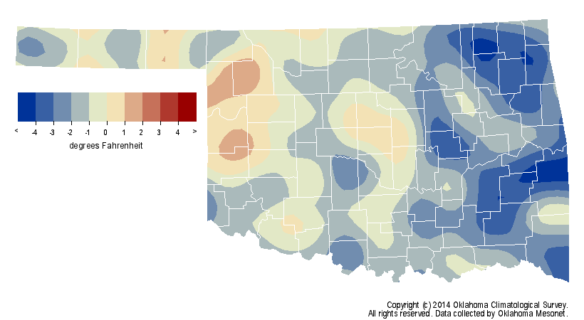
Climatological spring was quite cool with a statewide average temperature of
58.2 degrees, 0.9 degrees below normal to rank as the 38th coolest on record.
The January-May statewide average of 49.5 degrees was 1.6 degrees below normal
and the 23rd coolest such period on record.
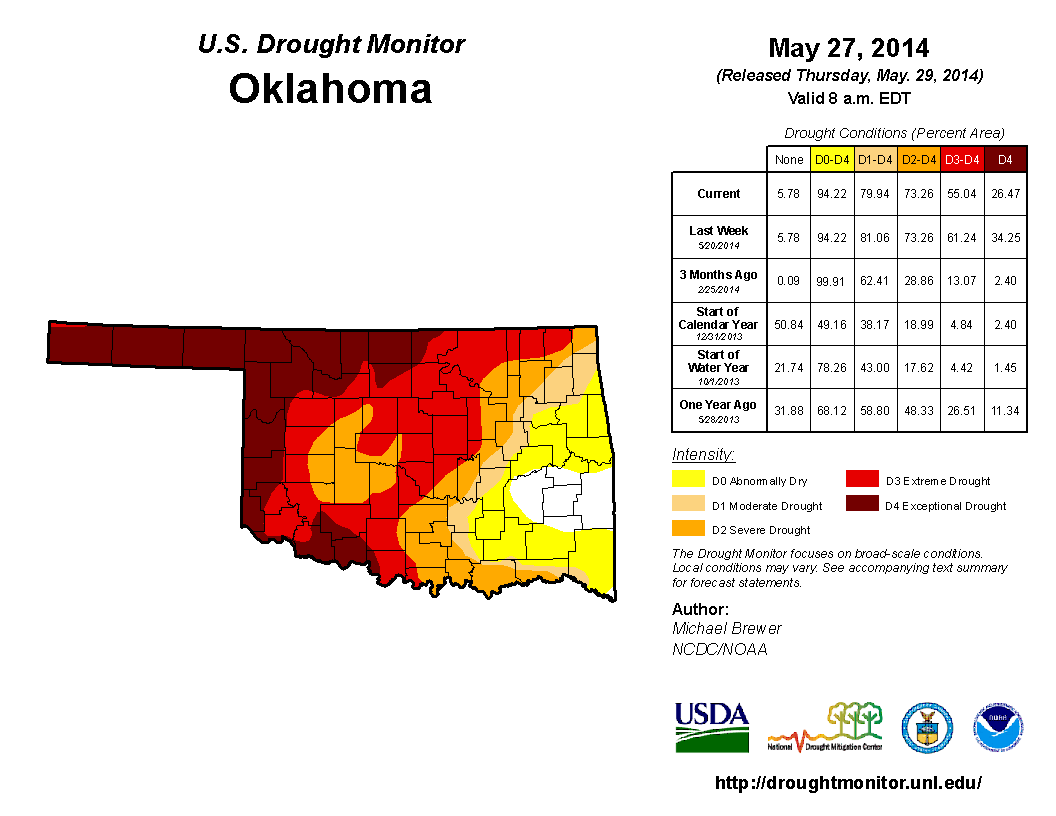
May ended with 80 percent of the state in drought according to the U.S. Drought
Monitor. Extreme-to-exceptional drought reached as high as 61 percent before
the rains began late in the month and finished at 55 percent. Over 26 percent
of the state remained in exceptional drought by the month's end. The Drought
Monitor?s intensity scale slides from moderate-severe-extreme-exceptional, with
exceptional being the worst classification.
Severe weather was nearly non-existent during May, normally Oklahoma's most
violent weather month. Preliminary totals from the National Weather Service
(NWS) indicate three confirmed tornadoes during May, which would tie 2012 for
the third lowest total since accurate records began in 1950. That total could
rise if NWS investigators find evidence of more tornadoes. The average tornado
count for May is 22. May 2005 holds the record for the lowest total at zero
and 2010 had the highest count at 91. The preliminary January-May tally of
seven tornadoes ties 1988 for the lowest total through the first five months
of the year. The 1988 annual total of 17 is the lowest on record. By the end
of May last year, Oklahoma had already experienced 79 tornadoes for the first
five months of the year, including 63 in May.
Hail to the size of baseballs fell on May 7 across southwestern Oklahoma in
addition to wind gusts of over 70 mph. Various other reports of flash flooding,
large hail and severe winds were reported later in the month in addition to the
tornadoes.
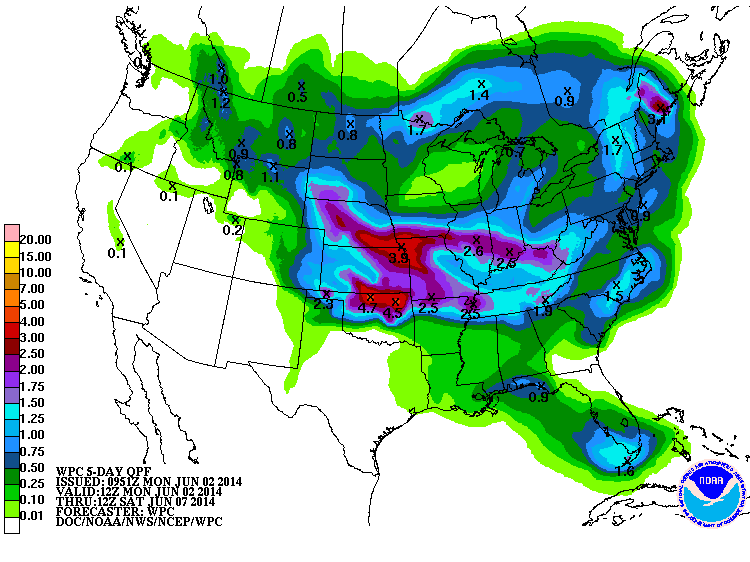
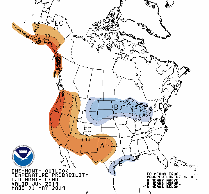
The June outlooks from the NWS' Climate Prediction Center (CPC) show increased
odds of above normal temperatures through western Oklahoma and above normal
rainfall in far northeastern Oklahoma. The forecasts are indeterminate for both
in other areas of the state.
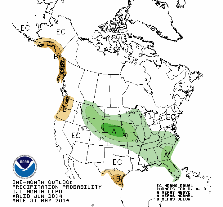
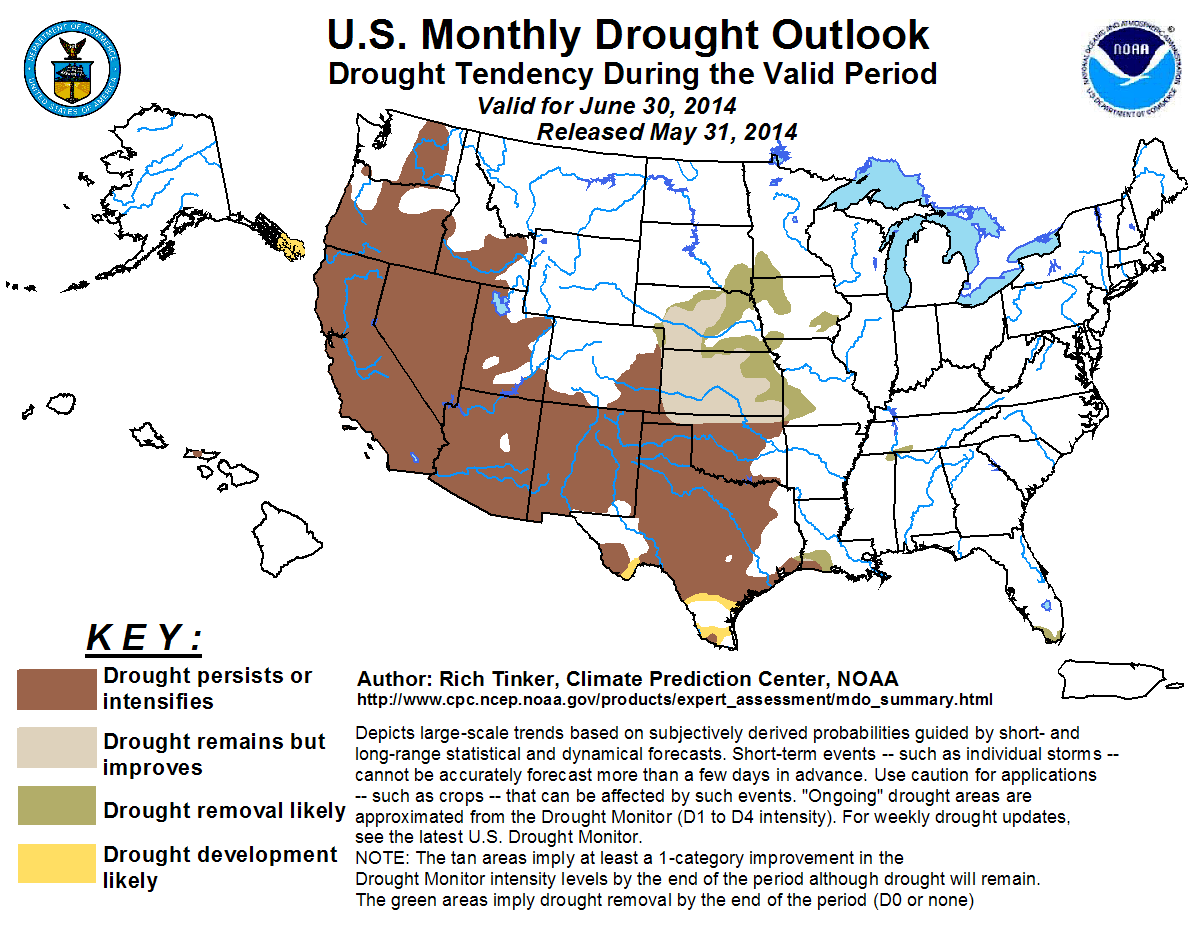
CPC's U.S. Monthly Drought Outlook for June calls for drought to persist or
intensify across areas where it is already in place, although some improvement
is possible across far northern Oklahoma.
June 2 in Mesonet History
| Record | Value | Station | Year |
|---|---|---|---|
| Maximum Temperature | 111°F | MANG | 1998 |
| Minimum Temperature | 42°F | HOOK | 2013 |
| Maximum Rainfall | 5.14 inches | WYNO | 2014 |
Mesonet records begin in 1994.
Search by Date
If you're a bit off, don't worry, because just like horseshoes, “almost” counts on the Ticker website!